The Cambrian Way 2010
Author: George Tod
This walk is illustrated with photographs. Click on small photo to enlarge in situ, or click caption to enlarge into new window.
The Cambrian Way 2010 |
||
|
Author: George TodThis walk is illustrated with photographs. Click on small photo to enlarge in situ, or click caption to enlarge into new window. |
|
| Part 12 - Days 20 and 21 - Idwal Cottage Youth Hostel to Conwy and Home | ||

[Index of Walks]
[Previous]
[Top]
[Next]
[Index of Walks]
[Previous]
[Top]
[Next]
The GPS mileage figure is what I recorded from accommodation to accommodation, and includes any small detours, meandering around, and errors in route finding. In general this is about 5% to 15% greater than the mileage calculated from a map, depending upon the type of terrain, but in some cases is considerably more.
The Italians were up at seven o'clock, so I did the same, as I wanted to get off fairly early though I still had the problem of what to have for breakfast if the warden hadn't managed to sort out some bread. I was thinking about it through the night and decided that I could use my second bag of rice to help fill me up, in addition to the individual portion pack of cereal I had bought.
I went down to the kitchen at 7.30 and the warden was not yet about, as reception didn't open until eight o'clock. By opening the bag of rice and boiling it in a pan with some milk, I was able to make a rice pudding, adding a large blob of jam from the free food shelf. It didn't taste too bad and, along with the cereal, went some way towards filling me up, but didn't leave me with very much for a packed lunch. Fortunately the warden was about at 7.45 and set about sorting out the bread. He didn't seem to realise that individual slices can normally be split off from a frozen loaf, so he had defrosted a whole loaf in the microwave oven. He was just about to defrost some butter portions in the microwave oven as well until it was pointed out to him that they were wrapped in metal foil, so it wasn't a very good idea.
Between us, the disabled lady and I had eight slices of thin white bread and eight butter portions. She only wanted two of each, so I made use of the rest, having two slices of toast with my breakfast and using the rest to make sandwiches with the other half of the tuna from last night. At the end of the day, I had managed to get enough food to keep me going, but it was not the easiest thing to do. It made me think that it would be a good challenge for one of those celebrity chef programmes on television, to face them with the contents of the hostel shop and challenge them to make breakfast lunch and dinner from it, without all the extra things they normally have under the counter.
When it came to paying for the bread, butter and teabags I had used, the warden had still to work out a price. The butter and teabags were priced at 5p each, which was fair enough, but then he suggested 30p a slice for the thin slices of bread, until I told him that it worked out at about £10 a loaf, which seemed a little excessive, even by YHA standards. He then settled on 10p a slice, which was more like a fair price. The warden was a nice enough chap, and was trying his best to be helpful, it was just that he was rather inexperienced and was struggling to cope with the setup there. The stock in the shop was obviously not down to him, but to some more permanent member of the YHA staff.
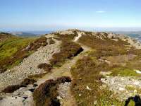
With all the messing about over breakfast, it was 8.40 before I set off from the hostel, only to realise that I still had the dormitory key in my pocket. Fortunately, I had not got very far when I realised, so it only wasted five minutes taking it back. If I had gone much further, I would have just posted it back to the hostel at the end of the walk. The path along the side of Llyn Ogwen has quite a few boulders and other obstacles to start with, though it does improve further along. The weather was very good again. There was some cloud over the Glyders, though not as much the way I was going. The lakeside walk is not all that good, as there is a need to keep a constant lookout for stones and other obstacles on the path, so not much attention can be paid to the scenery without stopping to do so. This route was chosen, and a checkpoint inserted at the end of the lake, to prevent people from taking the direct ascent of Pen yr Ole Wen and adding to the erosion problems that way, though there is some doubt now whether this is a real problem and whether there is just as much erosion on the preferred route. The steep ascent up Pen yr Ole Wen would, at least give bird's eye views of Llyn Ogwen, and would also save nearly two miles of walking on a day that is quite long and strenuous.
In fact, I have never noticed many people taking the direct route from Idwal Cottage and looking at the mountain face itself, there is not much sign of recent erosion, though there is some scarring that could well be due to landslip as much as it is due to walkers. The more popular routes to the Carneddau tend to be from the east, north and west, whereas Idwal Cottage tends to be the most popular access point for the Glyders. There is also another factor these days in that there is a parking charge at Idwal Cottage of £2 for up to four hours and £4 for over four hours, whereas at the other end of the lake, parking is currently free, as it is at a number of other access points.
It was getting hot low down, but started to get cooler as I made my way up the hillside at the end of the lake, having passed checkpoint 36 there at 9.45. There were several other people heading up from this end of the lake, but few of them had walked along the lakeside path. Just before the steep ascent onto the ridge, I stopped for a 15-minute rest and a drink at ten o'clock. There followed a steep scramble up rock slabs, made easier by there being plenty of handholds and footholds, and at least there was a rapid gain in height from it. Further up, the gradient slackened off and the summit came into sight, as well as the lake below. I reached the summit at 10.50, though I didn't stop there but carried on towards Carnedd Dafydd. These mountains are mainly round topped, so the views are mainly of mountaintops and other distant features, whereas to see the valleys fully often requires a detour to the edge. The paths were rather stony for much of the way, but the slopes were quite gentle and it was still possible to make reasonable progress. I reached Carnedd Dafydd at 11.20 (checkpoint 37), stopping for a 10-minute break.
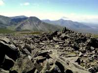
![]()
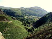
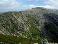 Carnedd Dafydd from Pen yr Ole Wen |
 Foel-goch and Elidir Fawr from Pen yr Ole Wen |
 Carnedd Dafydd from Bwlch Cyfryw-drum |
A few clouds were hovering over the tops, but not nearly so many as over the Glyders. Even Snowdon, which is notorious for gathering clouds around its summit, had less cloud than the Glyders. There were a few rocky crags to contend with on the way to Carnedd Llewelyn, but there were fine views down into the valley and back towards Carnedd Dafydd on the way. There was still some cloud about, so the views were not as good as I have seen on occasions, but then it is too much to expect perfect weather all of the time. As I started the final moderately steep ascent to the summit of Carnedd Llewelyn, I met the Italians from the hostel on their way back. They also had a woman with them whom I had seen at breakfast time. We greeted each other and wished each other well, as they headed back to the hostel and I continued on my way to the summit, which I reached at 12.25 (checkpoint 38). At 3,485ft (1,062m) this was the highest point of the day's walk and only 20m lower than Snowdon. I stopped to have my lunch of tuna sandwiches and flapjack. There were a few other walkers around, but not a great deal, especially comparing it with Snowdon on any day of the week.
The cloud was gradually clearing, but there was a large bank of it out at sea, looking like mist or fog. The Conwy Estuary was now in sight, as was Deganwy and the Great Orme, though my final destination of Conwy Castle was hidden behind Tal y Fan. At 12.50, I heard familiar voices - it was Richard and his friends, so I went over to greet them. They had started at about 9.30 at the far end of Llyn Ogwen and I must have been behind them at that point, so I am not sure how I got ahead without seeing them.
I was on my way again at 13.00, leaving the others at the summit. After the initial rocky descent from the summit, there was easier walking for much of the way now, with a lot of it over grassy paths, though each summit along the ridge tends to have a covering of stones and boulders. The views are less spectacular towards the northern end of the ridge, with rounded hills rather than steep mountains, though there were still some stunning views looking back. Although the scenery became less mountainous, the coastal views over the Menai Straits to Anglesey and Puffin Island got better, and the Great Orme and Conwy Valley got clearer. On the way down from Foel Fras, the last of the 3,000ft Mountains, there were lovely views of Llyn Anafon Reservoir and the coastal hills. Looking down from here, the rest of the hilltops along the ridge looked quite small and insignificant, but a few of them are still high enough to be classified as mountains, the last one being Tal y Fan, which at 2,000ft, just qualifies.
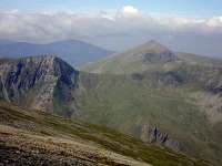
![]()
 Yr Elen from Gwaun y Garnedd |
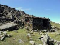 Mountain Refuge on Foel Grach |
 Yr Elen and Elidir Fawr from Carnedd Gwenllian |
After dropping down to the pass of Bwlch y Ddeufaen, the route of a Roman road and also where electricity pylons cross the ridge, I stopped for a fifteen-minute rest and a drink at 15.25 before facing the steep ascent of Foel Lwyd. After the long traverse of the Carneddau, this is the point where I have previously found it very hard, but this time the steep ascent didn't seem so bad. I put this down to psychology, more than anything else, as I had been psyching myself up for this, having remembered past experiences when I had been unprepared for this demanding effort towards the end of the walk. It also helped having had a fairly lazy day yesterday, though this was only the same as when I did my first walk of the Cambrian Way ten years ago, whereas on my second walk, I combined Snowdon and the Glyders into a single day, which was quite exhausting and left me less fit for the Carneddau. As I was climbing up, I thought I could see Richard and his companion coming down towards the pass, but I couldn't be sure, though there weren't many other people about, so it was quite likely to be them.
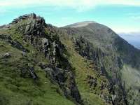
![]()
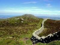 Tal y Fan from Foel Lwyd |
 Little Orme from Summit of Tal y Fan |
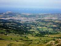 Little Orme, Conwy and Wind Farm |
After the steep ascent of Foel Lwyd, Tal y Fan involved considerably less ascent, but was craggier and, therefore, harder and slower going. I reached the summit at 16.20 (checkpoint 39) but only stopped for five minutes there to have a drink, as I still had over six miles left to walk. There was some more craggy walking along the ridge until the path dropped down past an old slate quarry and onto much easier paths along the edge of the common, where I could make faster and easier progress. At the end of the ridge was a clearer view of Conwy Castle and the route over the hills near the coast. Further along the route crossed from the east of the common to join the North Wales Path along the western edge of the common on the way to the Sychnant Pass and the first road crossing since the start of the day. On the way I passed through a large area where fire had spread over the hillside through the gorse and heather, leaving charred telegraph poles and wooden waymarking posts, the plastic discs of which were burned or melted beyond recognition. The vegetation will, no doubt, recover in time - in fact it used to be common practice to burn off areas of moorland in a controlled fashion in order to clear deadwood and to encourage new growth. This was before pollution and other environmental issues curbed the practice. However, this was obviously not controlled burning, and showed just what can happen after a period of dry weather, either by accident or, more likely, as a result of arson.
![]()
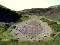 Dried up Llyn Wrach |
 Looking down Sychnant Pass to Capelulo |
 Conwy Estuary and Deganwy |
When I reached Sychnant Pass, having done several miles of fairly brisk walking with only a couple of short breaks, I was in need of a rest, so stopped by the gateway leading to the road. A fairly strong breeze was blowing the gate open against its counterweight, so I stopped at the opposite side of the wall to shelter from the wind, have the last of my drink, and write a few notes in my diary. A couple of ladies came through the gate and said hello. At first I thought that this was just a friendly greeting from strangers, but then I recognised one of them who had been walking with Richard a few days ago, and was the wife of his companion today. The other lady was Richard's wife, who had been doing all the driving to and from the various starting and finishing points along the way. They were waiting here to check on progress, and I estimated that Richard and his friend would be along in about a quarter to half an hour, judging from their progress earlier. They gave me some bottled water, as they had plenty of supplies in the car. It was much appreciated, as I was still thirsty, and I downed it in one.
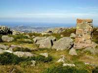
![]()
 Summit of Conwy Mountain |
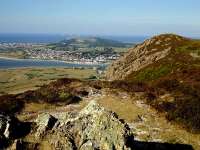
 Conwy Castle from Conwy Mountain |
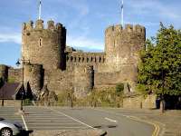 Conwy Castle - End of the Cambrian Way |
They congratulated me on my walk, and I thanked them and asked them to pass on my good wishes to their husbands, as I set off on the final leg of the walk over Conwy Mountain. There was still some climbing to do, but I was spurred on by the thought that the end was in sight, so it wasn't much effort to make the final ascent to the old iron-age fort. From there, the castle loomed much larger down the path ahead, and there were fine views of the Marina, the Great Orme and the estuary. I was just about to phone to arrange a pickup when my daughter Jen rang my mobile and I gave here an E.T.A. of 19.15, arranging to meet her on the bridge just beyond the castle. The castle grew larger and larger in my view, as I made my way down the ridge in lovely evening sunshine, until the path dropped down into the edge of town. I reached Conway Castle, the final checkpoint number 40, at 19.10, and then met Jen and my wife Jean, who were waiting in the lay-by at 19.15. They couldn't believe the dark brown colour I had turned after three weeks with such a lot of sunshine. It was then just a matter of being driven the twelve miles back to Abergele, where I had a bottle of Reverend James, a relaxing bath and a lovely meal, somewhat different from the one I had cobbled together from last night's limited supplies.
[Index of Walks]
[Previous]
[Top]
[Next]
After a few years of long distance walks that had been marred by prolonged periods of bad weather or other problems, this made a very welcome change, with far better weather than I could have hoped for over such a mountainous route. There is no doubt that the weather can make a big difference to the enjoyment of the walk, and this was definitely the thing that made the walk so successful this year. Even though I suffered for a while from blisters and foot ache, the magnificent scenery in which this walk abounds, kept up my spirits and helped me forget my problems. I have generally come to the conclusion that the Cambrian Way is the best long distance walk I have done, and I am not aware of any other, in the UK at least, that can compare, so I extend my thanks once again to Tony Drake for all the work he has done over the years putting together the route and maintaining the guidebook.
As always, I had some reservations about my schedule, which sometimes meant I was doing longer days than were ideal, so I had to push on towards the end of the day to reach my destination in time to get a meal. Much of this, though, was dictated by the availability of accommodation, which is very sparse in some parts, so on balance it worked as well as could be expected, and I never had too much difficulty keeping to my schedule. It is always worth remembering on a mountainous walk like this, that it is not only the mileage of each stage that has to be considered, but also the ascent and some of the going over rough ground, so extra time should be allowed to cater for this. There is also the fact that distance measurements over steep or craggy sections can be considerably less than that actually walked, as they are almost impossible to measure properly from a map. In many ways, the guidebook would be better using GPS measurements of the actual walk, but this would mean double-checking every section of the walk and its variants to get a consistent set of figures. Although I took my own GPS measurements each day, there were times when I deviated from the route, either by accident or design, thus invalidating many of my measurements. All I know is that most days I walked more distance than quoted in the guide. Sometimes, over gentler parts of the route, the difference was only about 5% or less, which is only to be expected, but other days it amounted to much more than that and made a significant difference to the mileage. The total mileage for the main route in the guidebook is 275.2 miles, but the total distance I clocked up on my GPS was 368.9 miles, a difference of 93.7 miles - almost a week's worth of extra walking! There are a number of reasons for this:
- Although a lot of my accommodation was close to the route, there were a number of occasions when I had to make long detours, some of these on alternative routes shown in the guidebook and some of my own making. This accounts for perhaps about half of the extra distance.
- Distance measured on the ground is always greater than map measurements suggest, particularly over steep and rugged terrain. I would estimate that around 30 miles could be attributed to this.
- There were a number of occasions when I made detours from the route for sightseeing or to get better viewpoints for photographs. This could account for about 10 to 15 miles.
- On several occasions I made errors of navigation which resulted in several extra miles.
- It cannot be assumed that GPS measurements are entirely accurate. Each position calculated is, at best, accurate to within several metres and this results in a random scattering of position measurements along the actual path walked. Software in the GPS attempts to average this out to give a better approximation to the correct route, but there is still room for error. This is particularly pronounced when satellite signals are obstructed by overhanging branches or other obstructions including ones own body. This can give rise to much reduced accuracy and the possibility of greater errors even after attempts to average them out by the GPS receiver. However, this is likely to be a fairly small factor in the overall discrepancy.
One thing that was highlighted by this walk, in particular, was that it is possible to suffer from blisters early in a walk and for them to heal up and recover during the walk despite the constant aggrevation from continued daily walking. I started to suffer from blistered heels in the first few days and they got to their worst by the end of about a week. From then onwards they gradually improved to the point where they were no longer a problem for the last week of the walk. Nevertheless, it is best if they can be avoided in the first place, though this is often easier said than done.
One thing that pleased me very much was that, despite my advancing age of 65, I found the walk no more difficult than on previous occasions. There are always good days and bad days and these do not always occur in the same parts of the walk each time, but on balance I managed just as well this time. This means that when I am planning future walks, I will not need to adjust my schedules significantly, at least for the time being, and will just carry on as normal without making any concessions for my age until such time as it becomes apparent that I need to do so.
There is a tendency to think that, having done the same walk twice before, route finding should be easy and that few mistakes should be made. In practice, I find this to be almost the opposite of the case. Although it is reassuring to see familiar landmarks, I have a tendency to be less attentive to route finding, and often continue along paths, missing turnings because I have not been giving my full attention to maps and guides. The only thing is that, having missed my way, it is not generally very long before I realise it and I am able to make corrections before I have gone too far. I have also come to the conclusion that for a walk like the Cambrian Way, with little or no waymarking, and some difficult navigation required at times, the 1:25,000 Ordnance Survey maps are considerably better than the 1:50,000 maps. There are a number of other walks where less detailed maps are adequate, but it is generally an advantage to have that extra detail. The only problem with this is the extra cost and weight of the maps. For National Trails, this is generally solved by the guidebooks, which contain sections of 1:25,000 maps for the whole route, thereby meaning that no extra maps are required, though it is often not easy to find the way back onto the route, having drifted off beyond the bounds of the narrow section of map in the guide. However, with the ability to get an accurate grid reference using a GPS, some of these problems are eliminated or greatly reduced.

[Index of Walks]
[Previous]
[Top]