Part Cambrian Way 2017
Author: George Tod
This walk is illustrated with photographs. Click on small photo to enlarge in situ, or click caption to enlarge into new window.
Part Cambrian Way 2017 |
||
|
Author: George TodThis walk is illustrated with photographs. Click on small photo to enlarge in situ, or click caption to enlarge into new window. |
|
| Part 3 - Days 3 & 4 Maentwrog to YHA Llanberis | ||

[Index of Walks]
[Previous]
[Top]
[Next]
[Index of Walks]
[Previous]
[Top]
[Next]
The GPS mileage figure includes small detours, meandering around, and errors in route finding. In general this is about 5% to 15% greater than the mileage calculated from a map depending upon the type of terrain, but in some cases is considerably more.
Breakfast was from 8am, though it could be earlier by request. Most of my things had dried out quite well, which is always a good start, and the weather had also cleared up considerably, with a good forecast for the day ahead. I was chatting to Eveline about the walk and also about Welsh, which she had been learning. I was completely gobsmacked when she said that the Welsh grammar was easy. The thing that people consistently complain about is how difficult the grammar is in Welsh, particularly mutations where the first letter of a word can change because a whole list of possible reasons, so when I asked "What about mutations?" she replied "Oh I don't bother with those. Most of the locals don't use them anyway!" I also mentioned that she would be a lot better placed for practising her Welsh here, where most of the locals are Welsh speakers, than I am near Rhyl where hardly anyone speaks Welsh. However, she said this was not so, as whenever she spoke in Welsh, the locals would speak back in English.
![]()
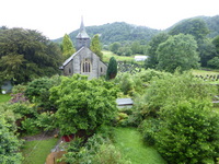 Maentwrog Church from B&B Window |
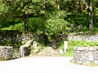
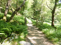
I set out at 9am with low cloud all around but it was starting to look a bit brighter and was not too cold. The route started off by going north out of the village on the A496 and, after crossing the River Dwyryd, it turned right along a minor road eastwards along the Vale of Ffestiniog. After a few hundred yards, a path bears left to enter the Coedydd Maentwrog National Nature Reserve, which had a large marker post at its entrance. There was some concern by the Snowdonia National Park Authority that this part of the path was not actually a right of way as it is only shown as a dotted line on the O.S. map, but there was nothing to indicate that there was any restriction on its use and the path led to another gate at the end of the Nature Reserve where a right of way is shown again on the map. There was a suggestion that the Cambrian Way route should be changed to continue along the road to bypass this section, which would involve over half a mile of additional road walking, but there seems no reason to do so in the circumstances.
The route emerges from the woods by a house where I made the silly mistake of turning right down its driveway whereas I should have found a path going uphill round the eastern side of the house. I was too busy checking out the disputed path that I failed to concentrate on where I should be going next. I found paths going across field for a while, but these eventually came to a dead end, and by this time I should have been on a path higher up the hillside. My only option now, without backtracking, was to climb up the very steep hillside covered in bracken and trees. It was not a pleasant experience and by the time I reached the upper path I was dripping with sweat and cursing myself for wasting so much energy and some extra time right at the start of the walk.
![]()
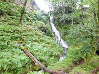 Waterfall near Dduallt |
 Towards Tanygrisiau Reservoir |
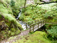 Footbridge near Moelwyn Mine |
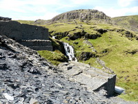
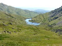
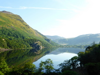
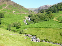
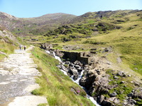
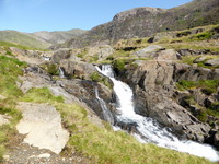
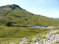
Having reached the correct path, the going was much easier, though still steep in places and I passed a high waterfall before reaching the narrow zigzag road that leads up towards the railway line of the Ffestiniog Mountain Railway. A path then runs parallel to the line before crossing it on the way to Dduallt station. It was pleasant now to end the steep climbing for a while and the station offered a convenient location for a short rest. There was still a long walk ahead, so I didn't stay long and pressed on along the track following the line until the line went through a tunnel through the top of the hill, rejoining it at the head of Tanygrisiau Reservoir. The cloud had now lifted from most of the mountains ahead, though it was still overcast as I crossed the line again to take the path up towards Llyn Stwlan, which is the upper reservoir of the pumped storage system. When electricity demand is low, turbines in the power station by Tanygrisiau Reservoir pump water to Llyn Stwlan and when peak demand occurs, the water flow is reversed to produce energy at very short notice. Additional energy is gained from streams that feed into the upper reservoir so that a high percentage of the energy used in pumping is regained at a time when it is far more valuable in balancing sudden demands on the grid. At such times it is possible to see the water level of Llyn Stwlan visibly dropping.
![]()
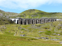 Llyn Stwlan Dam and Moelwyn Mawr |
 Llyn Stwlan and Dam |
 Llyn Stwlan and Moelwyn Mawr |
The very nature of this setup means that there is a steep hillside to climb, though for those who prefer a somewhat gentler climb, it is possible to continue along the track by Llyn Tanygrisiau past the power station towards the village and then take the service road to the dam of Llyn Stwlan, then cross it the dam to rejoin the route. However, this adds over two miles to the walking distance and, although the walking is quicker it is likely to take about three quarters or an hour longer. I stuck to the steep route and the views behind me opened up more as I climbed upwards, with fine views across Tanygrisiau Reservoir and Blaenau Ffestiniog, though there was still a bit of cloud lurking ahead. However, as I got above the steep hillside leading to the dam, the sky quickly cleared and the whole vista of the dam and the Moelwyns was bathed in sunlight. Once I reached the dam it was about 12.30 so I stopped for a lunch break and a rest, enjoying the sunshine, which had been in short supply so far.
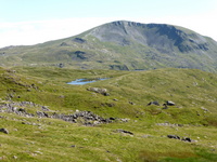
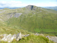
After three quarters of an hour, I realised that, much as I was enjoying the fine weather, there was still quite a lot of walking to do and I needed to press on. After wet weather, the more direct route to Moelwyn Mawr can get rather boggy, so I took a longer route along a rocky ridge to the left, joining the path to Moelwyn Mawr a little further south where it skirts around Moelwyn Bach. The views over the two reservoirs with the mountains around were quite spectacular, especially in the bright weather, and I made my way up the steep, craggy path to Moelwyn Mawr. This is one of those mountains where you can keep thinking that the summit is nearly there only to find that there is yet another rise ahead. Also, on the way, there is a lesser summit and a slight dip down before the final ascent to the real summit, which levels out to a grassy slope towards the trig point at the top.
The Panarama from Molwyn Mawr
![]()
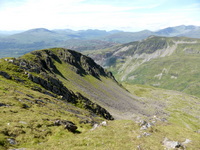 West Snowdonia, Cnicht and Snowdon |
 North to Moel Druman and Moel Siabod |
 East to Moel-yr-hydd and Blaenau Ffestiniog |
![]()
 Moelwyn Fach and Llyn Transfynydd |
 The Coast at Porthmadog |
 Coast Towards the Llyn Peninsula |
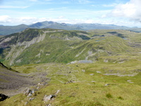
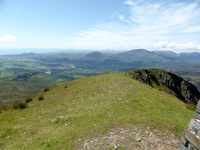
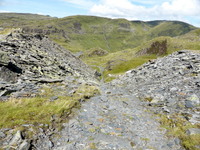
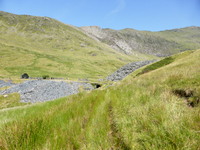
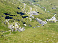
I had set off in the morning with two and a quarter litres of water, but in the hot weather this was diminishing rapidly, so I was trying to ration it out as there was still a long way to go. Once on the summit, there was a whole panorama, with a fine view of Moelwyn Bach and the coast near Porthmadog and Moel Hebog and other mountains near Beddgelert. Further round stood Cnicht with Snowdon towering over it from behind and there was a whole host of other Snowdonian mountains as well as many lakes. There were a few other walkers here and there, but generally I had the place to myself for much of the time. It was about 2.30pm when I got to the summit and after another quick stop for a drink and a snack I continued on my way down a more gentle grassy slope to the disused Rhosydd Quarry below. There are a number of ruined buildings from mining and quarrying as well as a series of inclines that were used for tramways to take the slate and minerals down to the valley below. This area was a hive of industry in bygone days when Welsh slate was used to roof buildings throughout the world.
![]()
 Incline at Rhosydd Quarry |
 Cwmorthin Quarry Buildings |
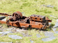 Old Engine, Cwmorthin Quarry |
Being rather concerned by my limited reserves of water, I was looking out for somewhere to get some more. People are always warned about drinking water from streams in Snowdonia, as in most areas the water drains over the surface and is not filtered through sedimentary rocks underground. Hence, there can be contamination from sheep droppings and the level of e-coli can be way above recommended safe levels. However, my thoughts on this are that the greatest danger is when there has been a long, dry spell followed by light rain, which means that any contamination is more concentrated. If there have been prolonged periods of heavy rain, as there had been recently, contamination would be considerably diluted. On the way down the inclines there were places where small streams were emerging from the adjacent rocks and these looked quite clean and fresh, so I had a good drink and took some more in my water bottles.
![]()
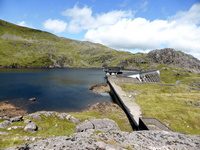
 Waterfall, Cwmorthin Quarry |
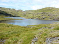 Llyn Cwm-corsiog |
 Cnicht |
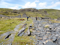
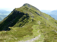
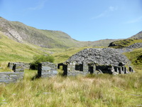
There is a large levelled area with lots of ruined buildings that remain from the main quarry at Bwlch Cwmorthin and this is a popular place for visitors who want a taste of Wales's industrial heritage as well as walkers who want to explore the numerous lakes, some natural and some man-made, as well as several mountains over 2,000ft in the area. The paths on maps are not always easy to follow, but it is not too difficult to walk over the rough ground, picking up on paths for a while and then losing them, which makes it difficult when trying to define the Cambrian Way route with any degree of certainty, though the main objective is to reach the ridge leading to Cnicht (Knight). This is sometimes called the Welsh Matterhorn because of its appearance from the south, though it is tiny compared to the real Matterhorn. Although I have walked around this area several times, I still missed part of the path in places, but picked it up further along where it becomes more distinct. It is always a bad sign when a right of way is shown as an almost straight line in an area that undulates a lot, as it generally means that there is no definite route, just the right to make your own way from A to B. In fact the most well trodden routes can sometimes vary from one year to the next as people keep walking different ways.
![]()
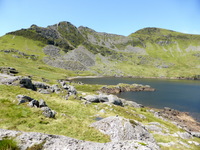
 Cnicht (Knight) |
 Llyn Cwm-y-foel |
 Llyn Cwm-y-foel and Moelwyn Mawr |
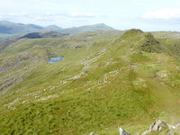
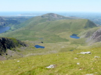
Once onto the ridge, it is quite easy going most of the way to the summit of Cnicht. There are one or two slightly different paths, but they are all heading to the same place, some keeping to the highest part of the ridge and some taking easier routes by skirting around some of the craggy parts. I met a few walkers on the way, but not many were at the summit where I arrived at about 16.50. Again, there were spectacular views all around with mountains and lakes being shown at their best in the glorious sunshine. I was starting to get concerned about the time, as I was counting on getting an evening meal at Bryn Gwynant Youth Hostel and these normally have to be booked by 18.00 and are served at 19.00, although some of the larger hostels do offer more flexibility. There always used to be a request not to phone the hostel before 17.00, though I think that this may no longer apply. I had a good mobile signal on Cnicht, but I decided I would wait until after 17.00 to phone and set off on my way back along the ridge to head for the hostel. The normal route continues south down the steep face of Cnicht, heading round via Beddgelert but the hostel route is more direct.
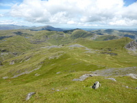
The Panarama from Cnicht
![]()
 Cnicht Summit |
 Llyn Cwm-y-foel and Llyn Cwm-corsiog |
 Moelwyn Mawr |
![]()
 Cnicht Ridge, Llyn Biswail and Moel Siabod |
 Yr Aran, Snowdon and Tryfan |
 Moel Hebog and West Snowdonia |
As I made my way along and back down past Llyn yr Adar, I decided it was about time to phone, only to discover that I had no signal and the good reception I got at he summit must have been coming from the Porthmadog area, which was now well and truly hidden by mountains. Parts of the route were fairly quick, but there were quite a few places that were craggy and slow going, so I wasn't making progress as fast as I would have hoped. Every so often I checked my phone, but it was obvious that the lower down into the valley I got the less chance there was of a signal, so I eventually gave up hope and just pressed on as quickly as I could in the hope that, even though I was going to be late, there may be some food left that I could have.
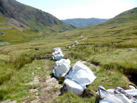
Once down from the steep mountainside, there is a fairly level right of way leading across to the hillside above the hostel, with a path, not marked as a right of way, going off to the hostel for the use of hostellers. When I last came this way, there was a small sign indicating the turn off, as mentioned in the guidebook. However, when I got near to this point, the whole area had been churned up by heavy vehicles, probably for logging, and it was very difficult to be sure of the right direction to take. I had the route in my GPS, so just kept trying to follow that until I came to a corner of a wall and no apparent way of getting over without climbing it. I followed it a bit to the left, but that way was overgrown and not easy to follow, so I went back to the corner again and then noticed not far from the corner, a stile made of stone slabs sticking out of the wall, rather than a wooden ladder stile. However, shortly after crossing over, I was confronted with a large fallen tree that had obviously been there for some years. There was no way I could see to get round the tree but there was a gap underneath of about two foot and muddy ground below. I took the quickest option of crawling under despite the mud and just squeezed under with my rucksack still on my back, though I thought I was going to have to take it off at first.
There were then paths going in different directions through the woodland, which is part of the hostel grounds and I knew that if I just kept going downhill I would eventually see the hostel. By this time it was nearly 19.30 and hopes of a meal were getting slimmer but there was still a possibility that there may have been something left over. When I arrived at reception and asked about food I was told that only that which had been ordered had been prepared and the main course was just being taken to the tables. I asked if there were a hostel shop, but the answer was 'No', which was rather surprising for a quite large hostel where the nearest pub is about four miles in either direction. When I mentioned the difficulty on the route, I was told that few people use it these days, so it has deteriorated, or maybe it is because it has deteriorated that it is not used much!
Food may have been out of the question, but there was a large selection of drinks available throughout the evening, one of modern profit making ventures of the YHA. I still had some provisions with me that I had brought from home, as I had not been eating all that much whilst I was walking so I was able to have some nuts, cereal bars and chocolate plus a couple of 500ml bottles of local ale from the hostel at £3.60 each. As it was a beautiful evening, I took these outside to a table overlooking Llyn Gwynant, but I had forgotten just how bad the midges are around here because of all the woodland, and I soon had to retreat inside.
One thing I should have thought of regarding food is that in the self catering kitchen people often leave half used packets of things on a special shelf so that other hostellers can help themselves. There is generally an odd assortment of things, but there are often packets of rice, pasta and cereals which can can provide some nourishing addition to snack food. However, I felt reasonably fed and watered and I had booked a full breakfast for the morning, so that would help me on my way.
In my earlier days of long distance walking, I always felt ravenously hungry and could eat anything that came my way, which often included finishing off meals that others couldn't eat, but as I have grown older it seems to work the other way. Once I get into the mode of strenuous walking, my stomach seems to go on strike and I end up having to make myself eat things because I know I need them to give me energy.
The one good thing about many youth hostels is that they have good drying rooms, that is if the heating is turned on in them, and in this case it was. This meant that I could wash out a few of my sweaty clothes without worrying whether I could get them dry. My boots were a different matter, as my left one was deteriorating badly, with a loose flap of leather hanging down at one side. They still felt alright to walk in and the Gore-Tex lining continued to hold back most of the wet, but I still had a lot of rugged mountain walking to do, so it did make me wonder if I could keep them going to the end. At a push, I could walk in my trainers, but this was not an ideal option, as there was more chance of slipping in places.
When I say that my boots were keeping out most of the water, this does not mean that my feet kept dry, as the wet gradually penetrated making my socks and feet permanently damp, but I wasn't getting water rushing in when I stood in puddles. In changeable weather conditions, even when it is fine and sunny, there is still a lot of waterlogged ground to contend with, so I have never found it possible to keep my feet dry. With the boots in such a sorry state, it was hardly worth trying to wax them, especially as I found I had left the wax at home, so I just left them in the drying room hoping to reduce the water content overnight.
One big shortcoming I have found with many hostels is the lack of space in dormitories for people to put rucksacks, clothing and personal belongings. When a dormitory is only half full, everyone who wants a lower bunk can have one and there is space underneath and at the ends to stow things. However, when it comes to people having to take an upper bunk, there is nowhere at all if the person in the lower bunk has used the space below. When hostels get refurbished, which is not all that often, they try to provide individual lockers, but these take up space and it may be necessary to reduce bed numbers to accommodate them, so it has to be carefully considered. Fortunately, this hostel wasn't too busy, so it wasn't a problem.
[Index of Walks]
[Previous]
[Top]
[Next]
The GPS mileage figure includes small detours, meandering around, and errors in route finding. In general this is about 5% to 15% greater than the mileage calculated from a map depending upon the type of terrain, but in some cases is considerably more.
There were less miles to walk today, but still a fair amount of ascent, climbing Snowdon from near sea level plus a few other ups and downs. Hopefully, I could take it at a more relaxed pace whilst still getting to Llanberis Youth Hostel in time for an evening meal. Even if I didn't make it on time, there were pubs not far away that I could visit. I went down to breakfast at about 8am and had my standard YHA full breakfast, which was quite substantial, though not quite as much so as breakfasts served in most B&Bs. The only real shortcoming is that they always seem to serve scrambled egg that looks like something that has had nothing to do with a hen, just some reconstituted and unappetising concoction out of a packet. However, I have stayed in some hotels where the same sort of thing is found in the buffet bar. The only excuse for this is that they often have large numbers of people for breakfast and serving fresh eggs could slow the process down too much.
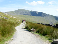
The drying room had done a very good job with my clothes and boots, so I could at least set off with everything more or less dry, and with the weather being beautiful, I might well remain dry all day. There was about a mile to walk along the main road to where the Watkin Path starts its ascent near car parks. The start of this is along a path through the woods that must have been built ten or more years ago, but it is still not shown on the latest O.S. maps. This is presumably a communication problem between whoever built the path, either the Snowdonia National Park Authority or The National Trust, and the county council, who would pass on the information to the Ordnance Survey. It is not uncommon for this to happen. However, it is very unlikely that anyone will get caught out by this as the route is so well laid out and waymarked.
![]()
 Llyn Gwynant from Youth Hostel |
 Start of Watkin Path to Snowdon |
 Watkin Path through Woods |
There were already quite a lot of people making their way up, and even a few coming down, though they may not have come from the summit. A chap in his late 60s was chatting to three other walkers and recounting the time 42 years ago when he and his wife walked up this route on their honeymoon with just a can of coke between them. Needless to say they were parched by the time they reached the summit and were able to get something from the old café there. I recounted my own tale of proposing to my wife on the top of Great Gable in the Lake District 45 years ago, which was the first and the last time that she ever climbed a mountain. His wife and some other family members were booked on the train later on and he had arranged to meet them at the top.
![]()
 Waterfalls on Afon Cwm Llan |
 Watkin Path above Waterfalls |
 Upper Waterfalls on Afon Cwn Llan |
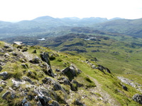
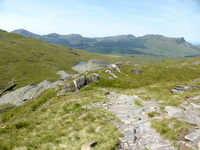
There is a series of waterfalls alongside the route and these were looking magnificent in the sunshine, with quite a lot of water from the fairly recent rainfall. There was hardly any breeze, so it was getting very warm in the strong sunshine, though as we got higher it was not quite as hot and there was a little air movement. As the path became less steep beyond the waterfalls, we stopped beyond the Gladstone Rock for a rest and a chat until I realised that I had passed the place where the Cambrian Way route turns off to head for Bwlch Main. Fortunately I had not come far past the turn off, so I said farewell and went back down to the old quarry workings where there is a bridge over Afon Cwm Llan. The river is often easy to cross at other points, but the bridge ensures a safe crossing whatever the weather. There was a lot of path-work going on, as they are trying to improve the route on the west side of the river up to Bwlch Cwm Llan on the way to Bwlch Main. The Cambrian Way heads up the steep hillside where there is not much of a path. It was not too difficult, but I was feeling a bit weary and finding it somewhat of an effort, probably with a combination of the heat and the previous days' walking catching up on me.
![]()
 Old Quarry with Bridge over River |
 Old Quarry Buildings |
 Work on Path to Bwlch Cwm Llan |
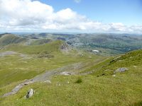
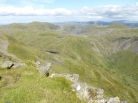
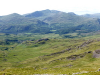
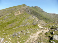
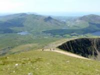
Once on the ridge, it started to get less steep, though it was not until a bit later that it eased off more. There was a complete contrast on this route, with only a handful of people coming and going, unlike the Watkin Path and some of the other popular routes that are teeming with people on sunny days like today. Now that the ridge was not acting as a shelter, there was a cooler and more refreshing breeze, though it did keep coming and going. The views were also getting better, with the summit ahead looming nearer and the mountains and coast to the west in view. The path remained quiet until it was joined by the more popular Rhyd Ddu Path not too far from the summit. I eventually reached the summit at 13.50, which was rather slow going, though I wasn't particularly worried. The summit was swarming with people, as expected but it was possible to go up the raised viewpoint at the top. There was one bank holiday weekend a couple of years ago when there was a two hour queue to get onto the viewpoint. I have been up Snowdon about 30 times, so it wouldn't have bothered me if I couldn't get up there, and I certainly wouldn't have joined a long queue.
![]()
 Yr Aran from Bwlch Cwm Llan |
 Bwlch Cwm Llan towards Beddgelert |
 Bwlch Main Ridge to Snowdon Summit |
![]()
 Old Quarries in Cwm Llan |
 Moel Eilio, Llyn Nadroedd and Llyn Ffynon-y-gwas |
 West to Nantlle Ridge and Mynydd Mawr |
I stopped for a lunch break overlooking the Pyg Track and Crib Goch, still eating up things I had brought from home. This spot reminded me of times when I used to come up with our Jack Russell called Oscar, who died a few years ago. He used to love roaming the mountains with me on day walks, though I never took him on long distance walks because of the practicalities. He was very protective of his territory, which he believed extended to the whole of North Wales including the air space above. When he saw seagulls flying overhead he used to chase after them, racing towards the edge of the mountain close to a 500ft sheer drop, then come to a sudden halt just by the edge. People nearby used to watch on in horror, thinking he was going to fall and meet an untimely end, but he always managed to stop in time.
![]()
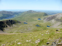 Llyn Cwellyn, Moel Eilio and Anglesey from Snowdon |
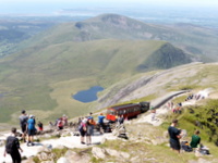 Snowdon Mountain Railway |
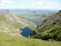 Glaslyn and Llyn Llydaw from Snowdon |
There were various people nearby as I ate my lunch snacks, including a group of three youths who departed after a while. Several minutes later I turned and noticed a wallet on the ground where they had been and, after checking that nobody else around was the owner, I picked it up and looked inside where there were several cards including a provisional driving licence that obviously did belong to one of the youths. I had a look around to see if I could see them, but they must have set off on their way down by then, so I wasn't sure what was best to do. Should I take it to Llanberis and see if there was a police station where I could hand it in, or should I take it to the Snowdon Visitor Centre nearby. I decided on the latter, but there were large queues at all the outlets and I wasn't sure if those serving there would know what to do with it. Then I noticed two Mountain Railway men, who said they operated a lost property service. That made a lot of sense as, if somebody reported it either at the summit or in Llanberis, it could be transported on the next train if necessary.
I had been worrying about how I could manage to take enough food for my stay at Idwal Cottage Youth Hostel to cater for an evening meal, breakfast and a packed lunch, but then I realised how long things had lasted me so far. I had managed two lunches and one evening meal out of the things I had brought from home, and there were still a few things left. This didn't include the sandwiches that I had eaten on my train journey and on my first day's walk, only the other snacks, nuts and chocolate. I had not bought anything else from shops nor packed lunches from B&Bs so far. This meant that I would only have to stock up with about half as much as I had had with me at the start when I visited a shop in Llanberis.
![]()
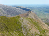 Crib Goch from Snowdon |
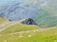 Llechog and Llanberis Slate Quarries |
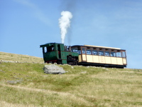 Snowdon Mountain Railway |
![]()
 Llanberis Path down from Snowdon |
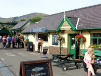 Llanberis Mountain Railway Station |
As I was not particularly pushed for time today, I spent about an hour near the summit, enjoying the splendid views lazing in the warm sunshine until I decided it was about time to move on. Normally, I would have stayed at Pen y Pass Youth Hostel, which is on the route and has the advantage of being nearly 1,000ft higher than Llanberis, thus reducing the amount of climbing the next day. However, the next day is quite a short one with only about 2,500ft of ascent, so it wouldn't be a problem to take a longer route from Llanberis, taking in extra mountains. The Llanberis Path roughly follows the railway and it relatively easy, though very busy, but then so are most of the other routes around Snowdon. I always find that the views from this path are less interesting than from other routes, but then I had already benefited from from the near perfect views earlier on, so it was just a matter of pressing on to my destination.
Eventually, I reached the road into Llanberis and was heading towards the railway station. However, the Youth Hostel is up the hillside above the village, so I had planned to take a short cut involving some footpaths, turning left through a housing estate then along a minor road to where the footpaths started. At first all was well as the path climbed steeply uphill then levelled out where there was another path shown turning to the right, which is the one I wanted. It was quite wide at first as it went past a few houses, but then I was confronted with high barbed wire fences and a gate with a sign saying 'Private - No Public Right of Way'. I wandered back and forth a bit thinking I may have missed the path, but could see nowhere else to go, with all the indications being that the right of way should go through the gate. The only other option seemed to be to go along the fence to the right hoping to see some way around to rejoin the path further along, in case it had been diverted. However, I just got more and more into an almost impenetrable jungle of vegetation and trees, with some patches of boggy ground to add to it all. Any attempt to head towards where my GPS was telling me just met up with more barbed wire fence or impenetrable vegetation. In the end, I just tried my best to escape by whatever means I could and, seeing some large houses further down I thought that I might get through to the road from there.
Of course, access was blocked by walls and fences there as well, but there was a lower one that I was able to clamber over into a lady's back garden and she noticed me from her back door. I apologised for the intrusion, explaining my predicament and she kindly directed me down her driveway and onto the road in the village, where I was able to turn back up the hill on the road towards the hostel. On the way up the hill, I passed the other end of the footpath that I couldn't get to, finding that, although it had a public footpath finger pointer, it was overgrown with little sign of use. This just confirmed my belief in never trusting a right of way in Wales unless there is clear evidence of its use. My problem had been that although the first part of the path was fairly well used, the path turning off was not.
All of this somewhat spoiled a beautiful day and caused a lot of hassle and extra effort when I thought I had only a short way to go. Fortunately, I still arrived just before 6pm and was able to book an evening meal at the hostel at £9.95 for two courses. For the first time in the walk my boots had more or less dried out in the warm sunshine on firm paths, just getting a bit wet again on the struggle with the missing footpath. My left boot was still getting worse with an increasing sized gap in the leather and more loose stitching, but the Gore-Tex was still managing to keep out most of the wet. I washed some of my sweaty clothes, as there was a good drying room again, but decided that I now had enough clean things to last me for the rest of the walk without any more washing.
I discovered that, although there were a reasonable number of people staying in the hostel, I was the only one having dinner. Most others were either self catering or eating in one of the pubs down in the village. My meal was pasta and meatballs with a salad followed by sponge pudding and custard, which was just the right amount to satisfy my appetite. Of course, there was the usual wide selection of bottled beers and other drinks for me to choose from, so I had a couple of local beers as usual. Feeling rather weary, I went off to bed to lie down and rest.
[Index of Walks]
[Previous]
[Top]
[Next]