Pembrokeshire Coast Path 2001

Author: George Tod
This walk is illustrated with photographs. Click on small photo to enlarge in situ, or click caption to enlarge into new window.
Pembrokeshire Coast Path 2001 |
||
|
Author: George TodThis walk is illustrated with photographs. Click on small photo to enlarge in situ, or click caption to enlarge into new window. |
|
| Part 3 - Whitesands Bay to Skrinkle Haven (Marloes) | ||

[Index of Walks]
[Previous]
[Top]
[Next]
[Index of Walks]
[Previous]
[Top]
[Next]
![]()
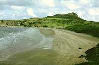 Whitesands Bay and Carn LLidi |
 Ramsey Island from Picrite |
I got up at 7.30 and bought some things for breakfast and packed lunch from the hostel shop - bread rolls, Flora, marmalade, muesli and tuna. I set off at 8.50 in bright and breezy weather, which was fine for walking and the good visibility gave clear views across to Ramsay Island and several other rocky islands. The next few miles of the coast itself is not very spectacular but is more than compensated for by the views across to Ramsay Island. The speed of the current in Ramsay Sound was quite amazing and seemed to flow faster than many rivers. A couple that I met were doing the coastal walk in the opposite direction and had found it very enjoyable so far.
Rounding the headland gave some welcomed respite from the strong northerly wind which was, at least, not as strong as the previous day and seemed to be gradually easing off to the extent that St Brides Bay looked quite calm. The coastline was less dramatic for a while with the best views looking back towards Ramsay Island. There were quite a few people out walking, as this part of the coast is close to St David's. I passed the sheltered little harbour of Porth Clais, which is where many of the walkers were starting from, and stopped for lunch on a headland a little way past the ruins of St Non's Chapel. It was a lovely sunny spot with only a steady breeze blowing and a beautiful view back up the coast.
I set off again after three quarters of an hour at 1.30 p.m. even though I would have liked to stay longer. There were still 10 miles left to walk and I didn't want to be rushing to get to Pen y Cwm in time for dinner at 6.30 p.m. The coastline was more interesting again with headlands and sheltered bays - there was even someone swimming in Caerfai Bay which was well sheltered from the cool wind. In Caer Bwdy Bay there was a fine example of folded rock strata and there were many rocky outcrops with interesting shapes over the next few miles.
![]()
 West from Chanters' Seat |
 Solva from Careg Lyfn |
 Dinas Fach and Newgale |
The coast continues with excellent scenery and a fine view of Solva harbour from the cliff tops and of the coast towards Newgale. At the highest points along the cliffs there are some particularly splendid views back to the west.
Near Newgale there is a sudden change of scenery with a wide sandy beach and fields sloping gently up the hillside in stark contrast to the rugged cliff scenery of most of the route so far. Chimneys from the oil refineries were now quite prominent across the bay, heralding the approach of the industrial areas to come in a few days time.
The weather was now perfect for walking - only a few light clouds in the sky and a gentle cool breeze blowing over the tranquil scene below. There were seabirds drifting to and fro across the bay and a seal diving and swimming underwater across the bay. In the calm, clear water I was able to see the seal quite clearly all the way. A little further along I encountered a grass snake crossing the path just in front of me. It was about a foot long and was dark green with black markings.
Towards the end of the day's walk there were a few steep ups and downs, which are never welcome at the end of a long day. Then came what seemed to be an interminable road walk to Pen y Cwm Youth Hostel, which is in the middle of nowhere about one and a half miles from the village of Pen y Cwm. The hostel has a Wales Tourist Board 5 star rating with excellent facilities but I failed to understand why they chose a location two miles from the coast with nothing of interest in the nearby area and without even a footpath to the coast. It is, however, close to a cycle route, but I suspect that most visitors arrive by car.
The hostel has en-suite showers in each dormitory and there is even a wine list with the evening meal, as well as a choice of filter coffee after the meal for an additional 40p. Dinner was chicken pie and a dessert with raspberry coulli, all served at the tables. I had a carafe of wine with my meal for £2.70.
The YHA seems to have been unsure which direction in which to go over the past few years and this seems to be an experiment in up market hostelling to see if it attracts more people. The old hostels were always aimed at people following outdoor pursuits of walking and cycling and, at one time, hostellers were not even allowed to arrive by car whereas this hostel is clearly aimed at motorists who may or may not be involved in outdoor activities. It is difficult to say whether this is a step in the right direction, but has unfortunately become apparent that some of the smaller hostels with few facilities are uneconomic and many have been closed down. I was sharing a dormitory with a chap from Wolverhampton who was staying for a few nights and doing a bit of walking. He offered me a lift to the Duke of Edinburgh pub at Newgale after dinner and we had some very good Director's bitter. I generally like to do everything on foot when I am on a walking holiday but the prospect of all that uninteresting road walking would have deterred me from going out had I not been offered a lift.
[Index of Walks]
[Previous]
[Top]
[Next]
It was good weather again and I had only about nine miles to do including the walk back down to the coast path, so my plan was to have a leisurely stroll stopping to rest and enjoying the sunshine and the scenery. I rejoined the path at Pen y Cwm beach and then had a short climb over the headland to the vast sandy beach at Newgale, which is two and a half miles long. I ambled steadily along, stopping to write postcards and later to have lunch and do some sunbathing near Rickets Head. Eventually I made my way to Nolton Haven for a pint of Director's bitter at The Mariner's where I first heard the news of the terrible events at the World Trade Centre.
>![]()
 Rickets Head from Nolton Haven |
 Druidston Haven |
Further along the coast there were many signs of landslip with large sections near to the path having sunk down a few feet and others that have sunk much more. In general, this section of the coast has less spectacular cliff scenery than much of the previous walk but abounds in good sandy beaches. By this stage, the coast over by Ramsay Island looked very distant but, from the cliffs near Broad Haven, the oil refinery chimneys at Milford Haven looked very close. They are on the opposite side of the peninsula and two and a half days walk away but, as the crow flies, they are only about five miles away.
I spent a while on the seafront at Broad Haven, as it was still too early to check into the Youth Hostel. There were quite a few people taking advantage of the pleasant sunshine on the beach.
Broad Haven Youth Hostel is quite large, as it is also a field study centre. There were some groups in but they were not dining that evening, so I had dinner of grapefruit, haddock and chips and apple crumble with one other hosteller. The television was on in the lounge, so I watched in amazement for quite some time, film of the World Trade Centre towers collapsing into piles of rubble. Later I went down to the Galleon Inn and had a few pints of Boddington's bitter whilst still trying to comprehend the events of the day.
[Index of Walks]
[Previous]
[Top]
[Next]
![]()
 Little Haven and Broad Haven |
 Marloes Sands |
The weather was reasonable to start with but the forecast was for rain everywhere later in the day. I had breakfast at 8.30 with a party of mentally and physically disabled plus a few others, including a cyclist who was sharing my dormitory, and I set off walking again at 9.30 along the road to Little Haven. Broad Haven has quite a lot of modern development but Little Haven is a far more picturesque little village. From the cliffs there are some good views back into Little Haven and Broad Haven but for some of the way trees block the view. In Brandy Bay I saw three adult grey seals swimming and diving in the sea with three white seal cubs lying on the beach.
By this time the weather had deteriorated and was very grey and dismal, with mist drifting in from the sea, and it was not long before it started to rain making me put on my waterproofs. After about five minutes the rain stopped and, as I was getting wetter from condensation than from the weather, I stopped to take them off again. Even with grey and overcast weather, there was still a lot to see. One of the advantages of a coastal walk is that much of the scenery is at close quarters and still visible in bad weather, whereas on a mountain walk all the scenery can very easily be spoiled or lost by mist and rain. The waves crashing in over rocks and all the little coves and headlands can still be enjoyed to a degree in poor weather as well as the birds and other wildlife.
Around St Brides the rocks are a very colourful dark red. Although there was quite a fresh wind blowing at times, it was from the SW so it was not very cold, unlike some of the chilling northerly winds earlier in the walk. I stopped for lunch at 12.30 by Castle Head, just past St Brides, but there was no chance of any sunbathing, so I didn't stop for long. The cliffs are not very high around this part of the coast but, nevertheless, there is some good coastal scenery made more interesting by the waves crashing over the rocks.
By Martin's Haven the weather turned worse with stronger wind and some rain, causing me to shelter for a while before heading round the Deer Park marine nature reserve at Woolstack Point. This is not actually on the coastal path but is recommended as a detour. Up on the cliffs the wind was tremendous and I had to battle my way along, struggling not to be blown off balance. Despite the worsening weather, there were still some good views across to Midland Isle and Skomer. This area is a prime site for breading seals and I counted twelve in and around the sheltered coves, several of them were on the beaches including at least four pups, the rest were swimming, presumably looking for fish. It was quite difficult trying to count the pups on the beaches because the wind was so strong right in my face that I had difficulty seeing clearly and the motionless pups can easily be confused with white rocks and vice versa.
The scenery around to the south is far more dramatic, made even more so by the stormy weather conditions. It started to turn wet but I didn't attempt to put on my waterproofs as it would have been quite a struggle in the wind, so I just pressed on hoping to reach the shelter of Marloes Youth Hostel as soon as possible. After struggling round the coast for about another mile, I came to a sign for the hostel. It was not the turning I intended to take, as it turned off too soon and would involve some back-tracking later, but with the awful weather my only thought was of getting to the hostel as quickly as possible. Moving away from the coast did indeed lessen the ferocity of the wind, though I was still got quite wet from the rain.
I reached the hostel at 4.35 p.m. and took shelter under cover of some outbuildings waiting for the 5 p.m. opening time. After a short while, a German hosteller came out and told me that the kitchen was open, so I entered and made myself a hot cup of tea, which warmed me up a bit and, after checking in, had a long hot shower, which warmed me up further. The German couple were cooking fish and had more than they needed, so they offered me some along with some toast and salad and that also helped me to recover from the cold. The Germans were not walking, but were touring round the area by car, as were a French couple, who were also staying in the hostel.
After a while, the weather brightened up quite a bit and the wind dropped considerably, so I decided to walk back up the coast to where I had turned off for the hostel. I didn't want to be too pedantic about following the entire route, but this is a very good part of the coast and I didn't want to miss any of it. There was a very fine view looking down Marloes Sands with all the breakers rolling in.
I returned to the hostel thinking that I would buy a few things for breakfast the next day, but found that they had very little in the shop other than beans and cereals. This hostel is manned by volunteer wardens so the shop is not as supplied as well as hostels with a regular warden. I then set off for the pub in Marloes, a little over a mile away. It is called the Lobster Pot Inn and they sold some home brewed ale, which was very good, as well as a beef Madras. Again it was dark for the walk back and I took a slightly shorter route back along a road which was a little further south. It was very dark with a starry sky and a little light cloud, but it was just possible to make out the route without a torch. It was fascinating to see all the stars so clearly as I walked along without the usual glow of street lamps to diminish the view. The Marloes peninsula is very narrow so as I walked to the pub I was within two hundred yards of the coast path on the north of the peninsula.
[Index of Walks]
[Previous]
[Top]
[Next]