The Cambrian Way 2000
Author: George Tod
This walk is illustrated with photographs. Click on small photo to enlarge in situ, or click caption to enlarge into new window.
The Cambrian Way 2000 |
||
|
Author: George TodThis walk is illustrated with photographs. Click on small photo to enlarge in situ, or click caption to enlarge into new window. |
|
| Part 5 - Days 11 to 13 - Devil's Bridge to Dinas Mawddwy | ||

[Index of Walks]
[Previous]
[Top]
[Next]
[Index of Walks]
[Previous]
[Top]
[Next]
The weather was much better in the morning, as I went down to breakfast at 8 a.m., and the forecast was also quite good. My foot was somewhat better, but I would have to see how it fared when I started walking on it. I set off, and within a short distance, it was starting to give me a lot of pain, so I stopped to make a few modifications to my insoles and that made it a lot better. I was now able to hobble along more evenly, with a blister on my right sole balancing out the blister on my left heel! Normally blisters, once burst to relieve the pressure, improve after a few days but the one on my right foot seemed to have gone from bad to worse, with some of the inflammation spreading into my toes.
![]()
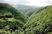 Devils Bridge Gorge |
 Rheidol Valley, Devils Bridge |
To start with, the route goes down into Devil's Bridge Gorge, past the narrow gauge railway, and down to a bridge over the river at the bottom of the gorge. There was a lot of very nice scenery, although much of it was concealed by the trees, and the weather was very pleasant. The route along the gorge had been altered in the guidebook because of a landslide further along, but when I got to the point of the diversion, there appeared to be nothing to prevent me from taking the original route. I took this as I thought that it might offer a better view across to the Devil's Bridge Falls, even though it added about a mile (I must be a glutton for punishment). However, when I checked the mileage of the route later, I found that it had not been altered in the book to cater for the diversion, so I was still only doing the distance that I thought I would be doing in the first place. The view across to the falls, however, is not particularly good, as much of it is obscured by trees, so I would have been just as well saving my feet from the extra distance.
I passed the Youth Hostel at Ystumtuen, which had recently been closed, like may other small and uneconomic hostels. This is most regrettable for walkers, as it makes it much more difficult when trying to plan routes using as many youth hostels as possible - what with closures, and hostels full with school parties, it is very difficult to use many hostels at all.
After a stretch of road walking, a path cuts off the corner towards Ponterwyd but, because of the usual lack of marking of footpaths around here and because of a rather confusing sketch map in the guide book, I missed it and took the road route, which adds about half a mile. As I joined the main A44 road into Ponterwyd it was very busy with weekend traffic, which made walking rather unpleasant in places, with traffic whistling narrowly by, so I was very pleased when I reached Ponterwyd and was able to cut off along a path and then down a minor road towards the Dyffryn Castell Hotel. All around this area there are numerous waterfalls, some of them spectacular and others smaller, but still attractive. I had to rejoin the busy A44 again for a short way but soon reached the Dyffryn Castell Hotel, where the path to Plynlimon commenced.
As I started off up the path above the hotel, it was a convenient place to stop for lunch, and I ate my ham and tomato sandwiches and bara brith, which I had got from the Devil's Bridge Stores. The weather was very pleasant for walking with light cloud and quite a bit of sunshine, but with a cool breeze. The ascent of Plynlimon was steady and quite well defined after a poorly defined start. There were good long distance views all around and, just before the summit, the view to the west suddenly opened up to reveal marvellous views of the Nant-y-moch Reservoir and the coast which looked surprisingly close, although it was still about twelve miles away. From the summit, the whole panorama opened up, with views of Cadair Idris and Snowdonia to the north, and the Black Mountains and Brecon Beacons to the south.
![]()
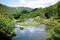
 Dyffryn Castell Hotel and view South |
 Nant-y-moch Reservoir and coast |
 Source of River Severn |
There was a very strong wind at the summit, so I sheltered in the cairn for a while. A couple of walkers arrived having walked from Dylife, taking five hours. As it was already 2.45 p.m. I hoped that it would not take me quite as long to get down there as it had taken them to come up. I made my way along the ridge, but was looking for the short detour to see the source of the river Severn. Seeing some white marker posts, I assumed that these may be pointing the way but, alas, after following them for quite a way, they led me somewhat off my route and I then had to make my way across rough moorland to regain the route to Dylife. On the way I stumbled by accident across the huge wooden posts, one in English and one in Welsh, marking the source. I then had to make my way across some very rough and boggy ground, eventually reaching a track near Bugeilyn lakes. I was heartily glad to set foot on a nice solid path but, after following it for about a mile, the route went off again over rough moors overlooking Glaslyn, which is a nature reserve, before dropping down over very boggy ground towards some of the old mine workings and thence on a better path into Dylife. Some of the scenery around there was impressive with very steep sided valleys and many remnants of the bygone era when it was obviously a hive of mining activity.
![]()
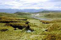 Bugeilyn and Snowdonian mountains |
I arrived in Dylife at 6.50 p.m. as the good weather started to give way to rain, but there was not much of this before I was safely inside the Star Inn, my home for the night. It had been quite a hard day's walk, though very pleasant in the fine weather, but I could have done without my rambling detour trying to find the source of the Severn which must have wasted quite a bit of time and effort.
After resting my weary feet, I went down into the bar for a meal of very good cottage pie with some Marston's Pedigree Ale. The bar was very busy, as the remnants of a funeral party were still there - there had been a hundred in there earlier in the day. However, the service was very efficient, considering how busy it was, and it did not take them too long to serve my meal.
[Index of Walks]
[Previous]
[Top]
[Next]
The rain had gone by the morning and the weather was reasonably bright but windy. I had breakfast at 8.30 and got some sandwiches for lunch with no hurry as I had only ten miles to walk that day. I had debated, when planning the walk, as to whether to do the stretch from Dylife to Dinas Mawddwy all in one day. I was now heartily glad that my wife had persuaded me against it, as I was really in need of some easier walking so that my feet would have chance to recover a little. At least the modifications to my insoles were working quite well, and the blister on my right foot, whilst not yet better, was no worse and was showing some signs of healing over.
![]()
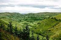 East from Bwlch Glynmynydd |
I had a steady morning's hobble through some very pleasant countryside, with lots of rolling hills and with views of some of the higher mountains in the distance to the north. I had a few of the usual problems with route finding in places, although I never went too far off track, as I had plenty of time to stop and study the maps. There was a very cool north westerly wind blowing, but otherwise it was fine and sunny, and I managed to find a nice sheltered spot by the forest at Bwlch Glynmynydd to stop for lunch. The wind was whistling through the trees, but I was sunbathing with hardly a breeze for over an hour, by which time thicker cloud came along. The weather stayed fair to Commins Coch and up to my B&B at 'Gwalia', a mile and a half up the hill.
This B&B is vegetarian and was not my first choice, but it was conveniently near to the route, so I decided to give it a try. It was run by a couple who have a very high degree of self-sufficiency, with a goat and hens, and a considerably sized vegetable patch, as well as a large greenhouse. Virtually everything is home-made, and I had an interesting dinner of spaghetti, lentils, roast nuts and an assortment of other things, followed by rhubarb crumble with yoghurt. A couple from Worthing were staying there and I spent a pleasant evening chatting to them by a cosy wood fire.
[Index of Walks]
[Previous]
[Top]
[Next]
I started the day at 8.45 with a breakfast of muesli, toasted home-baked bread, and a boiled egg, eventually getting off for a rather late start of about 10 a.m., as I had only 12 miles to walk and the weather was rather damp and misty. My boots had, for once, fully dried out, having had very little bog-hopping the previous day, so I was able to give them a good waxing in the hope of keeping my feet dry for longer.
Climbing up to Mynydd y Cemaes with its vast wind farm, I was soon up into the cloud. At the top it was just a matter of following the access road along through the mist. The wind powered generators could be heard by their swishing and humming sound before their shapes came looming into sight. There was a very strong wind blowing, so the generators were probably running flat out, though several were locked in their parked position, which is done, either for maintenance, or when the wind is too strong for safe operation. It was a little frightening walking past the rapidly rotating blades, although I don't think there was any real danger of them flying off, though it has been known to happen. After the long line of more than twenty generators, the access road ended and I was back to squelching through wet grass and boggy ground along what are supposed to be footpaths in these parts.
After a while I found an extremely rare thing - a waymarked footpath. However, the waymarking ended where it was needed most and it was then back to heading in the right general direction, hoping to find some identifiable landmark. It took a little while for me to find my bearings, but eventually I found the main track around the hillside leading to Mallwyd and the Brigands Inn, where I was just in time to have a pint and a packet of crisps and some shelter from the drizzling rain which had persisted all day. I had kept on walking constantly, apart from a short lunch stop, as there had been no real place to shelter, so I had made good time and had only another two and a half miles to walk.
I arrived at Dinas Mawddwy by 4.30 p.m. and was taken by the large areas of pink rhododendrons on many of the hillsides adding a splash of colour to the scenery. I was staying at the Red Lion, which was not yet open, so I waited for a while on a seat outside where it was cool, but not actually raining any more.
After settling in, I had a bar meal of Welsh lamb and leek pie with chips and a few pints of Bass. My feet, particularly my right foot, had been quite good for most of the day but were hurting a bit by the end. It always makes matters worse when my feet get wet, which was happening quite a lot on this walk. My boots were nearing the end of their life, having done about 1,100 miles before the start of the walk, so they let in more water than usual, but even new boots let in water eventually when faced with constant soaking from wet grass and boggy ground.
[Index of Walks]
[Previous]
[Top]
[Next]