Price comparison - multiply by 2.76 for 2023 equivalent
The Westmorland Heritage Walk was devised by Mark Richards and Christopher Wright and first published in 1987. It is an attempt to approximately circumnavigate the old county of Westmorland and, in doing so, take in some of the best scenery that Westmorland had to offer. It, therefore, does not stick strictly to the borders, but deviates, where appropriate, to take in some of the best viewpoints. The walk has no official status and, to date, has not received any wide publicity to bring about much degree of popularity, although it certainly rates highly in terms of scenery when compared with many official walks. There are several places where there are optional high or low level routes to cater for the weather and/or the relative fitness of the walker. I set out with the intention of following all the high level routes as I always feel that this gives the best views, if the weather permits. By taking all the high level routes, the walk measures 200 miles on the map and considerably more on the ground when all the twists and turns of the many steep paths are taken into account. The total amount of climbing, if all the high level routes are taken, is in excess of 33,000 feet, which is a little more than the Pennine Way but in a shorter distance. It is, therefore, not a walk to be undertaken by the fainthearted, although there are several low level alternative routes available.
For accommodation, I attempted to use Youth Hostels as much as possible because they are cheaper than bed and breakfast accommodation and also offer better facilities and a friendly atmosphere for walkers. For the nights when Youth Hostels were not nearby, or were closed, I booked bed and breakfast, and in one case, a Dales bunkhouse barn.
As the walk is a circular one, I decided to start at Kirkby Lonsdale, rather than Arnside, so as to take advantage of the Youth Hostel at Arnside. I left my car parked at Kirkby Lonsdale and was thus able to get to the walk and return from the walk on the first and last day without incurring any extra overnight accommodation costs. The walk was planned to take 13 days, with accommodation required for 12 nights.
The route follows existing rights of way although some of these are not very apparent on the ground. Because this walk has not gained a popular following, there are many places where footpaths are overgrown or difficult to find, whereas on the more popular walks, an army of boots have cleared a very distinctive track. The chances of meeting anyone else who is doing the walk are also quite slim and even the chance of meeting anyone who has even heard of the walk is very limited; I met three throughout the whole walk. However, many sections of the walk follow routes which are already popular locally, particularly in the Lake District, so there are a number of other walkers around. In other parts, though, it is possible to walk for hours without seeing a soul, even on a sunny Sunday afternoon. Most of the route avoids particularly boggy areas and I found it possible to walk the whole route without the use of gaiters, although perhaps the place they may be needed most is, not for boggy areas, but for walking through long wet grass in meadows.
Preparation
I set out on this walk having done no training, as such, although I had kept reasonably fit by doing a good long walk every few weeks through the year, but without a heavy pack.
Planning and organising this walk was not too easy in some parts, as there are some stretches which do not have much accommodation for considerable distances. It was also made more difficult by the lack of an accommodation guide, although I believe that one has now been put together. Fortunately, there were several Youth Hostels on the route, but other bed and breakfast addresses had to be searched out from a number of other published accommodation guides.
The main consideration in planning each day's walk was to keep the distance to less than 20 miles unless walking over easy terrain, although this was not possible all of the time, with one day having a walk of over 25 miles, starting off over several Lake District fells. In two cases, where the day's walk was in the form of a loop, I found it advantageous to stay for two nights in the same place. This meant that I could carry a light pack for the day, which more than compensated for the few extra miles of low level walking which I had to do to get back to my starting point of the day.
Planning, Equipment & Accommodation
Equipment for the walk was based largely on the same list as I had for previous walks and which I had found to be satisfactory. I did all the walking in shorts to avoid having to carry an extra pair of trousers for walking. The total weight of the rucksack finally came to 15 lbs plus food and drink for each day of up to 7 lbs.
For route finding I managed mainly with the guide book of the walk, but did also take a 1" O.S. map of the Lake District and some sheets from an O.S. road atlas showing the overall route. To make the route easier to follow in the guide book, I went over it with a highlighter pen. I also marked mileage along the route, as this gives a very good indication of progress through the day and makes it easier to set the appropriate pace to arrive at the accommodation in time. I always tend to plan the pace of my day's walk backwards, in that I decide what time I need to arrive at my destination and then set my pace and length and number of stops accordingly.
The main difference in equipment from that on the last two years' long distance walks, was a pair of new 'Daisy Roots' boots, which I bought at the beginning of the year to replace my Hawkins boots, which had split where the leather joined the sole. Although I had gone through the painful process of breaking them in already, they suffered from another problem which only really became apparent as I got started on the walk, and which caused me a lot of discomfort for a considerable amount of the walk. The boots have a hard, flat, plastic sole inside, with only a rather thin insole, as standard. I had noticed that the balls of my feet tended to feel rather hot and tingly when wearing them for day walks, but this never caused any real problem. Nevertheless, I thought that they would have benefited from some thicker insoles, but when I tried putting some in, I could hardy get the boots on my feet, so abandoned the idea. However, with the extra weight of my pack, and with the continual walking, the pains in my feet started to build up to the point where they were unbearable. I eventually decided that I would have to have some insoles, even if this made my feet cramped. Once I had bought these and walked with them for a while, they moulded to the shape of my feet, which spread the weight over a larger area and made them much more comfortable. Although my feet were cramped when I first put in the insoles, this was soon alleviated when they had had chance to bed down. Having already got my feet into a very tender state, however, it took some days for them to get back to a normal level of discomfort. It was only for the last few days of the walk that I felt at ease with my feet, and it was several days after the walk before I could sleep well at night without being troubled by aching feet.
The one thing that I decided to do this time was to avoid Youth Hostel packed lunches, which I generally found to be very uninspiring and poor value for money. With some walks there are so few shops in places that it is not very easy to find any alternative, but this route passes through quite a few towns and villages, so it should not be a problem.
All the accommodation was pre-booked, as were meals, where required. In some places, I did not book dinner, as I was not sure if I would get there in time after a long day's walk.
Day 1 - Sunday 20th June 1993 - Kirkby Lonsdale to Sedbergh via Calf Top
Distance: 14 miles
Accommodation - Catholes Farm Bunkhouse (Dales Barn) �4.50, bed only
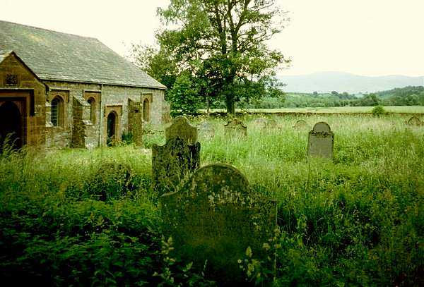
I set off from home at 8.15am by car, arriving at Kirkby Lonsdale at 10.00am. Looking for a place to leave the car, it did not seem very promising anywhere in the town, as it has very narrow streets with lots of double yellow lines. The Devil's Bridge car park, just out of town, had plenty of space and was alright for free long term parking, except that it did not look too good from the security point of view. I left the car there and called into the Tourist Information Office to see if they could suggest anywhere better. The lady there said that the Devil's Bridge car park was as good a place as any, but that it may be a good idea to leave a note at the Police station so that they did not think that the car had been abandoned. She gave me a piece of paper and I wrote down all the details and posted it through the Police station letterbox, as it was closed at the time.
River Lune from Ruskin's View
Devil's Bridge, Kirkby Lonsdale
The time was now 10.30am and I started on the walk proper, going to Ruskin's View by the river with the weather pleasant for walking - some cloud with sunny spells. By 11am I got back to where I had started from, at Devil's Bridge.
The next few miles were across farmland, with the path often quite difficult to find, but with the walking quite easy and fairly level. The ascent to Calf Top gave some fine views across to the Lake District and coast with the weather still pleasant, but with a cool wind at the top. I had lunch at 2pm on Castle Knott. The views are marvellous with a panorama taking in the Lake District fells, the Howgill fells, Dentdale and Morecambe Bay. On the whole of the walk over the hills I didn't see another soul, and that was on a fine Sunday afternoon.
Eden Valley & Lake District from Eskholme Pike
Dentdale from Combe Top
I arrived at Catholes Barn, which is a Dales Barn, not far off the Dales Way, offering similar accommodation to a Youth Hostel but with only self-catering facilities. I discovered that I was the only person staying there, so I would at least be assured of a peaceful night, albeit a lonely one.
As I was not geared up to self-catering, I set off, after a shower, into Sedbergh which is just over a mile away. After phoning home, I found a pub selling bar meals and had Cumberland sausage and chips for �3.95. There were quite a few walkers in there, mostly doing the Dales Way, including two old dears of about 70 who had done the Pennine Way 11 years ago, with all the camping gear, in 14 days. They were doing the Dales Way in 6 days and had two more days to go, although this time they were staying in bed and breakfast accommodation.
The first day tends to be a bit hard going, getting used to carrying the weight of the rucksack. My feet were rather sore with some small blisters on the heels. It was just as well that it was only 14 - 15 miles, although I could have managed more after a rest.
I walked back from the pub by the side of the river, which was very pleasant except for the large number of midges.
Day 2 - Monday 21st June 1993 - Catholes to Ellergill via Howgill Fells
Distance: 15.5 miles
Accommodation - B&B, Ellergill Farm - �22.25 with full meals and packed lunch
After another good night's sleep, I had breakfast at 8.30am and set off at 9.15am. The weather was rather cloudy and the forecast said that some rain was possible, with brighter weather coming later. In an effort to improve the state of my feet, I folded up some towelling socks and put them under my instep to help to spread the weight a bit more. I felt a lot fitter than on the previous day, and think that I must have been fighting off a bug earlier on.
Calders from Arant How
Cautley Spout from Yarlside
I was starting to find it a bit hard going, with sore feet and with a general lack of energy, so I started off taking it steadily with plenty of rests. There were fine views again, as even though there was not much sun, there was very clear visibility. There were also a few more people around, but not very many; I met about half a dozen over the fells all day. From the fell tops it was possible to see Cross Fell quite clearly, whilst still having a good view of the Lake District fells and Morecambe Bay. There was also a good view of the Three Peaks to the east. Progress was quite slow as there were several steep climbs between the various fells and I was still lacking in energy, so I started to wonder whether I would make it to the B&B for 6pm as I had said when I had written to them. As the day went on, however, I began to feel less lethargic and was able to press on at a better pace, although I was still having problems with my feet so, when I reached the road near Ravenstonedale, I changed into trainers to try to relieve the pain that my boots had been causing. The problem arose because all of the weight was being taken on small areas on the balls of my feet and my heels.
I was not sure whether I would be able to telephone home from the B&B, so I tried phoning from Ravenstonedale, forgetting that the family would all be out taking my younger daughter Jennifer riding. I pressed on to Ellergill, arriving at exactly 6pm. There was a good evening meal of soup, beef casserole and custard pie. The only others staying there were a couple from Warrington who had been several times before and who used it as a base for sightseeing.
Ellergill is a rather remote farmhouse, in that it is quite a distance from the village of Ravenstonedale, but it was in a convenient place to minimise the rather lengthy walk of the next day.
Day 3 - Tuesday 22nd June 1993 - Ellergill to Kirkby Stephen via Wild Boar Fell, Mallerstang and Nine Standards Rigg
Distance: 20.5 miles
Accommodation - B&B, 'Lockholme', Kirkby Stephen - �14.00
After another good night's sleep, I had breakfast at 8.30am and set off at 9.15am. The weather was rather cloudy and the forecast said that some rain was possible, with brighter weather coming later. In an effort to improve the state of my feet, I folded up some towelling socks and put them under my instep to help to spread the weight a bit more. I felt a lot fitter than on the previous day, and think that I must have been fighting off a bug earlier on.
Yoadcomb Scar from The Nab
There was a steady climb up to Wild Boar Fell, partly over open moorland, but the going was not bad underfoot. I reached the summit at 10.30am and there was some thick cloud and a few spots of rain, but with brighter weather coming in from the west. However, the visibility was still good except for around Cross Fell which was covered in cloud. I could still see Morecambe Bay, the Lake District and the Three Peaks. The weather was improving all the time and became very pleasant at Aisgill Summit, giving magnificent views down the Eden Valley with Wild Boar Fell to the left and Mallerstang to the right. At Aisgill there is a lovely waterfall, Hellgill Force and the route then leads up the hillside to a grassy lane which makes for a very good walking pace. It was surprising that, even though I had been walking at a much faster pace, helped by the padding in my boots, I was still only averaging just over 2mph including stops and photographs. I reached Mallerstang at 1.50pm. with 10.5 miles to go, but with the biggest proportion of the climbing done.
Hellgill Force
Hellgill and Hellgill Crags
By this time, the best part of the weather had gone - looking over towards Nine Standards Rigg, the sky was very threatening, although the Howgills were still bathed in sunshine. It started to rain at High Pike, so I put on my waterproofs and walked on through drizzle all the way to Jack Standards and then through thick mist over to Nine Standards Rigg. At Nine Standards Rigg the visibility was so poor that it was only just possible to see all nine cairns at once. It was a contrast from last year, on the coast to Coast walk, when it was a beautiful sunny day with good views all around and walkers sunbathing at the summit. There was some heavier rain as I dropped down from the summit but this eased off and the mist cleared on the way down to Kirkby Stephen.
My feet were getting very sore, made worse by the descent from Nine Standards Rigg and, after one or two short rests, I arrived in Kirkby Stephen at 7pm. I asked someone where South Road was and set off in that direction looking for number 48, but when I found it it did not have the right house name of 'Lockholme', and when I looked around I found that I was in High Street. I returned to the town centre and asked again, only to find that South Road is an extension of High Street and that the numbering starts again, so I eventually arrived at the B&B at 7.20pm. I had a bath and a cup of tea and rested my feet for a while before setting off into town to find something to eat. I passed two pubs advertising bar meals, although the two fish and chip shops were closed, as was the Chinese Take-away, so I called at the phone box to phone home first, before going for a pub meal. When I returned to the first pub, the White Lion, the food sign had gone in and I noticed that it said that bar meals were available only until 8.30pm. The second pub, a hotel just up the road, which was still proudly proclaiming bar meals from 6pm onwards, on boards both outside and inside the pub still looked a good bet. I went in and ordered a pint, with difficulty, as there were a crowd of locals engulfing the bar centred around someone who looked like the local squire. The landlord seemed to be ignoring anyone else, so I had to shout my order across the group of them. I then asked if they were still serving bar meals which received a surly "NO" with no explanation as to why they were still being advertised all around. One of the group around the bar mumbled "You can have a mud pie if you like" in a sarcastic tone, so I took my beer away to a table and sat down - it wasn't even very good beer, so I soon departed from the inhospitable establishment.
I went back down to the White Lion, knowing at least that it was more friendly and had good beer, having been in there the previous year on my coast to coast walk. I enquired about food on the off chance that they might have something and had a much more obliging response. They had finished hot meals and his wife had gone to have a bath, but he did have a few pork pies at the bar, so I settled down to a much better pint of beer and a couple of pork pies. The White Lion is normally quite popular with Coast to Coast walkers, but there were none in that night. Most people set off on the walk at the weekend, and reach Kirkby Stephen by the following weekend, so midweek there tend to be very few passing through.
Day 4 - Wednesday 23rd June 1993 - Kirkby Stephen to Dufton
Distance: 19.5 miles
Accommodation - YHA, Dufton �13 - B&B plus dinner
I had breakfast at 8am and found the first person so far who has heard of the Westmorland Heritage Walk. The landlady had actually got a photocopied sheet about it from the Tourist Board and had even been persuaded to pay �10 to advertise in an accommodation guide which was being put together. She was rather keen to know if the walk was going to take off in popularity but I had to sadly inform her that the lack of interest or knowledge about it so far didn't make it likely.
I set off at 9am to buy a few things from town before setting off on the low level walk to Dufton. The route was not the easiest to follow at first, with some of the paths overgrown with nettles and others through soaking wet long grass (there had been a heavy downpour early in the morning). The routes across farmland were often poorly marked needing very careful attention to the map.
After only a mile or two my feet were killing me, so the only thing I could think to do was to fold up another pair of walking socks and put one in the base of each boot. It was difficult squeezing my boots back on and my feet were rather cramped up, but at least it did ease the pain in the soles of my feet.
The first part of the walk did not provide many interesting views, although there were a few pleasant walks by the banks of streams. The weather was also rather dull and overcast but started to improve around Brough, where the route and the scenery also took a turn for the better, with a good view of Brough Castle and views across to Warcop Fell and beyond. I stopped for lunch at 1.15pm, just before Warcop, at a pleasant spot above the river Eden looking across to Warcop Fell and set off again after 20 minutes as there was still quite a way to go.
The afternoon's walk was a considerable improvement on the morning's, going through some very pleasant woodland by the river near Great Ormside, and alongside the river into Appleby. Appleby is a delightful little town with a picturesque main street looking down to the Church at the bottom, with ornate sundials on high columns at the top and the bottom of the street.
The Market Town of Appleby
Dufton with Dufton Pike and Great Dun Fell
After all the problems with my feet, I decided that a good pair of insoles were called for, so I had a look around Appleby for some. The only ones I could find were �3.99, but they were very thick ones and just the thing I was looking for, so I decided that the relief I would get would be worth it, even if they were overpriced. Certainly the folded up socks in my boots had spread out the pressure on the balls of my feet and the heels even though the extra bulk had caused a bit of discomfort.
I resumed the walk without putting in the insoles as I thought that they might have to be cut to size, which would be better done when I reached the hostel. The Cross Fell range became steadily more prominent with the 'golf ball' radar station on Great Dun Fell clearly visible, as well as High Cup Nick. The final half mile into Dufton passed through lovely woodland beside Dufton Gill and emerged into the centre of the village not far from the Youth Hostel. By this time the weather had become bright and sunny to give a very pleasant end to the day.
The Youth Hostel is a very good one, nicely fitted out with a tidily kept garden at the back and with a friendly warden. It is also very central, being right opposite the village pub. It was nice to be in a hostel instead of B&B, as there was a much better atmosphere, with several other walkers who were mainly doing the Pennine Way. Three of them were Dutchmen who, having tired of the Dutch mountains (maximum altitude 50 metres), were trying out the English ones. Another chap, on his own, was doing the final leg of a four-year traverse of the Pennine Way, having done three other sections in previous years.
Dinner was soup, turkey hotpot and jam sponge and just on dinner time a large group of Pennine Way walkers came in, still in their walking clothes. They were walking with the backup service of a bus which ferried them to the nearest Youth Hostel which could accommodate them from wherever they had got to each day. In this case they had come from a little way past Baldersdale. Some of the party were quite old, with one of their members being 75 and apparently one of the fittest.
Later on in the evening I went across to the Stag Inn and met some of the others in there. Unfortunately, I did not get a good night's sleep as the three Dutchmen were up in turns, at about half-hour intervals through the night, going to the toilet.
Day 5 - Thursday 24th June 1993 - Dufton to Dufton via High Cup and Cross Fell
Distance: 19.5 miles
Accommodation - YHA, Dufton, �13.00 B&B plus dinner
I had breakfast at 8pm and started out at 8.45am on a lovely sunny morning, but with some haze. I had made the day's walk into a round trip as the route, after going over the fells, comes to within three and a half miles of Dufton again, before heading for Penrith. By returning to Dufton, I could carry just a light day pack, which made the walking much easier, and compensated for the extra distance I had to walk, all of which was all along relatively flat low level paths and roads.
High Cup Nick
Little Dun & Great Dun Fells from Cross Fell
The insoles fitted perfectly in my boots but, as expected, my feet were very cramped, which made them quite uncomfortable, but this was still preferable to the nauseating pain which I was getting without them. The weather started to cloud over on the walk up to High Cup, although there was still a bit of sunshine when I got there to give an impressive view. The walk up to Great Rundale Tarn and onto Knock Fell follows a very scant and, in parts, non-existent footpath, at first by a stream, but later across open moor with peat hags and groughs. This made the going a little slow, but it was not too difficult nor too boggy. The cloud grew steadily thicker and lower, at times covering the tops of the fells and giving a few spots of rain, but then cleared up considerable to allow a moderate view of the surrounding landscape.
On the top of Cross Fell, by the summit wind shelter, I got mugged by a sheep looking for food - I think it must have remembered me from two years ago when the same thing happened. It is quite funny to see sheep behaving in this way - first of all they look on rather cautiously from a distance, then gradually move in closer and closer whilst still treading their ground very carefully but then, as they move in very close they get bolder and more determined and start nosing at sandwich boxes and anything else that may be edible. At this point it is very difficult to get rid of them and the only thing to do is to pack everything up and move away.
The new insoles started to bed in and my feet had a little more freedom of movement. I only saw a few walkers, mainly because of timing; most of the Pennine Way walkers would have been clear of the fells by the time I got there via High Cup, and the ones coming to High Cup would arrive later in the day. The views were not nearly so good as two years ago when I was doing the Pennine Way, but at least I was not engulfed in mist. On the descent from Cross Fell the weather improved, and the sun was shining over the distant Lake District fells.
I got back to the hostel at 6.05pm with the usual aching feet. Having three long days in succession was not a very good idea, but I did not realise that I would have so much trouble with my feet when I was planning the walk. The trouble was that, even though the insoles were helping quite a bit, my feet were very sore from earlier on and really needed more rest. The trouble with doing walks of around 20 miles is that there is very little time for long rests if you want to do the walk between breakfast and dinner and want to get back in time for a shower and to phone home before dinner.
Dinner was soup, spaghetti bolognese and rice pudding. There were not as many Pennine Way walkers as on the previous day. One poor chap in the party who were bussed in yesterday, slipped in the shower and hurt his foot and didn't think he would be able to walk again for a few days. He was staying on at Dufton until the others get there again for real and, even then, he was not sure whether he would be fit to walk for a few days after that. He also had to clear out of the hostel between 10am and 5pm each day and, as he could only hobble around, was rather limited as to how he could pass his time away. He could just about make it across the green to the pub, where he could drown his sorrows and while away a few hours. The only other Pennine Way walkers were a German woman of about 60 from Hamburg who was walking on her own but who had met up with an English woman artist of about 30 who was also on her own. They decided to team up together for the rest of the way. The rest of the hostellers were mainly cyclists with the exception of one couple who had been spending a few days walking in the area. I met them later in the evening in the pub along with the chap with the injured foot.
Day 6 - Friday 25th June 1993 - Dufton to Penrith
Distance: 16 miles
Accommodation - B&B, Glendale, Penrith - �16
I set off for a leisurely start at 9.25am after breakfast at 8am with only 16 miles to do, mainly on the flat. I had washed out just about all the clothing I had and most of it was just about dried out after being spin dried and having spent two nights in the drying room. The trouble with the drying room was that there was only a cold blower running in there.
The weather was rather cloudy, some of it being low enough to cover the tops of the fells. However, low down it was fine and all of the day's walk was at low level. I retraced yesterday's steps for three and a half miles to Milburn and then continued along the route, much of which was along minor roads to begin with. By adopting a steady trudge I minimised the problems with my feet. This part of the walk was not very interesting apart from a few places where it went away from the road. The only bonus was that it was easy to clock up the miles, which meant that there was plenty of time for rests to help my feet. I reached the half-way point at just after noon and sat by the weir at Acorn Bank airing my feet whilst I had lunch and rested for an hour.
The weather was still overcast but the cloud had lifted from the Cross Fell range giving quite a good view of them and also the northern Lakeland mountains. There was a very nasty mile of road walking along the busy A66 which, at this point is rather winding with little or no verge. There were large numbers of juggernauts rushing by, only inches away, with perpetual gushes of wind from their slipstreams. Eventually the route went off down a side road and then off down a track to St Ninian's Church, which stands a fair distance from any population, by a bend in the river Eamont. The churchyard was very overgrown but services are still occasionally held there, the church being maintained by the Redundant Churches Fund. It is in a very quiet and secluded spot and was an ideal place to stop for a rest as it was 3pm and there was only just over 4 miles to go.
St Ninian's Church with Cross Fell in far distance
The Ruins of Brougham Castle by the River Eamont
After another mile along the A66, although this time on a wider, straighter stretch with better verges, the route turned off to follow the river by Brougham Castle, which made a pleasant change. The route continued by the river to Eamont Bridge, where I then turned off to go along the busy A6 into Penrith to the B&B near the town centre. I settled into the B&B, had a bath and then went out to find something to eat. There were plenty of places around but I settled for fish, chips and peas from a place near the town centre. The weather took a turn for the worse so I went to a supermarket to buy a few things for lunches and then returned to the B&B to watch television, as there was a set in my room.
Day 7 - Saturday 26th June 1993 - Penrith to Patterdale via Place Fell
Distance: 15.5 miles
Accommodation - YHA Patterdale - �14.50 B&B plus dinner
I had a good breakfast at 8am and set off, after buying and writing a few postcards, at 9.30am. The weather forecast was not very good - cloudy with drizzle so it was just as well that the first part of the walk was at low level. I retraced by steps along the A6 to Eamont Bridge and then rejoined the path by the
river. It is hard to believe that the narrow bridge, with traffic lights controlling alternate one-way traffic, was once the main road route to Scotland from the western half of England.
One or two mishaps in map reading caused a bit of extra walking, but for the first time I was able to walk along without my mind being focused on the constant aching from my feet. They were now more as I would expect them to be - a bit tender, but not a major problem - it makes such a difference to the enjoyment of the walk. I stopped in a field near Tirrill for elevenses, but had to move on rather swiftly as a group of inquisitive calves surrounded me and then followed me up the field. When I emerged from the field onto the road, I was not quite sure whether I had come out onto the road in Sockbridge or Tirrill. I asked a woman which village I was in and she proceeded to confuse me by one of those "Well! - strictly speaking this side is Sockbridge and this side is Tirrill..." sort of statements and, not being able to tell me where I was on the map, proceeded to point me up the road in the opposite direction from the way I should have been going. After a while I realised, so decided to cut across some fields to take me back where I should have been. After a few more encounters with over-friendly calves, I eventually got back on the right track.
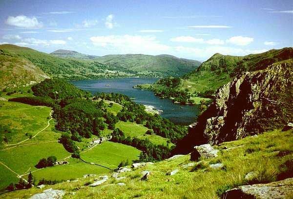
After a little bit of climbing I eventually got onto High Street, the route of the old Roman Road, with a lovely view over Ullswater, albeit with a lot of mist and cloud hanging over the fells. However, there were actually a few patches of sunshine forming here and there even though the general outlook wasn't very good. It was 12.15, so I stopped for lunch with just over 10 miles to go and plenty of time to take it steadily. However, it was a bit cool and windy for hanging about for long rests without good shelter, so I moved off again at 12.40 on a steady descent towards Ullswater. After a while I suddenly realised that I didn't have the book of the walk with me and that I must have left it where I took the last photograph. I ended up having to go back three quarters of a mile and up about 300 ft to retrieve it, although at least I didn't have to carry my pack with me. I actually trotted and even ran a little of the way without any unpleasant sensation from my feet!
The weather had improved to the extent that a lot of the mist had cleared and, although there was still thick cloud about, it was at about 2500 ft and above the summit of Place Fell, which was the highest point of the day's walk.
Ullswater from Place Fell
Brothers Water from Place Fell
After a pleasant little walk by the edge of the lake, I started the ascent of Place Fell and the weather really did me proud - the cloud started to clear and, by the time I reached the summit there was a clear blue sky with breathtaking views of High Street, Brother's Water and Grisedale even though it was a struggle to stand up straight in the wind. After admiring the views for a while, I dropped steeply down into Patterdale, which I could see below with a bird's eye view.
Glenridding from Place Fell
Patterdale
I arrived at the Youth Hostel at 6pm and had a dinner of soup, mince stew, and peaches and ice cream. There were several groups of walkers and the inevitable school party, although the children were very well behaved and quiet at meal times.
After a stroll around later, I called in the pub and met three of the chaps sharing the same dormitory. They were doing three days of the Coast to Coast walk in a long weekend. The pub was very busy even though the prices were very steep, with Boddington's costing �1.50 a pint.
Day 8 - Sunday 27th June 1993 - Patterdale to Grasmere - via St Sunday Crag and Fairfield
Distance: 8.8 miles
Accommodation - YHA Thorney How �13.60 B&B plus dinner
I started to get up a bit before 8am and was taken by surprise, as breakfast was at 8am, not the usual 8.30am, so I had to rush along to avoid being late. I got off to a leisurely start with the weather beautiful and starting to get quite hot even at 10am so off came my tee shirt, especially with some steep climbing to do. I missed the path up St Sunday Crag, so had an even steeper climb up the steep crag side to regain the route. The rest of the ascent was quite steady up to the summit of St Sunday Crag, but with a steep climb up to the summit of Fairfield.
Ullswater from Harrison Crag
Grisedale Tarn from St Sunday Crag
Fairfield from St Sunday Crag
The views all around were marvellous, and I was taking it very steadily as there was very little distance to cover. At the top of Fairfield, Windermere and Coniston Water came into view as well as the coast. It was very busy near the summit, but I found a sheltered spot off to one edge, looking down Rydal Beck to Windermere and did some sunbathing until 3.30pm. Finally, after several stops to admire the views and to look at the route of tomorrow's walk, I dropped down into Grasmere just before 5.30pm. Looking round for something for tomorrow's lunch, I found a little bakery just in time before it closed.
Ullswater from Harrison Crag
Grisedale Tarn from Fairfield
Stone Arthur from Thorney How
I arrived at the hostel, which is three quarters of a mile out of the village, at 6pm and had dinner at 7pm of soup, shepherd's pie and chocolate fudge cake with ice cream. There were seconds of all three courses on offer as well! A party of Norwegian teenagers with red neckerchiefs (probably scouts or something similar), were staying at the hostel and were running riot around the place. The warden and everyone else were looking forward to their departure.
Later in the evening, I called into the village and met some of the Coast to Coast walkers in one of the pubs. One chap was doing it in 7 days, which meant doing between 25 and 30 miles a day. However, he had done a lot of cross country running and a lot of training. Apparently, when he gets going, he walks like an
express train. Another chap in there was one of those who maintain that the minimum amount of equipment you can manage with is 40 lbs for youth hostelling and 70 lbs for camping. I don't know what he had in his rucksack, but he must have had a complete set of clean clothes for every day of the walk, and enough survival equipment to spend six weeks snowed in on a mountain top. He was also complaining bitterly about his stay in Ennerdale Youth Hostel where they had only vegetarian food, none of which he liked, so he ended up having only a jacket potato. He didn't
like any dubious foreign food such as lasagne and was complaining that the Y.H.A. handbook says that they provide traditional English food, so was making out a hostel feedback form to complain to head office.
Day 9 - Monday 28th June 1993 - Grasmere to Grasmere via Langdale Horseshoe
Distance: 20.7 miles
Accommodation - YHA, Thorney How - �9.90 B&B plus dinner �3.70
I had breakfast at 8am and there were seconds on offer again i.e. another full cooked breakfast. I needed plenty of energy for the day's walk, as there was a lot of climbing to do. I had decided to do the walk as a round loop to save having to do all the climbing with a heavy pack, at the expense of doing a few extra miles. The total amount of climbing was about 5600 ft on the route and about 6000 ft by the time I returned to Grasmere.
Sour Milk Gill below Easedale Tarn
Easdale Tarn and Slapestone Edge
Looking towards Fairfield from Easdale Tarn
The weather was beautiful, but getting very hot especially when climbing. There were some lovely tarns and a waterfall on the way up to Sergeant Man and then fine views down into Great Langdale from Harrison Stickle and Pike O'Stickle with good views of the central Lakeland mountains - Scafell Pike, Great Gable, Bow Fell etc. Progress was slow even though I was pressing on at a good rate. It was just not the sort of terrain for fast walking with so much steep scrambling up and down and zigzagging around, which doesn't get counted in the mileage on the map. However, there were some stretches where better speed could be maintained.
Great Langdale from Harrison Stickle
Great Langdale from Littlegill Head
Sca Fell and Scafell Pike from Bow Fell
I reached Angle Tarn at 1pm and stopped for lunch. In the shelter by the tarn it was boiling hot and I covered my legs as they were already quite red. I only stopped for 15 - 20 minutes as there was still a long way to go. The going over Bow Fell and Crinkle Crags was quite slow for the same reasons as before, but
I counted on the fact that, after Pike O'Blisco I should be able to crack on at a good pace.
Crinkle Crags and Bow Fell from Pike O'Blisco
Grasmere Lake
After lunch some thin cloud formed, which was quite good for keeping the temperature and the sunburn down, but not so good for taking photographs. However, the visibility was still quite good and there were some areas of view where the sun was still shining. Later in the day the cloud cleared again and it started to get very hot, especially lower down and this attracted bluebottles, flies and horseflies in vast numbers.
I hadn't booked dinner at the hostel in case I was late back, but I reckoned that I could just about make it back to the hostel in time, so I tried to ring from the only phone box along the route to order a meal. The phone was engaged so, after trying for 5 minutes, I gave up and decided to press on and see if they had got anything to spare when I got back. I arrived back just after 7pm and asked the warden about dinner. He said that I should wait until the others had finished and then he would see if anything was left over, so I had a shower and rang home and then went for dinner. The only thing which had been finished was the sausage casserole, so I had a large bowl of soup full of lentils from the bottom of the pan, cheese and onion pie with plenty of vegetables, apple crumble with ice cream, and a large pot of tea to myself, so I did very well in the end. This is certainly a very good hostel with plenty of food and obliging wardens.
Having eaten later than the rest, I had not found out who was who, only that the Norwegians had been replaced by a party of English secondary school kids who were a great improvement even though they were not exactly perfect.
I decided against going out to the pub as it was one and a half miles there and back and it was already getting late, so I settled on doing a bit of washing and then having an early night. In the hot weather, my shorts got wringing wet with perspiration, especially at the back, where the rucksack rests.
Day 10 - Tuesday 29th June 1993 - Grasmere to Ambleside
Distance: 7 miles plus detour to Lang Howe
Accommodation - YHA Ambleside �14.50 B&B plus dinner
It started off as another fine day. I had breakfast at 8am and made a leisurely start at 9.30am. The day's walk was quite short and easy, so I decided to make a slight detour up Lang Howe and then along the ridge to meet the route again by Loughrigg Tarn, thereby adding a mile or two but cutting out some road walking. I stopped by a little tarn near Lang Howe, which was teaming with gulls and reminded me of Sunbiggin Tarn last year on the Coast to Coast walk. I did a spot of sunbathing looking out onto the fells of the previous day's route. It was difficult to get used to all the relaxation, but it was just as well to build up my strength for the next day's 25-mile walk and give my feet a well-earned rest.
Langdale Pikes from Loughrigg Tarn
Lake Windermere from Todd Crag
I set off again gently ambling along the crags. It was a very hot day so it was very nice not having to rush. After Loughrigg Tarn, the route headed over Todd Crag which provided a marvellous view overlooking Lake Windermere with the Youth Hostel very prominent in its prime position overlooking the head of the lake. After another long rest and sunbathing session from this fine viewpoint, I made my way steadily down into Ambleside where I did a bit of shopping for the next day's lunch. I then made my way to the hostel by way of Skelghyll Wood as I wanted to see if there was a footpath back up to there for use the next morning in order to save time. I found a convenient path down to the hostel, which used to be a large, lakeside hotel in a beautiful position by the lake.
The hostel is rather impersonal because of its size, and some of the splendour has been lost through lack of refurbishment over the years, but it provides 240 beds and attracts a lot of foreign visitors; in fact a coach full of Czechs arrived just after dinner. The dining room is huge and runs a cafeteria service although there were only a handful of people in there when I went for dinner. I ate my meal at a table by the front windows overlooking the lake - where else could you have a three-course meal in such a setting for �3.70?
One of the other touches of luxury, not found in most hostels, is the provision of baths as well as showers, and many of the dormitories, including the one I was in, have lakeside views. Just to show how warm it had been, there were still quite a few people swimming in the lake.
After doing a bit of washing, I went into Ambleside for a drink and sat outside, as it was still warm, even late in the evening.
Day 11 - Wednesday 30th June 1993 - Ambleside to Kendal - via Thornthwaite Crag, Harter Fell and Longsleddale
Distance: 25.5 miles
Accommodation - YHA, Kendal, �9.90 B&B
The day started off calm and fine, but with a hazy mist hanging over the lake and the morning sun just breaking through. It was pleasantly cool at 7.30am but looked as if it could get very hot later on. Breakfast was served from 8am to 8.45am, so I got in at the start and managed to start walking at 8.35am, heading back up to the woods to return to the route.
The first setback of the day came very soon, as the path I had joined started dropping back down again instead of climbing up to Jenkin Crag. I had to scramble up through the steep wooded hillside to eventually regain the correct path. The route to Troutbeck was then quite easy although the warm weather brought out vast numbers of flies and other insects. The cow pats along the path, which were numerous, were covered to the point of being virtually obscured, by swarms of bluebottles or horseflies, which dispersed when they were approached. Some of them then decided on a change of diet when tempted by a sweaty human body, so one had to be very quick to try to swat them off. Inevitably, a few managed to get a good bite in before they had been noticed and it was not very pleasant to think what their last meal was.
Ill Bell from Yoke
Kentmere Reservoir from Yoke
After Troutbeck, there was a steady ascent up to Garburn Pass and then on to Yoke, the first of the peaks to be climbed. I started to think that it was thundering, but realised that the sounds were coming from a huge quarry across the valley. The visibility was not very good, with a lot of haze in the distance and rather overcast, but it was still good enough to see the main features of the scenery, with a good view of Kentmere reservoir and the surrounding mountains. The hot and sticky conditions lower down were also replaced by cooler, fresher weather high up.
There were several rather steep ascents and descents between the various peaks of a few hundred feet each and I started to get a bit worried about my supply of water which was almost finished. I did not carry a lot because I thought that I would be able to find ample supplies on the way, but there were very few streams along the route. Fortunately, near High Street, I found a beautifully clear and fresh spring coming out of the hillside not far from the path, so I settled there for a break for lunch. There were some extremely fine views of the various lakes and tarns around the route, although they were marred somewhat by the rather murky conditions.
Blea Water and Hawes Water from Mardale Ill Bell
Longsleddale near Goat Scar
This part of the walk had been rather slow, as I expected, because of the terrain and my average speed was less than 2mph, even though I had been pressing on quite well. After Harter Fell, which commands a very good view of Hawes Water, I dropped down fairly steeply into Longsleddale which certainly lives up to its name. However, after the initial descent, the walking was much easier and quicker, and made pleasant by the use of paths and bridleways instead of following the road down the valley. The scenery was very good, especially at the head of Longsleddale, with several rugged crags at either side, gradually getting gentler further down the valley.
I started making much better time on the flatter ground, but there were still a lot of miles to go. I passed a phone box about 5 miles from Kendal, so I rang home, only to find that the police had been enquiring about my car, thinking that it had been abandoned. A short while earlier, a man had abandoned his car at Flamborough Head before committing suicide so there was concern that any abandoned car, especially one near a steep drop could indicate a similar thing and my car was by a bridge over the river. Obviously my note had not had the desired effect. Jean had made a couple of phone calls and explained the situation, so hopefully it would be alright. My car was actually a company car so a day later Jean got a call from someone who looked after the company fleet, saying that he was very sorry at having to give her some bad news about the abandoned car so she was able to assure him that she knew all about it and there was no problem, much to his relief.
Further on, whilst I was checking the way on my map, about a mile from Burneside, a couple of youths came by and said 'this way'. I didn't know how they could know which way I should be going, but they said that a lot of other walkers with similar maps had all headed that way. It didn't dawn on me until later, that Burneside is on the Dales Way - it is just as well that my route also went in the same direction. I called in the pub in Burneside for a quick pint, as I needed it, and had another chap telling me that the weather should be good in Bowness tomorrow (the end of the Dales Way). I didn't bother to tell him that I was going elsewhere.
I continued on my way and eventually reached Kendal Youth Hostel at 8pm. It is part of the Brewery Arts Centre and is very central and obviously a different one from that marked on my old O.S. map, which was about a mile out of town. There were quite a few foreign teenagers there and I think a lot of people were there for some of the concerts which were on. I went out later and had fish and chips and then walked up by the castle, which overlooks the town. The castle is on the route of the walk, so by going up there in the evening I avoided extra walking in the morning.
Day 12 - Thursday 1st July 1993 - Kendal to Arnside - via Grange-over-Sands
Distance: 21 miles
Accommodation - YHA, Arnside, �9.90 B&B plus �3.70 dinner
Being in the centre of town, there was quite a bit of noise from traffic early in the morning, especially with the windows open in the warm weather. I had breakfast at 8.15am and, after doing some shopping for lunch, got started at 9.30am. The weather was rather overcast and misty, but was pleasant for walking except for the fact that visibility was down to a couple of miles. After a bit of climbing the walking became easy along the limestone scars, giving good views over the surrounding countryside, albeit restricted somewhat by the mist.
I stopped for a break at 11am on Scout Scar, having done 4 miles. The mist started to clear a bit with the sun trying to break through and I continued with more pleasant limestone walking. There were lots of interesting wild flowers, and one area is designated a Site of Special Scientific Interest. I saw quite a few different types of orchid as well as several other flowers which are found only in limestone areas.
Looking North from Scout Scar
Whitbarrow Scar - Lord's Seat
I made for Lord's Seat to stop for lunch, but then discovered that the cairn I had headed for was about three quarters of a mile off route. I stopped there anyway, as it was a pleasant spot and I had been making quite good progress over the easy terrain. I stopped at 1.20pm and set off again at 2pm with the sun shining more and more as the afternoon progressed. On the way I saw some deer in the woods and also two red squirrels. I made good progress for the rest of the way with the exception of one small error in direction near Lindale which only cost about a quarter of a mile. There were good views of Morecambe Bay and the surrounding area from Hampsfell with its viewing platform and shelter called Hampsfell Hospice, and then from Grange Fell, which stands above Grange-over-Sands. All in all, I was very pleasantly surprised by the day's walk, as I expected the interesting scenery to have finished, but the series of limestone ridges made for some very good walking with interesting, if not spectacular scenery.
Arnside Knott from Hampsfell Hospice
Clock Tower in Grange-over-Sands built in 1912
A steady descent brought me down into the pleasant town of Grange, and the official end of the walk at Grange station. However, as I didn't start at Arnside, which is just across the estuary from Grange, I still had another day's walk to get me back to Kirkby Lonsdale. Starting and finishing at Morecambe Bay does seem a more logical and fitting termination of the walk, although it would have meant finding B&B in Kirkby Lonsdale and a bit more travelling to the start and finish.
Having arrived at Grange station at 6pm with a train due in 5 minutes, I thought that I might be able to book an evening meal at the Youth Hostel by giving them a ring. I hadn't booked a meal in case I arrived late. It turned out that the evening meal was at 6.15pm rather than the more usual 7pm, because they had a party of primary school children staying there. However, they had another party that was arriving later and eating later, so I could eat with them.
The train soon arrived and gave good views of the bay from the viaduct, at a cost of 90p single. I arrived at the hostel, which is a very imposing building on the hillside overlooking the bay, at 6.35pm. This just gave me time to have a shower before joining the other party, that was of sixth form students on a field course, at 7pm for dinner of soup, quiche with boiled potatoes and salad, and sticky chocolate pudding with ice cream.
Later in the evening I took a stroll down to a pub in Arnside and sat outside watching the tide come in. It is quite an amazing sight to see the tidal bore, which is like a small tidal wave, come rushing up the narrow river channel at about 10mph or more. When that has passed, the estuary begins to fill up, taking about three quarters of an hour to cover most of the sands. The tide rushes in so quickly that large sirens are sounded beforehand to warn people to get out of the way.
Day 13 - Friday 2nd July 1993 - Arnside to Kirkby Lonsdale
Distance: 17.2 miles
Accommodation - Home
I had breakfast at 8.30am and set off at 9.30am with the weather rather cloudy with a few brighter patches. The hostel drying room had no heating on, so I set off wearing rather damp shorts. The start of the walk was easy along the beach with the tide out, but it started to come in, though with a rather less impressive tidal bore than last night, as the channel was not as empty of water. Around Arnside Point it was necessary to scramble over the rocks as the tide had come in quite a way by then. After climbing Arnside Knott, I stopped for a short rest with a view overlooking the estuary and across to Grange.
Arnside from Arnside Knott
Arnside Tower
After passing Arnside Tower I went through Middlebarrow Wood and emerged at a slightly wrong point by the quarry. Rather than retrace my steps I thought that I could cut across the fields back to the railway line, only to find that some deep ditches blocked my way. I eventually managed to take a parallel route and rejoined the proper route at Hazelslack, where it heads up to Fairy Steps. I had quite a struggle getting myself plus rucksack up the steps and could only do so by taking off my rucksack. As far as getting up without touching the sides in order to make a wish, there was not a hope! The main route through the woods is well marked as part of the Limestone Way, but my book advocated taking a different route, which I tried to follow. I eventually realised that I had gone wrong and doubled back on myself along a forestry road and ended up three quarters of a mile from where I should have been when I emerged onto the road - not a very good day for map-reading!
Holmepark Fell and Farleton Knott
Hutton Roof from Hutton Roof Crag
I stopped for lunch at 1.15pm near Pye Bridge Farm with the weather still rather cloudy and with a strong breeze blowing. After half an hour or so, I set off again heading for the limestone pavements of Holmepark Fell beside Farleton Knott, overlooking the M6 motorway. The pavements are quite extensive and spoiled only by the very large Holme Park Quarry at the bottom. Another pleasant limestone walk over Hutton Roof Crags gave good views of the Howgill Fells, Calf Top and Ingleborough before dropping down into Hutton Roof and eventually into Kirkby Lonsdale.
At 5pm I arrived back at the car, which was fortunately still exactly as I has left it, without even a sticker from the police. After a couple of hours drive and a few hold-ups with roadworks on the M62 I arrived back to a fine welcome at home.
Afterthoughts on the Walk and Recovery
The thing that caused most of my problems was the trouble with my feet. If I had got some thick insoles bedded in to the shape of my feet before the start I would have saved myself a lot of pain and discomfort. As it was, my feet got very sore at the start and, even though I got some insoles after a few days, it took a long time for my feet to recover because I was not able to give them much rest. The walk itself took in some extremely fine scenery and I was fortunate enough with the weather to see much of it in near ideal conditions, and all but a very small amount in reasonable conditions. However, the enjoyment of all this was marred to a certain degree, by the aching from my feet.
This walk, especially taking in all the high level alternative routes, is probably better than either the Pennine Way or the Coast to Coast as far as the scenery is concerned, and manages quite well in avoiding too much road walking. There are some sections, as there inevitably are in all long distance walks, where the route is uninspiring, but these sections did not last for very long and were far outweighed by the many other sections with extremely good scenery.
One aspect of walking alone is that it is nice to meet up with others in the evenings for a chat and a drink. On the well known walks, one quickly meets up with a crowd of others who are doing the same thing and this gives rise to a lot of camaraderie and makes the whole walk a very sociable affair. Because this walk is virtually unknown, I found that I was walking entirely on my own and that, although I am quite happy walking on my own, it could be rather lonely in the evenings, particularly when staying in B&B accommodation. Most Youth Hostels have groups of walkers, and in some parts I was able to mix with long distance walkers on the Pennine Way or Coast to Coast walks, which was very pleasant. However, hostels that are not in popular walking areas tend to have a different character and a different cross section of people staying there.
In attempting to make as much use of Youth Hostels as possible, and in trying to minimise the duration of the walk, I had a schedule which, in some parts had too much walking for comfort. It is alright to have the occasional day with 20 miles or so but, if there are too many of them, it leaves too little time to relax and enjoy the scenery, as there is a constant need to clock up miles in order to finish in time for dinner. The other thing to bear in mind when planning daily mileage, is the sort of terrain that is being covered as it may be quite possible to average about 3mph on easy, level ground but only 1mph when tackling a steep climb of a couple of thousand feet.
My plan not to buy Y.H.A. packed lunches worked out quite well. I was able to buy a variety of things on the way which were cheaper and more substantial. They included such things as pies, pasties, yoghurts, fruit malt loaves, fruit, biscuits, crisps etc. I generally had a few things in reserve so that it was not desperate if I couldn't find a shop occasionally.
I found out on my travels that, from this year, the Y.H.A. no longer make a charge for the hire of sheet sleeping bags. Not realising this, I took my own, but could have saved myself a bit of weight and also had the advantage of a cleaner and more comfortable sleeping bag. My bag is narrower than the Y.H.A. ones making it harder to climb in and out and making it more difficult to turn over in the night without getting tangled up.
At the end of the walk I found that I had lost about 5 lbs in weight. A few days later I went down with a stomach bug and lost another 4 lbs, bringing my weight down to 10 stone 7 lbs, which is less than I weighed at the age of 18. However, I feel happier at a weight of about 11 stones, so I have not attempted to keep my weight much below that.
Photography and Technology
Over the years that I have been doing long distance walks, camera technology, Internet technology and display technology have developed by giant leaps from 35mm colour slides that had to be scanned to produce low quality digital images for the website up to the present day with high quality digital photography, almost unlimited memory and super fast broadband,
The article in the 'Other Items' section chronacles all of this throughout my walks.