Price comparison - multiply by 1.42 for 2023 equivalent
About the Walk
Compared to most other recognised walks in Britain, the Cambrian Way is much more challenging in that its route runs over most of the highest mountains in Wales. On the Main Route it is 298 miles (479km) in length with 74,000 feet (22,500 metres) of ascent. This section of the walk was about 60 miles over the most mountainous part through Snowdonia with a considerable amount of difficult terrain, so should not be undertaken by the faint-hearted. When taking account of the extra distance walked for accommodation stops, getting lost (which is all too easy), additional sightseeing etc. the total distance ends up being somewhat more than the calculated one.
Events leading up to the walk
In June 2016, after a break from long distance walking since 2010, I completed a walk from Cardiff to Barmouth, about two thirds of the Cambrian Way. I didn't complete the whole walk because it was difficult to fit in a three week holiday in which to do so and also because accommodation has become very expensive in many places, making the whole thing including meals add up to a substantial sum of money. Unfortunately, I overdid things on the last day of the walk from Dinas Mawddwy to Barmouth, which should really have been split into a day and a half, and I ended up with a very painful and swollen right knee. This took some time to recover, and I had to gradually build up from fairly short walks to more serious walks over the winter months until I was just about back to normal.
Easter came along and I was looking forward to doing some good day walks in Pembrokeshire and the Brecon Beacons to make sure that I was fit enough to plan another long distance walk in the summer. No sooner had I started than I slipped down a wet grassy slope, bending my right knee double and straining the muscle at the front of my thigh. This put a stop to any long walks and limited me to walks of no more than two or three hours before it started to get painful. Of course, my long distance walking plans were thrown into doubt again until I had recovered enough to take on more demanding walks. This meant that it was getting close to the summer before I felt confident enough to start making plans, and even then I had a few reservations as to whether I would manage to keep going day after day without a recurrence of one or other of my problems.
Planning the Walk
Having only walked two thirds of the Cambrian Way from Cardiff last year, I decided to complete the walk from Barmouth to Conwy to round things off in order to make this my fourth complete walk of the route to date. Apart from just doing this to complete the walk, there was a secondary reason. The Cambrian Way Trust, of which I am a Trustee, were in negotiations with guidebook publisher Cicerone to produce a more professional guidebook of the Cambrian Way. As this would give a much more detailed description of the route, it was necessary to re-walk the whole of the route taking detailed notes. This would have to be a group effort, as it would be a mammoth task for one individual to take on in the timescales involved. It, therefore, seemed a good opportunity for me to to start the ball rolling by surveying this part of the route as I went along.
Trying to take copious notes whilst having a demanding walking schedule is no easy matter, so I decided that the best way was to make use of my camera, with the capacity to hold about 2000 photographs, to take pictures at every twist and turn in the route so that I would then be able to put together an accurate route description afterwards. My camera has built-in GPS, so is able to geo-tag photographs as well as keeping a track log, so this would ensure that I wouldn't make mistakes as to exactly where each photo was taken. I also have a Garmin etrex 10 GPS into which I could load route sections for each day both to help me find the right way and to validate the GPX files on the Cambrian Way website and make any corrections that may be necessary. I intended to get a full set of log files for my walk last year, but was very disappointed to find that my GPS had only enough memory to hold logs of about five days of walking before earlier logs started to be overwritten, even with logging set to the least frequent setting. This time I thought I could overcome this problem by having a backup set of GPS logs from my camera, which has much more memory.
One of the most difficult parts of planning walks such as the Cambrian Way is finding accommodation in suitable places, and this is particularly true in the section I was planning this time. For a start, there is no accommodation in the middle part of the Rhinogs without going off-route for five or six miles either to the east or the west. There are campsites or the possibility of rough camping for those who are backpacking, but that means taking on the burden of carrying a tent, sleeping bag, food and cooking facilities, which would be too much for me. Further north, the route is served by youth hostels at convenient places, which seems to offer very good and economical accommodation, that is until you try to book them at popular times of the year. My preferred time for walking is in June, but there are lots of schools and colleges doing outdoor activities at that time. This year, my younger daughter was expecting a baby early in June, so I didn't like to plan anything until I was sure that everything was alright, hence I decided to defer my walk until July.
The first thing to do was to check availability of hostel beds online to see if I could get into Snowdon Bryn Gwynant, Snowdon Pen y Pass, Idwal and Rowen. They all had some dates with beds available, but there was no time when it would be possible to stay at all four on consecutive days. The best I could manage was three days with a gap at Pen y Pass. The way around this was to book a bed in Llanberis instead. I could take a different route down Snowdon to get me to Llanberis without adding much to the walking distance and then I could approach the Glyders from a different route, which added extra mileage and ascent to what is a fairly short section anyway. This decided, I could then go about booking my earlier accommodation in B&Bs at Barmouth, Bronaber and Maentwrog, which was not too difficult to do. This dictated my starting date for the walk as Thursday 13th July for travelling by train to Barmouth, and 14th July as the start of walking. The finish would be on the following Thursday in Conwy after a half day walk from Rowen. Even then I hit a snag with the booking at Idwal. The website showed beds available at about �20, but when I tried to book one it would only offer a private room at �39. As I had already booked a few of the other places, I had not much alternative but to pay the price.
With all my accommodation as well as my train journey to Barmouth booked, I could then make my other preparations. Instead of just using the Cambrian Way GPX files, I modified these to follow my proposed route from accommodation to accommodation for each day of the walk and downloaded them to my GPS. For maps, I already had the Explorer OL17 map for Snowdonia which covered over half of my route, and I printed off A4 sheets for the earlier part of the walk at 1:25,000 scale using OS Maps online software (this requires a subscription, which I already had). Six A4 sheets covered all of the area I needed, so I only had to carry one O.S. map plus 3 double sided A4 sheets of maps.
I referred back to my previous lists of equipment, though I tended to overdo some of the spare clothing, some of which never got worn. With food for packed lunches and over two litres of water, my pack weighed two stones (it also held my boots, as I was wearing my trainers for the journey to the start). I could have trimmed this down somewhat if I had tried, but I felt OK carrying this weight, bearing in mind that it would reduce quite a bit later each day as food and water were consumed.
One thing that always troubles me when planning to use hostels that are self catering only is what food to take with me and what food may be available either locally or in the hostel shop if it has one. In this case, there were two of these to consider, Idwal and Rowen. Idwal has a shop but when I checked with the warden he advised bringing most of my own food as the shop didn't carry a lot of things. Effectively I would need something to make for dinner, breakfast and packed lunch and was concerned about how I could take enough for the required calories without it weighing too much. Looking at the labels on all sorts of dry foods and snacks, the highest number of calories per gram comes with sugary things, which can give over 500 kcal per 100g. Nuts are around 300 kcal per 100g and dried pasta or rice dishes at about 200 kcal. With a male normally expected to have an intake of about 2,500 kcal a day, this takes quite a lot of food if it is not all to be high in sugar. With the strenuous exercise of climbing mountains, the requirement could quite easily be double this amount.
I didn't want to carry all of this from the start, so I decided that I could buy things in Llanberis as I was passing through there from the hostel, but I would not then have the same wide choice that I would have from a large supermarket, only what was on offer in a mini supermarket, so I would just have to take what I could get. One thing, however, that can help add to the calorie count is beer. Although the YHA may not sell very much in their shops, they are very keen on selling all kinds of drinks, both alcoholic and non alcoholic in all but the most basic hostels, as it is a very good source of revenue. I generally have a couple of pints of beer when it is available and this can amount to 400 kcal for the heavier ales.
Rowen hostel is not too far away from a pub serving meals so that would be less of a problem and I wouldn't need a packed lunch as I would arrive in Conwy at lunch time. The only problem with the pub in Rowen is that it is down a very steep road about 400 ft below the hostel, so is not so easy after a hard day's walk.
Diary of the Walk
Day 0 - Travel - Thursday 13th July 2017 - Trains from Rhyl to Barmouth
Accommodation - M�r Wyn Hotel, Barmouth B&B
I was given a lift to Rhyl station by my daughter accompanied by my new granddaughter, who was just over three weeks old. There is a regular bus service, but she insisted on taking me and also collecting me from Conwy at the end of the walk. Being on maternity leave and being tied to the regular demands of a newborn baby, she was glad to have an excuse to get out of the house for a while.
Despite all the adverse publicity about the railway network, everything went smoothly and the trains were on time. Unfortunately, the rail links to Barmouth take a very roundabout route via Chester and Shrewsbury, which involves going east for the first 30 miles, whereas Barmouth is to the west. Hence the journey time is about four and a half hours for a distance of only 48 miles as the crow flies. However, crows can take a straight line over mountains, whereas trains cannot (with the possible exception of the Snowdon Mountain Railway), so the distance travelled by rail is 158 miles, over three times the distance. The train was fairly busy, but there were some seats available, so I could relax as we headed towards Chester, with the Dee estuary on one side and the Clwydian hills, the end of Offa's Dyke Path, on the other in the bright and sunny weather. It was slightly confusing when the train came into Chester and then came back out in the opposite direction in order to fork south towards Shrewsbury, so the front of the train was now the back, but I don't often travel by rail and am not accustomed to the idea that modern trains are designed to run in either direction without having to hitch up to a different engine.
There was a change at Shrewsbury, where there was some confusion about which part of the train people should be on, as the front two carriages were going to Aberystwyth and the back two carriages to Barmouth, the split taking place at Machynlleth. However, the train was doing a similar thing to what I had experienced in Chester, so to those passengers already on the train, the front would now become the back and vice versa. Consequently, there were numerous checks by railway staff to make sure that everyone was in the right place and several passengers had to move. Again, everything ran on time, the split took place and I was happily travelling down the picturesque Dovey valley when the overhead display said 'You have now arrived in Shrewsbury, the final destination'. This was displayed for quite a long time before someone realised and removed the message. In its place were unintelligible announcements over the public address system and, although I had been studying Welsh for four and a half years, I couldn't even work out whether they were being spoken in Welsh or English, so I just had to keep looking at the signs on station platforms to work out where we were.
Although the scenery had been very good for most of the journey, apart from being blocked by trees in many parts, the final stretch from Machynlleth to Barmouth via Aberdovey was particularly spectacular, the route takes a big loop around Cadair Idris and the nearby mountains as it approaches Barmouth along the coast. The weather was rather dull with cloud over the higher mountains, but there were still good views of the lower parts. The only downside was that a group of rather boisterous schoolchildren got on at Tywyn and there was no peace and quiet for the rest of the journey.
I arrived in Barmouth on time at about 4 pm and made my way along the sea front to my guest house in Marine Parade. There are several hotels and guest houses along the front here, but the M�r Wyn is one of the more reasonably priced ones without too many restrictions on single night bookings etc. After checking in and dropping off my rucksack in my room, I took a walk around town with a view to finding somewhere to eat later on. Many places were a bit expensive, but I hit upon a place claiming to have its own micro brewery and a more reasonably priced menu, so I decided to return there later and continued walking around past the harbour towards the place where I would join the Cambrian Way in the morning. This is where the wooden railway and footbridge crosses the Mawddach Estuary towards Coes-faen, a fine building with a clock tower that is in prominent view from the bridge. I have passed close by on occasions by car, but there is no convenient stopping place nearby, so I thought I would take a closer look on foot. When I got there, I found that it was a private property, so there was not a lot to see other than having a closer look from the road. However, the finest view is that from the estuary, as seen from the railway bridge even though it is more distant.
On the way back, I noticed a path going up through Orielton Wood, with various trails marked and signs for the Panorama Walk. It was a steep climb up to the top, where I eventually met up with the route of the Cambrian Way. I hadn't taken my map with me, so I missed the Panorama viewpoint that is shown there, but I did got some good views over the estuary. Returning back into town via the Cambrian Way route, I made my way back to my guest house and then set off for the place where I had decided to eat, only to find that it was very tiny with just a few tables that were already taken and other diners still waiting to be seated, so I abandoned that idea and ended up getting fish and chips nearby, eating them on a seat overlooking the harbour. A pint of beer in the pub nearby set me back �3.60, but then that sort of price is quite commonplace, especially in tourist areas. Another pint in a different pub on the way back was a little cheaper at �3.25.
Day 1 - Friday 14th July 2017 - Barmouth to Bronaber via Diffwys, Y Llethr and Rhinog Fach
Distance: 17.8 miles, 4820 ft ascent (Map measurements) including 3 miles to pub and back
Accommodation - Cae Gwyn Farm, Bronaber B&B
Breakfast started at 8.00, so I got down by then in order to get a fairly early start, with quite a long day ahead of me. Most of my things were already packed so, after a very good full breakfast, I was able to set off at 8.25 along the sea front towards the port. It was about half a mile from Marine Parade to where I joined the Cambrian Way by the end of the railway / footbridge on the A496. It was a rather dull and breezy day with cloud at about 2000 ft but with clear visibility lower down so the views over the Mawddach estuary were still good, but the higher mountains such as Cadair Idris were still in the cloud.
Barmouth Bridge and Mawddach Estuary
Looking back towards Barmouth
Barmouth Bay and Fairbourne
There was a steep climb up the hillside with several sets of steps along the way, which was a bit of a challenge on the first day of my walk carrying a full pack, but I generally keep quite fit, so it was not too difficult. With my plan for taking detailed observations of the route for the new guidebook, I started taking photographs at every twist and turn in the route whilst looking carefully at my GPS, which was loaded with the route file. Each photo only required a few seconds to take, as I was not worried about composition, only about showing important features of the path such as stiles, fences, gates, vegetation, views and conditions underfoot. However, each photo required a brief stop, so it did slow me down a little, though on steep ascents this also gave me a brief rest, which was no bad thing.
There were one or two places where there was a bit of confusion, with a number of paths going in slightly different directions, but I didn't want to waste too much time checking these out and decided I could resolve these at a later date. There is a good landmark to head for further up where there is a radio mast, so it is easy to resolve any mistakes in route finding by just heading upwards and then towards the mast once it comes into view. From the radio mast, the route runs steeply up to the top of the ridge beside the wall, although it helps to zigzag in the steepest places. Until now, the views were mainly across the estuary and Barmouth Bay, but once on the top of the ridge, the vista opened up to the west with clear views across Tremadoc Bay and along the Llyn peninsula to Bardsey Island, though the rounded shape of the ridge restricted the view of the nearby coast. The cloud was still obscuring the mountain peaks across the valley, but I was still below the cloud level as I made my way along the ridge. There is a fairly high stone wall all the way along the ridge, so there is no mistake about the route, as it just follows the wall for about five miles. For much of the way it is possible to walk on either side of the wall, as there are stiles over any of the walls that are at right angles to the ridge wall. However, today there was a strong wind blowing from the west, which is often the case, so walking on the eastern side of the wall affords considerable shelter whilst still allowing views to the west from head height.
Further along the ridge, however, I came to one place at SH 6392 2164 where there was an old fashioned stile made of stone steps sticking out of either side of the wall instead of the usual wooden ladder stiles. This would have been fine had it not been for the fact that one of these steps was either broken or missing making it very difficult to make a safe descent down the opposite side. Further along, the path meandered off away from the wall and straight ahead was a wall with no stile at all. At this point I decided that I would be far better off on the western side of the wall, where the path was more well trodden. The ridge wall had a place where people had climbed over previously and it was already in a precarious state of near collapse. If I were to backtrack to where there was a stile over the ridge wall, I would have had the difficult job of climbing back over the stile with the missing step, so I reluctantly ventured over the precarious wall trying to avoid getting caught in the barbed wire at the same time as avoiding further damage to the wall. I just managed, but it was a bit touch and go.
Broken Stile along Ridge
Looking more carefully at the map now, I can see that the path that veered off to the right would have met up with a right of way which would presumably have had stiles further along taking it over to the west of the ridge wall. However, I had also been making the mistake of just using my GPS for following and checking the route. This would normally be fine, but when walking close to a wall, the GPS route is often not accurate enough to indicate which side of the wall should be walked unless there has been a deliberate exageration in the distance of the path from the wall to make it more obvious. The ridge path is not shown on the O.S. maps, but the guidebook map shows clearly which side to walk and to change sides at Bwlch y Rhiwgyr (SH 6312 2001).
With the rather poor weather and the fact that this is a remote, little walked area, I was not expecting to see anybody for most of the day, but after a couple of miles I saw three youths in identical sets of navy waterproofs sheltering from the wind on the eastern side of the wall near the next crossing point. At this point I was still wearing shorts and a thin polo shirt and was not feeling too cold so long as I was generating heat by walking, though the wind was quite cool. I continued along, dipping down a little before the moderately steep 400 ft ascent of Diffwys. On the way, I met a larger group of about six or eight youths carrying large backpacks and I stopped to have a short chat with them. They were heading towards Barmouth but camping somewhere along the way. The cloud had lifted to about 2,500 ft, which meant that the summit was just shrouded in mist. As I arrived, there was a young lady by the trig point. She was a teacher who was helping to supervise the youths who were trying to gain their Duke of Edinburgh Awards. This was one of the checkpoints that they had to pass and she would then tick them off on her list. Because she was standing around for a long time she was well wrapped up with a thick padded jacket, and said she was enjoying spending time in the wild away from everyday stress. She was also camping nearby in the wild. The youths I had seen earlier were part of the group she was supervising, though there were quite a lot more of them at various intervals.
Once I stopped walking and was standing by the summit in the mist, the cold started to get through to me, so I decided to go a bit further along where I could drop below the mist and stop for a lunch break. As I started to drop down a few hundred yards further along, there was a convenient place with a lot of rocks where I was both sheltered from the wind and also had somewhere to sit, but I definitely needed to put on my fleece. I could have done with a reasonable rest, but by the time I had had a drink and a quick snack, I was starting to shiver so, rather than dig out more warm clothes from my rucksack, I decided it was better to press on. Just as I was setting of down the rocky slope, I stumbled and got a nasty graze on my right shin from contact with a very rough stone. It was bleeding a bit, but not too badly, so I just ignored it and carried on along the ridge towards Crib-y-rhiw.
Diffwys Summit in Mist
Llyn Dulyn and Y Llethr from Diffwys
Crib-y-rhyw and Y llethr from Rhinog Fach
Although the next summit of Y Llethr, the highest point of today's walk, was still in mist, the views lower down were looking brighter with some sunny patches ahead and soon the cloud lifted from Y Llethr which now had some sunshine on it. The whole scene was now so much better in the brighter clear weather and the warmth of the sunshine soon got through to warm me up. Llyn Trawsfynydd with its decommissioned nuclear power station was now clearly visible and the view along the Llyn Peninsular was clearer and brighter than it was earlier. It was, indeed, turning out to be a beautiful day for walking.
Much of the earlier walking had been fairly quick and easy, apart from the steep ascents, but after Diffwys, it became more rough and craggy making it difficult to make good progress without risking falls. This was particularly true in my case, as it takes a few days to get used to the weight of a heavy pack and to adjust to balancing on uneven surfaces. Over the age of about 60, balance gradually deteriorates anyway and I have noticed it in myself, as I am not as confident in balancing as I used to be. Before breathalysers came into use, one test for being drunk was to stand on one leg with eyes closed for 30 seconds. A sober, younger person can do this quite easily but for people in their sixties and seventies it becomes very difficult or impossible.
Y Llethr was not too difficult although it did involve another few hundred feet of ascent, and these steep climbs got more difficult as the day progressed. This was followed by a very steep scramble down a gully to Llyn Hywel before the ascent of Rhinog Fach, the last mountain of the day. Rhinog Fach is very steep from any direction and the guidebook advises against trying to descend from the north, suggesting backtracking down the steep scramble and then skirting round the bottom of the mountain. Surveys of the route by working parties from The Ramblers have suggested that there is a viable route to the north, so I had decided to see if I could follow it, having failed once before.
Rhinog Fawr from Diffwys
*
Rhinog Fawr from Diffwys
Y Llethr and Llyn Hywel from Rhinog Fach
By now there was a lot of sunshine around but still patches of cloud in places making it a warm and very pleasant latter part of the walk, which compensated for the dull start. The scramble up Rhinog Fach is steep, but not too difficult as there are plenty of hand and footholds to help and, after a few hundred feet more, I reached the summit. There were fine views of Y Llethr back to the south and Rhinog Fawr ahead as well as views across the valleys to the coast and distant mountains. The path going towards the north was clear to start with but then got less distinct and started taking a circuitous loop round the eastern side of the mountain before a steep and narrow descent to Bwlch Drws Ardudwy, close to where the guidebook ascent of Rhinog Fawr begins.
My route for the rest of the day was to head east for about five miles to a B&B at Cae Gwyn Farm beside the A470. For an evening meal, the nearest pub is the Rhiw Goch Inn about one and a half miles north of the B&B. Last time I ventured this way I decided to go to the Rhiw Goch Inn first, then to the B&B, but this time I decided to do it the other way round. Even though it meant walking a bit further, I would at least have the chance of a shower and be able to drop off my rucksack before going for my meal.
The track along Bwlch Drws Ardudwy is quite rough in places, but then joins easy forest tracks, then a minor road towards the A470. There are one or two tempting footpaths shown on the O.S. map, cutting off corners, but I was a bit wary of these as they had not been very well trodden on my last visit and were boggy in places. I started along the first one, but gave up almost immediately when I started to hit long reeds and bog. Similarly, the next one was very boggy and even more overgrown than the first one, so I just kept to the road, which was quicker and easier despite being a little longer. The only drawback is that the last 0.6 of a mile is along a very fast section of the A470, with busy traffic hurtling by in waves, though there are, at least, grassy verges to jump onto as traffic approaches.
I got to Cae Gwyn at about 7pm and was advised that food was served in the Rhiw Goch Inn until 9 pm, so I didn't have to rush and was able to have a much needed shower and a short rest before setting off. This meant walking back up the A470 to near where I joined it previously and then taking a footpath across to the pub to cut off the corner, thus avoiding further walking along the A470. I had used this path seven years previously and, although it wasn't too good in places, I had managed reasonably well. It was actually waymarked with arrows and marker posts, so had all the indications of being a reasonable path. However, as I progressed along, it became more overgrown with tall reeds and bracken and the markers were no longer visible. I got to the point where the pub was in sight, so I just tried to head in that direction hoping I might pick up the path further along. However, I drifted off course and ended up on the wrong side of a barbed wire fence where the ground was getting boggier and I was getting water into my trainers. Then I stepped on something that looked like fairly firm ground but turned out to be floating bog. This is like a layer of turf that is floating on top of a stream, in this case a deep stream, and I sank in up to my thighs and had to flounder along with my hands in the water until I got to firmer ground. I was then through the worst but still on the wrong side of a barbed wire fence, which I had to climb whilst trying to avoid ripping my trousers in the process.
Fortunately the trousers I was wearing were lightweight walking trousers that didn't soak up too much water and the water itself was clean and not muddy. My trainers had ventilated uppers so by the time I reached the pub, much of the water had dispersed, but it was still not the ideal way to enter a pub for a meal. The pub was quite busy and I got a pint and sat at a table by the bar. The young barman said something about not serving meals in the bar but to give him my table number and a waitress would come for me. I still had the problem of finding a menu, as there were none to be seen on any of the tables nor anywhere in the restaurant. The barman said they were by the bar without indicating exactly where so I kept on hunting around. Eventually, a chap who had come in at the same time as me showed me where they were, on a low table at one end of the bar behind him and his friend, hidden from view. The food was quite reasonably priced and I decided on the lobscouse.
A while later the waitress came and I assumed that she was calling me through to the restaurant to get my meal, so I picked up my beer to take through. What she was actually doing was wanting me to collect my own meal from the serving hatch in the restaurant as the serving staff were not allowed to carry meals into the bar. I now had a pint in one hand and there was a bowl of lobscouse to collect as well as a bread roll on another plate, so I was running short of hands. It seems that the waitress was allowed to carry my bread roll for me so that was at least something, but when we got back to my table some other people had moved onto it and there were no other tables free. There were, however, plenty of tables free in the restaurant where I would have been quite happy to sit in the first place if the serving rules had been explained a bit better. I was now able to start on the lobscouse, which was very tasty, but my problem was that it had quite a lot of liquid and the only cutlery was the knife and fork that were on the table. All of the other tables were laid with only knives and forks and I couldn't see any other cutlery around. Eventually another waitress came to take my plate away and I suggested it would be nice to have a spoon to finish off what was left. She disappeared but there was still no sign of a spoon coming. Then, after quite a while, the first waitress came with a spoon. Presumably the other waitress wasn't allowed to bring a spoon for another waitress's customer and she had to pass on the request.
All in all, it is not the best dining experience I have ever had and it all seems to centre around petty rules and regulations plus a lack of clear information. Bearing in mind that the main trade in there is from the nearby holiday village rather than from regulars, people cannot be expected to know the system unless it is made a lot clearer. A sign on the bar could easily solve the problem. In short, the food and beer were reasonably priced and good, but for organisation it gets about zero out of 10.
Needless to say, I avoided the so called footpath on the way back and took the slightly longer route via the road. When I was about half a mile from the B&B, a 4x4 stopped and a voice said 'Do you want a lift, George? I have kept on passing you all evening.' It was the farmer from Cae Gwyn who had been ferrying campers to and from the pub all night. I had turned down a lift in the first place because I generally prefer to do everything on foot on long distance walks, but by this stage I was glad to accept the ride and avoid more walking on the busy road. By this time my trousers had more or less dried out and I wasn't too worried about my feet, as they would probably stay wet for most of the week, so I may as well just get used to it.
I mentioned the footpath problems to the farmer and he enlightened me on why this was occurring around here. Much of the land on this side of the Rhinogs has been declared a SSSI (Site of Special Scientific Interest) because of some rare plants that are unique to the area. Consequently grazing has been severely restricted or stopped completely in order to let the land revert to its natural state, which is blanket bog with long reeds and other bog loving plants. Farmers are severely restricted in what they are allowed to do to the land, so footpaths have suffered badly as a result.
Day 2 - Saturday 15th July - Bronaber to Maentwrog via Bwlch Drws Ardudwy and Llanbedr
Distance: 17.4 miles, 4675 ft ascent (Map measurements of planned route) - 15.7 miles, 1600 ft ascent actually walked + 8.5 miles by bus
Accommodation: B&B Maentwrog
Breakfast started at 8am, so I tried once more to get myself ready for a fairly early start, though the weather was very drab and wet as predicted. There was no cooked breakfast (this is indicated on the website), but a well stocked buffet with all sorts of cereals, fruit, yoghurt, fruit juice etc as well as brown and white bread for use in the toaster, so I managed to get enough food inside me to keep me going. There was also a microwave oven for anyone wanting to heat things up.
It was about 8.40 by the time I set off back up the road to where I had left the route yesterday. I had made sure that everything was packed as well as possible to keep them dry and put on my waterproofs to face the bad weather. It wasn't too bad at the start and I was hoping that by the time I had got back to where I had left the Cambrian Way route to start the ascent of Rhinog Fawr it might have improved. However, as I got beyond the road and forest tracks and started to make my way up Bwlch Drws Ardudwy, it was gradually getting worse. Being higher up and more exposed, there was more wind and rain and the heavy overnight rain had made the paths turn into streams for much of the way. In addition, I was nearing the cloud level and, when I reached the top of the pass and looked up at Rhinog Fawr, most of it was in the mist and cloud. The Northern Rhinogs is a notoriously difficult area for walking, with lots of crags and steep scrambles, which can be slippery and dangerous in bad weather. Route finding is also difficult at the best of times and in cloud and mist it is that much worse.
I weighed up my options and decided that there was not much to gain and possibly quite a lot to lose by trying to continue along the route. Had I not done the walk before, I would probably have pressed on, but I had already walked the whole Cambrian Way three times before as well as walking parts of this section on day walks, so there was no great pressure to spend a very miserable and possibly risky day just for the sake of it. If anything happened to me, it is very unlikely that anyone else would be around to help, and if anybody were trying to find me it would be very difficult in such poor visibility. In addition, I would gain little in trying to survey the route as there would be not much to see in any photographs if I were to risk getting my camera wet in the rain. This would be the first time that I would have missed out a section of a walk in a total of 18 long distance walks that I have done over the years.
Had I considered my options a bit better, I might well have decided to backtrack a little way to take the low level alternative route heading over towards Trawsfynydd, making my way to Maentwrog from there. I could have done this on foot, though there are some boggy sections this way. One problem I had was that I had not planned for straying off the route and had only printed map sections of the parts I thought I needed. I could have probably found my way from memory, but instead I decided to continue along Bwlch Drws Ardudwy to cross over to the western side of the Rhinogs. I could then join the minor road to Llanbedr after about two miles and would at least be guaranteed some easier walking for the remaining four miles. Hopefully, I would be able to catch a bus to Maentwrog, which would be a bit too far to walk. If the worst came to the worst and there was no bus I could at least get a taxi.
Even taking this safer route wasn't easy because there was so much water draining off the mountains across the pass. In some places this was flowing across the path in streams underneath floating bog similar to that which I encountered last night and with similar consequence. I went in up to my thighs a couple of times and up to my knees in other places. The difference this time, however, was that I was wearing my waterproof leggings. When I went into deep water, the pressure from outside pressed my waterproofs tight against my bare legs, as I was wearing shorts, and this stopped the water from flowing up my leg inside. This was quite effective so long as I was fairly quick at getting back out of the water again at the other side. Of course, my boots were soaking wet, but that was a foregone conclusion anyway.
Further along, I met the same group of Duke of Edinburgh walkers I had met the day before. They were heading to the forest I had come through at the other side of the pass, where they would be camping. I warned them of the bogs ahead, but they had already got quite wet, so it wouldn't make a lot of difference. Perhaps as a group, they could find better crossing places as, if one of them went into deep water, the rest could try alternatives places to get across.
Eventually, I reached dry land, as it were, when I reached the road at Maes y Garnedd Farm. The first time I walked the Cambrian Way in 2000, I was able to get B&B at the farm with weather conditions similar to those of today. However, the farmer's wife had difficulty fitting this in with a job that she had so she stopped doing B&B, despite pleas from Tony Drake to continue. Since then, there has been nowhere to stay without going much farther off the route. Road walking is generally rather tedious, but I was prepared to put up with that rather than taking my chances on footpaths that would probably be waterlogged. On the way, I passed the phone box that is mentioned in the guidebook, which still appeared to be in working order, but only accepting cards. It had a notice dated 2016 saying that it was sheduled to be removed, but was allowing for objections to be heard before this happened. Lower down, there was not as much rain and it was more sheltered from the wind, so at least it wasn't too bad for the rest of the way and I arrived in Llanbedr at about 2pm. The bus timetables were very badly printed and hard to make out, but there appeared to be a bus going northwards at about 4pm. Just to be sure, I asked a local who said that there were actually two buses that came at almost the same time, an 82, which turned off to Porthmadog and an 83 that went on through Meantwrog.
The rain had almost stopped, so I ate some of my lunch snacks that I had brought from home and waited for the bus to arrive. The one that came must have been the 82, but I was too keen on not missing a bus that I took it anyway and decided that I could walk the rest of the way from where it turned off so long as it got me most of the way to Maentwrog. Having a Welsh bus pass, I was able to ride for free - there are some advantages to getting old! On the quiet roads the bus rattled along at a good speed, going through Harlech on the way, and did the journey of about eight and a half miles in 20 minutes, stopping at the point where it was about to turn left to Porthmadog.
Rather than wait for any other buses, I set off along the road which offered some good views across the Vale of Ffestiniog, especially at the beginning where the river flows though some wide sandy banks. The drawback was that the road had no footpath or verges for most of the way, so I had to keep a good lookout for oncoming traffic and try to squeeze into the side of the road as best I could in the tighter places when any traffic came along. The weather was still dreary with some rain and the cloud was still low, so I was sure I had made the right decision by avoiding the mountains. Even though I had opted out of this section, I still walked nearly 16 miles with 1,600 ft of ascent.
My B&B was just a couple of doors away from the Grapes Hotel, so it was easy to find and I was glad to check in there at about 17.45 and meet Eveline, who is from the Netherlands. Although my room was not en-suite, it was a large one with a beautiful view of the church out of the window. There was nobody else on the first floor so I had exclusive use of the bathroom. Because the weather had turned so bad, the central heating was on so, after a shower, I washed out a few of my walking clothes so I could dry them on the radiators alongside some of my other damp things. My boots were also wet, so I tried to dry them out, though I knew they would soon get wet again in the morning. I noticed that some of the stitching was coming adrift on my left boot and the leather was worn through near where it was attached to the sole, so I was a little concerned as to how it would last out the rest of the walk. At the moment it didn't feel much different from normal when walking and it was still as waterproof as my right boot even though water could easily get through the leather, but this was because the Gore-Tex lining was still intact. There was nothing much I could do about it now and I didn't want to have to go off in search of new boots at this stage, so I would just have to see how things developed.
Eveline warned me that the Grapes Hotel could get very busy, especially on a Saturday evening, so it was better for me to go reasonably early in case I had to wait for a table. It was, indeed, quite busy when I went into the bar, but I got served quite quickly with my pint of beer and was told that they would try to fit me in for a meal if I was happy eating at my table in the bar. The food was a little expensive, as I expected, but I opted for one of the cheaper items, which was sausage and mash at just under �10. Despite the large number of customers who were coming through the bar and then being taken through to the restaurant, everything went very smoothly and nobody was kept waiting for long, and I didn't have to wait very long for my meal either. Despite being one of the cheapest items, there was a large plateful of mash with three very large, tasty sausages on top together with onion gravy, so much so that I had to leave some of the mash because there was too much for me. Compared to last night's disorganised service, this was the complete opposite - customer focussed, well organised and efficient, so full credit to them. After another pint, I went back to get some rest.
Day 3 - Sunday 16th July 2017 - Maentwrog to Bryn Gwynant via Moelwyn Mawr and Cnicht
Distance: 14.9 miles, 5400 ft ascent (GPS measurements)
Accommodation: Bryn Gwynant Youth Hostel
Breakfast was from 8am, though it could be earlier by request. Most of my things had dried out quite well, which is always a good start, and the weather had also cleared up considerably, with a good forecast for the day ahead. I was chatting to Eveline about the walk and also about Welsh, which she had been learning. I was completely gobsmacked when she said that the Welsh grammar was easy. The thing that people consistently complain about is how difficult the grammar is in Welsh, particularly mutations where the first letter of a word can change because a whole list of possible reasons, so when I asked "What about mutations?" she replied "Oh I don't bother with those. Most of the locals don't use them anyway!" I also mentioned that she would be a lot better placed for practising her Welsh here, where most of the locals are Welsh speakers, than I am near Rhyl where hardly anyone speaks Welsh. However, she said this was not so, as whenever she spoke in Welsh, the locals would speak back in English.
Maentwrog Church from B&B Window
I set out at 9am with low cloud all around but it was starting to look a bit brighter and was not too cold. The route started off by going north out of the village on the A496 and, after crossing the River Dwyryd, it turned right along a minor road eastwards along the Vale of Ffestiniog. After a few hundred yards, a path bears left to enter the Coedydd Maentwrog National Nature Reserve, which had a large marker post at its entrance. There was some concern by the Snowdonia National Park Authority that this part of the path was not actually a right of way as it is only shown as a dotted line on the O.S. map, but there was nothing to indicate that there was any restriction on its use and the path led to another gate at the end of the Nature Reserve where a right of way is shown again on the map. There was a suggestion that the Cambrian Way route should be changed to continue along the road to bypass this section, which would involve over half a mile of additional road walking, but there seems no reason to do so in the circumstances.
The route emerges from the woods by a house where I made the silly mistake of turning right down its driveway whereas I should have found a path going uphill round the eastern side of the house. I was too busy checking out the disputed path that I failed to concentrate on where I should be going next. I found paths going across a field for a while, but these eventually came to a dead end, and by this time I should have been on a path higher up the hillside. My only option now, without backtracking, was to climb up the very steep hillside covered in bracken and trees. It was not a pleasant experience and by the time I reached the upper path I was dripping with sweat and cursing myself for wasting so much energy and some extra time right at the start of the walk.
Waterfall near Dduallt
Towards Tanygrisiau Reservoir<
/td>
Footbridge near Moelwyn Mine
Having reached the correct path, the going was much easier, though still steep in places and I passed a high waterfall before reaching the narrow zigzag road that leads up towards the railway line of the Ffestiniog Mountain Railway. A path then runs parallel to the line before crossing it on the way to Dduallt station. It was pleasant now to end the steep climbing for a while and the station offered a convenient location for a short rest. There was still a long walk ahead, so I didn't stay long and pressed on along the track following the line until the line went through a tunnel through the top of the hill, rejoining it at the head of Tanygrisiau Reservoir. The cloud had now lifted from most of the mountains ahead, though it was still overcast as I crossed the line again to take the path up towards Llyn Stwlan, which is the upper reservoir of the pumped storage system. When electricity demand is low, turbines in the power station by Tanygrisiau Reservoir pump water to Llyn Stwlan and when peak demand occurs, the water flow is reversed to produce energy at very short notice. Additional energy is gained from streams that feed into the upper reservoir so that a high percentage of the energy used in pumping is regained at a time when it is far more valuable in balancing sudden demands on the grid. At such times it is possible to see the water level of Llyn Stwlan visibly dropping.
Llyn Stwlan Dam and Moelwyn Mawr
Llyn Stwlan and Dam
Llyn Stwlan and Moelwyn Mawr
The very nature of this setup means that there is a steep hillside to climb, though for those who prefer a somewhat gentler climb, it is possible to continue along the track by Llyn Tanygrisiau past the power station towards the village and then take the service road to the dam of Llyn Stwlan, then cross it the dam to rejoin the route. However, this adds over two miles to the walking distance and, although the walking is quicker it is likely to take about three quarters or an hour longer. I stuck to the steep route and the views behind me opened up more as I climbed upwards, with fine views across Tanygrisiau Reservoir and Blaenau Ffestiniog, though there was still a bit of cloud lurking ahead. However, as I got above the steep hillside leading to the dam, the sky quickly cleared and the whole vista of the dam and the Moelwyns was bathed in sunlight. Once I reached the dam it was about 12.30 so I stopped for a lunch break and a rest, enjoying the sunshine, which had been in short supply so far.
After three quarters of an hour, I realised that, much as I was enjoying the fine weather, there was still quite a lot of walking to do and I needed to press on. After wet weather, the more direct route to Moelwyn Mawr can get rather boggy, so I took a longer route along a rocky ridge to the left, joining the path to Moelwyn Mawr a little further south where it skirts around Moelwyn Bach. The views over the two reservoirs with the mountains around were quite spectacular, especially in the bright weather, and I made my way up the steep, craggy path to Moelwyn Mawr. This is one of those mountains where you can keep thinking that the summit is nearly there only to find that there is yet another rise ahead. Also, on the way, there is a lesser summit and a slight dip down before the final ascent to the real summit, which levels out to a grassy slope towards the trig point at the top.
The Panarama from Moelwyn Mawr
West Snowdonia, Cnicht and Snowdon
North to Moel Druman and Moel Siabod
East to Moel-yr-hydd and Blaenau Ffestiniog
Cnicht Ridge, Llyn Biswail and Moel Siabod
Yr Aran, Snowdon and Tryfan
Moel Hebog and West Snowdonia
As I made my way along and back down past Llyn yr Adar, I decided it was about time to phone, only to discover that I had no signal and the good reception I got at he summit must have been coming from the Porthmadog area, which was now well and truly hidden by mountains. Parts of the route were fairly quick, but there were quite a few places that were craggy and slow going, so I wasn't making progress as fast as I would have hoped. Every so often I checked my phone, but it was obvious that the lower down into the valley I got the less chance there was of a signal, so I eventually gave up hope and just pressed on as quickly as I could in the hope that, even though I was going to be late, there may be some food left that I could have.
Once down from the steep mountainside, there is a fairly level right of way leading across to the hillside above the hostel, with a path, not marked as a right of way, going off to the hostel for the use of hostellers. When I last came this way, there was a small sign indicating the turn off, as mentioned in the guidebook. However, when I got near to this point, the whole area had been churned up by heavy vehicles, probably for logging, and it was very difficult to be sure of the right direction to take. I had the route in my GPS, so just kept trying to follow that until I came to a corner of a wall and no apparent way of getting over without climbing it. I followed it a bit to the left, but that way was overgrown and not easy to follow, so I went back to the corner again and then noticed not far from the corner, a stile made of stone slabs sticking out of the wall, rather than a wooden ladder stile. However, shortly after crossing over, I was confronted with a large fallen tree that had obviously been there for some years. There was no way I could see to get round the tree but there was a gap underneath of about two foot and muddy ground below. I took the quickest option of crawling under despite the mud and just squeezed under with my rucksack still on my back, though I thought I was going to have to take it off at first.
There were then paths going in different directions through the woodland, which is part of the hostel grounds and I knew that if I just kept going downhill I would eventually see the hostel. By this time it was nearly 19.30 and hopes of a meal were getting slimmer but there was still a possibility that there may have been something left over. When I arrived at reception and asked about food I was told that only that which had been ordered had been prepared and the main course was just being taken to the tables. I asked if there were a hostel shop, but the answer was 'No', which was rather surprising for a quite large hostel where the nearest pub is about four miles in either direction. When I mentioned the difficulty on the route, I was told that few people use it these days, so it has deteriorated, or maybe it is because it has deteriorated that it is not used much!
Food may have been out of the question, but there was a large selection of drinks available throughout the evening, one of modern profit making ventures of the YHA. I still had some provisions with me that I had brought from home, as I had not been eating all that much whilst I was walking so I was able to have some nuts, cereal bars and chocolate plus a couple of 500ml bottles of local ale from the hostel at �3.60 each. As it was a beautiful evening, I took these outside to a table overlooking Llyn Gwynant, but I had forgotten just how bad the midges are around here because of all the woodland, and I soon had to retreat inside.
One thing I should have thought of regarding food is that in the self catering kitchen people often leave half used packets of things on a special shelf so that other hostellers can help themselves. There is generally an odd assortment of things, but there are often packets of rice, pasta and cereals which can can provide some nourishing addition to snack food. However, I felt reasonably fed and watered and I had booked a full breakfast for the morning, so that would help me on my way.
In my earlier days of long distance walking, I always felt ravenously hungry and could eat anything that came my way, which often included finishing off meals that others couldn't eat, but as I have grown older it seems to work the other way. Once I get into the mode of strenuous walking, my stomach seems to go on strike and I end up having to make myself eat things because I know I need them to give me energy.
The one good thing about many youth hostels is that they have good drying rooms, that is if the heating is turned on in them, and in this case it was. This meant that I could wash out a few of my sweaty clothes without worrying whether I could get them dry. My boots were a different matter, as my left one was deteriorating badly, with a loose flap of leather hanging down at one side. They still felt alright to walk in and the Gore-Tex lining continued to hold back most of the wet, but I still had a lot of rugged mountain walking to do, so it did make me wonder if I could keep them going to the end. At a push, I could walk in my trainers, but this was not an ideal option, as there was more chance of slipping in places.
When I say that my boots were keeping out most of the water, this does not mean that my feet kept dry, as the wet gradually penetrated making my socks and feet permanently damp, but I wasn't getting water rushing in when I stood in puddles. In changeable weather conditions, even when it is fine and sunny, there is still a lot of waterlogged ground to contend with, so I have never found it possible to keep my feet dry. With the boots in such a sorry state, it was hardly worth trying to wax them, especially as I found I had left the wax at home, so I just left them in the drying room hoping to reduce the water content overnight.
One big shortcoming I have found with many hostels is the lack of space in dormitories for people to put rucksacks, clothing and personal belongings. When a dormitory is only half full, everyone who wants a lower bunk can have one and there is space underneath and at the ends to stow things. However, when it comes to people having to take an upper bunk, there is nowhere at all if the person in the lower bunk has used the space below. When hostels get refurbished, which is not all that often, they try to provide individual lockers, but these take up space and it may be necessary to reduce bed numbers to accommodate them, so it has to be carefully considered. Fortunately, this hostel wasn't too busy, so it wasn't a problem.
Day 4 - Monday 17th July 2017 - Bryn Gwynant to Llanberis Youth Hostel via Snowdon
Distance: GPS 12.1 miles, 4680 ft ascent (including problems in Llanberis)
Accommodation: YHA Llanberis
There were less miles to walk today, but still a fair amount of ascent, climbing Snowdon from near sea level plus a few other ups and downs. Hopefully, I could take it at a more relaxed pace whilst still getting to Llanberis Youth Hostel in time for an evening meal. Even if I didn't make it on time, there were pubs not far away that I could visit. I went down to breakfast at about 8am and had my standard YHA full breakfast, which was quite substantial, though not quite as much so as breakfasts served in most B&Bs. The only real shortcoming is that they always seem to serve scrambled egg that looks like something that has had nothing to do with a hen, just some reconstituted and unappetising concoction out of a packet. However, I have stayed in some hotels where the same sort of thing is found in the buffet bar. The only excuse for this is that they often have large numbers of people for breakfast and serving fresh eggs could slow the process down too much.
The drying room had done a very good job with my clothes and boots, so I could at least set off with everything more or less dry, and with the weather being beautiful, I might well remain dry all day. There was about a mile to walk along the main road to where the Watkin Path starts its ascent near car parks. The start of this is along a path through the woods that must have been built ten or more years ago, but it is still not shown on the latest O.S. maps. This is presumably a communication problem between whoever built the path, either the Snowdonia National Park Authority or The National Trust, and the county council, who would pass on the information to the Ordnance Survey. It is not uncommon for this to happen. However, it is very unlikely that anyone will get caught out by this as the route is so well laid out and waymarked.
Llyn Gwynant from Youth Hostel
Start of Watkin Path to Snowdon
Watkin Path through Woods
There were already quite a lot of people making their way up, and even a few coming down, though they may not have come from the summit. A chap in his late 60s was chatting to three other walkers and recounting the time 42 years ago when he and his wife walked up this route on their honeymoon with just a can of coke between them. Needless to say they were parched by the time they reached the summit and were able to get something from the old caf� there. I recounted my own tale of proposing to my wife on the top of Great Gable in the Lake District 45 years ago, which was the first and the last time that she ever climbed a mountain. His wife and some other family members were booked on the train later on and he had arranged to meet them at the top.
Waterfalls on Afon Cwm Llan
Watkin Path above Waterfalls
Upper Waterfalls on Afon Cwn Llan
There is a series of waterfalls alongside the route and these were looking magnificent in the sunshine, with quite a lot of water from the fairly recent rainfall. There was hardly any breeze, so it was getting very warm in the strong sunshine, though as we got higher it was not quite as hot and there was a little air movement. As the path became less steep beyond the waterfalls, we stopped beyond the Gladstone Rock for a rest and a chat until I realised that I had passed the place where the Cambrian Way route turns off to head for Bwlch Main. Fortunately I had not come far past the turn off, so I said farewell and went back down to the old quarry workings where there is a bridge over Afon Cwm Llan. The river is often easy to cross at other points, but the bridge ensures a safe crossing whatever the weather. There was a lot of path-work going on, as they are trying to improve the route on the west side of the river up to Bwlch Cwm Llan on the way to Bwlch Main. The Cambrian Way heads up the steep hillside where there is not much of a path. It was not too difficult, but I was feeling a bit weary and finding it somewhat of an effort, probably with a combination of the heat and the previous days' walking catching up on me.
Old Quarry with Bridge over River
Old Quarry Buildings
Work on Path to Bwlch Cwm Llan
Once on the ridge, it started to get less steep, though it was not until a bit later that it eased off more. There was a complete contrast on this route, with only a handful of people coming and going, unlike the Watkin Path and some of the other popular routes that are teeming with people on sunny days like today. Now that the ridge was not acting as a shelter, there was a cooler and more refreshing breeze, though it did keep coming and going. The views were also getting better, with the summit ahead looming nearer and the mountains and coast to the west in view. The path remained quiet until it was joined by the more popular Rhyd Ddu Path not too far from the summit. I eventually reached the summit at 13.50, which was rather slow going, though I wasn't particularly worried. The summit was swarming with people, as expected but it was possible to go up the raised viewpoint at the top. There was one bank holiday weekend a couple of years ago when there was a two hour queue to get onto the viewpoint. I have been up Snowdon about 30 times, so it wouldn't have bothered me if I couldn't get up there, and I certainly wouldn't have joined a long queue.
Yr Aran from Bwlch Cwm Llan
Bwlch Cwm Llan towards Beddgelert
Bwlch Main Ridge to Snowdon Summit
Old Quarries in Cwm Llan
Moel Eilio, Llyn Nadroedd and Llyn Ffynon-y-gwas
West to Nantlle Ridge and Mynydd Mawr
I stopped for a lunch break overlooking the Pyg Track and Crib Goch, still eating up things I had brought from home. This spot reminded me of times when I used to come up with our Jack Russell called Oscar, who died a few years ago. He used to love roaming the mountains with me on day walks, though I never took him on long distance walks because of the practicalities. He was very protective of his territory, which he believed extended to the whole of North Wales including the air space above. When he saw seagulls flying overhead he used to chase after them, racing towards the edge of the mountain close to a 500ft sheer drop, then come to a sudden halt just by the edge. People nearby used to watch on in horror, thinking he was going to fall and meet an untimely end, but he always managed to stop in time.
Llyn Cwellyn, Moel Eilio and Anglesey from Snowdon
Snowdon Mountain Railway
Glaslyn and Llyn Llydaw from Snowdon
There were various people nearby as I ate my lunch snacks, including a group of three youths who departed after a while. Several minutes later I turned and noticed a wallet on the ground where they had been and, after checking that nobody else around was the owner, I picked it up and looked inside where there were several cards including a provisional driving licence that obviously did belong to one of the youths. I had a look around to see if I could see them, but they must have set off on their way down by then, so I wasn't sure what was best to do. Should I take it to Llanberis and see if there was a police station where I could hand it in, or should I take it to the Snowdon Visitor Centre nearby. I decided on the latter, but there were large queues at all the outlets and I wasn't sure if those serving there would know what to do with it. Then I noticed two Mountain Railway men, who said they operated a lost property service. That made a lot of sense as, if somebody reported it either at the summit or in Llanberis, it could be transported on the next train if necessary.
I had been worrying about how I could manage to take enough food for my stay at Idwal Cottage Youth Hostel to cater for an evening meal, breakfast and a packed lunch, but then I realised how long things had lasted me so far. I had managed two lunches and one evening meal out of the things I had brought from home, and there were still a few things left. This didn't include the sandwiches that I had eaten on my train journey and on my first day's walk, only the other snacks, nuts and chocolate. I had not bought anything else from shops nor packed lunches from B&Bs so far. This meant that I would only have to stock up with about half as much as I had had with me at the start when I visited a shop in Llanberis.
Crib Goch from Snowdon
Llechog and Llanberis Slate Quarries
Snowdon Mountain Railway
Llanberis Path down from Snowdon
Llanberis Mountain Railway Station
As I was not particularly pushed for time today, I spent about an hour near the summit, enjoying the splendid views lazing in the warm sunshine until I decided it was about time to move on. Normally, I would have stayed at Pen y Pass Youth Hostel, which is on the route and has the advantage of being nearly 1,000ft higher than Llanberis, thus reducing the amount of climbing the next day. However, the next day is quite a short one with only about 2,500ft of ascent, so it wouldn't be a problem to take a longer route from Llanberis, taking in extra mountains. The Llanberis Path roughly follows the railway and it relatively easy, though very busy, but then so are most of the other routes around Snowdon. I always find that the views from this path are less interesting than from other routes, but then I had already benefited from from the near perfect views earlier on, so it was just a matter of pressing on to my destination.
Eventually, I reached the road into Llanberis and was heading towards the railway station. However, the Youth Hostel is up the hillside above the village, so I had planned to take a short cut involving some footpaths, turning left through a housing estate then along a minor road to where the footpaths started. At first all was well as the path climbed steeply uphill then levelled out where there was another path shown turning to the right, which is the one I wanted. It was quite wide at first as it went past a few houses, but then I was confronted with high barbed wire fences and a gate with a sign saying 'Private - No Public Right of Way'. I wandered back and forth a bit thinking I may have missed the path, but could see nowhere else to go, with all the indications being that the right of way should go through the gate. The only other option seemed to be to go along the fence to the right hoping to see some way around to rejoin the path further along, in case it had been diverted. However, I just got more and more into an almost impenetrable jungle of vegetation and trees, with some patches of boggy ground to add to it all. Any attempt to head towards where my GPS was telling me just met up with more barbed wire fence or impenetrable vegetation. In the end, I just tried my best to escape by whatever means I could and, seeing some large houses further down I thought that I might get through to the road from there.
Of course, access was blocked by walls and fences there as well, but there was a lower one that I was able to clamber over into a lady's back garden and she noticed me from her back door. I apologised for the intrusion, explaining my predicament and she kindly directed me down her driveway and onto the road in the village, where I was able to turn back up the hill on the road towards the hostel. On the way up the hill, I passed the other end of the footpath that I couldn't get to, finding that, although it had a public footpath finger pointer, it was overgrown with little sign of use. This just confirmed my belief in never trusting a right of way in Wales unless there is clear evidence of its use. My problem had been that although the first part of the path was fairly well used, the path turning off was not.
All of this somewhat spoiled a beautiful day and caused a lot of hassle and extra effort when I thought I had only a short way to go. Fortunately, I still arrived just before 6pm and was able to book an evening meal at the hostel at �9.95 for two courses. For the first time in the walk my boots had more or less dried out in the warm sunshine on firm paths, just getting a bit wet again on the struggle with the missing footpath. My left boot was still getting worse with an increasing sized gap in the leather and more loose stitching, but the Gore-Tex was still managing to keep out most of the wet. I washed some of my sweaty clothes, as there was a good drying room again, but decided that I now had enough clean things to last me for the rest of the walk without any more washing.
I discovered that, although there were a reasonable number of people staying in the hostel, I was the only one having dinner. Most others were either self catering or eating in one of the pubs down in the village. My meal was pasta and meatballs with a salad followed by sponge pudding and custard, which was just the right amount to satisfy my appetite. Of course, there was the usual wide selection of bottled beers and other drinks for me to choose from, so I had a couple of local beers as usual. Feeling rather weary, I went off to bed to lie down and rest.
Day 5 - Tuesesday 8th July 2017 - Llanberis to Ogwen via Y Garn, Glyder Fawr and Glyder Fach
Distance: GPS 11.3 miles, 5330 ft ascent
Accommodation: YHA Idwal Cottage
I got up ready for breakfast at 8am and set off just after 9am. The weather was warm again but with a bit of cloud around. I had turned down the offer of a packed lunch as I had to do some shopping for provisions in the village, so could get things for lunch at the same time. There was a convenience store just as I was coming out of Llanberis onto the A4086, so I called in and started looking round for the things I needed, especially something with which to make an evening meal. I soon found several things for snacks but a man was unloading four big trolleys that were wedged up against the shelf with ready meals and when he didn't seem to be getting any further with the job and went away I was able to shift them a bit so I could get to the shelves. I still didn't have the best access but managed to get a pack of ready made pasta plus a bolognese sauce. I would have preferred dried packets, but had to make do with the extra weight of them having water in - it wasn't really that much extra in the scheme of things.
The route I had planned today was not the normal route, but one designed to make a more interesting route to the next checkpoint of Glyder Fawr. I had decided to take a path up from Nant Peris to the ridge near Y Garn, another of the Welsh 3,000 footers, and from there descend to near the Devil's Kitchen then rejoin the route near the summit of Glyder Fawr. I could have taken a more direct route to the Devil's Kitchen avoiding Y Garn, but there was enough time to take on the extra peak. I know this area well, as it is among my favourite walking places for its spectacular views, though I had always approached it from the north and not from Nant Peris. On the map it looks quite straightforward with a path ascending the long valley in a fairly straight line with an ascent of over 2,000 ft in a distance of about two miles. Unfortunately, the path was not well trodden and was not visible in places, so it was a long, slow climb over rough ground a lot of the way. Climbing is always harder when there is not good firm ground underfoot, and I was still feeling a bit weary from previous walking, so I found it rather a struggle and was heartily glad when I eventually reached the top of the ridge. The only saving grace on this relentless ascent was that there was at least a strong breeze to cool me down.
Llyn Peris (Reservoir)
Llanberis Slate Quarries across Llyn Peris
Nant Peris and Foothills of Snowdon
Waterfall in Cwm Gafr
There was still another climb of 600 ft to the summit of Y Garn, but at least I had a bit of easier walking before I faced that and it did have a firm, zigzag path to the top. Even so, I had drunk 1.5 litres of water by the time I got to the summit, which didn't leave very much for the rest of the day. This was a convenient place to have my lunch break overlooking the marvellous views. There were a number of other walkers around, as this ridge is quite popular with many taking the Devil's Kitchen route up from Llyn Ogwen.
Cwm Cywion and Pen yr Ole Wen
Llyn Ogwen and Trefan from Y Garn
Y Garn and Llyn y Cwn
Summit of Glyder Fawr (Snowdon behind)
I always think that the views from Y Garn down to Llyn Ogwen and Nant Ffrancon are some of the best around, with bird's eye views of several other small lakes and a stunning view of the very rugged Tryfan, another 3,000 footer. All was going well, and I was taking it steadily thinking I would have plenty of time because of the relatively small mileage of a bit over 11 miles, but this can be deceptive in an area which is very craggy and slow going, so I only stopped for about a quarter of an hour before making my way down to Llyn y Cwn (Lake of the Dogs) ready to start my next ascent, which was Glyder Fawr. As I was climbing the steep, eroded paths up Glyder Fawr I found a little spring of water to supplement my limited supply as, even with a cool breeze I still needed to drink a lot. At times now the wind was getting quite strong but it was still quite bright and not cold.
The summit areas of both Glyder Fawr and Glyder Fach are almost totally devoid of vegetation and consist of a whole lot of rocks ranging from quite small ones to huge boulders, all strewn around in an untidy mess with numerous sharp rock formations standing vertically amongst them like something from another planet. Although there are some fascinating things to see, it is very slow going when trying to avoid tripping over all these obstacles. Glyder Fawr summit has two rock formations close to each other and I have often been unsure which one was actually the highest, so this time I checked with my GPS and found that the southern one was just a few feet higher than the northern one. Neither are all that easy to get to the top of, but I always consider that if your head is higher than any of the rocks, it is sufficient to say you have reached the top.
Lower Peak from GlyderFawr Summit
Llyn Ogwen and Pen yr Ole Wen
Path from Glyder Fawr to Glyder Fach
Llyn Cwmffynnon and Snowdon
After clambering over the rocky area near the summit, there is the joyful sight of something that resembles a normal path for about half a mile on the way to Glyder Fach before an even more difficult rock scramble starts. The trouble with routes over rocky places is that it is often difficult to see where the route actually goes. This has been alleviated around here by the building of a series of large cairns to mark the way. The nearest rocky formation is Castell y Gwynt (Castle of the Wind), which just qualifies as a 3,000 footer in its own right. This consists of a lot of vertical rocks and is not easy to climb from the west, but is somewhat easier from the east. Glyder Fach is also very difficult to reach by going along the top of the ridge and the best approach is by a path skirting around the south side until reaching an easier boulder scramble further along, and this comes out between Castell y Gwynt and Glyder Fach. The main thing being to avoid the temptation to try for the summit too soon, but keep going round whilst there are still signs of footpaths until the easier ascent comes into sight.
Castell y Gwynt (Glyder Fawr behind)
Llyn Idwal and Pen yr Ole Wen
Cantilever Stone, Glyder Fach
Tryfan from Near Miner's Track
All along the Glyder Ridge, there are fine views across to Snowdon in the south and down into Nant Ffrancon, Llyn Ogwen and the Carneddau to the north. Another feature just past Glyder Fach summit is the Cantilever Stone, which often has people standing on its unsupported end which protrudes out. The weight of the other end is sufficient to counterbalance that of several people, but some groups do manage to make it rock by jumping up and down in unison. Needless to say, this is not recommended, though it is difficult for enough people to assemble together to cause problems, at least so far, though it is probably only a matter of time before somebody manages to dislodge it.
Llyn Bochlwyd from Bwlch Tryfan
Y Garn and Path to Idwal Cottage
Waterfall near Idwal Cottage
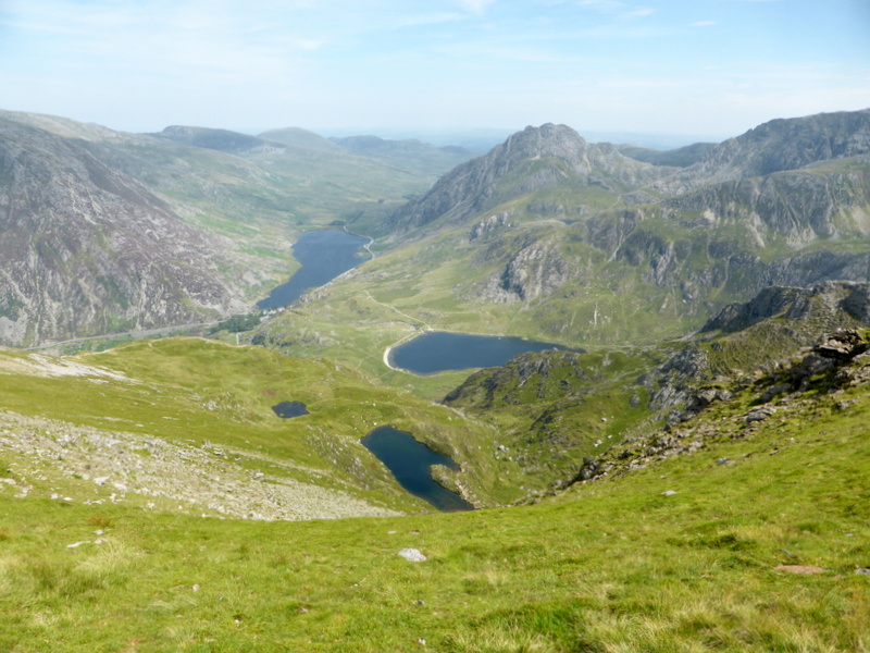
More large cairns mark the route down from Glyder Fach, though the Cambrian Way avoids the steep scramble down towards Tryfan, heading further east before dropping down a less eroded but steep path. This then doubles back towards Bwlch Tryfan and thence down to Idwal Cottage Youth Hostel. Most of this route is steep and tortuous, so progress is quite slow. Some parts of the path from Bwlch Tryfan to Idwal Cottage have already had repair work undertaken, with steps in steeper parts and stone paths in others, but there are still a lot that are badly in need of improvement. I eventually arrived at the hostel at 18.20 and was checked in by the very friendly, well informed and talkative warden. He was saying that locals prefer to take a ridge route up the left side of the valley from Nant Peris, as this avoids walking over all the rough ground and gives better views. I also found that the shop had a whole lot of ready meals, but the warden said that it had just been restocked and stocks can easily run out at busy times. He had a print out of tomorrow's weather forecast, which showed rain first thing, then better weather until thunderstorms arrived by about 4pm, so he advised setting off early.
When I was trying to book a bed here, the only things that showed as available were individual cabins at �39 rather than a dormitory bed which is about �20. It was very nice to have my own private room with its own washbasin, but I still think the price is a bit steep for a room that was only about two metres square and has no breakfast included. The problem was that if I didn't take the room, I would have to divert about 5 miles in one direction or the other to find anywhere else, so I just had to put up with the price. I didn't intend to do any washing, but I put anything that was damp or sweaty in the drying room so that it was better for transporting home. My boots were getting into an even sorrier state, but I was just hoping that they could survive for the twenty plus miles to Conwy.
The hostel has a very well equipped self catering kitchen and there was a shelf with some 'free to use' items with which I could supplement the things I had brought with me. It didn't take long to heat up my pasta dish, which was reasonably filling and I then had a few of my snacks to finish with. I had brought my own tea and coffee, but there was a free supply anyway, and I was able to buy a couple of bottles of beer from the shop.
Day 6 - Wednesday 19th July - Ogwen to Rowen via the Carneddau and Tal y Fan
GPS 15.4 miles, 5630 ft ascent
Accommodation: YHA Rowan
Sure enough, it was raining when I woke up, so I thought I would set off once it passed over and hope that I could get as far as possible before the bad weather started later in the day. I had brought a packet of Bachelor's Super Rice to cook for breakfast and there were free cereals on the shelf plus free milk in the fridge, so I could get a reasonable meal. The rice packet said 'Now cooks even faster - ready in 10 minutes' so I followed the instructions exactly, bringing the water to the boil then adding the contents of the packet and leaving it to simmer. The instructions said that it would be ready when all the water had been absorbed, but 10 minutes later the rice was still as hard as bullets and hardly any water had been absorbed. I then started boiling it vigorously and kept on stirring it until, after another 10 minutes, the water was all absorbed and the rice was cooked. To my knowledge, 20 minutes is the normal cooking time for rice, so there was absolutely nothing fast about this rice. I wondered whether the altitude of about 1,000ft above sea level might significantly alter the boiling point of water, but when I got home and checked on the internet, this would have only reduced the boiling point by about 1 degree Celsius, which I very much doubt would double the cooking time.
By the time I had eaten my breakfast and got myself ready to go, it was 8.45 and the rain had just stopped, so I set off across the road to where the path starts. The guidebook route avoids the very steep direct climb up Pen yr Ole Wen and to ensure that walkers did not disobey his commands, Tony Drake placed a checkpoint at the far end of Llyn Ogwen to ensure that the gentler ascent along a ridge is used instead. Of course, walkers can ignore checkpoints if they wish, but the idea was that anyone who does so cannot be deemed to have completed the walk.
A Dismal Start from Idwal Cottage
River Ogwen from Road Bridge
Path through Boulders at Start
The path by the lake is rather difficult at first as it skirts around a lot of rocks and boulders, but it gets easier as it progresses. The recent rain made it rather boggy in places, but no more that I had found in lots of other parts. I had given up on any idea of keeping my feet dry and just accepted that they would get either damp or wet depending on conditions underfoot. At the end of the lake, the ascent up the hillside started and it was quite easy to follow, with marker posts on the way up, and not too steep a climb. The cloud level was at about 2,000 ft, so visibility wasn't too bad, though the higher mountains were all obscured. After a steady climb, the path levelled off somewhat before the start of a steep scramble up the ridge to Pen yr Ole Wen. Though quite steep in places, it is not too difficult with plenty of hand and footholds on the steeper parts. As I climbed upwards, the cloud level was also lifting, so I still had some reasonable views most of the way until near the summit, where I entered the cloud.
It is not difficult to follow the route in mist so, after a short rest at the summit, I continued towards Carnedd Dafydd, the next 3,000 footer. Although I was in mist most of the time, it occasionally cleared a bit to give me some views down Cwm Lloer to Ffynnon Lloer, the lake below, albeit rather drab ones. By the time I reached the summit, the cloud had lifted further, bringing Carnedd Llewelyn, the highest mountain of the day, into view as well as considerably better views of everything around. As it was nearly 1 pm, I stopped for a lunch break half way between Carnedd Dafydd and Carnedd Llewelyn at one of my favourite points along this ridge, with a long view down the valley to the northwest where Afon Llafar meanders its way down the long valley deep below.
Ffynnon Llugwy Reservoir and Y Braich
Ascent of Carnedd Llewelyn
I took the opportunity to ring my wife, as I had good reception and, as we were speaking I suddenly stopped in my conversation, as there were rumblings of thunder echoing around the mountains. I had seen lots of dark clouds developing to the south and east, but it was still reasonably bright where I was, so I hoped the bad weather would pass by without affecting me. However, I thought it would be best not to linger and to make as much progress as I could. I met three other walkers who were out bagging a number of 3,000 ft peaks and they were heading, like me, towards Carnedd Llewelyn. Just as I was starting the steep ascent towards the summit, I felt raindrops, so decided that it was time to but on my waterproofs to prepare for the worst, and the other walkers decided to do the same. They went ahead of me to the summit and then over to the west towards Yr Elen, which was the next of the peaks they were going to climb.
The clouds got darker and darker and the rain started coming down in huge drops, whilst the thunder kept rumbling and echoing around. Most of the time there were no visible lightning flashes, but then the storm came closer, with flashes of lightning followed by thunder a couple of seconds later indicating that it was about half a mile away at its nearest. Being near the summit of the highest mountain in the Carneddau is not the best place to be in a thunderstorm, but there was not a lot I could do other than press on. Fortunately, there was little wind, so the rain was falling vertically rather than driving into my rucksack and though my waterproofs, but it was very heavy at times as it came over in waves. I met another lone walker who had come up from Llanfairfechan with the idea of bagging 3,000 ft mountains and, rather than heading back, he was thinking of continuing south towards Carnedd Dafydd. There is a mountain shelter on Foel Grach that he had stopped in for a while and that was where I was thinking of stopping too, arriving there at around 3pm.
At least I could have more of a rest than I had managed previously before venturing again into the mist and rain. Not long after I set off, I met the lone walker again. He had come to the conclusion that it would be more sensible to head back rather than venturing into unknown territory in mist and rain. He headed off at a quicker pace and I just continued trudging onwards, starting to feel a bit weary. Route finding was not really a problem, and I had my GPS to follow if I was in any doubt, but after a while the rain eased off and the cloud lifted so there was then quite reasonable visibility for a while. I made my way beyond the next two 3,000 footers of Carnedd Gwenllian and Foel-fras towards Drum, which is about 500ft lower. After a couple of small ups and downs, the route descended more steeply towards Bwlch y Ddeufaen, the pass where the main National Grid overhead power lines cross the mountains on the way from Wylfa Nuclear Power Station on Anglesey to feed the towns of North Wales. The power station was decommissioned in 2015, but there are plans to build another one. There is also a car park close by and this is the first place since Llyn Ogwen where there is easy access to the route. However, my destination was Rowen Youth Hostel, which was nearly three miles further along. This involved a steep climb of about 600 ft up to Foel Lwyd, then a lot of rocky walking towards Tal y Fan, which was the final mountain at just 2,000 ft high.
Inside Shelter on Foel Grach
Afon Anafon Valley to Aber Falls
By this time the weather closed in again as the cloud descended, though there was not much rain, just poor visibility, waterlogged ground and wet, slippery rocks making progress rather slow, especially after the draining effect of the bad weather conditions earlier. After Tal y Fan, the route follows the ridge for about half a mile to where the hostel route parts company with the main route and descends down the hillside for about 1,000 ft towards the hostel. The final little challenge is that, once down to the same level as the hostel, there is no right of way across and it is necessary to drop about 100 ft further down to reach a gate onto the very steep road back up to the hostel. I staggered in there at about 8pm looking like a drowned rat and feeling exhausted. However, I was heartily glad that I had decided not to walk the whole way to Conwy, which I have sometimes done in the past. This is difficult enough in good weather, but would have been that much worse today.
Rowen Youth Hostel is a small, self catering hostel mainly run by volunteer wardens, who generally spend a week at a time there to deal with checking people in and out, cleaning, changing bedding etc. in exchange for free accommodation for themselves. This is one of the ways that these small hostels have avoided closure, as they are not economically viable otherwise, which has led so many of them being closed in the past. The great thing about these places is that they generally have a much more friendly atmosphere, with hostellers and wardens enjoying the communal experience that has been lost from many larger hostels.
When the warden and some other hostellers saw me come in, they rallied round, offering at first a cup of tea, which changed to an offer of a beer. My boots were taken away to the drying room and some of the checking in formalities such as proof of identity dispensed with. I asked what time the pub down in the village stopped serving meals, but nobody knew and, as it meant descending another 400 ft with subsequent climb back up again, they suggested eating in the hostel taking advantage of the various free food that was available plus things that others were very generously offering me. Someone had put together a salad, there was a packet of pasta and a jar of pesto to go with it from the free food, plus chocolate biscuits and other snacks given by other hostellers. One couple who were staying had a little boy of about 5 years old and he offered me a Barney Bear, describing to me what it had inside. He went through all sorts of sweet ingredients and then said the middle was filled with stew! After that I said he had really sold it to me and I would have to accept the offer.
The warden said later that they were all feeling rather bad about staying in the hostel to avoid the bad weather and when they saw me, who had crossed the Carneddau, they got a touch of guilt, which is why I got such a good reception. She and her husband were saying that they had done a similar stint in Pwll Deri hostel on the Pembrokeshire Coast Path. It is in the most spectacular location high up on the hillside overlooking the bay. I have not stayed there, but passed it when I was walking the Pembrokeshire Coast Path in 2001 and also earlier this year on a holiday in Pembrokeshire. Apparently, though, there is now a serious shortage of volunteer wardens, which is threatening the existence of these small hostels. The turning point came when the YHA changed their system with bedding. Previously, it was up to hostellers to put on the sheet, duvet cover and pillowcase themselves, whereas now all the beds have to be made up by the wardens. In hostels where there are a lot of one night stays, such as those near long distance trails, this involves quite a lot of work which, in addition to the other things that the wardens have to do, makes the whole thing less appealing.
There were already three or four people in bed sleeping when I went up to my dormitory, which was quite surprising as it was not very late. It appears that they were workmen who were working on some water treatment plant nearby and they started work very early in the mornings. I tried to avoid disturbing them by not switching on the light and trying to be as quiet as possible, though they had various phones and a laptop that kept pinging whenever messages arrived and this didn't seem to bother them. Sure enough, at 6am various alarms went off and they got themselves ready for work, leaving me in peace. I then noticed that this dormitory had been recently refurbished so that each bunk had its own little bedside light with a socket next to it for charging phones etc. In addition, the room had a set of lockers for storing personal belongings. This is what I have always felt that most hostels lacked, even many of the larger ones.
Day 7 - Thursday 20th July 2017 - Rowen to Finish at Conwy via Conwy Mountain, then Home
Distance: GPS 8.3 miles, 1770 ft ascent
Accommodation: Home
Today would only be a half day walk with about 7 miles of walking, so there was no great rush. However, my daughter was going to pick me up from the finish at Conwy Castle and I had suggested that I might get there by about midday, but I would let her know a more definite time once I had a better estimate. I got up at my usual time and went down to breakfast at about 8am. Looking at the free food that remained, I could have some cereals and a repeat of last night's pasta with pesto sauce plus a cereal bar, so I set about making that and was able to get enough nourishment for my walk. There was no need to worry about lunch, as I would be in Conwy by then and I still had a few snack items left anyway.
After a chat with the wardens, I was off by 9.15, retracing my steps of yesterday. This time the weather was clear, though dull, but pleasant enough for walking with fine views across the Conwy Valley. My left boot was now in a dreadful state, as the Gore-Tex lining was well and truly worn though giving free access for water to flow in, but also to flow back out again, so apart from my foot feeling colder, it didn't affect me very much. Now that I could see where I was going, it was easier to make out the best route, as my GPX file was based on aerial photographs in which the paths were not very visible. The first mile was just getting back to join the main route, but this was made easier by not having to go back to the point where I turned off last night, but cutting off the corner and joining the route about 400 ft lower down. My energy had now returned, so I wasn't finding it as difficult climbing uphill as it had been for the past few days and I made good progress without having to rest very much.
Once I was back on the main route, it was much easier walking with a steady descent along easy tracks and views across the valley to Conwy Castle for much of the way. Further along, the route crosses to the western side of the ridge, so the views of Conwy are replaced by views of the hills near the coast: Penmaen Mawr and Foel L�s. The path that cuts across passes a small tarn, Llyn y Wrach (Witch's Lake), which is often dried up, as was the case now despite all the recent rainfall. Further on, Allt Wen beyond Sychnant Pass comes into sight. Here, it is easy to latch onto the main North Wales Path, but careful study of the guidebook shows that the Cambrian Way route does not take this but instead goes down a narrow lane close to the wall, then veers right where it emerges onto a narrow path running along the steep hillside. It is only recently that I realised this and have always taken the more obvious North Wales Path route on my previous walks of the Cambrian Way. On day walks in this area, however, I have often taken the narrow path, considering that the views from there are far superior, as it has a fine view down the steep valley to Capelulo and Dwygyfylchi on the coast and across to the eastern tip of Anglesey with its lighthouse at Penmon Point and Puffin Island not far away. This route is also slightly shorter as it is more direct. After passing Echo Rock, which is a good viewpoint, it descends to cross the old road from London to Holyhead, built by Thomas Telford, at Sychnant Pass. In modern times, the road route was modified to follow the coast by blasting out the Penmaen-bach Tunnels, thus avoiding the original hilly and winding route, but the old route is widely used as a scenic route for tourists and walkers. There is a car park there, which provides a good pick-up point, though it is now less than three miles to the finish.
Maen Penddu Standing Stone and Quarry
Towards Conwy Mountain
Site of Iron Age Fort on Conwy Mountain
Coast and Great Orme from Conwy Mountain
Conwy Castle from Conwy Mountain
Conwy Castle
Left Boot at End of Walk
I rang my daughter again to tell her it would be more like 12.30 before I reached Conwy Castle, so that she didn't have to pay for parking whilst waiting for me, it being better for me to arrive first so that she could just pick me up from the castle car park. To conclude the route in style, there was one more peak to climb; Conwy Mountain. As mountains go this hardly qualifies, as it is only 810 ft high, but in every other aspect it is a fine mountain, giving excellent views of the coast and the Great Orme as well as overlooking Conwy itself, the Conwy Estuary and the castle. There are also the remains of an old hill fort on top with information boards. To add to it all, the purple heather was just starting to bloom, mixed with the yellow of the gorse to give a very colourful end to the walk, even though it was still somewhat overcast. Dropping down from Conwy Mountain, the town and castle were in full view until the route joined roads in a residential area on the way into town. I was just walking along the road to the castle when my daughter rang to see how I was doing. She had just finished some supermarket shopping so came to collect me a few minutes later along with my one month old granddaughter and we returned home, then went out to the local pub for a meal.
After Thoughts
Looking at the unsettled weather pattern that had been predominant through the year I was not anticipating good weather for the walk, and I certainly had a fair mixture of weather conditions, from beautifully clear sunny weather to oppressively hot and humid conditions and from torrential rain and thunderstorms to low cloud, mist and drizzle. There was generally not too much wind, though any wind at all was appreciated in the hot weather when there was often not enough, whilst some of the heaviest rain was not accompanied by much wind, which helped avoid me and my belongings getting too wet.
One thing that struck me about this walk is that I have always done this section of the Cambrian Way after two weeks of walking from Cardiff, which had given me chance to build up my fitness and stamina and get used to carrying the weight of my pack. This time, I launched straight into tackling continuous, rugged high mountain walking from the start. I generally reckon that it takes me about four days to really get into a walk and overcome some of the fatigue that comes early on. If the early days of a walk are not too strenuous, then this works out a lot better as it gives the body chance to get used to the constant demands for energy. For this reason, most of my long distance walking has been on walks of two weeks or more as, on a one week walk, over half of the time is spent building up stamina, by which time the walk is nearly finished and that feeling of being comfortable and settled into the walk is over almost as soon as it has begun. One of the reasons given by Tony Drake for walking south to north rather than north to south, is that the mountains are not as high or as steep at the start, so it possible to build up stamina before the more difficult challenges come. Consequently, I found that there were times when I was finding it quite hard going and did not progress as quickly as I had hoped. However, the Cambrian Way is one of those walks where it is always worth allowing more time than might be expected for each stage, as it seldom works out any other way.
In addition to factors such as mileage and ascent, bad weather can slow things down as there is more chance of slipping or falling, which tends to make walking slower, especially when going downhill. On the other hand, there is less incentive to stop for long breaks in the cold and rain, so this can work the other way and speed things up at the expense of extra tiredness by the end of the day. The other thing that slowed me down was the attempt to survey the route whilst walking it, so I was trying to take more note of where I was going and what there was to see as well as taking hundreds of photographs of the parts of the walk that were on the main Cambrian Way route, weather permitting.
When I came to download the track logs from my GPS and my camera, I found the GPS had overwritten most of the first two days, as expected when it ran short of memory, but my backup was in the log from my camera. I had been careful to switch the camera GPS on at the start of each day and switch it off again at the end of the day to save on battery charge, so I expected a good set of logs. However, I couldn't find any trace of logs on the camera anywhere. After a bit of checking around, I realised that in order to get track logs, it is not sufficient just to switch on the GPS but also to switch on logging, which I had not remembered to do. I did use this function for a short while before I got my latest GPS, but had never used it since, so I had forgotten what had to be done.
Not to worry, all my photos would be geo-tagged, and I had taken the trouble to download the latest 'GPS Predict' file which shows what satellites will be visible at what times of day for the month ahead, thus speeding up the generation of the geo-tag. However, when I downloaded all my photos, most of them lacked a valid geo-tag and just had an effectively blank set of GPS coordinates. Perhaps 10% of photos had a valid tag and there seemed no logical reason why they didn't all have them, unless it was because I took the photo before the GPS was ready or because I switched off the camera before the tag had been written. I still do not know the cause, but I would have thought that in either case there should have been some sort of warning or delay to allow a tag to be recorded properly. It is not exactly clear from the user manual what the cause is either, but it is probably necessary to wait for the GPS icons to indicate that it is ready before taking the photograph. By taking a quick photo on the move, it probably has not had the time to decide where it is even though it is supposed to be tracking all the time that GPS is switched on, even when the camera is turned off. I will have to investigate this further in more controlled conditions before relying on this function again. Another possibility is that the GPS is not as sensitive as my latest Garmin, so may lose the satellite signals whilst I am carrying my camera on the belt round my waist where my body blocks some of the signals. I used to get this problem with my earlier Garmin and found that the only way I could get reliable logs was to carry it in the top pocket of my rucksack. Even having it in my hand could result in loss of signals. This would mean that it would take time for the camera to locate the satelites again as I was preparing to take a photograph.
The net result is that I have a lot of photographs that are not accurately pinpointed, but this can be aided by matching the time stamps on the photographs with the log from my GPS where it is not so obvious. Of course, this precludes the first couple of days of the walk for which I have no GPS log at all, and for the rest it will take a lot more time and effort. So much for technology. It is great when it works properly, but it can also be a big let-down when it doesn't.
Photography and Technology
Over the years that I have been doing long distance walks, camera technology, Internet technology and display technology have developed by giant leaps from 35mm colour slides that had to be scanned to produce low quality digital images for the website up to the present day with high quality digital photography, almost unlimited memory and super fast broadband,
The article in the 'Other Items' section chronacles all of this throughout my walks.