Price comparison - multiply by 1.74 for 2023 equivalent
The Cambrian Way is a mountain walk from Cardiff on the South Coast of Wales to Conwy on the North Coast. It was originally put forward by the Cambrian Way Committee in 1971 but, after a number of objections from various bodies concerned with footpath erosion and mountain safety, the scheme was abandoned in 1982. There has, however, been renewed interest in making it into a National Trail with pressure from The Ramblers' Association following the televised walk of the route by Janet Street-Porter. The Ramblers' Association have supported the idea from the outset, but the added publicity of the television series may help to sway the opposition.
The first guide book to be published in 1984 was 'A Cambrian Way' by Richard Sale, but this book is less of a practical guide book than a book filled with interesting facts and historical information about places on the way. Some time later, Tony Drake produced a much more pocketable and practical guide book with a route that differs somewhat in places, to take advantage of certain land acquisitions and permissive paths that came along after Richard Sale's book was published. 'Cambrian Way', subtitled 'A Mountain Connoisseur's Walk', by A.J. Drake has now reached its 5th Edition (ISBN 0 9509580 4 2) and is highly recommended to anyone planning the walk as it contains a lot of useful information with regard to the distances, ascents and relative difficulty of the terrain, as well as a list of accommodation along the way.
Note 2023: The Tony Drake guidebook was superceded by 'Walking the Cambrian Way' published by Cicerone in 2017. Some route changes and more accurate calculations show it to be approximately 298 miles (479km) with 74,000 feet (22,500 metres) of ascent on the main route.
Compared to most other recognised walks in Britain, the Cambrian Way is much more challenging in that its route runs over most of the highest mountains in Wales. It is 275 miles in length and involves an ascent of 61,540 ft (18,742 metres) with a considerable amount of difficult terrain, so should not be undertaken by the faint-hearted. When taking account of the extra distance walked for accommodation stops, getting lost (which is all too easy), additional sightseeing etc. the total distance is unlikely to be less than 300 miles. The mileage calculated is purely that taken from map measurements and this does not take account of the difficulty of some of the terrain. Wainright's guide to the Pennine Way adds an extra twenty miles to the map distance to take account of difficult sections, and these are nothing compared with the difficulties of the Cambrian Way. However, I still prefer to work on map mileage, making my own allowances for the terrain, as any other measurement tends to be rather subjective.
Planning and Preparation
Having done the walk twice before, I had a fair idea as to what sort of schedule I could achieve and which parts of the walk had proved the most difficult and may benefit from some changes to the schedule. There would inevitably be a few changes imposed by availability of hostels and B&Bs, some of which would have either closed or would be fully booked.
The most difficult section of the walk for accommodation is the stretch over the Rhinog Mountains, which is slow and hard going over difficult terrain, so needs to be split into two days for all but the very fittest. On my first walk in 2000, there was a small farmhouse offering B&B in Cwm Nantcol, a bit less than two miles off-route and I was able to stay there. By the time of my next walk in 2005, this farmhouse had stopped offering accommodation, so I had to go four miles off-route to another farm that had recently stopped doing B&B but who let me use their static caravan for the night. Even then I had to walk a further two miles to Llanbedr for an evening meal and back again.
Now, the only suggested option in the latest guidebook is to make use of taxis. It has been possible in the past to use the payphone in Cwm Nantcol to call a taxi to accommodation in either Llanbedr or one of the other towns or villages nearby, mobile phone coverage being very poor. However, the current situation with rural phone boxes is not good with many of them either removed, out of order or not taking cash, so this is not a very reliable option. Now the guidebook suggestion is to stay in Barmouth for two nights and take a taxi on the first day to Cwm Nantcol, walking this section in reverse back to Barmouth. The next day requires another taxi to Cwm Nantcol to continue the rest of the way. To me, this goes a little bit against the ethos of a long distance walk, which I try to do on foot as much as is possible, though I do make the odd exception now and again, generally in the form of a lift to a pub for an evening meal if it is a long distance away. The taxi option also involves quite a considerable extra expense, especially for a lone walker like myself with no one to share the cost.
A few years ago I noticed a place called Cae Gwyn beside the A470 near Bronaber, about 4 miles off-route to the east. They have a self-catering camping barn and also do B&B accommodation and there is a pub about a mile and a half away for an evening meal. This is not an ideal solution, but I decided to give it a try.
Another problem area for accommodation is in the Brecon Beacons. For the third time I was unable to get a bed in the most convenient place, Llwyn y Celyn Youth Hostel, which is very busy with school parties at this time of year, so had to take the Ystradfellte alternative again. The youth hostel there closed before my last visit in 2005 and the pub has only very limited opening times and no food. However, there are a couple of B&Bs who offer evening meals as well, so I was able to book one of those.
Another significant change to my schedule was from Dinas Mawddwy onwards. In 2000, my schedule was:
King's Youth Hostel at Penmaenpool having walked over a range of mountains including Cadair Idris
Cwm Nantcol, as mentioned previously, after the first half of the Rhinogs.
Maentwrog after the second half of the Rhinogau.
Nant Gwynant after Moelwyn Mawr and Cnicht.
Pen y Pass Youth Hostel after Snowdon.
Idwal Cottage Youth Hostel after the Glyderau.
Then the final leg to the finish at Conwy after the Carneddau.
The section from King's hostel to Cwm Nantcol proved long and tiring, yet the sections over Snowdon and the Glyders seemed too easy and short.
In 2005, I decided to have an easy day after staying at King's hostel by booking B&B at Barmouth, thus making the first part of the Rhinogs shorter, especially as I had to go further off-route for accommodation there. I also decided to do Snowdon and the Glyders in one day, which proved rather taxing, but I then split the final day with a break at Rowen Youth Hostel. This added an extra night to my schedule, with only half a day's walk on the final day.
This year King's hostel was full, so I made my schedule:
B&B in Dol-ffanog prior to the ascent of Cadair Idris.
B&B in Barmouth after Cadair Idris.
Cae Gwyn B&B half way along the Rhinogau.
Llys Ednowain, a new, independent hostel at Trawsfynydd instead of Maentwrog.
Bryn Gwynant Youth Hostel after Moelwyn Mawr and Cnicht.
Pen y Pass Youth Hostel after Snowdon.
Idwal Cottage Youth Hostel after the Glyderau.
Then the final leg to the finish at Conwy after the Carneddau.
The whole walk was scheduled to take 21 days plus a short walk from the start to Cardiff Youth Hostel on my day of arrival by train; a similar time to my previous walks but split up a little differently.
Training
Last year I had done hardly any walking prior to my long distance walk because I was heavily involved with work on my daughter's house and on the hotel. This was not ideal and meant that it took several days of the walk getting myself back into shape, suffering aching legs in the process. Although work on my daughter's house was still ongoing this year, we managed to get part of it finished sufficiently for her and her partner to move in at Christmas, and I was able to start taking more time out for walks, doing several reasonably long hill and mountain walks as well as my daily two to three mile walks with the dogs. This made me feel a lot happier about setting on a walk like the Cambrian Way, which would have been much more difficult to undertake without training.
There was also another factor to consider, which was my age. This will undoubtedly take its toll at some stage, though it has not done so yet. At 65, I cannot always muster the bursts of energy that I might have done ten or twenty years ago, but I can still manage to do similar daily schedules by taking one or two more rests here and there without adding too much extra to the time required. It still encourages me when I see people in their seventies and eighties up in the mountains and I only hope that I can continue to be up there as well when I am that age, even if I do have to slow down a bit. It also encourages me to think that I can still take on far more than I could in my teens and early twenties, mainly because I lead a far more active life now, rather than the sedentary life I led when I was younger, with just occasional bouts of mountain climbing, but never enough to get properly fit.
Day 1 - Tuesday 1st June 2010 - Home to YHA Cardiff via Cardiff Bay and Castle
Distance: GPS 7.8 miles (only 2 miles on route) - very little ascent
The GPS mileage figure is what I recorded from accommodation to accommodation, and includes any small detours, meandering around, and errors in route finding. In general this is about 5% to 15% greater than the mileage calculated from a map, depending upon the type of terrain, but in some cases is considerably more.
Accommodation: YHA Cardiff
After several weeks of bright and sunny weather, the time had come for me to set off on my walk and I awoke to a damp, drizzly morning with low cloud everywhere. It didn't worry me too much, however, as it was a day mainly for travelling by train from North Wales to Cardiff. There was just a bit of walking to do along the route to Cardiff Youth Hostel, which is on the outskirts of the city. Normally, I also walk down to the redeveloped docklands area by Cardiff Bay and then back along the River Taff, almost to where I started from, before walking to the hostel. However, I could easily miss out the return trip to the bay if the weather were still bad.
Still, the weather did make a difference to the way I felt as I set off on the train. Bright, sunny weather brings about a surge of enthusiasm to get started, with the promise of beautiful scenery and enjoyable walking. The damp and dreary weather on the way, with the hills covered in low cloud, had the opposite effect with thoughts of trudging along in the rain and mist with no views, just trying to get finished and to get dry. After a while, the drizzle more or less stopped, but the blanket of low cloud stayed firmly in place all the way to Cardiff.
The journey was uneventful with the trains all running on time and there was not too long to wait between connections. There was not even the overcrowding that is commonplace for some parts of the journey, but then I was travelling on the Tuesday of the Spring Bank Holiday when all the schools and colleges were closed and many people would be on holiday, but not generally travelling. I arrived in Cardiff Station just before 15.00 and decided that, as the rain had virtually stopped, to do my usual walk down to Cardiff Bay.
It was interesting to see that there had been quite a lot of new development to add to already extensive dockland development I had seen before, with large blocks of apartments everywhere. I reached the bay via a wetland park, which was very pleasant with lots of wildfowl and wetland plants. From there I wandered along to Mermaid Quay and then to the Bute Dock building with the Welsh Assembly Government building next to it. Last time I was here, the Welsh Assembly building was still a building site with just the red-bricked offices at the rear fully built, but not the frontage built out of slate and wood. I had seen the completed building many times on television and had some reservations about its design, but seeing it for real did nothing to improve my feelings. The whole thing looked totally out of place and the extensive use of grey slate didn't blend in with anything else nearby, especially the beautiful Bute Dock building. It may have looked better in one of the slate areas of North Wales, where it would have been in harmony with the surroundings, but it just didn't fit into the architecture of Cardiff.
As for the large canopy that extends out over the steps to the front, which is the main feature of the building, it looked like some huge awning with spindly poles at the front for support, making it look out of proportion and again out of place. It would be more fitting over a bandstand in a park somewhere. The only thing I could see in its favour was that it cost considerably less than the Scottish Parliament building. But then these things are all a matter of taste and I am sure that some people must think it is wonderful. There is nothing I could see to say what the building is, presumably for security reasons, and I passed a couple of ladies who were discussing its use, thinking it was probably for open air concerts or something, which I found quite amusing.
Bute Dock & Welsh Assembly Government Building, Cardiff
Clock Tower, Cardiff Castle - Official Start of Cambrian Way
The whole area was very quiet compared to last time I came, when there was an eisteddfod on at the arts centre. With the weather still dreary, I made my way back beside the River Taff, past the Millennium Stadium and Brains Brewery, to Cardiff Castle, the official start of the walk, which I reached at 16.45 (checkpoint 1). Even the front of the castle had changed, with a new entrance and ticket office outside the castle gates so that it was no longer possible to reach the gates for a better view of the keep inside the walls without buying a ticket.
From the castle, I followed the route alongside the Taff through Cathay's Park, first past ornamental gardens and then along mature wooded riverbanks. The woodland thinned out further along towards the weir, where I turned off to find an exit from the park and make my way to the youth hostel. Because some of the park exits are not very obvious, there are various signs pointing in the direction of the nearest exit, but not saying where the exit leads to, so the nearest one is not necessarily the one that you want. There is a cycle track running along the eastern side of the park and I made my way along that until I found the exit I was looking for, which meant doubling back a little, but there was no other one I could see taking me nearer to where I wanted to be.
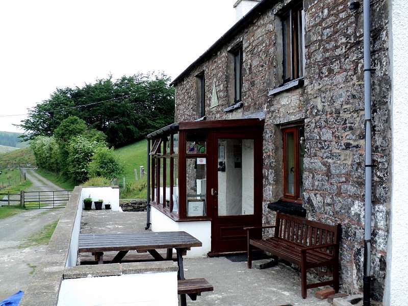
By now I was feeling a bit tired and my shoulders were aching from the weight of my pack, but then I had walked for nearly seven miles without a rest, so it was not surprising. There was no point in stopping now, so I carried on along the main road, across the railway bridge and down back streets past the huge cemetery to the youth hostel, which I reached at 17.55. This again had changed somewhat since last time I stayed when it was in the middle of a refurbishment. Despite being a city hostel, it is still quite small and quiet, probably because it is a couple of miles from the city centre. There were plans at one time to build a new flagship hostel in the Cardiff Bay area but this never materialised, presumably from lack of funds.
A very friendly and efficient young lady greeted me when I arrived and I was pleasantly surprised to find that the �16 I had paid for my bed online also included breakfast. My YHA membership had expired, so I renewed it for �15.95 when I checked in. It is debateable as to whether it is worth taking out membership these days. At one time it wasn't possible for non-members to stay at most hostels, but now non-members just have to pay an extra �3 on the price of a bed. This means that you have to stay at more than five hostels in one year to make it worthwhile joining. I had managed to book six hostels on this walk, so it was just worthwhile renewing my membership. Also, the membership runs to the end of the month in which you join and this was 1st June, so I effectively got 13 months membership for the price of 12. The hostel doesn't serve evening meals, but I had already decided to go out to The Heath at the opposite corner of the cemetery. The hostel refurbishment had incorporated an en-suite wet room with disabled facilities in the dormitory that I was allocated, which was quite handy, and there were only a couple of other chaps in there with me, so it was quite peaceful.
After a rest, I set off to The Heath with the weather showing distinct signs of improvement. There were a few patches of sunshine to brighten up the evening and to give me more hope for tomorrow's walk. At The Heath they were only serving a limited menu of bar meals, but that was fine for me and I had some very good chilli nachos with a portion of chips for less than �5 along with a couple of pints of Brains SA at �2.65 a pint. It is very good for consumers these days with pubs offering cheap deals on food and drink, but looking at it from the other side of the fence it is a different story. Many of these deals return very little profit except, perhaps, for the large chains that have bulk purchasing power and large volume turnover giving efficiency of scale. Other pubs have to try to match these if they want to retain customers, even if they make little or nothing on them. Also, breweries keep on pushing up prices to the licensed trade, particularly of beers, at more than the rate of inflation, whilst at the same time, discounting more and more heavily to the supermarkets. Pubs cannot pass on these price rises in a recession for fear of losing what little trade they have, so end up having to reduce profits. The upshot of this is that many of our traditional pubs will close forever and all that will remain will be the big chains. The Heath, like many pubs these days, was very quiet, with just a handful of locals at the bar � barely enough to pay the staff wages, never mind all the other overheads.
I returned to the hostel and to bed.
Day 2 - Wednesday 2nd June 2010 - YHA Cardiff Youth to Crosskeys via Rhymney Valley Ridgeway and Mynydd Machen
Distance: GPS 19.5 miles including 1.5 miles in error - 2,022 ft ascent
Accommodation: B&B Crosskeys
I was up at 7.30 ready for breakfast at eight o'clock with a good selection of both hot and cold things, all very nicely done and with no limit and the things you could have, which put it on a par with most B&Bs. Considering that the breakfast was included in the price, this hostel was very good value for money and far better than others I had booked in Snowdonia at �18 for bed only.
Being the first full day of the walk, it took me a little longer than usual to sort out everything I needed for the day, so it was 9.20 before I left the hostel and 9.45 before I rejoined the route by the weir on the River Taff. My GPS measured nearly 1.4 miles to get back on the route, which is further than it looks on the map, but that is because of the rather indirect route to get into the park.
I always marvel at the tranquillity in the park. Rooftops and buildings can be seen through the trees not far away, but there is hardly any traffic noise except where main roads actually cut across the park and river. There were squirrels about and the constant sound of birdsong with the only clue that this was near an urban area given by the number of joggers, cyclists and dog walkers. The route was still flat and easy, following the Taff Trail, which was well signposted along the river. A bit further along there are more open spaces and playing fields but still trees lining the riverbank. A small detour out of the park is required to go through a bridge under the railway and then by some suburban housing. There should be a restored water wheel by the roadside, and I was a little taken aback when it was no longer there, but then I saw a sign saying that it had been taken away for further restoration.
Weir on River Taff, Cardiff
Glamorgan Canal Nature Reserve, near Tongwynlais
I was happily walking along following the Taff Trail in the pleasant morning sunshine and forgot to look out for the turning by the old canal, which is now a nature reserve. The next thing I knew I was at Forest Farm, about half a mile past the turning. I could have carried on that way and rejoined the route a bit further on, but I was trying to follow the guidebook as closely as possible, so retraced my steps back to where I had gone wrong. The canal is disused and covered in water lilies, some of which were just coming into flower with the benefit of some sunshine, but others that were in the shade were not yet in flower. There were quite a number of ducks and other wildfowl as well as squirrels and birds, with much flora including irises. Of course, it wouldn't have been quite complete without the odd supermarket trolley and a few bottles and cans!
The canal and nature reserve come to an abrupt end at a steep embankment leading up to a large intersection on the M4 motorway, but despite the close proximity of busy traffic, it was still very peaceful by the canal, so I had a rest there at 11.30. I was finding the walking quite easy, despite not being fully accustomed to the weight of my pack - it was far better that I was now walking in my boots, which have more cushioning and support than the trainers I was wearing yesterday afternoon. The sunshine was making it quite warm at times, but it was cool in the shaded areas of the nature reserve.
I was off again at 11.50, climbing the steps up to the motorway intersection - hardly mountain climbing, but the first climb on the way so far. There are a number of footpaths going over and under various parts of the intersection, which could be quite confusing, but the guidebook has a good sketch map of which ones to take to get out onto the road to Tongwynlais, with Castell Coch up above on the hillside. A steady climb up the hill out of Tongwynlais took me towards the access road to the castle, a picturesque Victorian castle rather than a real defensive one. Just before the access road, I took a footpath that ran just below but, as the guidebook says, this didn't go quite high enough to reach the castle and I had to scramble up a steep bank to reach it. This was checkpoint 2, which I reached at 12.20. There were quite a number of people around, it being still part of the Spring Bank Holiday week, but I didn't stop to look around myself, other than to take a couple of photographs, making my way up the hill through the forest to continue on the route towards the Ridgeway. Unfortunately, there are no views through the forest, but it was still pleasant and fairly easy walking in the sunshine with just a steady ascent.
Tongwynlais with Castell Coch on hillside
Rhymney Valley Ridgeway near Thornhill
Rhymney Valley Ridgeway near Thornhill
When I came to the first road crossing, I mistook the tarmacked road to the car park for the road itself and consequently took a wrong turning until I realised I was going too far downhill and had to turn round again, wasting about a third of a mile and some extra ascent. Once out of the forest there were more views, but seldom very wide or far ranging ones, more like glimpses of the countryside through trees lining the path. Further on, just before Thornhill, the route goes through a golf course, but there were not many golfers playing despite the good weather, though they could have been having lunch. Even though views were limited, the walking was more interesting, with mature woodland and a greater variety of trees than in the previous forestry plantation.
It was time for a lunch break, but I wanted to wait until I got somewhere with a view which, from previous experience was by the old quarry near Cefn Onn. Having already wasted time with a couple of mistakes in navigation, it was a case of more haste less speed as I made another silly mistake and started dropping down rather than being up near the top of the ridge. There are a few ups and downs along the route, so I had gone a few hundred yards before I realised my mistake and had to retrace my steps back up the hill to where I should have forked right. Passing through a wood with a vast area of wild garlic, I at last came out into the open by the quarry and was able to take my lunch break somewhat later than planned at 14.00. There was some distant haze, but there was a good view across the valley of the hills to the north, with Caerphilly down below and its castle just in view. It was very peaceful and relaxing in the sunshine overlooking the steep drop down into the quarry. The only sounds breaking the silence were the birds and the distant sound of some machinery way down in the valley. I finished off half of the packed lunch I had left from yesterday and set off again at 14.45.
Old Quarry near Cefn Onn
Caerphilly from Old Quarry near Cefn Onn
A mile or so of open walking with wide open views brought me to more woodland, which was greatly improved by having bright sunshine streaming in through the trees. Even forestry plantations look better in these conditions unless they are so densely overcrowded that they exclude any light at all. It was a joy just to be out walking in such good weather conditions whatever the scenery. There was some more open walking at Rudry and then back into woodland to Machen.
It doesn't help that my GPS spends most of its time saying 'Weak GPS signal - need clear view of sky' whenever there are overhanging trees or other obstacles in the way including my own body. For the last few walks I have started to make more use of my GPS as I am walking along. At first I just used to get it out and switch it on whenever I got a bit lost. There is then some delay whilst it searches for satellites and this can be a bit of a nuisance, though it does mean there is much less battery usage. I then started to leave my GPS on all the time I am walking so that it can record the actual distance I have walked. This also means there is no waiting whenever it is needed for a grid reference or direction. The problem is, though, that if it is kept in a pocket, it spends half of the time without enough satellite signals to work properly, so I used to put it in the top compartment of my rucksack. This then meant that whenever I needed it I had to stop, take off my rucksack and get it out. This time, as the Cambrian Way takes more navigating than many walks, I decided to have my GPS available all the time as well as leaving my glasses on all the time. This meant that I could read maps and the GPS without constantly having to put them on and take them off. However, this then left the question of what to do with the GPS whilst I was walking along. It will work reasonably well in my shirt pocket but the bulk and weight soon makes it uncomfortable there, so the only option was to keep it in my hand the whole time. This could be a nuisance at times, but I could always slip it into my shirt pocket for short periods whenever necessary. When used like this, battery life is much reduced and requires rechargeable batteries to be charged up every day or alkaline batteries to be replaced every couple of days. With the GPS always to hand, I could check my route more easily without even having to stop walking, though judging by today's performance I didn't seem to be making best use of it.
Tony Drake, in his guidebook, strongly recommends the use of 1:25,000 OS maps for the walk. I bought a set of 1:50,000 maps about 15 years ago and have been reluctant to replace them with 1:25,000 maps, thinking that with the aid of my (rather poor) memory of previous walks and with help from my GPS, I could manage all right. However, in some parts, the lack of field boundaries on the 1:50,000 maps makes navigation more difficult and it is still easy to lose the way. In theory, the GPS can help, but in practice it tends to be mainly when I have already gone wrong that I make use of the GPS to get me back on the right track, whereas the 1:25,000 maps may have helped me not to go wrong in the first place. Regardless of maps and GPS, most of my errors of navigation come down to not paying enough attention to the route and continuing to follow a well-trodden path without keeping my eye out for where I should be going next. In many ways, it is not always an advantage to have done the walk before, as I have a tendency to think that I know where I am going and don't keep my eye on the map as much as I would do when walking it for the first time.
At Machen, I decided it was time for another short rest before tackling the main climb of the day up Mynydd Machen. There was nowhere very nice to stop by the main road, but I saw a handy bench by the door of St John the Baptist's Church at 16.15 to have a drink and a fifteen-minute break. There is a steep climb up Mynydd Machen at first, but this turns into a gentler one as the path goes at a diagonal up the wooded hillside. I went up at a good pace, as there had not been a great deal of climbing so far, so I still had quite a bit of energy left. The views were limited because of the trees, but these did at least give me some shade to keep me cool. At the end of the forest, there is no properly defined path to the summit, but the obvious way is to go straight up the steep slope, which meant taking a few short breathers on the way, reaching the summit at 17.05 (Checkpoint 3).
Though its name would suggest that it is a mountain, at 1,192ft Mynydd Machen falls far short of the 2,000ft to be strictly classified as such, but it does give some good views of the nearby valleys, once home to a large number of coal mines before they became uneconomic. Because of its flat top, though, it is necessary to walk a little round the edges to get the best views, which I did before continuing down the track towards Risca. On reaching the road, there is some confusion about the right of way, which the OS maps show as going past the nearby farm, whereas the guidebook shows it going across the field to the right of the farm, where there was a gate and a stile but no fingerpost or waymark. It looks as if the path has been diverted away from the farm but that this has not been updated on the OS maps. However, this was not a problem and I was able to find a wide stile looking more like a horse jump, where the path entered the forest. This has a tendency to get overgrown, and on this occasion that was the case, though it was still possible to make my way through the undergrowth and saplings without too much difficulty.
Crosskeys and Risca from Mynydd Machen
Where the path emerged onto a forest track, the OS map shows it crossing over and continuing down the steep hillside, but there was no sign of a path there and I had to turn right along the track, going uphill again for a little way before the track doubled back and went down again. There was then a clearly marked bridleway going the rest of the way down to meet the road into Risca. My B&B was in Crosskeys, about half a mile off to the west and I arrived there at 18.05.
After freshening up with a shower and phoning home, I set off out to find somewhere to eat. The landlord suggested the Cross Keys, a quarter of a mile away but I didn't see it on my way and ended up in the Darran Inn where I ate last time, and where I stayed the time before when the previous owners did B&B. I had a lovely pint of Reverend James, which went down very quickly at the end of a hot day's walking. I then noticed on the menu that Wednesday was curry night with curry and a drink for only �5.75 plus 50p for naan bread. I had to double check that it was Wednesday, as I was already starting to lose track of time even at this early stage of the walk. It was, in fact, Wednesday, so I was in luck, though the drink was only a pint of Brains Smooth, but it was still a bargain. I sat outside for a while but all the tables were on a slope and rather uncomfortable so I had the meal inside instead and finished off with another pint of Reverend James outside before going back to watch TV for a while. The big news story of the day was about the multiple shootings in Cumbria and the subsequent suicide of the gunman, something that tends to make a place stick in one's mind, a bit like the events of 9/11 when I was walking the Pembrokeshire Coast Path in 2001.
Day 3 - Thursday 3rd June 2010 - Crosskeys to Abergavenny via Twmbarlwm and Blorenge
Distance: GPS 21.6 miles - 3,200 ft ascent
Accommodation: Black Sheep Backpackers' Hostel, Great Western Hotel, Abergavenny
I had a good breakfast at eight o'clock and chatted for a while with the landlady about the state of business in the recession, so then had to rush around to get away by 9.05, as I had a long walk ahead and needed to get off to a reasonably early start. It was a lovely day but with some distant haze limiting the visibility to about ten miles. Walking towards Risca to rejoin the route, I forgot to look for the turning up to join the canal towpath, so turned up by The Darran Inn a little further along. There is a long steady climb up the road and then a track, but I kept on going as I still felt fresh and I had no problems with my feet or leg muscles so far. The shade from the trees kept me cooler, but I was still getting quite hot in the morning sunshine. Towards the summit of Twmbarlwm, an old hill fort, the path gets considerably steeper, so I had to have a few short breathers until the slope started to ease off and I was able to walk continuously again, reaching the summit at 10.05 (checkpoint 4).
Sculpture at Pegwn-y-bwlch on ascent of Twmbarlwm
Looking back down to Pegwn-y-bwlch on ascent of Twmbarlwm
Outer Fortified Ditch of Twmbarlwm
At the summit there was a nice cool breeze and I stopped for a drink and a 10-minute rest. The views were somewhat limited by the haze, but there was still quite a bit that could be seen. I was just pondering on the fact that nobody else was around on such a nice morning, other than a man in a van on a track below, when a couple arrived at the summit just as I had departed and then several others appeared as I walked along the ridge.
Summit of Twmbarlwm Hill Fort
Ponies on Mynydd Henllys
The walking was easy, along grassy tracks, though they were deeply rutted in places, partly by motorcycles being illegally ridden over the hills. The views over the low lying land below were nothing particularly special but it was nice open walking in fine weather, so that made me feel good to be there. After a while, the route drops down the hillside towards the small Blaen Blan Reservoirs. I always seem to take the wrong path down here, staying too far up the hillside and then having to double back down a steep path, because I have been taking a little bit too much notice of the comment on the sketch map in the guidebook saying 'keep to contour'. This is a case where the 1:25,000 OS map may have helped, as the footpaths around here look rather confused on my 1:50,000 map. The reservoirs were dry at the moment and I wasn't sure whether this was because of the long spell of dry weather or whether they had been drained for some reason, as they were not empty on my last visit. I notice that they are shown on the latest 1:25,000 map as disused and not coloured in blue, whereas the 1:50,000 maps shows them in blue and doesn't mention disused, so they may only recently have been taken out of service.
The path then follows the boundary wall of the common, which is not the best, as there are overhanging branches from the woodland on the other side of the wall making it necessary to walk, in parts, on the steeply sloping hillside, with no views to either side, and it made me wonder whether there might be a more attractive and easier route with better views by following the ridge further along before dropping down. On my first walk here I went over to the summit of Mynydd Twyn-glas, simply because I was keen to do as many summits as possible near to the route, but this rather flat topped summit was not particularly interesting. However, there are one or two other routes following the edge of the hillside near the top that may well offer a more interesting route.
I was feeling tired and in need of a rest, but decided to carry on to get a few more miles in before stopping for a lunch break at Pontypool. Eventually the route opened out more on the way to Mountain Ash, albeit on a more uneven track and then it runs alongside the minor road past the Lamb Inn before dropping down to Pontypool. The map in the guidebook shows a road running all the way down, whereas there is a section of road to start with, then a rough, sunken lane followed by another road at the bottom leading out by a roundabout near Pontypool Park. On the way to the park is an Esso filling station with a shop where I was able to buy some things for lunch, which I ate sitting on a bench just inside the park gates. It was 12.30 and I definitely needed a good rest, having walked about nine miles with only one short rest on Twmbarlwm.
At 13.10, I was off again, taking the steep and rather overgrown path up the hill beside the park. I was not feeling as fit now as I was first thing this morning, but I just kept up a steady plod and gradually the slope eased off and the views opened up as I headed towards the Watch Tower, a folly on the ridge. There was a backdrop of hills now to the south and west. This was good, open walking country now, though the paths were sometimes uneven and my heels were starting to get sore where my boots were starting to rub. This rang a few alarm bells, as the last thing I wanted at this stage of the walk was blistered heels, so I tried to walk more carefully, placing my feet down more evenly to avoid as much of the rubbing as I could.
Reaching Garn Wen at 14.20, I stopped for a ten-minute rest and a drink before continuing along a path by the eastern edge of the common. This was more fine walking country with good distant views and lots of interesting undulations on the common itself. There were paths and tracks running all over the place, as is often the case over commons, but the route near the edge also gave better views down into the valleys below. At one point there was a good view of Abergavenny, with Sugar Loaf on one side and Skirrid on the other. I only noticed later that the guidebook shows a more direct route, cutting of a bit off the corner, but it was too late to bother trying to make my way across rough moorland to rejoin the route and it was easier just to continue the way I was going.
Now moving away from the edge of the common, the views were more limited, with some distant views but with few features nearby. The miles always seem to take longer over this sort of country, as the scenery only changes very slowly. I eventually reached the minor road crossing and picked up the path towards Foxhunter's Grave, which is easy to find using the twin radio masts nearby as a guide. This is the country for stubbed toes, trips and twisted ankles if care is not taken, as there are lots of stones sticking up in the path and it needs eyes constantly on the ground to avoid them. However, there was not much of a view to look at anyway, just a lot of featureless moorland, so it didn't matter too much that all my attention was on the ground. Though the path meanders around somewhat, it is easy to follow, as there are marker posts for much of the way, with a fairly clearly defined path through the heather. After what seemed like a very long time, the radio masts gradually got closer and closer and I reached the roadside car park by Foxhunter's Grave at 16.20.
Foxhunter's Grave
Blorenge from Foxhunter's Grave
Summit of Blorenge with Sugar Loaf behind
I was quite surprised by how many people there were around the car park, though only a few seemed to be visiting the grave itself, which is only a short walk away. My shoulders were aching a bit by now, so I stopped for a rest and a drink near the grave, with about four miles left to go. At 16.45 I set off up the gently sloping path towards Blorenge. The summit itself, which I reached at 17.00 (checkpoint 5), is just a small mound of stones on a rather flat-topped plateau, but the real beauty lies at the edge of the steep northern face. Though I had been here twice before, the first time was in fairly poor weather and the second time in mist, so this was my first chance to see the views in brilliant weather conditions. The sun was shining brightly and the earlier haze had mostly cleared sufficiently to give a good view of the surrounding mountains. There were already some views of Sugar Loaf and the Black Mountains from the summit, but the vista from the edge was absolutely stunning, with a bird's eye view of Abergavenny below, the whole of the Black Mountains to the north-west and a full view of Sugar Loaf and Skirrid. It is views like this that make all the effort of walking and climbing worthwhile and I had to sit there for a while just taking it all in.
Abergavenny and Skirrid from Blorenge
Sugar Loaf from Blorenge
Tunnel under Monmouthshire & Brecon Canal near Abergavenny
River Usk at Abergavenny
After a while it was time it was time to move on, as I still had a few miles more to walk to reach my accommodation in the Black Sheep Backpackers' Hostel near Abergavenny railway station. On previous occasions, I have made my way along the edge of Blorenge southwards past the steep cliffs until I found a way down the steep hillside, but this time I investigated the route directly beneath and found a path, albeit very steep, going straight to where I needed to go. There were steps in the soil where people had climbed up and down the steepest part of the slope, so this made things easier, though it is always more difficult trying to maintain balance with a heavy pack. It was a bit of a strain at the end of a long day's walk, but it was not too long before I reached the bottom and started on another steep path down to the tunnel under the canal. After all the strain on my legs from the steep descent, it was a relief to get onto more level ground for the rest of the way into Abergavenny and then along the Brecon road to the Hotel by the station. The Great Western is a pub, which which also houses the hostel, and I arrived there at 18.30.
The first thing I needed was a pint of bitter and the next thing was a shower, after which I felt much better, though I was still rather weary. The shower was just across the corridor from my dormitory, which had a door with a key code lock to which I had been given the access key written on a card. I was careful to take the card with me to the shower so that I didn't get locked out. However, when I had had my shower and returned to the dormitory I realised that I had a problem. I hadn't bothered to take my glasses with me and with rather dim lighting in the corridor and eyes that were rather tired I could make out neither the numbers on the keypad nor the code that was written down on the card. There was a window at the end of the corridor giving more light, so by going over there and straining my eyes I just about managed to read the code from the card but when I returned to the door I was still struggling to make out the numbers on the keypad. After a lot of squinting and some guesswork and logical deduction plus a lot of trial and error, I managed to figure out the keypad layout but no matter how I tried I couldn't get the door to open. I kept making trips to and from the window to check that I had read the code correctly, but still had no success in opening the door. It was getting to the point when I was going to have to admit defeat and go back to the young lady in the bar for help when she just happened to come along the corridor. She quickly pointed out that what I thought was a 7 was actually a Y, the keypad having numbers from 0 to 9, C for Clear and X, Y and Z. At once, I was able to get back into the dormitory and get myself ready to go for something to eat.
Last time I stayed in this hostel was in 2005, when the only accommodation was a mixed-sex dormitory in the basement with a rather grubby shower that had seen better days. Now, however, the basement had been refurbished with some new showers and a lounge as well as the kitchen that was already there previously, but all the accommodation was now in rooms on the first floor of the hotel. Everything was of a considerably better standard, though some of the maintenance was a bit lacking, but no worse than many youth hostels. At �15 a night including a help-yourself light breakfast of cereals, toast etc., it represented good value for money, especially in an area where many B&Bs are quite expensive.
The Great Western Hotel didn't appear to be serving any food, so I went back into town for something to eat. There were several pubs and restaurants in town, but I decided to have some fish, chips and mushy peas from the chip shop. The fish and chips were already cooked, but I had to wait about five minutes for the mushy peas to be heated up in the microwave. However, when I came to eat the peas, they were only lukewarm and tasted quite revolting. The fish and chips were also not particularly good, so I would probably have been far better off getting a bar meal somewhere.
After wandering around town for a little while, I called in at the Hen and Chickens for a couple of pints of Reverend James before heading back to the hostel for an early night. When I got back, my only roommate, whose large rucksack and walking boots were in the room before I went out, was already in bed trying to sleep, so I went to bed myself to do the same.
Day 4 - Friday 4th June 2010 - Abergavenny to Capel-y-ffin via Sugar Loaf and Chwarel y Fan
Distance: GPS 15.6 miles - 3,443 ft ascent
Accommodation: Grange Trekking Centre, Capel-y-Ffin
My roommate left early at about 6.45, so I never get chance to speak to him or to find out where he was walking. I got up myself at 7.30 and went down for breakfast at eight o'clock. The general idea is that the kitchen is stocked with cereals, bread, margarine, jam, milk, tea, coffee etc and hostellers just help themselves to the food and the self-catering facilities. There was not a great deal of choice and some of the items were running very low, but there was just about enough of the things I needed to get by with corn flakes, toast and marmalade and tea. However, as a few others started to arrive, they were faced with dwindling supplies. Some who had been there for a few days complained about the lack of restocking, especially when they had notified the young lady in the bar that things were running out.
I had less distance to walk today, so got off to a leisurely start at 9.15, going through town, where I took a look at the castle and called into a Tesco Express at the northern end of the town centre to get a few things for lunch. A �2 meal deal bought me some sandwiches, a bottle of orange juice and a small bag of fruit and I also bought a malt loaf and some Welsh cakes that would keep well enough in the hot weather for tomorrow. It was 10.05 as I set off out of town, having downed the orange juice before I did so.
Abergavenny
Ruins of Abergavenny Castle
Approach to Sugar Loaf Summit
The weather was bright and sunny again with distant haze, giving good views of Sugar Loaf ahead and Blorenge behind, from various places along the way. There are several routes up Sugar Loaf, but the guidebook route goes via Llwyn-du, where I passed through a field of buttercups on the way to the ridge. I followed various signs to Sugar Loaf, but soon realised that instead of heading towards the top of the ridge, I was following a track along the western side through woodland halfway down the slope, leading towards a different ascent of Sugar Loaf. The trees blocked off any views, though they did shade me from the sun, which was already getting rather hot. Rather than turning round, I carried on and made way up to the top of the ridge at a convenient place further along. There was a steep climb up the hillside to contend with and I gained a few scratches from the hawthorn and gorse, but I was rewarded with a view of Sugar Loaf ahead.
A number of people were ahead of me, some with small children, and more were already at the summit, which I reached at 11.35 (checkpoint 6), after a steady climb most of the way with a steeper bit towards the end. There was a fresh breeze at the top and a good view of the Black Mountains, albeit a bit hazy. I was feeling quite refreshed today despite two rather long days, and I had been able to make quite good progress so far. There were a few minor problems with my feet in that one small toe was sore but not quite blistered and my heels were a little tender, but again had not yet got any blisters, so I was trying my best to keep them from getting any worse.
Sugar Loaf Summit
Black Mountains from Sugar Loaf
Towards Forest Coal Pit from Sugar Loaf
After a rest at the summit, I set off down towards Fforest Coal Pit at 12.10. I met up with a couple on the way down. They were reasonably local and came up here quite often to walk their dogs, but they were quite interested in my walk, so I chatted with them for some way before they turned off. At the bottom, the path can get very boggy, but with the lack of rainfall recently, it wasn't too bad today. Whereas there had been a cooling breeze at the top, it was more sheltered and much warmer down at the bottom, and when I started my ascent up the road from Fforest Coal Pit, I was getting very hot, so just took it steadily. However, further up I caught some breeze again and on top of the ridge it was very pleasant.
This was a good place to stop for lunch at 13.25, and I then settled down for some sunbathing, as I now had only about six miles to go, so had plenty of time to relax and take things easy for a change. A number of horse riders and pony trekkers came along whilst I was there, as this is a very popular area for these activities, but I didn't see any other walkers whilst I lingered there until 14.40, enjoying the lovely weather, the peace and quiet, and the views.
Ridge leading to Garn Wen and Bal Mawr
Vale of Ewyas and Skirrid
After the initial climb, the ridge was now quite easy walking most of the way with just a few steeper bits here and there, but nothing very taxing. At Garn-wen I met a couple of chaps who had just come up from Llanthony, where they were camping. They had come up the steep valley side and had found it quite hard going, as they were obviously not very fit. I chatted with them for a while before making my way further along to Bal Mawr. There was more cloud around now but still patches of sunshine and it was easy to see why this area is called the Black Mountains, as they look very dark when the sun is not shining, though I suppose that this could be said for most mountains. Despite the cloudier weather, there were still good views across to the other ridges on either side and back towards Sugar Loaf.
I was quite surprised to get a text message from home, as this was the last place I would have expected to get a reception on my phone, though it is often surprising on the mountaintops just how good a signal can be received from a distant transmitter. As it was unlikely that I would get any signal at all once I dropped down into the valley towards my accommodation at Capel-y-ffin, I called back home to report that all was well. By now it was getting cooler and the wind was much stronger with more cloud about, so I continued on over to Chwarel y Fan, at 2,228ft, the highest point of today's walk, though the summit is only like a pimple on the top of the ridge. As I reached there, a chap with a mountain bike did so too and he flopped down looking quite exhausted, which was not surprising if he had lugged the thing all the way up.
From here it was just a matter of looking out for the fork down to Capel-y-ffin by a stone called the Blacksmith's Anvil, though now it is almost impossible to miss because of the large cairn that has been built up over recent years. The path down the hillside is quite steep and stony in places, leading down right past my B&B at the Grange Trekking Centre, where I arrived at 17.40. On my previous walks, I stayed at the lovely youth hostel on the nearby hillside, but this was unfortunately closed down a few years ago, like so many hostels serving walkers in remote places. Needless to say there was no mobile reception down here, so it was just as well I phoned from the ridge.
Capel-y-ffin from north of Chwarel y Fan
I had a welcomed shower and noticed that, although I had been trying to walk carefully and steadily, a blister had formed on my left heel, which was quite worrying as it was likely to get worse before it got any better. I also had a blister underneath one of my small toenails, but this didn't concern me so much.
I was the only one staying tonight - there were others booked but they had to cancel because one of them was ill. I was told that dinner would be at 19.00, so went down into the lounge a little before then and sat browsing some National Geographic magazines. Two girls were also in there watching a video, there being no television reception here. There was no sign of any meal at the appointed time, but at 19.30 the landlady came to say that it wouldn't be long, though it was 20.15 before I was called into the dining room to eat. There was a mountain of food, with soup and a roll, then chicken in bacon with potatoes and four vegetables followed by plum crumble with ice cream and coffee. The two girls waited on and one of them brought in her pet hedgehog for me to look at. I made a good attempt at eating things, but had to leave quite a lot of potatoes and vegetables, as there was just so much. The dining room had a huge, magnificently carved Welsh dresser and I marvelled at how it had been manoeuvred into there in the first place. There was also a large collection of porcelain and old bottles around the room.
Dining Room of Grange Trekking Centre
After dinner I was asked what time I would like breakfast to which I replied eight o'clock, but that appeared to be a little too early, as the response was eight to quarter past. Some sides of the house had marvellous views of the surrounding hills out of the windows, with more sunshine having returned in the evening. I retired to bed and did Sudoku for a while and then noticed that the heating had come on, even though it was not particularly cool, so I took the opportunity to hang the washing I had done earlier over the radiators to dry.
Day 5 - Saturday 5th June 2010 - Capel-y-ffin to Crickhowell via Twmpa, Waun Fach and Pen Allt-mawr
Distance: GPS 17.3 miles - 2,652 ft ascent
Accommodation: B&B Crickhowell
The blister on my heel seemed to have hardened off a bit overnight, but it looked as if I would lose the nail on my middle toe, as there was a lot of fluid underneath, which I released by bursting the blister next to the nail. Looking at my walking socks, I noticed that the ones I had been wearing were rather old and nearly worn through at the heels, so I threw them away, as this had probably contributed to the blister and soreness on my heels.
Breakfast was served shortly after eight o'clock, so I was able to get off at 9.05. As I was leaving, the landlady mentioned her mother and I then remembered what she had told when I booked some weeks ago. Her mother was the one who normally ran the B&B side of the business, but she had been rushed into hospital with a heart attack just before I booked. She was still in there, having had a triple bypass operation, so her daughter had been left having to take charge of everything: seeing to the animals, organising the pony trekking, running the B&B, and making evening meals, which explained why things seemed a bit disorganised last night.
There was a short walk down the road into Capel-y-ffin (checkpoint 7) which I reached at 9.15. From there the guidebook takes a route along the bottom of the valley for a couple of miles, only heading up towards Twmpa or Lord Hereford's Knob near the head of the valley. I thought that it would be better to take the path that starts to climb up the ridge of Darren Lwyd and then follow it on a diagonal up the hillside towards Twmpa. There were a number of paths at varying levels up the hillside, most of them joining up again near the head of the valley, giving some fine views of the valley below. These were at their best about halfway up the hillside before it started to round off near the top of the ridge. After a lot of gradual ascent, there was just a short final climb to the top after joining the main path at the head of the valley, where there was quite a bit of erosion on the steep slope.
Looking back towards Capel-y-ffin from Darren Lwyd
Summit of Twmpa (Lord Hereford's Knob)
Rhiw y Fan and Rhos Dirion
I reached the summit of Twmpa at 10.35 (checkpoint 8), stopping for a rest and to look at the views. A layer of thin cloud had now formed following the bright start, and there was some haze limiting the visibility to about ten miles, but there were still good views of Hay Bluff and Rhiw y Fan, though the Brecon Beacons were not quite visible though the haze. It had been getting hot lower down, but there was a refreshing breeze at the top making it more pleasant for walking.
At eleven o'clock I got on my way again, retracing my steps back down the steep slope and heading towards Rhos Dirion. The views were not quite so good in the overcast weather, but there were a few patches of sunshine here and there. The best views are along the edge of the ridge, but after a while the path leaves the edge and the views are lost but then regained on the approach to Waun Fach. There were not many walkers about at first, just a couple and then a lone walker, but when I reached the trig point at Pen Rhos Dirion, I met a group of five girls with large backpacks doing their Duke of Edinburgh Award. I took a photo for them by the trig point and asked them how far they had to walk, which was 20km a day. This didn't seem all that far when I considered how far I was walking most days.
The walking was mainly easy, though there was a moderate climb to the summit of Waun Fach, which I reached at 12.30 (checkpoint 9). Normally, the area of peat surrounding the summit is a quagmire and it is often nearly impossible to reach what remains of the base of the trig point. After all the dry weather, though, it was all bone dry and there was no problem at all in reaching it, not that it is either attractive or offers particularly good views, being a rather round topped mountain. There were far better views just past the summit, so I stopped there for a lunch break, though the weather conditions were deteriorating to dull and grey with no sign of any brightness anywhere.
Base of Trig Point on Waun Fach
Pen Allt-mawr and Pen Cerrig-calch
Waun Fach and Pen y Gadair Fawr from Pen Twyn Glas
After a good rest, I set off again at 13.35, with some fairly easy walking along the ridge except for occasional ascents onto the various peaks along the way. Much of the view was lost over Mynydd Llysiau due to its flat top, but it was regained on the narrower ridges further along. It was now rather heavy and sultry, but cool enough on a ridge that is over 2,000ft. I stopped for a twenty-minute rest and drink at 14.45 just before Pen Twyn Glas, on a mound with twin slabs looking rather like headstones. One of them had an inscription, but I couldn't make out all the letters, only DINAS SIR J BAIN* BA*T MP 1847. I couldn't see any particular reason for their existence other than perhaps to mark the boundary, and I have been unable to find any explanation since on the Internet.
The cloud was breaking up slightly, but not enough to brighten up the landscape, though I was just thankful that I was not in the mist or rain and that there were still some good views to look at even if they were not being shown off to their best advantage at the moment. There were several more walkers about including a group consisting mainly of teenagers that may have been a school party. I continued along the ridge to the steep ascent of Pen Allt Mawr, which looks quite formidable, but is only about 300ft up from the ridge and didn't take very long to climb. This was checkpoint 10 at 15.40 and I had just stopped to finish off my drink when a couple of very amicable walkers came along. He was from South Wales and she was from Sheffield and I took a couple of photos for them and chatted for a while until 16.00. They departed one way and I departed another, taking the obvious looking path from the summit. As I progressed along, I realised that I had made the same mistake as I did last time and was following the western edge of the ridge rather than the eastern one. A bit further along was a large shelter where I was able to find a faint path through the undergrowth back to the main path to the east.
The next summit was that of Pen Cerrig-calch which was a fairly easy climb with only a short, moderate ascent. This was the last of the main peaks along the ridge, so it was downhill for the rest of the way except for the small climb up to Table Mountain on the way down to Crickhowell. I took a short rest on Table Mountain and was treated to a rare ray of sunshine to finish off the day. My B&B was a little way out of the town centre and I arrived there at 18.10. After a shower I went out for something to eat and drink and passed a fish and chip shop, which I decided to give a try, as some of the eating establishments in Crickhowell can be rather expensive. Even so, I was quite surprised to find that fish, chips and peas cost �5.95, though the portions were huge and far bigger than I could possibly eat, even after a day's walk over the Black Mountains. There was a cricket match in progress near the castle and I sat on a bench overlooking the cricket field to eat my fish and chips. As in Abergavenny, the peas were almost cold and tasted revolting, probably coming from the same supplier, but it made me wonder why nobody around these parts knew how to use a microwave oven properly on things that they must sell regularly. The fish and chips themselves weren't too bad but were still rather greasy, so I decided that this was an area where fish and chips were best avoided.
<
Table Mountain
Crickhowell Castle
When the cricket finished, I went of in search of a drink. There were a few pubs in the High Street, so I tried the Corn Exchange first and had a pint of Brain's at only �2, but it was full of rowdy yobs shouting and screeching at the top of their voices, and that was just the women! It was a Saturday night, so I suppose this behaviour was to be expected in some places. Outside it was the same, so I went down the road to the Britannia Inn, where it was much more peaceful, even if the beer was a little more expensive at �2.60 for a pint of Black Sheep. I then returned to my B&B to watch television for a while before going to bed.
Day 6 - Sunday 6th June 2010 - Crickhowell to Talybont-on-Usk
Distance: GPS 15.9 miles - 1,858 ft ascent
Accommodation: Danywenallt Youth Hostel near Talybont on Usk
The blister on my left heel had got bigger with yesterday's walk, so I had burst it last night and put on a Compeed dressing this morning. These dressings are quite expensive, but really do work very well, as they act like a second skin and stick very well even if they get wet. They can stay in place for two or three days in most circumstances, giving the blister chance to heal whilst providing a cushioned protective layer to reduce further problems.
I had a good breakfast at eight o'clock along with two other couples. One couple were already down and the other couple came down as I was leaving. I got ready for off by nine o'clock, but didn't have the right change to pay my bill. The landlord didn't have change either, so he had to go off looking for some at various shops up and down the road, which meant that it was 9.20 before I was able to get started, calling in town for a few things for lunch. The weather was beautiful despite rain being forecast, and this made all the scenery look so much better, as I made my way across the River Usk to Llangattock, then alongside the Montgomeryshire and Brecon Canal for a while. This is claimed to be one of the most beautiful stretches of canal in the country, and it certainly looked lovely today.
Crickhowell towards The Bear Hotel
Bridge over River Usk, Crickhowell
St Catwg's Church, Llangattock
Monmouthshire & Brecon Canal and Llangattock Escarpment
Monmouthshire & Brecon Canal at Llangattock
Llangattock Escarpment near Eglwys Faen Cave
The route up the escarpment follows an old tramway up the steep hillside and is a stiff climb. It was getting hot in the sunshine but there was shade from the trees to help keep me cool. After the tramway is an almost equally steep path for the rest of the way up to a level without any shade, though there was a little more breeze further up. After the steep climb, I stopped for a little while and chatted to a couple of local mountain bikers about the walk before making my way slowly along the escarpment, exploring some of the caves along the way.
There were a number of people about including a school party near the Eglwys Faen cave entrance, which I reached at 11.30 (checkpoint 11). I took a look at the cave, going some way inside. Although I did have a torch with me, I didn't really need it, as there was a reasonable amount of light shining in from the cave entrance. There were two cavers in there already and they seemed to be preparing to take photographs.
Entrance to Eglwys Faen Cave
Craig y Cilau Nature Reserve
Sugar Loaf from Craig y Cilau
The route then drops down to the bottom of the valley, going through Craig y Cilau Nature Reserve before climbing back up a little way to join a road. I stopped for an early lunch in the valley, as it was a more pleasant and secluded spot than I would be likely to find near the road. Not far away, however, there was a group of about fifteen people who had also stopped for a while. I wasn't sure whether they were ramblers or not, but when they started off again, they looked more like botanists by the way they were scouring the ground. It was twelve o'clock when I stopped and after lunch I settled down to a spot of sunbathing for half an hour before light cloud started to obscure the sun. I couldn't complain, though, as I had had sunshine all morning on the best part of today's walk.
At 13.00 I set off again and trudged steadily up the hill towards the road. Just before reaching the road, however, I found a track that ran parallel to the road but higher up the hillside and decided that that would be better to follow than the road. It was overcast by now but still reasonable walking weather as I gradually climbed uphill. The track eventually turned into a path, which then got fainter and the walking became more difficult, so it became more sensible to drop down to the road and walk along the grassy verge. Even by the road, there were still good views back across to the Black Mountains and there was not a great deal of traffic.
At the T junction near Blaen Onnau (or Onneu, depending on which OS map you look at), there is a cave marked on the OS map near a disused quarry not far off the route, so I decided to take a look at that before heading across to the trig point and Chartists' Cave, turning left along the more major road for a way. The cave was in the rock face of the quarry and must have been unearthed during quarrying operations. There was also a deep hole in the ground leading to a cave underneath the floor of the quarry. From here, there was no definite path across the moorland, so I headed towards the trig point by putting its co-ordinates into my GPS and made my way across the open ground until I picked up the main path that led from the T junction. I could also see the trig point by this time, so it was quite then easy to find my way.
Cave Entrance in old quarry at Blaen Onnau
I reached the summit, a slightly raised mound on the rather featureless landscape, at 14.25 and stopped for the rest of my lunch. Pen y Fan and Corn Du were now in sight in the distance, as well as a whole panorama of distant hills and mountains beyond the rather flat heather moorland that surrounded me. It was quite breezy now, but the sun was coming out again, so it was still warm. There was little sign of other walkers apart from one man with a dog who came past nearby. After 25 minutes I set off again making my way towards the Chartists' Cave. At one time this was quite easy to miss whilst walking over the open moorland, but in recent years it has had sufficient visitors for there to be a fairly well worn path past there from the summit, so there is no longer any need to search for it.
On the way, I met a woman with a girl, and she told me not to miss the cave. She had almost missed it by not realising it was there as she walked by and it was only because she saw other people around that she found it. She was so surprised by how well hidden it was, but I pointed out that that was the purpose of using it in the first place! Without a path to follow, it must have served its purpose of hiding arms and a printing press very well. The path continued past the cave but gradually started turning southwards away from the direction I wanted to go, so it was necessary to turn off across the open moor, though I did manage to pick up on small paths and sheep tracks most of the way to the road.
This road is the wide access road to a very large quarry, Cwar yr Hendre, and was very dusty in the dry weather conditions. After a short way along the road, the main route goes past the quarry, but I was staying at Danywenallt Youth Hostel near Talybont on Usk, followed the alternative route along a disused tramway round the head of the valley. In wet weather, the tramway gets badly flooded and it can be quite difficult to get through without getting wet feet, but today it was almost completely dry and no problem at all. For a while, the way runs through the forest, which is quite dense and dark in places, but then it opens out and I came into beautiful sunshine, the weather having brightened up again.
Approaching Hendre Quarry with Pen y Fan in distance
Dyffryn Crawnon near Talybont on Usk
Dam of Talybont Reservoir from near Danywenallt Youth Hostel
I was now at the top of a ridge and needed to be down near the dam of the Talybont Reservoir. There are a number of paths and forest tracks leading down in the right general direction, so wherever there was a choice, I kept taking the lowest one. However, this sometimes ended up being rather rough and unpleasant for walking, so I am not sure which route is actually the best one to take. I arrived at the hostel at 17.40 and was greeted by a very chatty and friendly warden who had seen my website. After a shower and calling home on the payphone, there being no reception on my mobile, I went along for a meal. There was only one others chap in the hostel and he had been in all week doing local walks, so I joined him for dinner, having lasagne followed by fruit salad and ice cream as well as a couple of bottles of Red Dragon bitter.
As we were eating, a warden from Llwyn-y-celyn arrived. He was staying overnight and walking back over the Beacons tomorrow, so following much the same route as me as far as the Storey Arms. The hostel was going to be busy again tomorrow with school parties, as it usually is during the week at this time of year. It is only Sunday night that tends to be quiet with weekenders having gone home and school parties still to arrive. The other chap and the visiting warden had both asked for breakfast at 7.30, so I asked for the same to make things easier and to give me an early start.
After dinner I took a stroll along the dam in the lovely evening sunshine, with large swathes of rhododendrons in full bloom below the dam and around the reservoir.
Dam of Talybont Reservoir
Danywenallt Youth Hostel hidden amongst trees
My feet were not doing so well at the moment. I now had a blister on my right heel and the one on my left heel had swelled up under the dressing. I put a Compeed dressing on my right one and punctured the dressing on the left heel to release the fluid. This had not been helped by the amount of uneven walking I had faced today, and it wasn't likely to be any better tomorrow.
Day 7 - Monday 7th June 2010 - Talybont-on-Usk to Ystradfellte via Brecon Beacons
Distance: GPS 18.1 miles - 4,360 ft ascent
Accommodation: B&B Ystradfellte
I was up at seven o'clock to be ready for breakfast at 7.30. Breakfast was included in the price of �22 and consisted of a nicely cooked full breakfast and a good selection of cold things. There were two of us down plus the visiting warden, who set off to walk over the Beacons at 8.30, whereas it was 8.45 before I managed to get going.
From my map, it appeared that there was a footpath up onto the ridge from the other side of the dam running from the end of a track. However, the track was marked as private, so I went southwards along the road for a way before I could get up to join it. Even then it wasn't all that easy to follow until I got further up the steep slope and joined a more major footpath. The guidebook shows the route going northwards for a way instead and then doubling back to meet the path up the ridge, so my attempt to take a short cut proved to be rather unproductive.
Danywenallt Youth Hostel and Talybont Reservoir
Talybont Reservoir from Carn Pica on Waun Rydd
The weather was cool and overcast with the cloud level at about 2,500ft and clear of many, but not all of the peaks. After the steep climb up onto the ridge, things got easier for a while until the next steep climb to a cairn on Craig y Fan. I was feeling fresher today, either because of the cooler weather or because I was getting more used to the walking. It was still a bit of an effort up the steeper slopes with a full pack including two litres of drink plus bottled water and fruit from the hostel packed lunch, but otherwise, I found it fairly easy. Despite the blisters on my heels and other problems, even my feet didn't feel too bad, at least at this stage of the day's walk.
After the climb up to Craig y Fan, the walking became much easier on paths that were fairly level and good underfoot. The miles were not dragging as much today, as there was great scenery to look at despite the dull conditions, my feet were not hurting, and the going was easy. There was some drizzly rain now, but the cloud base had lifted above Pen y Fan, the highest peak in the Brecon Beacons, so it looked like I would not end up in mist. There was a long line of people walking along the ridge of Craig Fan Las. I counted about 28 of them, which made me think they were from the army out training, but they were too far away to make out whether they were in uniform or not. Otherwise I could see just one or two other walkers in the distance.
I stopped for a rest at 11.15 at the head of Cwm Oergwm and put on my fleece, as it was quite cool now that I had stopped climbing for a while. Whilst I was there I had a phone call from home - once again, the reception was good from the mountaintops with line of sight to Brecon. At 11.40 I set off again and made my way to Fan y Big. I wasn't quite sure which point was the actual summit, but I went along to the end of the ridge anyway and it was worthwhile for the fine view it gave. I often find that, when I am looking for the highest point, I see somewhere else that looks higher, only to find when I get there that my previous position looks higher. I retraced my steps and, on the way back, met an elderly woman who was very chatty. She had done the central and northern sections of the Cambrian Way but not the southern section, though she had done the Beacons Way, which covers part of it.
Cribyn and Pen y Fan from Fan y Big
Bwlch ar y Fan from Fan y Big
When I reached the main path again and headed towards Cribyn, I realised that I could have taken a more direct route instead and saved a bit of time and effort. In the past, there were a lot of erosion problems along the ridge, but in recent years, much pathway repair work has been undertaken. There are still ongoing problems in a number of places, but at least progress has been made in tackling the issue. It has become increasingly obvious that many popular walking areas cannot sustain the volume of foot traffic to which they are subjected. As more and more people take part in outdoor activities such as walking, and are constantly being encouraged to do so as part of a healthy lifestyle, footpaths are bound to suffer and maintenance is necessary to avoid ugly scars on the landscape. The solution has been known for many years, but unfortunately costs quite a bit of money, so has been put off for a long time in many places. At last the National Park Authority and the National Trust have come to terms with the problem and have managed to allocate funds to tackle it.
Part of the problem is that everyone wants to climb the highest mountain in any area, even if they never climb any others, so most of the erosion is concentrated around these mountains. Not only do you find individuals and groups of walkers who wish to enjoy the scenery, but also there are also large groups of people doing walks as challenges to raise money for charity. Laudable as this may be it means that large numbers of people, who would otherwise not be interested in climbing mountains, take part and add greatly to the erosion problems without necessarily even enjoying the view. In a free country, however, there is no real way of stopping this, other than by trying to encourage the organisers to choose somewhere else that is not so heavily used. The problem is that these other places do not have the same kudos, so may result in less money being raised; hence the organisers are reluctant to do so. Another problem is that the Brecon Beacons are used for military training, so this must contribute a fair amount to the erosion problems.
I reached the summit of Cribyn at 13.00 and stopped for some lunch. A sheep and her lamb were hovering about hoping for food, as often happens in places that a large number of people visit. It may seem harmless to give them things, but past experience has taught me that it is a big mistake, as they can become a nuisance, continuing to press for more, even becoming aggressive at times. After a short time, a sudden patch of low cloud came along accompanied by strong wind and some rain, so I set off again at 13.10 towards Pen y Fan.
The pathway repairs towards the summit were well advanced and not far from completion, with some work still in progress. I reached the summit at 13.45 (checkpoint 12) and found that it was untouched by any of the pathway work and was still bare over much of the area, but then it is difficult to do anything on summits, as people tend to wander about over the whole area rather than sticking to a narrow pathway. Most of the area has been worn down to the bare rock, so there is no need to reinforce this any further unless it starts wearing away, and any attempt to re-establish grass would be doomed to failure. The rain had stopped after a short while, except for a few spots, but the cold wind meant that it was not good for standing around for long, so I carried on towards Corn Du.
There was more pathway work on the way, this time in the form of a gravel path over the flat area between the two summits, rather than the stonework that I had seen so far. Most of the other repairs had been on the slopes, where stone repairs were more suitable, and the final short ascent up Corn Du was also being repaired with stones. I was still in need of a rest, so I took shelter from the wind by the rocks on the north west edge of Corn Du. There were a number of people about on both Pen y Fan and Corn Du, but far less than I have seen on other occasions. Despite the poor weather, the cloud base was still well above the tops and the views were reasonably clear. From where I was sitting I could see the path from the Storey Arms, the shortest and most popular route, with several more people heading towards me.
Pen y Fan from Corn Du
Llyn Cwm Llwch from Tommy Jones Memorial
Corn Du from path to Storey Arms
The guidebook route down goes away from the main route, visiting the Tommy Jones memorial, erected in memory of a five year old boy who strayed up there in the snow and was only found there a month later despite a widespread search. From there I walked mainly across the open moor and didn't rejoin the main path until I had dropped quite a way down the hillside.
Although I had completed the traverse the main ridge of the Beacons, my journey was by no means completed, as I had been unable to get a bed in the youth hostel at Llwyn y Celyn, so had several more miles of walking to reach my B&B in Ystradfellte. This route is not very well trodden and inevitably means quite a bit of walking over rough moorland. To help with navigation, I entered the grid reference of the lowest point on the rounded ridge ahead into my GPS and started off along a path up the hillside waymarked for the Beacons Way, which runs further north than the route I wanted. After a while, I found a lesser path heading in the direction indicated by my GPS, and was able to follow this for some way, making it a lot easier than walking over open moorland.
The path continued heading west and I decided to keep on following it to see where it led me rather than taking my chances across the untrodden areas of open moorland. It eventually ran along the northern side of Nant Mawr and then along the eastern side of the Ystradfellte Reservoir, whereas previously I had headed north-west, as shown in the guidebook, taking a wide sweep round the edge of Rhos Dringarth to get to western side of the Ystradfellte Reservoir. The path degenerated in places and meandered up and down the hillside a little, but wasn't too bad to follow and was somewhat shorter and easier than the proper route, eventually allowing me to join the access road beyond the reservoir dam.
The rain that had been mainly just occasional drizzle, started to get a bit heavier, but not yet enough to need waterproofs. Now that I was on the road, I thought that the rest of the way would be plain sailing, but after half a mile or so I came to a gate saying 'NO PUBLIC ACCESS' and pointing to a bridleway and a map. The guidebook also points out that the only route off the common is to the west, which is why it takes an approach from that direction in the first place. The bridleway, however, was completely blocked by a huge patch of nettles, but it was possible to get down to the footbridge that it led to from a little way back up the road. There was then a bit of a climb up the hillside before it levelled out and provided some pleasant walking for a while before dropping down to join the public road into Ystradfellte.
I was getting rather weary by this time and was looking forward to reaching my destination so that I could rest my feet. There was a footpath that I recognised from before, cutting off a corner of the road, so I took that again and about half a mile after rejoining the road, the village came into sight and I passed the pub, which now has very limited opening times and doesn't serve food. As there was no mobile reception, I tried to use the phone box to call home as I was passing, but it wouldn't take cash, only cards, with a minimum charge of �1.20 including a �1 handling charge. This seemed rather excessive, so I just carried on to the B&B, which I found not far from the pub, arriving there at 18.15.
I had a welcome pot of tea followed by a relaxing soak in the bath, then a very nice dinner of soup, beef stew with dumplings and two home-made puddings: blackcurrant tart and bread and butter pudding. I found out that the pub was still owned by an elderly couple who had let the trade run right down but still didn't want to let go of it. Opening hours had been reduced more and more until it had almost closed down. Now the son just opens it for a few hours on Saturday evenings and it is only frequented by a few locals, so it is of very little benefit to the village or to visitors.
I was the only one staying at the B&B and, although the bungalow was quite large with space for several guests, the landlady preferred to limit the numbers to avoid having too much work. We chatted for most of the evening about a whole range of things before I retired to bed. The rain, which had been fairly light and intermittent during the day, became very heavy during the evening, with a few rumbles of thunder, making me glad that I was now safely indoors and not on the mountaintops.
My feet had done very well today, with the Compeed blister dressings holding firm. The only minor problem was that the adhesive at the edges of the dressings had stuck to my socks in places, so I had to remove them carefully and they were still left with sticky bits on them for some time, though it did come off eventually with washing. The edges of the dressings had curled over slightly, so I trimmed them with scissors to stop them sticking to whatever they came into contact with. Although today's walk was quite strenuous, I didn't notice it so much. This was due to a number of factors: the weather was cooler and fresher, my feet were feeling better so I wasn't constantly aware of them, the paths were better for much of the way, the scenery was very interesting despite the dull weather conditions and also I was getting fitter and more accustomed to the effort required. When all these things come together it is possible to really enjoy a walk, which is how things should be, but is often not the case.
Although I had packed my usual two litres of drink today, I only drank half a litre plus a 330ml bottle of mineral water that came with my packed lunch, because the weather was so much cooler. It is often difficult to judge how much drink will be needed, especially if the weather is changeable, but it is a mistake to take too little and risk dehydration even if it does mean carrying unnecessary weight.
Day 8 - Tuesday 8th June 2010 - Ystradfellte to Llanddeusant via Carmarthen Fans
Distance: GPS 18.5 miles - 3,730 ft ascent
Accommodation: YHA Llanddeusant
When I got up, the landlady told me she had had a few problems with sheep that had got over her cattle grid and entered her garden. She had been chasing them round and round before she eventually managed to get them out of the gate but then was left with all the droppings to clear up. I had a good breakfast at eight o'clock and got myself ready for off by nine o'clock. Most of the things that got damp yesterday had dried out with the exception of my fleece, which I had worn when the rain was not quite bad enough for me to put on my waterproofs, so I hung this through the straps of my rucksack to dry out as I was walking.
I set off up the road by the B&B at a steady plod, as I always tend to be a bit slow in the mornings until my feet and legs get settled into the pace. Each time I have walked from here I have drifted away from the correct route, so I put the grid reference of the river crossing at Blaen-nedd-isaf into my GPS to try to avoid this happening again. However, I was still lured into following a well-defined track going north and missed the one going off to the left. It didn't take much to get to where I wanted by looping around but it annoyed me that I had made the same mistake yet again.
When I came down to join the road near Blaen-nedd-isaf, I noticed that the caves at Pwll-y-rhyd were marked in the guidebook as worth a detour, so I went the opposite way along the road to take a look. When I turned off down the track down into the gorge, I had difficulty finding the cave, as there was nothing obviously visible. At first I went further along, then turned back to the bridge and found a small footpath near a parking area, finding an unimpressive cave entrance. I walked along the path a bit further but it started to peter out near the river, so I assumed I must have found what I was looking for, as I still couldn't see anything else around. Later research on the Internet seems to indicate that the cave marked on the map is only a minor part of the picture. The more interesting feature is further south where the river vanishes underground and then reappears further along, but I didn't venture far enough to see this.
Returning back to the road, I made my way to the farm at Blean-nedd-isaf, to cross the river and my heart sank when I came to where the bridge should have been to find only a deep ford there, too deep to cross without getting very wet. This was checkpoint 13B, which I reached at 10.05. After looking around a bit to make sure I wasn't mistaken with the location, I headed a few hundred yards further north to SN911148 to see if the ford there was any easier. To my great relief, there was a new bridge crossing, presumably put there because it is on the route of the Beacons Way, but not yet marked on OS maps, at least not on the free ones found on the OS website's Get-a-Map service, though these are often from a previous archive and not the very latest ones.
New Footbridge on Beacons Way
The weather was a bit unsettled with a lot of thick cloud around but a few bright patches, so it could turn out either way. The walking was easy up a gentle slope, first along the old Roman road of Sarn Helen and then along a mostly grassy path that was quite kind on the feet. The scenery was of open heather moorland with distant views of the round-topped mountains to the north and Corn Du behind, Pen y Fan now being hidden behind it. I met a lone walker who was walking the Beacons Way and who had spent the night camping rough. He complained about all the rain he had to endure last night, which is one of the drawbacks when camping on a long distance walk.
At the top of the hill is the entrance to a National Nature Reserve set up not so much because of what is on the ground, but what is underneath, which is the largest caving system in Britain. It was about time for a rest, but I decided to continue on over the plateau until I had a view ahead of Glyntawe and the mountains on the next stage of the walk. I reached a suitable spot at 11.50 and had part of my packed lunch there, eating a sandwich and some home baking. It was quite cool so I put on my fleece, though it was still a bit damp. I had walked a bit over six miles, though I hadn't been taking much notice of this, just walking until I needed a rest.
At 12.30 I continued on down past the Mountain Rescue Centre and the large quarry, then over the hill to Glyntawe. Down in the valley it was considerably warmer, so I stopped briefly to take off my fleece. The weather was still unsettled but the cloud was generally lifting with some sunshine coming through, but still the odd light shower of rain. Walking along the main road, I passed the Tafarn y Garreg Inn, where I had called for refreshment last time I came. It was now closed and looked rather run down with some building work ongoing, though there was still a sign on an A4 page across the road trying to entice walkers in to help support the pub. There were two pubs within a fairly short distance of each other, the other one being in the village, whereas this was just a roadside inn, so in the present financial climate this must have proved to be unviable.
Quarry at Penwyllt
Fan Gihirych from ascent of Fan Hir
Fan Hir looking East
I crossed the River Tawe by the footbridge and soon started up the steep ascent onto the ridge leading to Fan Hir. By now I was feeling a little weary, so I took it steadily with a quite a few short rests until I got near the top of the ridge where the slope eased off. I could then keep walking without stopping. I remembered that I still had some of my lunch left, having only eaten half of it earlier, so I stopped for quarter of an hour to finish it off at 14.45, by the start of Fan Hir's crags. Just when I was thinking that I was the only person around, I saw four walkers down below and then another five coming towards me down the ridge.
There was a lovely spell of sunshine for a while, but it didn't last very long, although it was clear and I could see right down to the sea in the south. Pen y Fan was in and out of cloud, but the cloud was above the lower peaks including the ones I was heading towards. Reaching the rounded summit of Fan Hir. I then dropped down a dip to Bwlch Giedd, where I rejoined the main route at the end of the Ystradfellte alternative. There were fine views overlooking Llyn y Fan Fawr and then a moderate ascent brought me to the summit of Fan Brycheiniog at 15.45 (checkpoint 14). At 2,630ft this was the highest point of the day's walk and I had a short rest and a drink by the cairn. There were some pathway repairs on the way up with a sign saying that the National Park Authority and the Countryside Council for Wales had funded them.
Llyn y Fan Fawr from Fan Hir
Fan Brycheiniog from Bwlch Giedd
Llyn y Fan Fawr from Bwlch Giedd
Summit of Fan Brycheiniog
My next port of call was Fan Foel, where there is one of the best views of Llyn y Fan Fach and the mountains that surround it. The weather was picking up a bit with some sunshine, though it didn't quite light up the scene to bring out its full beauty. The next climb up to Pics Du was the last major one of the day. It is quite steep and I was quite weary, so again I just took it steadily with several short rests, each time setting myself another target to reach before the next rest. At last the sun came out fully for a while bringing out the best of the scenery with marvellous views down to the lake and across to the surrounding mountains.
Llyn y Fan Fach from Picws Du
Dam of Llyn y Fan Fach
Black Clouds looming over Picws Du
As I rounded the head of the lake by Waun Lefrith, the sun started to disappear and when I got down to the reservoir access road and stopped for a drink, the heavens opened, so I had to quickly don my waterproofs. As I walked the remaining two and a half miles to Llanddeusant Youth Hostel, the rain was coming down in stair rods, only easing off a little as I neared the hostel, where I arrived at 18.35.
As was the case when I came last time, the hostel was manned by volunteer wardens, who take it in turns for a week at a time in exchange for free accommodation for their time there. This time two women were acting wardens and they were extremely helpful. One of my concerns was in getting an evening meal, as the hostel is self-catering and I had no food with me, so was relying on the Cross Inn at Talsarn, about a mile away, for a meal. Unfortunately, the pub has now closed as such and has become the Red Kite Centre with a small caf� that is open only in the daytime. However, I was relieved to find out that the hostel now has a small shop, so I was able to buy enough things for an evening meal and breakfast. I had a tinned steak and ale pie followed by tinned sticky toffee pudding for my evening meal plus a few things from the free food shelf that other people had left, and I bought a tin of all-day breakfast for the morning. I had also bought a packet of pasta with cheese sauce, intending to have it with my evening meal but then decided I had enough to eat with everything else.
I was the only man in the hostel, the other hostellers being two Dutch women plus two other women and the wardens. They were all very pleasant and some were quite incredulous of the daily distances I had been walking. The wardens helped me out with advice on the best way to cook things and offered things from their own supplies to help me out. The only drawback was that the shop didn't sell beer like many hostels do, but then I was very thankful that I been able to get enough things to feed myself with. After my meal I washed out several things and entrusted them to the drying room, though it didn't have very good heating in there.
Day 9 - Wednesday 9th June 2010 - Llanddeusant to Rhandirmwyn
Distance: GPS 19 miles - 2,200 ft ascent
Accommodation: Royal Oak Inn, Rhandirmwyn
I was down to breakfast at 7.50 and had my tin of all-day breakfast, which was basically a tin of baked beans with sausages and bacon. I also made the pasta, which was supposed to have milk added but tasted quite all right with water instead. I didn't need a packed lunch, as I would reach Llandovery at lunchtime and would be able to do shopping there.
Both of my Compeed dressings had come off my heels, which is what is supposed to happen after a few days. My feet had got a bit wet from the heavy rain, so this had helped to accelerate the process. Both heels had blisters that were still not healed and were still in need of some protection, but I only had one dressing left until I could buy some more in Llandovery. However, one of the wardens had some with her, as she supervised groups of children doing outdoor activities and was often called upon to tend to blisters, so she very kindly gave me one for my other heel. The other warden, who came from Wrexham, also gave me some of her home baked buns.
Whilst I was having breakfast, a man came to remove some asbestos. It is surprising just how many things used to contain this, and many organisations have set about ridding their buildings altogether, though much of it poses no real danger if it is bound up with other materials as is often the case. I was well aware that things like thermo-plastic floor tiles had asbestos mixed with the plastic but had only recently become aware that the tarry felt material underneath stainless steel kitchen sinks also contained some. It was this that the man had come to remove and, although all the advice when dealing with asbestos is to wear a protective mask and clothing, he happily worked without any of these, just lying underneath the sinks and using a scraper to remove the coating, some of which was quite well stuck on and proved quite difficult to remove.
Like many aspects of health and safety these days, things have gone a bit over the top, and a lot of cost and effort has gone into removing supposed risks that pose very little or no threat. In fact much of the official advice regarding asbestos is to leave it where it is providing the asbestos fibres are unlikely to be released into the air, either because they are bound up in some other substances or are painted over. Nevertheless, many organisations feel it necessary to go a step further and remove it altogether. We even have the case whereby my nearest hospital is going to be completely demolished and a new one built alongside because the old building contains asbestos. It would cause too much disruption to attempt its removal whilst still trying to run hospital services in there.
I inspected my washing, some of which had dried, though some other things were still quite wet. I put on some of the damp things to dry them out, but didn't do so with my socks, as I needed to look after my feet as much as possible, so dry socks were far preferable.
As is the case with most hostels now, energy saving is a big issue and most toilets and shower rooms as well as some corridors have low energy lighting operated by motion sensors. This is all well and good except that they often only come on for a couple of minutes at a time unless further body movement is detected. Sitting on the toilet for a while generally results in being plunged into pitch-blackness unless arms are waved around at regular intervals to activate the sensors. This is also a little counter productive, as the life of low energy lamps is considerably reduced by excessive switching on and off, so what is saved in energy can be wasted by having to replace lamps more often.
By the time I had sorted everything out, making breakfast, washing up and sorting out my washing, it was 9.25 before I got off. I found the right track and kept a careful eye on my GPS and map, as I had missed my way a little last time I was here. The footpaths were fairly well marked, but the main thing was to go up to the right after a while to keep above the boundary of the common. The weather was very unsettled and there was a moderately heavy shower just as I reached the road east of Talsarn, but it didn't last long enough to need waterproofs. Along the road, two of the women who had been staying in the hostel came by in their car and wished me well.
Soon I was off the road again and onto the common, which has quite a lot of tracks running over it, but there were white posts marking the main route making it easy to follow. After Fedw Fawr, however, I started to think that the posts were leading me in the wrong direction, as they didn't follow the track marked on my OS map, so I spent the next mile going one way and another trying to find my way along steeply sloping hillsides and tortuous sheep tracks, only to find that I should have followed the white posts after all. The problem was that my 1:50,000 OS map didn't show this track at all, so I had highlighted the only track that was shown, whereas the correct track is shown on the 1:25,000 maps. I had now overshot the route down to the road, so just headed to the nearest point along the road near Sarnau and then to Myddfai, where I stopped for a rest, a drink and my two homemade buns at twelve o'clock. I hadn't done much extra distance, but I had wasted some time and effort in the process.
The weather was still unsettled with one or two light showers, but otherwise it was quite warm and calm. I set off again at 12.20 along the road, then on lanes and paths, being quite careful, as it is easy to take a wrong path, though they are now better marked than they used to be. I came to where I had had a problem previously with a diversion round a disputed right of way. I had been told off by the landowner for walking on his private track. This time I took the waymarked diversion at SN763321, which leads up the hillside a little way to join a parallel track, then rejoins the original one further along past the disputed section. A little care was needed where the tracks rejoin, as it was necessary to double back towards the start of the private track, turning left just before reaching it. This diversion is now shown on the latest version of the OS maps, but is not quite correct in the guidebook.
A little further along I missed the path forking off left up the hillside but was able to double back along a farm track to rejoin it higher up. On the way down the other side of the hill at Cefn-yr-allt-uchaf I seemed to lose the waymarked path and was faced with a pair of wide gates that were tied up between the buildings and blocking my route. The guidebook showed the route going between the farm buildings, so I climbed the gates with some difficulty and picked up a path that was also not waymarked but led me the right way. Looking afterwards at the latest online OS map, the route bears off left before the farm, presumably because of a legal diversion.
After dropping down the hill and crossing the river, I arrived in Llandovery at 14.00 and set about doing various things that I needed to do there. First of all I found a Post Office and posted three of my OS maps back home including the one that covered Llandovery itself, as the next map started to the north of town after some miles of road walking, and I thought I could manage to find the route to there without a map. The next thing was to find a supermarket to buy things for lunch for today and tomorrow, then a chemist to get some more Compeed blister dressings. Having accomplished all of these, I sat on a bench near the information centre to have a rest and to eat some of my lunch. The sun came out for a while, but there were still some black clouds looming in the sky.
Market Square, Llandovery
After four days through the Black Mountains and the Brecon Beacons, this part of the walk is bound to be an anticlimax, but looking at it objectively, there is still some very good scenery and good walking in the area, even if it isn't so dramatic. I set off again at 15.10, heading out of the northern end of town and onto the A483. I knew I had to take a left turn up a minor road, but couldn't quite remember what it looked like at the start. My OS map for this part was now in the post and my next map didn't start until near the end of the minor road a few miles further on. The sketch map in the guide was also not all that clear, so I took the first road that I came to, which looked vaguely familiar. This led up by the church and by a nursing home, which definitely didn't look right, so I went back down the hill and continued along the busy main road to the next turning, going along a winding section where the road narrowed and had no pavement or verge. There were several vehicles that came quite close as they passed. When I got a bit further along, I saw a sign for the nursing home I had found previously on the quiet minor road and realised that if I had just continued a bit further I would have rejoined the main road having bypassed this awkward bit.
I soon found the turning I was looking for and started the steady uphill climb with not many views because of all the trees. A sudden, heavy shower came on and I sheltered under a tree wondering whether to put on my waterproofs, but it eased off again before long, so I carried on without them, taking shelter once or twice more as other showers came and went. I could also see some patches of heavy rain in the distance, but also some sunshine. After a few miles, near the top of the hill, the views opened out more giving some fine views of, amongst other things, the Carmarthen Vans. Just past the top of the hill I stopped for a ten-minute rest and finished off the rest of my drink. My feet were feeling very tender, possibly because there had been a lot of road walking today, though there is often no logical explanation as to why feet feel tender one day and not another.
After I set off again, I was soon into the range of my next map, which was quite a relief, as I felt as if I were walking blind without one to follow, even though I had only been walking along the road. The road walking ended and I then had to take more care with navigation and had to backtrack a little in one or two places where I wasn't sure of the route. As I neared Rhandirmwyn, I took extra care to find the path alongside the River Towy. In the past, by the time I had got this far, I was more interested in getting to my accommodation than worrying about the exact route, but this time I was taking more effort to follow it wherever I could. The turning just past Gwernpwll Farm was easy to miss, but I managed to find it and soon reached the river, which made a more interesting end to the day's walk, though it did mean that it was a bit longer walk up to the Royal Oak Inn in the village than if I had just carried on along the main track. It was also quite a steep climb up the road to end off the day, though I would have still had this whichever way I had come. I arrived at 18.40 and soon settled into a nice hot bath to relax my aching feet. There was a heavy downpour just as I arrived, so I just got there in time to avoid a soaking.
Towards Rhandirmwyn
Royal Oak Inn Rhandirmwyn
My wife Jean rang whilst I was in the bath, as she knew that I was unlikely to get a signal on my mobile. After a pint of bitter and ordering my meal, I went across the road to the phone box whilst I was waiting, as there was no payphone in the pub. Back in the pub, there was a local farmer sitting at the bar chatting with the landlord and it ensued that I would pass through his farm tomorrow, so he urged me to make sure I closed the gate, as he had recently had sheep escaping because of walkers leaving it open. A chap came in through the door and said there were three nice black sheep on the road outside. The farmer made some comment that this was quite normal and that there were sheep that ran loose around the village, which didn't impress the chap who had pointed them out. When he had gone, the farmer said 'How does he know they are nice sheep' They will be nice when they are roasted and served up with some rosemary.'
I sat down with another pint to await my meal of a cheeseburger in a bun with chips and salad, and as I was waiting, a large group of mentally disabled people came in. They were obviously known to the landlord, but whether they were at a local college, or were on holiday I wasn't quite sure. They were all very pleasant and it was good to see them taking part in normal community life.
Day 10 - Thursday 10th June 2010 Rhandirmwyn to Pontrhydfendigaid via Doethe Valley and Garn Gron
Distance: GPS 20.5 miles - 2,525 ft ascent
Accommodation: Red Lion Hotel, Pontrhydfendigaid
Breakfast didn't start until 8.30, which was a bit unfortunate because I had a long and difficult day and could have done with an early start. To save time, I decided to get everything ready before breakfast and wear my walking clothes rather than changing after I had eaten. I had managed to dry the remains of yesterday's washing over an electric heater. The shirt I wear at night, despite being put over the top of my rucksack all day, where it was caught in a few showers, was dry enough to wear last night, and my feet had recovered reasonably overnight.
There were two others down for breakfast at the start, with another table set for one, who arrived at nine o'clock. The weather was rather overcast but with not many dark clouds, so there was less chance of rain. As there was quite a bit of walking over rough ground with no defined paths, there was potential for navigation to go wrong, so I had taken the trouble to enter a few key waymarks into my GPS to help me along. The thick socks I had worn yesterday had elastic that was quite tight around the ankle and I wondered whether that had been restricting circulation and adding to the problems I had had with my feet, so I decided not to take any chances and wore another pair that were not so tight.
I managed to get off by 9.15 and made my way back down to the river Towy, crossing over the bridge and joining the riverside path. It wasn't all that easy going, there being tree roots and a few fallen branches to contend with, but it was far preferable to walking along the road. After a while, the path left the riverside by some steps up a steep bank and joined the road for the rest of the way to Towy Bridge, which I reached at 9.50 (checkpoint 15).
A little more road walking led to a track that followed the river for about a mile. It was a little overgrown in places, but not too bad, and came out onto a road that led to the Doethie valley, passing some waterfalls on the way. A footpath then followed this lovely valley for the next few miles. At first the views were a bit restricted because of the trees, but further along they opened out and I stopped for a rest at 11.35. All the way along the river there are rapids and small waterfalls as it winds its way along the steep sided valley. Unfortunately, the sun wasn't shining to bring out the best of the scene, as it did on my first visit ten years ago, but it was still very good. My feet doing quite well so far after about six miles of walking, and I was able to progress along without having to think about them all the time. However, the walking had been quite easy so far and there was still a long way to go, with a fair amount over uneven ground.
River Towy towards Dinas Nature Reserve
Waterfalls at Dinas Nature Reserve
River Doethie
At 11.50, I set off again. It was getting quite chilly higher up the valley, so I put on my fleece. The walking was generally quite easy with just a steady ascent following the river up the valley with good views all the way, so I was just enjoying the walk and not worrying too much about the miles ahead. After two and a half miles along the riverside footpath, there is a choice of routes. One climbs up out of the valley and heads for the road by the Soar y Mynydd Chapel, whilst the other continues to follow the Doethie valley past the Ty'n-y-cornel hostel. The latter used to be an alternative route for hostellers only, as there was not a general right of way further on, but following the Countryside Rights of Way Act, which made this into access land, there are no restrictions and this has been become the recommended route with the other route as an alternative. I have been along both routes before and was a little undecided as to which to take this time. The Ty'n-y-cornel route is slightly shorter and has considerably better scenery, but involves some difficult walking over rough ground, whereas the Soar y Mynydd has a few miles of rather tedious road walking, but is easier and quicker. As I came to the fork in the path, I decided on the Ty'n-y-cornel route, being swayed by the better scenery and the fact that it is now the main route.
The path further up the valley is a little less well-trodden, but is still not difficult. After a couple of miles, as it approaches the hostel, it joins the access track, where it crosses Doethie Fach, a tributary of the Doethie, by a footbridge beside the ford in a steep sided dip. The hostel was a convenient place to stop for lunch. This used to be owned and run by the YHA but was scheduled for closure like so many remote hostels. However, it was saved from closure and is now managed by the Elenydd Wilderness Hostels Trust, though it still listed by the YHA and has been re-classified as a bunkhouse. When I arrived, it was locked by a key-code lock, though I was able to eat my lunch on the balcony outside, and it is possible to shelter either in the porch or in a shed at any time, if the weather is bad. I arrived at 13.25 and had lunch of cheese, malt loaf, a scone and crisps - all things I had bought in Llandovery, and there was some still left for tomorrow.
Looking back down River Doethie
Ty'n-y-cornel Bunkhouse
River Doethie and forest above Ty'n-y-cornel
I set off along the track again at 14.00 with the weather still quite cool. There was a brief patch of sunshine that suddenly made it very warm, but that went away as quickly as it came. The going was easy for the first mile but then the route turned off from the track onto a footpath, which soon started to peter out. There was then a dilemma as to which route to for the rest of the way to the road at Nantymaen. There was thick clumpy grass with boggy bits in between over much of the area and I decided to make my way along close to the forest fence, thinking that there may be something of a path there. In trying to reach it, I got caught up in a horribly boggy patch. Whichever way I tried to step my feet kept sinking in further and I ended up with water in my boots, though they didn't get completely saturated. Beside the fence were a couple of drainage ditches with a mound in between, which did help me some of the way, but there were other places where I had to struggle through clumpy grass and bogs. Where the forest ended, there was a particularly bad patch, but then I heaved a sigh of relief, as it gradually got better until I was walking on good, solid, dry ridge overlooking the Nantymaen road junction with its iconic old red telephone box. The general consensus seems to be that it is best to keep to the higher ground over this route, as it tends to be less boggy, even if the ground is rough.
It was 15.40 when I reached the road and it had taken me one hour and forty minutes to cover 3.1 miles, and the first mile had been covered fairly quickly at that. The worst of it, however, was not the extra time, but the extra effort required and the extra wear and tear to my feet. A strong northerly wind also helped to make it a more unpleasant experience, as well as the drizzly rain that came along for a short while. After all the effort, I stopped for a fifteen-minute rest - I needed it!
The telephone box was in a sorry state with nearly every pane of glass smashed as well as the telephone handset. There is no mobile reception around here; so isolated telephone boxes like this can be a lifesaver for motorists who get stuck in the snow. BT are constantly trying to rid themselves of the responsibility and cost of their upkeep, so mindless acts of vandalism like this are only likely to hasten their demise.
With a firm track under my feet, it was a great relief, and I was able to make reasonable progress again to Nantymaen Farm and beyond, but gradually the good tracks and paths disappear leaving only faint paths and sheep tracks that are not always going in the right direction. For quite a way, I could see Garn Gron, the next checkpoint and highest point of today's walk, so it was just a matter of trying to find the best route over the rough ground. The going wasn't easy, but at least it wasn't as bad or as boggy as that I had encountered earlier. Nearer to Garn Gron, it became hidden by the curvature of the hillside and some foothills. However, I had entered the grid reference into my GPS so it was easier to keep heading in the right direction until it came into view again near the summit, which I reached at 17.15 (checkpoint16).
On a good day there are extensive views from here, but it was dull and hazy, which limited the views to the north, though it was better to the south. I had a drink and a fifteen-minute break, sheltering from the cold wind by a large cairn near the summit, before making my way onwards towards Pontrhydfendigaid on the alternative route, the main route going directly to Strata Florida. There was more rough walking from the summit for a while, but I had entered the grid reference of the footbridge near a ruined chapel into my GPS. This was the place the guidebook said was the exit from the common, and I managed to pick up a path that was heading in that direction. The path had a tendency to peter out every now and again, but I managed to pick it up again for most of the way. With paths to follow it was not as difficult as walking over rough ground, but it was still not easy going, and I was quite relieved when I finally reached the footbridge and the road, though I never saw any sign of the ruined chapel.
Whilst I was walking down the hillside, I heard a sound resembling that of a large crowd at a football match with a mixture of cheering and booing. Just returning from the wilderness to somewhere where there were only a few small villages, it seemed out of place, and I spent some time trying to work out where it was coming from and what was causing it. Eventually I realised that on the hillside across the valley, there was a very large flock of sheep that looked as if they were being rounded up and were making all the commotion.
Although I was now down from the hills and on the final leg towards my accommodation for the night, all the problems were not yet over, as the waymarking of the footpaths in this area is very poor and the paths are not well trodden. After climbing up over the next ridge, the route became more difficult to follow and I just had to head in the general direction of the caravan site that I had to go through on the way to the B4343 road into Pontrhydfendigaid. At one point I had to pass through a large boggy field full of cows with no obvious route into the caravan park, but after a bit of wandering around I found my way through. This is another case where the 1:25,000 OS map would have been more helpful than my 1:50,000 map aided by my GPS, as I would have been aided by the layout of the field boundaries that the more detailed map shows.
Once I reached the caravan site, I was as good as home and dry, with only the final half mile along the road to the Red Lion, which I reached at 19.15. I was very glad to get into the shower to freshen up after a long, tiring day of walking through one of the wildest areas of Wales. My feet were feeling a bit tender, but not as bad as they were last night - in fact it they were not much of a problem until I was nearing the end of the walk when they started aching, so I couldn't complain too much. As was to be expected, there was no mobile reception down in the village, but I noticed that I could get reception on the top of Garn Gron. However, there was a payphone in the pub, so I was able to call home from there.
It was quite busy down in the bar with quite a number of people eating, though most of them had already had their meals and were starting to drift away. Most of the people were speaking in Welsh, which tends to be the case in rural areas of Wales. It often amuses me when listening to people speaking Welsh, as they seldom seem to speak for very long without switching into English for the odd word or phrase. Occasional words of English are only to be expected, as many of these have crept into the Welsh language unchanged, except perhaps for their spelling, but some of the phrases obviously do have Welsh translation, but individuals presumably decide that some things are easier to say in English. Here was no exception, and a woman on the next table, who was speaking at length in Welsh, suddenly said 'eleven and a half hours' in English in mid-sentence.
I ordered a sausage casserole and had a couple of pints of bitter before retiring to bed, where I could rest my aching feet whilst watching the television for a while. When they get like this, even just wearing footwear is uncomfortable and they are best with as little touching them as possible. I tend to sleep face downwards so that the soles of my feet are uppermost, which gives least discomfort. The blisters on my heels were not doing badly and were starting to heal over, but they were still rather tender to the touch. Both Compeed dressings had come off during the walk after being in place for two days. Getting my feet damp obviously didn't help the adhesive to keep them in place, though they are designed to come off after a while. I noticed that the new ones I bought were thinner than the ones I had left from a few years ago and the adhesive didn't seem to be as strong. The packet also only claimed to give 24-hour protection, so I don't think they are as good as they used to be. The only drawback with the older ones was that the adhesive from around the edges of the dressing tended to stick to socks more, and could be more difficult to remove from skin, but I would rather that than dressings coming off too easily. Although my blisters were on the way to recovery, I didn't want to risk doing walks of twenty miles or more without some protection, so I will put on new dressings in the morning.
Day 11 - Friday 11th June 2010 - Pontrhydfendigaid to Ponterwyd via Teifi Pools and Devil's Bridge
Distance: GPS 22.6 miles - 3,090 ft ascent
Accommodation: B&B Ponterwyd
With another long walk ahead, I was up early to get everything ready for a quick getaway after an eight o'clock breakfast. The sun was streaming in through the window, so I put my damp boots and socks on the windowsill to help them to dry. I also did the same thing as yesterday and went down to breakfast in my walking clothes so I didn't need to get changed again. I had a good cooked breakfast, but there was no fruit juice or marmalade to accompany it, though the breakfast itself was enough to fill me up.
I was off at 8.30 with an easy walk along the road and then on a path beside the river to the ruins of Strata Florida Abbey. My feet had recovered somewhat overnight, but it still took a bit of steady walking before all the aches and pains had been kicked into submission and I was able to walk a little faster. From the abbey there was another mile and a half of road walking along the valley before taking the track up towards Teifi Pools. The route used to go round Tyncwm Farm, but there was now a new waymarked bridleway cutting off the corner and bypassing the farm. It led to a new bridge over the stream before climbing the bank on the other side to rejoin the old route beyond the farm. It was quite hot in the sunshine to start with, but cloudier higher up and quite cool near Teifi Pools.
River Teifi towards Strata Florida Abbey
Ruins of Strata Florida Abbey
Church near Strata Florida Abbey
On the way, whilst trying to avoid a long, deep puddle along the track, I put my foot in the peaty mire and sank in up to my shin. Though I quickly extracted it, thereby avoiding too much wet getting into my boot, there was still a fair amount that managed to get in. This was the last thing I needed early in the walk, but there was nothing much I could do about it unless I stopped to change my socks, so I just carried on and hoped that it would gradually dry out as I walked along. I reached the access road to Llyn Egnant, the first reservoir of the Teifi Pools, where the weather was quite dull, though the scenery was still good. As I made my way past, I saw another red kite, the fourth one I had seen in the last few days. I was never quite sure that I could identify them properly, as any redness tends to be lost when they are viewed in silhouette and it was only their size that I was relying on, but I learned that the fanned-out tail feathers are a better means of identification. In fact, when they are hovering, as they often do, the feathers on their tails and wings tend to spread out a lot, giving them their kite-like shape.
Looking back down River Egnant towards Tyncwm Farm
River Teifi
Llyn Egnant Dam
Llyn Egnant
Llyn Teifi
The next part of the walk is undefined, though there are a number of landmarks along the way. The first of these is Claerddu, an old farmhouse now used as a bothy. Although this has a footpath running past, the start of the path is not all that clear until a little way after it departs from the road, causing me to miss it as I went past. I realised that I must have gone too far and turned off on a faint footpath along the next ridge, though I then had to drop back down when I got near to the bothy, which is well maintained and functioning. I am not sure how many people actually stay there overnight, but quite a few call in there for a rest or shelter, as I decided to do, arriving at 11.20. The last entries in the visitors' book were from some people also doing the Cambrian Way, but starting a few days before I did.
Inside Claerddu Bothy
Claerddu Bothy
Llyn Fyrddon Fach and Llyn Fyrddon Fawr
After twenty minutes, I set off again, following a ridge north of the bothy, which now has a footpath of sorts, at least to start with. The ridge runs between some more reservoirs about a mile further on, and these act as further landmarks for the route to Domen Milwyn, the next checkpoint and the highest point of today's walk. By this point, the path had more or less petered out. Domen Milwyn was clearly visible, but was lost from view in the next dip and it was not clear which route to take across a large, boggy area on the way. Previously I had skirted around to the east, but this time tried a different route to the west. However, this proved to be not as good, as I got caught up in a network of small streams that drained the bog and had to keep taking wider and wider detours to cross them without getting my feet wet.
The slopes of Domen Milwyn were well drained and free from bog. The ascent is fairly steep, but there is only a short climb to reach the summit, which I reached at 13.00 (checkpoint 17). It was cold, windy and overcast at the top, but the view was clear, with sight of civilisation down towards Cwmystwyth. I found a more sheltered spot just to the east where I could stop for lunch and from this side the views were of complete desolation as far as the eye could see. It was still cool even with shelter from the wind and I was definitely in need of my fleece that I had put on a bit earlier. Taking a half-hour break, I finished off my malt loaf and cheese and ate the remaining scone, which was starting to get a bit stale.
I had been using a new Sony 12 megapixel compact camera, which had been bought just prior to the start of the walk. Two alkaline AA batteries powered it, and I had substituted them with some Phillips 2,300 mAh NiMH rechargeable batteries, which had worked well so far, but were now running low. I had some Maplin 2,000 mAh NiMH batteries that I was carrying as spares for my GPS, so I put those in the camera and it almost immediately powered itself off after showing a low battery indication. Swapping them with the ones from my GPS gave the same result, so I put the alkaline batteries back in and it was fine. It appeared that the Maplin batteries were just not up to the job of powering the camera, even though they were a similar type to the Phillips ones and only of slightly less capacity. I tried this again later after recharging all the batteries and got exactly the same result - the camera showing full battery charge with the Phillips batteries but a low/broken battery indication with the Maplin ones.
Summit of Domen Milwyn towards Cwmystwyth
Cwmystwyth
Waterfall at Nant Cac-glas, Cwmystwyth
There was more rough walking as I headed off towards Cwmystwyth, but it wasn't long before I picked up a path to follow for the rest of the way, though I wasn't checking my map and came down the western side of Nant Milwyn when I should have been on the eastern side. I only noticed this when I came to a farm road, which wasn't the road I expected. I checked the map and found that I could carry on the way I was going and then double back down to the bridge over the river. As I made my way past the farm, I was confronted with a flock of sheep being herded up towards me. Rather than try to pass them in the lane and create an impasse with the farmer trying to send them one way and me sending them back again, I stepped back into the driveway of a house so I was well out of their way until they had passed. The farmer nodded his thanks and I continued on my way. All of this didn't matter too much, but it added about half a mile onto an already long walk.
From the bridge, there was a steep hill up the road to Cwmystwyth followed by a steep path up the hill above the village. The weather had brightened up quite a bit by now, so the scenery was looking much better, but there was still a cool breeze. Up the hillside the route goes past Ty'n-y-rhyd, a building with fenced off land, right next to the steep sided valley of a stream, and I have always had difficulty finding my way past there. This time I tried to take extra care, checking from my map that the footpath should indeed go to the right of the building. Before I reached it, I saw a path going down to cross the stream by a footbridge, but ignored it because it didn't seem from my map that I needed to cross the stream. However, near the building, the only way to get past the right was to scramble down to the stream and up the other side to join a footpath over there. Shortly afterwards, the path forked, with a path on the left waymarked with posts in the direction I needed to be, so it looked like I should have taken the path over the footbridge after all. Later, I checked the 1:25,000 map online and found that not to be very clear either, with the right of way marked along the stream at that point.
From there onwards, the route was quite clear, going up a boggy path, then up a steep bank to the roadway and into the forest. I stopped for a fifteen minute rest at 15.20 before making my way past Gelmast Farm, which was built circa 1801 and was established as an experimental farm by Thomas Johnes of Hafod to show how his ideas on dairy farming could be put into practice. It is now a listed building and has been renovated in recent years after many years of neglect. Past the farm, I met a couple of chaps on mountain bikes who were bemoaning the fact that, although we were on a bridleway, some of the gates were locked and they had to lift their bikes over them, but this is only one of many instances of the neglect or abuse of rights of way in Wales, and in particular in Mid Wales. The route then re-entered the forest, emerging onto the road again by the stone archway built in 1810 to commemorate George III's Jubilee. The arch used to be over the road, but following some road improvements, now stands on its own bit of the old road to one side of the new one. This means, at least, that visitors can take a look at it without the risk of being run over.
Cwmystwyth from near entrance to forest
Gelmast Farm
Bodcott and Mynach Valley near Devil's Bridge
The way to Devil's Bridge runs via a track running alongside the road but higher up the hillside. This used to be forested, which limited the views, but a considerable stretch of clear felling has opened up the views, making a big improvement to the walk. I didn't need to go into Devil's Bridge itself so, where the path dropped down into the centre, I stayed on the road, which was a more direct route to the gorge. It didn't save a lot of time or distance, but every little helped on a long day's walk like this. I stopped for a short rest before dropping down the long path running diagonally down the hillside through the forest to the footbridge at the bottom. As I was walking down, I was reminded of the fact that I had to climb all this way back up at the other side plus more besides to get over the hill to my B&B for the night near Ponterwyd. I reached the footbridge (checkpoint 18) at 17.45 and crossed over the Rheidol to join the minor road at the other side. There were several people around by the bridge and the nearby waterfalls, most of them having taken the easy option by car.
Logging operations near Devil's Bridge
Devil's Bridge
Plynlimon from above Devil's Bridge
After a short walk by the river, there is a very steep, long, straight path running up through the forest on the northern side of the gorge. For all the effort of going down to the bottom of the gorge and back up again, there is relatively little to see, as so much is hidden by trees on both sides. There is a route with a better view of the gorge, but this would add even more distance to the walk, so it has been omitted from the recommended route, though I did go that way on my first walk, when I was able to find accommodation in Devil's Bridge. The steep track upwards seemed to go on forever, as I was getting tired by this time. I kept stopping for short rests all the way, each time aiming for a point further up where I would take my next rest. After what seemed like an eternity, but in fact was only about fifteen minutes, I came to a bend at the top where the gradient started to level out. Further on I passed Ystumtuen Youth Hostel that was closed down ten or more years ago. It still sported a YHA sign and has presumably remained empty since then.
Devil's Bridge Gorge
Bryn Bras from near Ystumtuen
Ponterwyd and Plynlimon from Bryn Bras
I noted from the latest guidebook that the route now goes along a footpath to the east of the road, meeting up with the main A44 road by the George Borrow Hotel in Ponterwyd, which avoids some ascent and reduces the amount of road walking, which is all to the good. However, my B&B was at the end of the road by the T-junction with the A44, so it made more sense to stay on the road, even if I had to climb the hill ahead, over the shoulder of Bryn Bras. I arrived at the B&B at 18.55, having given an E.T.A. of 19.00, which wasn't a bad estimate. My GPS showed that I had walked 22.5 miles and my aching feet could also testify to that, though the weather had brightened up in the latter part of the day making the walking beautiful. After a very warm and friendly welcome, I relaxed in a lovely, hot bath, which eased some of my aches and pains. Both of my Compeed dressings had more or less come off, but my feet were now not too bad underneath. I came back down for a pot of tea and a chat. The couple used to own the George Borrow Hotel some years ago when it was a thriving business. It has changed hands again since they sold it.
It was nearly 20.00 by now and I got a call from my wife at the B&B, as she was aware that I was unlikely to have mobile reception here. The George Borrow Hotel, where I could get an evening meal, was only about half a mile down the road, and I was quite happy to walk there despite my sore feet, but the couple insisted on giving me a lift, the husband saying that he was going down there himself anyway, so it was difficult to refuse. He took me down there but didn't stay himself, returning a while later to meet up with his friends. I had one of their specials of sweet and sour pork plus a couple of pints of Double Dragon bitter. It was very lively in there, but there was a family sitting next to me with small children, one of which had a bout of screaming at the top of his voice. The parents did try to control him as best they could, but he still carried on until they left at 21.00. By this time I was just about dead on my feet, so made my way back up the road. The husband offered me a lift back, which I declined, as he was still with his friends and then, on my way back along the road, the wife came by, turned back round and offered me a lift as well. By this time, I was over half way back, so I thanked her but said I may as well walk the rest of the way. She had obviously set off just for the purpose of seeing if I wanted a lift.
Day 12 - Saturday 12th June 2010 - Ponterwyd to Dylife via Plynlimon
Distance: GPS 16.9 miles - 2,838 ft ascent
Accommodation: Star Inn Dylife B&B
I awoke to a lovely morning. My blisters had been weeping overnight and had left marks on the bed sheets, but when I apologised the landlady said that this was quite a common occurrence and didn't matter. My right heel was not too bad, but my left heel, which had been the worst one all along, still had a few problems, so I put new dressings on both of that to be on the safe side. The blister on my left heel had gradually spread out to the extent that a dressing would not cover the whole area, but some of this had already healed over, so I was able to put the dressing over the area that had not fully healed.
I had a large, nicely cooked breakfast with a wide choice of things from a cold buffet as well - cereals, fruit juices, fruit, yoghurts etc. There was not so far to walk today, so after breakfast at eight o'clock, I took a while to get ready and chatted for a while, before setting off at 9.20, walking down the main road past the George Borrow Hotel. The road was very busy with weekend traffic and I was glad to get to the road junction in Ponterwyd, where I turned off onto a smaller road and then onto a bridleway. On the way, I called at the filling station shop to buy a few lunch things for the next couple of days.
Bryn Bras from Ponterwyd
Looking back at Ponterwyd
Dyffryn Castell Hotel undergoing refurbishment
The bridleway rejoined the road near the Dyffryn Castell Hotel, which was closed and covered in scaffolding. The refurbishment work was started some time ago and has now ground to a halt, presumably as a result of the recession. A path runs up by the side of the hotel to a plateau, but becomes less clear after that, though I did manage to see a stile half way up the hillside, so I headed for that and was able to follow a small path from there towards the corner of the forest. It was not always easy, as when it started to level off it went along the sloping hillside for a way. The weather was beautifully sunny but with a cool breeze, and I stopped for a rest at 11.25 with a fine view of the valley carrying the busy A44 below and the wind farm beyond. Not many of the wind turbines were turning, as often seems to be the case with other wind farms. I can never understand why they are not pumping electricity into the grid all the time, except for the occasional spell of maintenance. I am told that the latest turbines are 300ft to the tip of the rotor and can generate 5 megawatts each, though the earlier ones like these are much smaller.
I set off again at 11.50, following the path as it ran by the forest and then crossed the fence into the edge of the forest where the hillside was too steep outside. When I was last here, there was a very wide, ugly track leading up near the summit of Plynlimon, but this has now been grassed over again as it was put there without planning permission. There is still another less obtrusive track, but the better route is to climb to the top of the ridge and follow that along to the summit, with views of Nant-y-moch reservoir to the west and Cadair Idris to the northwest. The Arans are also visible; though not on the route of the Cambrian Way, and from this direction, look like three giant steps. The ascent was fairly steady and I reached the summit at 13.00 (checkpoint 19).
Ridge to Plynlimon Fawr Summit
Nant-y-moch Reservoir from Plynlimon
Llyn Llygad Rheidol from Plynlimon
Some cloud had now formed around the summit and with the brisk wind it was quite cool, so I had my lunch in the shelter. I heard a strange sound that I had not encountered much during the last few days of walking - human voices. It sounded like a mother and daughter, though I didn't see them as they didn't come into the shelter and were soon on their way. The cloud cleared again after a while making it warmer, but it was still quite cool in the wind as I set off again at 13.45. On previous occasions I had not seen any views of Llyn Llygad Rheidol, which is at the foot of Plynlimon Fawr, so I decided to try to get a view this time. Instead of heading directly towards Pen Pumlumon Arwystli I veered north towards the steep hillside and, after dropping down a few hundred feet, got a good view of the lake below. The loss of height was not a problem, as I needed to drop down between the two summits anyway. Making my way around the hillside, I rejoined the main path, but then realised that from this point a detour of only about fifty yards would have been enough to get a view of the lake.
I saw one solitary walker heading for Plynlimon as I leisurely made my way along, stopping for a rest whenever I fancied, as I had less distance to cover today. At one resting point, overlooking the valleys to the east, I saw a large trail of dust forming below. A rally car was racing around a circuit consisting of dirt roads made very dusty by the recent dry weather. It resembled a scene from the American mid-west, where there are many dusty dirt roads, or a rocket engine being fired along a test track leaving a large trail of smoke or water vapour behind. The dust gradually drifted upwards and onwards in the wind, but it was about fifteen minutes before it had completely cleared away. This was repeated at intervals later as I made my way along the ridge.
Rally Car near Plynlimon
Pen Pumlumon Arwystli with Cotton Grass in Foreground
One of many boundry marker stones around Plynlimon
The next objective, Pen Pumlumon Arwystli, is only nine metres lower than Plynlimon Fawr, though I only had a couple of hundred feet to climb from the dip between the two. Every so often along the ridge, there are a series of stone slabs standing like headstones, some of them marked with an arrow pointing upwards with 1865 underneath. The only explanation that springs to mind is that they must mark the watershed. The route swings round to the north from the summit, roughly following the boundary fence. Beyond the forest to the east were a series of white marker posts going downhill, but these seem to mark a route into the forest further down as far as I could make out. There was another large wind farm ahead, just one of many in this part of Wales. Personally, I much prefer them to be sited offshore, where they are far less obtrusive than on hilltops, but with a drive for more and more green energy, they are something that I will have to learn to live with.
I started drifting too far to the east beyond the forest, as that is the way the ridge appeared to go, but then I realised that I should be following the boundary fence over to the left. I headed across to rejoin it and then passed two small tarns before reaching the turning for the source of the River Severn, which is only a short way off the route and is now well signposted with a good path leading down to it. It is strange to think that this great river starts in a murky peat bog, but then it has to start somewhere before it grows bigger and wider.
Tarn north of Pen Pumlumon Arwystli
Bugeilyn and Cadair Idris
Back at the stile opposite the path I had just taken, there was a path leading to a cairn and then another one, but beyond that it soon petered out leaving me to head across open moorland, heading in the right general direction, with Carn Goch ahead. This was not just a cairn, but also a shelter, as there are very few natural places to shelter over this wild moorland. From there, I could see the lake at Bugeilyn and was able to make my way down the steep hillside and across the rough and sometimes boggy ground towards the track south of the lake. There was no obvious route across, but I spotted a marker post and headed for that. When I got to it, I found that it was just marking a concrete inspection chamber and was nothing to do with any marking of the route. However, I was now quite near to the track and was soon on a good, easy surface, which was a relief after all the walking over rough ground.
The weather was now perfect, and there was a view across the lake to Cadair Idris. A solitary fisherman was down by the lakeside and the only other things there were an old, ruined farm building and a large barn further on with rusting corrugated iron, but I felt as if I had reached civilisation again after several miles of wilderness. There is a tendency to think that, once down from Plynlimon, the rest of the way will be easy, but that is not necessarily the case. I turned off, as I had done in the past, along a small footpath leading over towards some old mines. The going was far from easy, with little in the way of a footpath and a lot of rough walking. It was only later when I checked with the guidebook again that I realised to route had been changed to follow the rough road until it meets up with Glyndwr's Way, rather than taking the path. Once I joined up with Glyndwr's Way, which has been upgraded to a National Trail, the going was much better and easier to follow, as it is well signposted with acorn signs. This makes its way along the ridge of Pen Dylife, overlooking Dylife itself, and the Cambrian Way then doubles back to the village.
I arrived at the Star Inn at 18.45 (checkpoint 20). With less distance to walk today, I had expected to arrive quite a bit earlier, but I had been walking at a more leisurely pace and stopping wherever I fancied hoping to make it easier on my feet. When I arrived the bar was empty, possibly because of the Football World Cup on television. A girl was in the bar cleaning the tables, so I told her that I had booked a room and she went off to see the landlady, then came back and asked if I wanted a drink. I really wanted to go to my room but had a pint instead, which the landlady had to serve, presumably because the girl was under 18. When I had finished the pint, I asked if I could go to my room. The girl went off to check with the landlady and came back to say that they were just doing the finishing touches to the room. I was the only one staying that night so I presumed that none of the rooms had been serviced and wondered if they had forgotten that I had booked.
At 19.15 the son, who is the chef, came along to tell me that the room was ready and he recognised me from five years ago. Maintenance is not a strong point here - the bathroom door wouldn't close properly and there was a hole in the ceiling. There were no towels either in my room or in the bathroom, so I had to use my own small sports towel, and the bolt was broken on the toilet door. However, I was able to have a nice, relaxing bath, which was all that really mattered.
When I went down to the bar again there were several people starting to arrive, but I was able to get my food order in before most of them were ready to order theirs. Even so, it was a long time before my meal arrived, as the chef was also spending some of his time in the bar serving drinks. In total, there were nine people plus myself and some of the others had to wait even longer, but none of them seemed to care about the time it took. Most, if not all of them, seemed to be locals and they just sat drinking and chatting across the room.
As I went up to bed, the chef asked me what time I wanted breakfast. I had seen a sign upstairs saying breakfast was served at 8.30, so I suggested that, but he intimated that his mother would appreciate it to be nine o'clock. I didn't have a long walk tomorrow, so it was not a problem, so nine o'clock was agreed.
Day 13 - Sunday 13th June 2010 - Dylife to Cemmaes via Pennant Valley and Cemmaes Road (by mistake)
Distance: GPS 16.6 miles - 1,750 ft ascent
Accommodation: Penrhos Arms B&B
After a good night's sleep and a lie in, I tended to my feet. My right heel had been alright without a dressing, but my left heel still had a raw bit that was exposed as it was outside the area covered by the dressing that was already on there. I put on another dressing overlapping the first one went and hoped that it would sort things out. Going down for breakfast, I was greeted by the husband in his dressing gown and carpet slippers. Though I had stayed here twice before, this was the first time I had seen him.
This place made me think that I was in a fifty-year time warp. The whole setup is very laid back and relaxed and is detached from all the pressures of modern life. It is the sort of place that people either love or hate, either coming here as a retreat into a different world where time stands still, or hating the slow pace and lack of efficiency. Judging by some of the glowing praises in the visitors' book, especially from some of the foreign visitors, there were plenty of people who were enchanted by its charm. As far as I was concerned, I had had a hot bath, a comfortable bed and good food and drink, as well as the hospitality of a friendly family, all for a very reasonable price, so I could overlook any shortcomings in maintenance or efficiency and was perfectly satisfied, especially as it is directly on the route of the walk.
The modern world had obviously caught up with them in some ways, as they were in the throes of having a new fire alarm system fitted, with obtrusive red cable running all over the place, as it was presumably not easy to hide the cables in various parts of the old building. The reform of the fire regulations several years ago introduced more stringent rules, especially for establishments with sleeping accommodation. When they were first introduced, all the indications were that buildings already in possession of a fire certificate would need very little doing to comply with the new regulations. This was far from the case, however, as we found to our cost with our hotel, where we were pressured into fitting a complete new fire alarm system with smoke detectors all over the place at a cost of nearly five thousand pounds. Here, they must have managed to put this off for a couple of extra years, but eventually have had to comply. I am not saying that there aren't real improvements in the safety of everyone in the buildings, but these extra costs make it very difficult for places already struggling with the effects of the recession.
Breakfast in The Star Inn, Dylife
The Star Inn, Dylife
Old Mine Workings, Dylife
After a hearty breakfast, I set off at ten o'clock and decided, as I had a shorter day than usual, to take a detour down the road for a view of Pennant and the Twymyn valley, as suggested in the guidebook. The best view was from a car parking area by the side of the road, about a mile from Dylife. I then had to more or less retrace my steps, though I was able to cut off a corner by taking a footpath into the middle of the village, bypassing the Star Inn, but it still added two miles to my day's walk and it was 10.50 before I was back on the route again. The route was quite easy to find at first, but when it started to follow the valley of a stream, it was not so clearly defined. I picked up a path running parallel to the stream, some way up the hillside, but this kept making me drop down into the valley, whereas the proper way was a bridleway higher up the valley side. Further up the valley, I had to follow a fence to reach a very new looking hunting gate on the bridleway, though there was no visible path on the ground near the gate.
Pennant Valley near Dylife
Entering forest at Nant y Fedw
The rest of the way up the hillside was much the same, with no visible path, but gates in their correct places, though neither of these was visible until the last minute due to the curvature of the hill. Once I reached the top of the hill, there was a well-defined track running down towards the forest. There were some good views on the way down, though Cadair Idris was only just visible in the cloud, as the weather looked considerable worse in that direction. I decided to stop for a rest and a snack at twelve o'clock by Nant y Fedw, just before the forest, as there was shelter from the cold wind provided by the trees, but still a reasonable view. With my bara brith, I tried some cheese singles that I had bought because all the packs of proper cheese were too large. They resembled sheets of soft plastic with very little taste of cheese, which was hardly surprising, as cheese was some way down in the list of ingredients - in fact they were actually called just 'singles', with the cheese merely implied by their colour.
I set off again at 12.30, entering the forest along the forest track. There were several roads and tracks running through the forest, and I have taken different ones on each occasion as, providing they keep on climbing or zigzagging upwards, they all lead out in more or less the right place to pick up footpaths and then a track running along the moor. Further along, this track seemed wider than I remembered, though I wasn't complaining, as it was easy to follow and had some good views of some tarns and a the lakes of Llynau Caeconroi in a nearby valley. In fact, the scenery was very good despite the lack of high mountains nearby, with a number of spectacular valleys along the way. However, I started to think something was wrong when it continued going east instead of turning north towards Bwlch Glynmynydd. I then realised that this track was not the bridleway at all, but followed a very similar route initially, and I had missed the turning point. I doubled back round the edge of the steep hillside along some narrow paths and sheep tracks until I regained the route where it crossed the road, where I stopped in the shelter of the trees for a 20-minute rest at 14.10 to recover from my efforts getting round the hillside. A couple of cyclists came past on the road and said hello - the first people I had seen since Dylife.
Tarns on Waun Tyisaf
Llynau Caeconroi - slightly off route
When I set off through the forest, I took extra care to ensure I was on the right route, as the right of way shown on the OS maps seems to be at variance to what is on the ground. I could see no sign of any route other than the one I was on, but it brought me out to the corner of the forest, rather than cutting off the corner, as shown on maps. When I emerged from the forest and started following the boundary fence, there was no sign of any stile or gate where the right of way should have exited and there appeared to be densely packed trees over the whole area. Though not well defined at first, the next bit of the route stayed high up round the head of the valley, where it joined a clearly defined track going over a ridge into the next valley. I stopped for another rest at 15.15 until I felt a few spots of rain at 15.30, soon followed by quite a lot more. Hastily putting on my waterproofs, I continued on my way. The route became less clearly defined again, but it is easy to head down towards the farm track and road below.
At Maesteg I entered the forest on the way towards Commins Coch. At one time there were no views from here, but areas of clear felling have now opened up good views over Commins Coch and the surrounding area. From the hillside, I could see the busy traffic on the A470 below, as well as a train on the nearby railway line. This time, I wasn't going through Commins Coch as I had done previously, but was heading towards a pub in Cemmaes, so I didn't need to look out for the turning down through the forest. However, I did notice that Tony Drake's Cambrian Way marker post was in position there, a green post with a yellow waymark and the Cambrian Way hat logo at the top, whereas last time I was here it had gone missing because of the felling operations.
Towards Maesteg
Towards Cemmaes Road
The route to Cemmaes Road carried on along the forest track to its end where it meets the road. At this point lots of blue sky and sunshine appeared, so I stopped to take off my waterproofs and take a fifteen-minute rest at 16.30. I had worked out a route along footpaths shown on the OS map, eventually joining up with Glyndwr's Way. At first it wasn't the easiest route top follow, but I managed to find my way to Glyndwr's Way and the luxury of a well waymarked route. The weather was still unsettled and a bit of rain came my way, but with only about half a mile to where I could see PH (public house) marked on the map, I didn't want to put on waterproofs if I could help it. Hurrying along, I was pleased that the rain eased off a bit and I reached the road and a roundabout. The pub on the map was just down the road, but as I drew closer, it looked rather run-down and derelict and was, in fact, closed down. What is more, the name on the sign was not the Penrhos Arms that I was looking for.
As I paused to take stock of the situation, it started raining more heavily, so I had to put on my waterproof jacket after all. Checking the grid reference of the Penrhos Arms from the guidebook, I found that it was a mile and a half away. What had happened was that I had made my way to Cemmaes Road, whereas I was staying in Cemmaes. On the 1:50,000 maps that I was using, Cemmaes was on the next map up, so it hadn't dawned on me that these were two separate places. In my haste, I had seen the PH marked on the map and assumed that it was the one I was looking for. In fact, if I had checked the guidebook, rather than just working out my own way there, I would have seen that there was a Cemmaes variant that would have led me to the right place on a better route. The walk to Cemmaes was along a busy main road, without a pavement, so I had cars frequently rushing past at high speed. At first it was quite wide, so I didn't need to get out of the way, but further along it was a little narrower, so I had to keep stepping up onto the verge. Eventually, I reached Cemmaes and had the luxury of a pavement for the last quarter of a mile, reaching the Penrhos Arms at 18.15.
A very friendly lady welcomed me, but told me they were unable to do breakfast for me in the morning, as there would be nobody here to cook it. Normally they were directing people to their other hotel three miles away, but without transport that wasn't really an option, so she offered to bring a tray with cereals, sandwiches etc later in the evening so that I wouldn't go without. It was a very nice pub and I went up to my room for a shower and a change of clothes before going down to the bar for a meal. There were several others eating there, and I ordered faggots, new potatoes and peas plus a pint of my favourite beer, Reverend James. The meal was delicious. It came with chips instead of new potatoes but that didn't bother me, as I was relieved to be here and able to get something to eat. After another pint of Reverend James, I went off to my room.
I desperately needed to do some washing, but couldn't chance it as there was little prospect of getting it dry on a cool, wet evening with no heating on. The tray arrived with my breakfast things: two packets of Alpen, two rounds of tuna sandwiches, a Kit Kat bar, a packet of crisps, orange juice and milk. I watched TV for a while and then went to bed.
I had walked about sixteen miles today as opposed to the 10.8 miles on my schedule. This was a lesson in how to make a short day into a moderately long day: first take a detour adding two miles at the start, then make one or two mistakes in route finding and finally realise that the planned mileage was to the wrong place! Had I realised when I was planning things, I could have taken the better route shown in the guidebook to get here in a shorter distance and without as much road walking. My only excuse is that I was rather busy when I was planning the walk, and didn't spend as much time as I should in studying the route.
Day 14 - Monday 14th June 2010 - Cemmaes to Dinas Mawddwy via Mynydd y Cemaes
Distance: GPS 14 miles - 1,970 ft ascent
Accommodation: Red Lion Inn (Y Rhyw Goch) B&B �18
I had a leisurely start with breakfast in bed and started out at 9.25, with another short day ahead. The forecast was for better weather, but with a chance of showers. The guidebook shows a route variant from Cemmaes up to the wind farm on Mynydd Cemais, and this was fine until I reached Tynwtra farm, where I had difficulty finding a bridleway passing the buildings on the left. I couldn't make out whether it should go through the farmyard, though that didn't seem to have a way out, but then I found a rather overgrown path leading into the field to the left of the farm, but with no obvious path to follow. I headed across the field but then found I was drifting too far north and had to head back across until I met the bridleway further along. In retrospect, I think I should have gone through the farmyard. The going was reasonable for a while but got rather overgrown and awkward just before it joined a more major track up the side of Mynydd Cemais. The latter seemed a better option, as it looked like a good track all the way, though it is presumably not a right of way lower down and hence couldn't be used in the guidebook.
In the past, I have always been in rain or mist over Mynydd Cemais, so found it easier just to walk along the service road by the turbines, but today the weather was quite bright with clear views across the valley, so I took the recommended route on a parallel bridleway to the west, which gives much better views down into the valley because of the curvature of the hillside. The views were glorious, with Cadair Idris and the mountains of tomorrow's walk in full view, as well as the Arans further north. Furthermore, the cloud that was covering Cadair Idris earlier was now clear. In places, the route was not always clearly defined, but it wasn't too difficult to follow a line with the best views across open ground wherever necessary. The going wasn't easy, but the views made it well worth the extra effort.
Wind Farm on Mynydd Cemais
Cadair Idris from Mynydd Cemais
Dovey Valley from Mynydd Cemais
At 10.55, I stopped for a drink and a rest overlooking the view, though it was quite cool in the breeze. Despite what seemed like ideal conditions for a wind farm: a strong enough wind but not so strong that the rotors have to be locked for safety reasons, only bout a quarter of them were running. Some men with a lorry were erecting scaffolding around one of the turbine pillars, but this was hardly a reason for most of the others to be stopped. Though these turbines look large from close by, they are much smaller and produce far less electricity than ones that are currently being erected.
I set off again at 11.10 and it wasn't long before I joined the wind farm road, which made the going a lot easier for a while before I reached the end of the road and then dropped down towards the path through the forest. I was just thinking that I hadn't seen any walkers so far, when I noticed a couple in front of me heading for the same path. I didn't catch up with them and stopped for lunch further down where I found a sheltered spot just beyond the forest. The couple didn't have large packs, so I presumed that they were just day walkers who happened to be walking on this bit of the Cambrian Way. Along the way, I came across a large feather with the colouration of those of a red kite, and I wondered if it had come from one.
It was 12.20 when I stopped for my lunch of bara brith and the remainder of my plastic cheese plus some crisps and a couple of chocolate chip cookies. I was feeling a bit more peckish than usual, having not had a cooked breakfast this morning to set me up for the day. It was getting a bit chilly for sitting around, so I set off again at 12.55. The route here descends some way down the valley, only to do an about turn to come back up again at the other side of a boggy area. I could see the couple of walkers across the valley on their way back up, trying to decide which way the path went over the hillside, whilst I was still going down. The boggy area didn't look too bad at the moment after a lot of dry weather and I wondered if it might be better just to cut across. At one time, the only right of way was to go down and back up again, but now this is access land, so there would be no legal objection to taking a short cut, the only question being how difficult the walking would be.
On the way up the track on the other side, there used to be a waymark pointing straight up the steep hillside on the left, while the track carried on along the gentler slope ahead. Although there was a need to go over the hill, I always wondered whether it needed to be tackled so directly up the steep slope rather than along a gentler line. I had also noted that, although the waymark pointed up the steep slope, there was no visible path and no more waymarks further along where they were needed the most. The waymark was no longer there, and I decided to take my own route over the hill, carrying on further up the track for a while and then on a gentler route up the hill. The rough ground over here is quite hard going, hence my concern about taking an easier and possibly shorter route over the top. To further this aim, I put the grid reference of the point where I needed to be on the other side of the hill into my GPS so that I could take the shortest route there. After ploughing through some of the much loved tufty grass, it wasn't long before I reached a quite well defined path leading downhill to the farm buildings of Craig-For below.
Descent from Esgair Ddu towards Bryn-glas
Bryn-glas Farmhouse
Towards Mallwyd
As I neared the bottom of the hill, I saw the couple some way below having a rest. It seemed a bit of a coincidence that they were taking this particular route and I hoped I might catch them up to see where they were heading, but just before I reached them, they set off again, still heading along the Cambrian Way. The route then followed a track contouring round the hillside past Bryn-glas farmhouse and, although I saw the couple ahead of me from time to time, I lost them when I stopped for another rest at 14.20. I only had a few more miles to go and, for once, I really did have plenty of time to spare, though in the rather cool and overcast conditions, it wasn't conducive to taking long breaks, so I was off again at 14.40. A couple of miles more along a RUPP (road used as a public path) brought me out at Mallwyd near a filling station by the main road.
The filling station had a shop, the only one on the route for quite a long way. I was running short on cash, having not seen a cash machine since Llandovery, so I was hoping that there might be one here. However, the large display outside spelling out their services had tape stuck over the CASH MACHINE part of the sign, so I was out of luck. The food selection in there was also rather limited, but I managed to get a few things for the next couple of days. I did also ask about cash machines, but was told that the nearest ones were in Machynlleth or Dolgellau, both about eleven miles away, and not much use to a walker. However, I had brought a few cheques with me, so could always use those to pay for my B&Bs if necessary. The shop did also serve as a post office, so I was able to post another two maps back home, leaving me with the last two to carry with me.
Mynydd Copog and Foel Dugoed from near Mallwyd
River Dovey near Mallwyd
Pont Minllyn over River Dovey
The route soon left the main road behind, following a minor road at the other side of the River Dovey, passing some waterfalls along the way. About a mile further on, a path leads across the river again, this time over a bridge beside Pont Minllyn, a 17th century double arched packhorse bridge, close to where the main road crosses the other way. Before crossing the bridge, the path leads through the garden of someone's house, along the bottom of a steeply sloping lawn. A number of trees including a row of conifers had been planted along there. These had now grown quite large and were beginning to block the footpath, so I had to push through branches to get to the stile, which was hidden behind them.
Rather than following the main road through Dinas Mawddwy, the route takes a loop round a minor road through the caravan park, crossing the river again by a footbridge near to the Red Lion, where I had booked for the night. I arrived at 16.40 (checkpoint 21) and found the pub closed, which was only to be expected at this time of day, so I sat at a bench around the back until I heard someone unlocking the doors at 17.00 and I was then able to get in. After a nice hot bath, I went down the road to the phone box, as there was no mobile reception. The village is fortunate enough to have two phone boxes, one at each end of the village and this, at least, was working and would also accept cash.
I returned to the bar for a very good Welsh beef pie with new potatoes and vegetables plus some Reverend James. There were a number of people in there, mainly from the caravan site that I had passed on the way. The landlord was quite young and had only been there for three and a half years, but was very hospitable. When I mentioned about payment, he told me I could charge everything to my room and pay for it with my card, even offering me cash back as well. Back in my room, I took a chance and did some washing, but only things that weren't too difficult to get dry.
Day 16 - Wednesday 16th June 2010 - Dol-ffanog to Barmouth via Cregennen Lakes
Distance: GPS 14.6 miles - 3,630 ft ascent
Accommodation: Hotel in Marine Parade, Barmouth
It was a lovely sunny morning again, but I hesitated about getting up, as I had built up a phobia about taking my first steps in the morning and awaiting the reaction from my feet. However, with some shorter days recently, they had been a lot better, so I need not have worried. It is the combination of long days and hard walking surfaces that tend to cause the foot-ache problems and, although I had done a few miles of road walking yesterday, the total walk was only 14 miles as measured on my GPS, which was several miles less than some of the days earlier on.
My washing was not quite dry, but the sun rose over the mountainside at eight o'clock, so I was able to put them out again whilst I had my breakfast, though I noticed that there was an electric heated towel rail that I could have used to dry them had the weather not been so good. The owners had returned last night, so it was they who served breakfast in my apartment, with several trips back and forth from their house to bring everything across.
The main reason that I had chosen to stay here was that King's Youth Hostel was full and it was too far to walk all the way to Barmouth yesterday. However, the advantage was that I was now near the more interesting approach of Cadair Idris via the Minffordd Path past Llyn Cau, rather than the route from Bwlch Llyn Bach, which goes along the length of the mountain along a broad ridge, and doesn't give such good views.
It was 9.15 when I set off back along the road to Minffordd, which was now quite busy and, at one point, there was a large transporter carrying a digger passing a car coming the other way just where I was at a point with no verge to step onto. A bit before Minffordd, I joined a footpath that I had noticed last night through some large metal gates. It was easy to miss from this direction as the fingerpost was hidden behind the gates. This took me to the start of the ascent at 9.35, where a notice board showed a view of the mountain and the various routes up.
The path is steep, but has steps most of the way to make things easier. They were wooden at first, and then stone, then a mixture of the two, running beside the stream and a number of waterfalls, though there was very little water flowing at the moment. The shade provided by the trees helped to keep me cool during the steep climb. Eventually, the path emerged from the forest and took a gentler route round the hillside towards Llyn Cau. It was hotter in the sunshine, but occasionally a cool breeze came along to help matters, and these got more frequent as I progressed towards the lake, which finally came into view at 10.20.
Approaching Llyn Cau, Cadair Idris
Llyn Cau and Craig Cau
Tal-y-llyn from Craig Cau
At 10.25, I stopped for a fifteen-minute rest with a view of Llyn Cau. There were two walkers around the other side of the lake, but I had seen nobody else so far. This is one of the finest examples of a cwm, with high mountains and steep slopes three quarters of the way around, with a boulder choke forming a dam to create the lake. It was perfect weather again as I took a grassy path back up to rejoin the main path after my short detour, and made my way up the steep, rugged path towards Craig Cwm Cau. A lone walker came up behind me at quite a pace. He was carrying only a small daypack, but even so it was still a very steep slope to maintain such a speed. It was not long before he overtook me and disappeared off into the distance. I half expected him to break into a jog at some point, as some infuriating people do sometimes.
Cadair Idris from Craig Cau
Llyn Cau from Craig Cau
I was in no hurry, and was making good enough progress at my steadier pace, taking in the breathtaking views on the way. Llyn Cau gets hidden from view on the way up the ridge, but there are partial views of it from time to time and minor detours at various points allow better views if desired. The ridge towers over the lake, giving bird's eye views, with a stunning one from the top of Craig Llyn Cau. Four walkers were sitting there chatting, and I stopped just past them for a rest, a drink and to soak up the view at 11.30. There was a good view down into the valley to the south and I could just see the Ty'n-y-cornel Hotel by the foot of Tal-y-llyn Lake, with Plynlimon in the distance. The main summit of Cadair Idris was now in view, as were the mountains I climbed yesterday, though these are rather round-topped and not very distinctive.
There were more walkers around now, with others up ahead aiming for the summit, as I continued on my way at 11.45. From Craig Llyn Cau, there is a dip before the rest of the ascent. It seemed a pity to lose some of the height that I had already gained, but it was a price worth paying for this most spectacular route up the mountain. Another steep climb brought me up towards the summit with spectacular views of Llyn y Gadair below and the Mawddach Estuary and Barmouth beyond, with the Lleyn Peninsular just visible in the far distance. I reached the summit at 12.20 (checkpoint 23) and found a moderate number of people around there, though it was not overcrowded considering what a beautiful day it was. There was a strong breeze at the top, so I found a sheltered ledge overlooking Llyn Cau to settle down for my lunch. Taking advantage of the good drying conditions, I laid out my damp socks in the sun. Although Llyn Cau is visible from near the summit, there is only a partial view, which is not nearly so good as the one from Craig Llyn Cau that I enjoyed earlier.
After a good break, I set off again at 13.10 to make my way down towards Barmouth. On previous occasions, I have been staying at King's Youth Hostel, so took the Pony Path route off the mountain, but this time I was following the main route, which goes further along the ridge before making its way down directly towards the Cregennen Lakes, and to make sure I didn't miss the turning, I put the grid reference into my GPS. As I started down the path from the summit, I met a couple on their way up. They were very interested in my walk and envied me having the time to be able to do it, as they were still tied down with children. I took a small detour to the summit of Cyfrwy (The Saddle) for the views it gave of Llyn y Gadair with Cadair Idris behind, before making my way west to rejoin the main path down. There were quite a number of people coming up this way, as well as others going back down and I got stuck behind a group of eight who were slowly ambling down the path, and it was some time before I found a convenient place to get past them. I was not in a hurry, but always find that it is more tiring if I have to slow down below my normal easy walking pace.
Llyn y Gadair from Cadair Idris
Penygadair from Cadair Idris
Cadair Idris Summit
I passed the Pony Path turning and headed for another mountain along the ridge, Craig-las, which, though not a steep ascent, was still a little tiring after the previous climbing. At the grassy summit, I stopped for a drink and a fifteen-minute rest at 14.35. From this vantage point, there were fine views looking back towards Cadair Idris, and further along the ridge to the west, where there were wider views of Craig-y-llyn and Craig Cwm-llwyd. The path down from Cadair Idris forms quite a scar down the mountainside and would benefit from some pathway work to repair the damage. No doubt this will be undertaken in the fullness of time, as has happened on other eroded mountain paths, though it all takes a lot of time and money. After leaving the Pony Path, there was nobody else around to share the stunning views I had over the Cregennen Lakes and Mawddach Estuary from closer quarters.
Cadair Idris from Craig-las
Llynnau Gregennen, Mawddach Estuary and Barmouth from Craig-las
Ruins of Hafotty-fach Farmhouse
Further along, I found the turning off the ridge down a steep path heading for the ruin of Hoffety Fach Farm below. The steep descent was quite a strain on my knees and legs, so I was heartily glad when I reached the bottom and was able to walk on more level ground along the road to the Cregennen Lakes. There were a few fishermen in the water and a number of people relaxing in the sunshine in this lovely beauty spot with Cadair Idris as a backdrop. I walked on past the lakes until I reached a point where I had a view overlooking Barmouth at 16.05 and had a twenty-minute break.
Llynnau Gregennen and Bryn Brith
Llynnau Gregennen and Bryn Brith
Llynnau Gregennen and Craig-las
Footbridge above Arthog Waterfalls
From there the route follows a minor road downhill before heading across over the hillside to the top of the Arthog Waterfalls. The path was waymarked, so it was fairly easy to follow and I then began the descent down a steep path through the trees beside the waterfalls. There was not a lot of water flowing down the steep gorge, so the falls were not as impressive as they are at times of heavy rain. The path attempts to follow the stream as much as possible, but sometimes the gorge is just too steep sided and the path has to take a wider route down. This, and the abundance of trees in the gorge, means that only a fraction of the falls can be seen clearly, though there are so many of them that there are still plenty to see.
At the bottom, the route goes near the estuary, through an area of wildlife habitat, crossing the Mawddach Trail. At first there is not much of a view, so it was a little tedious until the golden sands of the estuary came into view, with its rail and footbridge crossing to Barmouth. A causeway cuts off the corner on the way to the bridge, though this can be impassable at high tide, when a wider route has to be taken. However, the tide was well out at the moment, so I was able to take the shorter route with no problems. The wooden bridge seems to go on forever, but there were fine views across the estuary to look at on the way and the weather was still beautiful. I had prepared myself for the toll by making sure I had 70p in change in my pocket rather than having to search around in my rucksack when I got to the toll booth, but when I got there at about 18.05 (checkpoint 24), the booth had closed for the day, and I passed through for free.
Mawddach Estuary
Cadair Idris and Craig-las from Barmouth
By the Harbour, Barmouth
I was feeling quite a bit wearier than expected from a walk that had not been all that long, but there had been a lot of steep climbing both up and down on the way. I reached my hotel, which was at the other side of Barmouth town centre, in Marine Parade at 18.20. My climbing was not yet over, as my room was on the third floor, right at the very top with 55 steps to get there, though it did have a lovely view overlooking the bay. I had a much-needed shower, as it had been quite hot once I dropped down from the mountains. I then went back into town to have a stroll around and to find something to eat, but first I called at a cash machine to top up my funds with enough to last me for the rest of the walk. I called in the Tal y Don for a pint of Wizard's Staff, one of the Wychwood brews, and ordered a venison and vegetable pie from their specials.
On the way back, I called in at the Co-op supermarket to get a few things for lunches, though with the warm weather, I had to be careful not to get things that would go off. Then it was back to my room to watch some television for a while before going to bed.
Day 17 - Thursday 17th June 2010 - Barmouth to Bronaber via Diffwys, Y Llethr and Rhinog Fach
Distance: GPS 20.2 miles - 4,440 ft ascent
Accommodation: Cai Gwyn Farm B&B
Breakfast didn't start until 8.30, which reflects the holidaymaking nature of the B&B business here, so I didn't get off to a very early start. I chatted for a while with the landlord about the state of business during the recession, and he painted a similar picture to many others that I had spoken to along the way; namely that they had not noticed a lot of difference. It seems that, for various reasons, including shortage of money, many people had decided not to travel abroad for their holidays and were spending more of them in Britain, which helped to compensate for the loss of those who were not going on holiday at all. Local hotels had also recently had a bonus from strikes at BA and the volcanic ash clouds from Iceland, both of which helped to prevent or deter people from going abroad for holidays. This is in stark contrast to places that rely upon commercial trade, where there has been a serious downturn in business with very little else coming in the way of compensation. It was not just our hotel that had suffered, as I heard news from home, whilst I was on this walk, that a large hotel very close to ours had just gone into the hands of the receivers, leaving thirty staff in fear of losing their jobs.
It was 9.25 by the time I set off, with a ten-minute walk through town to the point where I could join the route up some steep steps leading up the hillside near the harbour. There were five walkers just ahead of me and I caught up with them when they stopped. It was Richard plus two couples. He had left behind the couple he was with the other day and been joined by more of his walking friends. They had taken two cars, parking one at Cwm Nantcol, about two miles off the route to the west, half way along the Rhinogs, and then driven here. I, on the other hand, was staying at a B&B over four miles off the route to the east.
I went on ahead, but warned them that I was not the best person to follow, as I had a bad record when it came to going the wrong way. This was particularly true over this section, where I had highlighted the wrong route on my map, so had taken a different route up onto the ridge on both of my previous walks. It is quite tricky at the start, as there are several paths zigzagging up the steep hillside, and I started to take the wrong one a couple of times. Richard was better off with his 1:25,000 map, which show more detail to help route finding in awkward places, whereas my 1:50,000 map, although it shows the rights of way, is lacking in fine detail. Ninety percent of the time, the less detailed maps are fine, but there are always some places where they fall down, though errors can generally be corrected before too long, either by backtracking or by cutting across to rejoin the route.
Barmouth Harbour
Mawddach Estuary and Fairbourne
Cadair Idris across Mawddach Estuary
The weather started off a little overcast, but it was not long before the sun was out, making it quite hot, but giving rise to good views of the scenery around the Mawddach Estuary, with just a little distant haze. This is the first time I have had good visibility on this section of the walk. After meeting up with the others and walking with them for a while, I made my way ahead again, as there were one or two in the party who were slower than the others and finding the steep climbs rather difficult. Past the wireless station, I took care to find the right path up onto the ridge, as this is where I had taken a lower route on previous occasions, joining the ridge further along. This is marked as the February 5th route on the map from the times when it was necessary to close off any path over private land for one day a year to prevent it becoming a right of way by common usage. The land along the ridge is now access land, so this archaic rule is no longer valid, as access is permitted at any time of the year.
The first time I took the lower route was in horribly bad weather, with gale force winds and driving rain, so the lower route gave me some shelter from the worst of the weather, and was definitely a route worth taking, even if I had realised that it was not the main route. The next time, though, I just took the same route without realising it, though it was misty on the hilltops, so I wouldn't have had much more in the way of views.
I reached the trig point of the first, unnamed summit along the ridge at eleven o'clock and stopped for a drink and a rest, now with a bit of a cool breeze to take away the heat of the sun. From here, there would be no problem finding the way, as it was just a matter of following the wall along the ridge all the way to Y Llethr. Although the ridge is rather round topped in places, there were still some fine views across the bay to the Lleyn Peninsular, north to the Moelwyns and Snowdon, and east to the Mawddach Estuary and Cadair Idris. Just as I was setting off again at 11.20, the others were coming up behind. It was not very easy going over this first part of the ridge, as there were a lot of ups and downs as well as stony paths to contend with. Further along, though, the way was less rugged, with smoother, grassy paths and more rounded hilltops.
Ridge towards Diffwys
Lleyn Peninsula from Ridge
Diffwys
More cloud was forming over the mountains now, with the best of the weather along the coastal areas, though there were still a few sunny spells on the ridge. At first it was a problem keeping cool, especially when the path was on the east side of the high wall along the ridge, which gave shelter from any breeze. Later, however, the path crossed over to the other side of the wall giving more breeze, and that, along with a drop in temperature due to the increasing altitude and a bit less sunshine, made it considerably cooler. I decided to stop for lunch at 13.00 on a rounded, minor, flat-topped summit just before the main ascent of Diffwys. As I had progressed along the ridge, Y Llethr and Rhinog Fach had come clearly into view, so I could now see the remaining climbs that were left today. Although I had felt weary at the end of yesterday's walking, I felt quite fresh today and was not finding it difficult either on the ascents or with my feet. My blisters seemed to be pretty much all right now - not completely healed, but only causing me minor discomfort.
There was still no sign of the other party, though some of them seemed to be slower than the couple that Richard was walking with previously and were probably holding the rest of them back. I met a group of young men coming the other way with large packs. They were heading for Fairbourne, which is on the opposite side of the Mawddach Estuary from Barmouth. Further along, I met a couple of women with a small terrier, which was barking furiously, so one of the women picked it up as we passed each other. Apparently it was very territorial, as terriers often are, and thought of the Rhinogs as its back garden. I could empathise with that, as our own Jack Russell is very much like that and has always felt that the whole of North Wales belonged to him. It was getting a bit cool now, so I set off again at 13.45 and just as I got up, Richard and the others came along minus one lady, who had turned back when the going had got too tough for her.
Llyn Dulyn and Y Llethr from Diffwys
Towards Crib-y-rhiw from Diffwys
Llyn Dulyn and Y Llethr from Diffwys
I walked along with them on the moderate climb up to the summit of Diffwys. The sun was coming out more now and, on our way down, the views opened up towards Llyn Trawsfynydd and Arenig Fawr. The others stopped off for a rest before the ascent of Y Llethr but I continued on to the summit, which I reached at 15.10 (checkpoint 25). This was the highest point of the day's walk at 2475ft. It was rather windy at the top, so I continued on to the point where the path started its descent to Llyn Hywel and was able to get some shelter there for a ten-minute rest and a drink. The path down the gulley was very steep and eroded, so I sidestepped down the grass for some of the way, where there was less chance of slipping. The path then levelled out and soon started the ascent of Rhinog Fach. Here the route goes up to the summit and then comes back down the same way, as the other side of the mountain is very steep with no path down. I took the opportunity of dropping off my pack at the bottom and travelling light to the summit. After carrying the pack for so long, walking and particularly climbing, was so much easier without it, and I made my way up the steep scramble, hardly stopping for breath, reached the summit at 16.05 (checkpoint 26). As I neared the summit, I could see the others just starting to climb up from Llyn Hywel. There were some fine views from the summit, but to get a better view, I went over to a ledge overlooking Llyn Hywel and Y Llethr and had a ten-minute rest there.
Crib-y-rhiw and Diffwys from ascent of Y Llethr with Cadair Idris behind
Tremadog Bay from Y Llethr
Llyn Hywel, Rhinog Fach and Rhinog Fawr from Y Llethr
On my way back down, I met the others coming up minus the Scottish lady, who had decided to miss out the summit. I picked up my pack at the bottom and then made my way further down towards Llyn Hywel, where the route over the rocks and boulders beside the lake looked rather difficult. Hopwever, it was not as bad as it looked when I got there and it wasn't long before I reached the path towards Bwlch Drws Ardudwy. On the way I passed the Scottish lady who was having a rest overlooking the lake. The footpaths around here have improved over the years. When I first walked this way ten years ago, I could hardly see the path through the narrow gap in the heather and there were lots of hidden rocks that were easy to trip over, whereas now the paths have been worn wider. There are still plenty of stones and rocks, but at least it is now possible to see them. Nevertheless, progress is still neither rapid nor easy, but I eventually reached the pass of Bwlch Drws Ardudwy.
Llyn Hywel and Y Llethr from Rhinog Fach
Cadair Idris from Rhinog Fach
At this point, I turned east to head for my B&B, whereas the others would head west to where they had parked their car. Time was now getting on, as I headed up to the top of the pass and down through the forest on the other side. The going was still rather slow until I picked up a good forest track leading to a minor road. At first I thought I would reach my B&B by about 18.00, but it was now looking more like 19.00, and I would then have to walk about a mile and a half from there to the pub to get something to eat. Once out of the forest, the landscape changed quite dramatically from wild, craggy hills to smooth grassy plain and, as I walked along the road, I could see the holiday village at Bronaber across the valley, with the Rhiw Goch pub above. It was about the same distance to the pub as it was to my B&B further south, so it seemed more sensible to call there first for a meal and then go to the B&B afterwards. I couldn't really do this, though, unless I could let them know that I hadn't got lost. Fortunately, I had a signal on my mobile phone, a rare event on this walk, so I was able to let the B&B know what I was doing and also to phone home.
After all the difficult walking over the Rhinogs, it was a relief to be walking on even surfaces again, as I made my way along the road. Looking at my map, there were a few possible footpath options to reach Bronaber, so I just tried the one that looked the most direct. It started off along a farm track but after that the footpath was nonexistent on the ground, as is often the case in Wales. I was left struggling through thick, tufty grass and bogs and had to climb over fences with no stiles. The other problem was that I had a river to cross and, if the footpath had not been used much, what chance was there of a proper river crossing. When I reached the river, I found that it was not very big and, with the lack of rain recently, there were possibilities of getting across. I managed to find some stepping-stones that were in about the right place for where the footpath should be, but one of the stones was missing, requiring a leap to get to the next one. In this situation, what generally happens is that I take a leap, then slip on the next stone and land in the water, but luck was with me this time and I got safely across. Even though the path became waymarked further along, it was still not easy, with bogs to cross despite the lack of rain. It was a great relief to reach the main road and then take the road up the hill through the holiday village. The pub was still some way beyond, further up the hillside and I eventually reached there at 19.30.
The pub was quite busy with a few large groups of people dining, some in the restaurant and some in the bar. After queuing for a while at the bar, I got a pint of Reverend James and ordered a meal. The food was quite expensive, with the cheapest thing on the menu being a beef burger and chips at �8.75, though when it came it looked homemade and was very large and nicely cooked. The Reverend James went down very well after a long, hard day's walking, and I had another pint with my meal. As most of the tables were occupied, I sat at one just beneath the television. A World Cup football match was on, so I had a row of men all facing towards me, which could have been a little disconcerting had it not been for the fact that they were all so intent on the football that they probably didn't even notice me.
My feet had been rather sore when I reached the pub, but the rest while I had my meal helped them to recover for the walk down to the B&B. I set off at 20.45 to find the footpath shown on the map, cutting off the corner on the way to the main road. It was not easy to see where it started, so I asked a girl who was working at the pub but she didn't know and suggested it might be up a track. That turned out to be a dead end, so I came back and then managed to find an old kissing gate just below the pub and not many yards from where the girl had been standing. This was obviously the start of the path, but it wasn't easy to find the route, so I just had to take my chances, walking over rough ground, trying to head in the right general direction until I found a couple of gates that led to some old farm buildings shown on my map. Even then it wasn't easy to see where the path went, so I headed towards a gateway that I could see by the main road only to find that I was on the wrong side of a barbed wire fence that I had to climb over. The rest of the way along the main A470 road was easy and there were wide verges to walk on to avoid any of the fast moving traffic. I finally arrived at 21.30, having taken 45 minutes to walk a mile and a half. It would have been far quicker and easier to have walked a little bit further by going back down the road to Bronaber, rather than taking another of those little-used footpaths of Wales.
The B&B was in a barn conversion next to the farmhouse. There was also a campsite and a self-catering camping barn. The landlady explained that she and her husband had to go to a funeral in the morning, so would have to leave at 6.00, but the breakfast and room servicing would be left to their daughter, who wasn't good at getting up in the mornings. There were two others staying there for a few days and they had asked for breakfast at nine o'clock, so I said I would oblige and go along with the same time, even though I would have preferred to get off earlier. My room was very nice, except for the fact that the sloping ceiling meant I had to crawl to get to the tea and coffee making facilities. It was also quite hot, but a notice warned about midges coming in if the window were left open, though I hadn't noticed any on my way there. I watched TV for a while before going to bed for some well earned rest.
Day 18 - Friday 18th June 2010 - Bronaber to Trawsfynydd via Rhinog Fawr and Moel Ysgyfarnogod
Distance: GPS 17.3 miles - 4,390 ft ascent
Accommodation: Llys Ednowain Hostel, Trawsfynydd
I was down to breakfast at nine o'clock and the other couple were already down there. They were friends of the owners and came from Leicester, where they were returning today. A cold buffet was laid out with a good selection of everything, though it appeared that there was no cooked breakfast on offer. Tea, coffee and toast were available using the kettle and toasters provided, so I just filled myself up on whatever was available in preparation for what was to be another tough day over the Rhinogs, though I must admit to being somewhat disappointed in having paid �38 including a �10 single supplement and having waited until nine o'clock for breakfast, only to have a cold buffet. However, I realised when I later checked their website, that it clearly advertises a continental breakfast, so it was my own fault for not remembering.
It was 9.55 as I set off down the road, passing campers in the field on the way to the ford and footbridge over the river. There was a well-trodden path for a while leading up towards the minor road I had been on yesterday evening. However, the path started to get fainter, though still not too difficult to walk, and I reached the deep concrete drainage channel running along the edge of the gently sloping hillside. A fine looking little bridge with four rounded stone pillars crossed it. From there on, the path got less and less distinct and I ended up just trying to find the least difficult route over the rough boggy ground covered in tufty grass. I kept finding little sections of path but they didn't necessarily go in the right direction, so I just had to keep struggling along towards the road that I could now see some way in the distance. It seemed to get worse and worse until I finally reached firm ground and then the road a few hundred yards further on from where the right of way should have been (having given up hope of finding a path, I had been aiming to cut off a bit of the corner).
At last on terra firma and able to walk unhindered and at a reasonable pace along the road towards the farm I had passed yesterday, I reached the car parking area where two chaps were preparing for a walk. They greeted me and reminded me that I had said hello to them as I passed their tent earlier, as I was setting off from the farm. They were out walking for the day and heading over towards the Roman Steps. From there, I did chance one short cut along a waymarked footpath that I had avoided when coming the other way. This path was reasonable apart from having a lot of exposed tree roots in places and soon rejoined the track back through the forest. I passed by another chap who had parked his car in the forest and he walked behind me with his dog for some way until I lost sight of him.
The weather was hot and sticky at first, but then turned cool and dull with patches of cloud hovering over Rhinog Fach and Rhinog Fawr. The cloud then gradually lifted and I started to get a bit of hazy sunshine. I climbed over the top of the pass, keeping a lookout for the route of the main ascent upRhinog Fawr. I passed the grid reference given in the guidebook, but there was no sign of a path there, so carried on until I neared the ladder stile I had crossed on my way from Rhinog Fach yesterday, and the path ran from near there at SH661281. However, there is no footpath marked on any of the maps, so the choice of route is arbitrary, though it is generally better to follow one that has been fairly well used rather than one that hasn't. I stopped for a drink and a short rest before tackling the steep ascent, having walked four and a half miles from my B&B.
Bwlch Drws Ardudwy between Rhinog Fach and Rhinog Fawr
Gloyw Lyn from Rhinog Fawr
I set off again at 12.10, crossing along a grassy path to where the steep ascent began. There were scrambles over rocks, boulders and loose stones in places and peaty tracks through heather in others. It was hard going and I needed frequent stops for breath. There was never too much doubt about which way the path was going, just a relentless climb up and up the gully. However, all the steep climbing paid off and I reached a small plateau at the top of the gully, with the summit just a few hundred feet higher a little way ahead, with not quite so steep a climb. Some years ago, there was no visible path to the summit from this direction and I took a gentler approach round to the right, but now there was a clearly visible path straight ahead, and I reached the summit at 13.10 (checkpoint 27). It was overcast now with cloud still covering some of the higher mountains, but elsewhere it was fairly clear, though the scenery didn't look the same as in the bright sunshine of yesterday. I could see across to Clip and Moel Ysgyfanogod, as well as Llyn Trawsfynydd at the end of my day's walk. I was booked in at the hostel in Trawsfynydd, which is less than four miles by road from Cae Gwyn Farm where I stayed last night, but is more than fourteen miles the way I was now walking.
After having my lunch, I set off again at 13.45, heading down the well-worn path down the steep western side of the mountain, which joined a track along the hillside leading to Llyn Du. There was some zigzagging in places, but once again, the paths around here have become more well-defined with use and it not nearly so easy to lose the way as used to be the case. The rocks around the side of Llyn Du were a bit awkward, but they don't go on very far and I soon joined the path towards Bwlch Tyddiad and then over the pass to the Roman Steps.These made a big improvement in the walking conditions from the rough and rocky paths I had been on for the last few miles. Though not actually Roman in origin, these stone blocks make for much faster and easier progress towards Cwm Bychan.
Roman Steps and Rhinog Fawr
Llyn Cwm Bychan
I met a couple coming up the other way. They didn't have a map and didn't know where they were going, but just thought that there was a lake somewhere. This may sound a bit foolish, but they were not likely to get lost if they didn't stray far from the Roman Steps. A bit further along I met a lady who asked if I were walking the Cambrian Way. She had met Richard and the others on Clip and they had told her to look out for me - the bush telegraph obviously works quite well sometimes.
Soon I reached Cwm Bychan and stopped for a rest and a drink for fifteen minutes at 15.15. There were four tents in the camping area by the farm, but it was very peaceful and quiet overlooking the lake. There followed a long steady climb to the top of the pass, then a steep scramble up towards Clip, with a broken ladder stile on the way. I had forgotten just how hard the going is along this ridge, which starts with a walk and a bit of a scramble for a few hundred yards in the opposite direction to the summit of Clip, then countless scrambles up and down ledges all the way along the ridge. It is difficult to tell exactly which route is best, but it is more a matter of looking for the paths with the easiest scrambles up and down, which are not always on the shortest route, so there is a tendency to cover more distance than the map would suggest. Despite the difficulties of walking this ridge, it is nevertheless very worthwhile, as it is a fascinating area with several little lakes and many interesting rocky ledges and outcrops. The only problem was that it didn't look at its best in the dull weather conditions, but then I had been spoiled by having so much good weather so far and had to be satisfied with the fact that it was at least clear and dry, even if it wasn't bright.
Moel Ysgyfarnogod and Foel Penolau
Llyn Trawsfynydd and Arenig Fawr
Llyn Trawsfynydd and Decomissioned Nuclear Power Station
I finally reached Moel Ysgyfanogod at 17.35 (checkpoint 28) and it had already become obvious that I would be somewhat later than usual in arriving at my destination. At the summit I had some reception on my mobile phone, so rang the hostel to say that it would be at least 19.00 before I arrived. The warden was at home rather than in the hostel, so he asked me to ring when I arrived, as he could get to the hostel within a few minutes, and it would save him having to wait around for me. I had been trying to press on as quickly as I could, so I only had a short rest at the summit and was on my way again at 17.45. Although Moel Ysgyfanogod is the highest mountain along the ridge, the ups and downs were still not over, as there were still a few more peaks to traverse before descending towards the lake. By this time my legs were feeling worn out, but I just kept on relentlessly and as quickly as I could manage.
One of the remaining summits was that of Diffwys (not to be confused with the mountain of the same name on yesterday's walk), which I remembered from the past as being a plateau with a mainly rocky surface, which didn't lend itself to forming a visible path. However, I was pleased to see that there were now a few small cairns marking the route, and also more evidence of a path on the ground. I also remembered that the only route down the steep ledge that runs around the northern and eastern sides is close to the wall at to the southeast, so it helped that the way there was more visibly marked. The final peak of Moel Y Gyrafolen was all that remained now, and with that put behind me ,there was just the path down to join the road by the side of Llyn Trawsfynydd to contend with and then some easy walking to Trawsfynydd. I always think that this is a really fine manmade lake, as it has lots of little inlets and a number of small islands, as well as the rather unusual feature of a long footbridge taking a shortcut across one end. It looked particularly spectacular from this bird's eye view, especially as the weather had now brightened up and the whole scene was bathed in sunshine.
After the initial steep descent, I was glad to get onto a path with a lesser gradient, though there were still a few boggy and stony parts to overcome before I finally reached the road at 18.40 (checkpoint 29), with about two more miles to go. The road walking, though not very interesting, meant that I could walk at a better speed and it did give some good views of the lake in places. The main dam is at the western end of the lake, and is crossed on the main route, but there is also a section of low dam round this end, and I went up onto the embankment and walked along there to join the footbridge. Suddenly, I was surrounded by midges, having not been troubled by many of them all day. However, as soon as I started walking across the footbridge, there were no more: they were only by the water's edge. Over the bridge, I came up a footpath into the village opposite the pub, with the hostel just a few yards further up the road. Despite my efforts to make good time, it was19.35 by the time I arrived, though it would have helped considerably if I could have had an earlier breakfast.
Footbridge crossing Llyn Trawsfynydd Closed in 2023 as unsafe
As arranged with the warden, I rang him and he soon came across from home to check me in. I was the only person staying tonight, and he showed me where everything was, and what areas I could access with my electronic key, which I just had to leave behind when I let myself out in the morning. I paid the remaining balance for my bed and the warden then returned back home after telling me that I could get a meal at the pub and that the newsagent's shop just across the road opened early in the morning, so I could buy things for breakfast from there. The hostel was only opened a few years ago, and is equipped to a very high standard, having all the self catering facilities you could wish for and the beds already made up, unlike those in youth hostels that you have to make up yourself. There were also towels provided, which is not the case in youth hostels.
I had been counting on the pub for a meal, but didn't realise that I was lucky to get one, as they only serve food on Friday, Saturday and Sunday, so I am not sure what I would have done if I had arrived on any of the other evenings. I was advised not to leave it too long before going to the pub in case they stopped serving food, so I had a quick shower, which was a great relief after a sticky, sweaty day, and went down the road to the pub, the Cross Foxes Hotel. There was a crowd of people in the bar watching World Cup football on the television, but the lounge was quite peaceful, so I settled in there to have a very good sausage and mash with onion gravy and vegetables, plus a couple of pints of Brains SA. My feet were feeling as though I wished they belonged to someone else, so I didn't stay long before heading back to the hostel where I could lie down and relax.
Day 19 - Saturday 19th June 2010 - Trawsfynydd to Bryn Gwynant via Moelwyn Mawr and Cnicht
Distance: GPS 21.4 miles - 2,550 ft ascent
Accommodation: - YHA Snowdon Bryn Gwynant
I was up just after seven o'clock and went across to the newsagent's shop to get things for breakfast and lunch. It is always difficult buying things for one, as a lot of things are sold in larger pack sizes. After some deliberation, I bought a pasty, a sandwich, a can of beans and milk having seen in the kitchen that there were tea bags and muesli amongst the things that had been left by others for anyone to use. They did say in the shop that they would sell eggs individually, and I thought I had asked for three, but the lady must not have heard me properly and I found when I got back to the hostel that I hadn't got any. However, I had a large bowl of muesli and the beans for breakfast, saving the pasty and sandwich for lunch. At least I thought I was having muesli, but the bag wasn't labelled and it tasted more like oats. Nevertheless, I at least had something to eat for breakfast to help me on my way.
In planning my stay here on a route variant, I was primarily thinking of reducing the distance of yesterday's walk, knowing that I had quite a way to walk to rejoin the route at the start. Trawsfynydd was a couple of miles nearer than Maentwrog and also avoided an extra bit of climbing near the end. What I hadn't really reckoned on was the extra 5.3 miles this would add to today's walk in getting to Maentwrog, though some of this would be offset by staying at Bryn Gwynant youth hostel with its own more direct route variant, which was shorter than the main route going via Beddgelert. For the last few days, I had had no definite deadline for arriving at my accommodation, as I was eating out at pubs, whereas tonight I would be eating at the hostel and meals often need to be booked by about 18.00 or thereabouts in many hostels to avoid problems, so I didn't want to be too late arriving.
The weather started off cool and dull, as I set off up the road from the village at 8.35, soon joining the A487 main road for a while. It is never pleasant walking along busy roads, but in this case there was a wide cycle track and pavement, so at least I wasn't dodging the traffic. The weather also started to brighten up and I could see the Moelwyns ahead bathed in sunshine and beckoning me onwards. About a mile from the hostel, the cycle track takes a route around by the edge of the lake, making a very pleasant, quick and easy walk with lots of good views of inlets and islands as well as the now disused nuclear power station and the surrounding mountains. There were a number of people out around by the lake and it looked as if there were some log cabins available there for hire.
Llyn Trawsfynydd
Moelwyns from Llyn Trawsfynydd
Llyn Trawsfynydd and Decomissioned Nuclear Power Station
Despite my tiring day yesterday, I was feeling fresh again this morning and encouraged by the lovely weather. The cycle track eventually came to the power station, which is now a popular visitor centre and the route then followed a bridleway through trees, which meant that the views were lost, but progress was still easy. A lady passed me on a horse, but otherwise there was nobody else around once I had passed the power station. Where the bridleway joined the road into Maentwrog was the point where the Trawsfynydd variant rejoined the main route, and there were less trees and more open views, with the Moelwyns much closer now. I reached Maentwrog, passing the Grapes Hotel at 10.35 and then making my way down to the main A487 road in the Vale of Ffestiniog. A new cycle track makes the walking a bit easier for the few hundred yards that it follows the main road. It then turns off along a minor road through a nature conservancy area, below the Ffestiniog railway.
Moelwyns from near Gellilydan
St Twrog's Church Maentwrog
Dduallt
I must have missed the path going up from the road, but was able to take the next path up to join it. The path climbs quite steeply, mainly through trees, but with some clear views, eventually meeting up with the narrow gauge railway line at Dduallt. I heard a train passing higher up but it was gone before I reached the railway line. A little way along from Dduallt was Dduallt Station where the railway line does a loop round to gain height, and I stopped there for a drink and a rest at 11.15. I was ready to set off again when I looked at the timetable and saw that there was a train due on the way up at 11.50, which was in only ten minutes time. I decided to stay a while and took the short detour to the nearby toposcope whilst I was waiting, making sure I was back at the station with camera at the ready in time for the train. However, time went by but no train appeared, so I decided to have an early lunch while I was waiting. Still no train arrived, but I heard the whistle of one in the distance, though it sounded as if it were coming down from Ffestiniog rather than going up. Eventually, it came round the loop and then through the station going downhill. It didn't stop, as this is just a request stop, and there was nobody waiting to get on. When I looked at the timetable again, I realised that the times were colour coded with a list of dates that applied to each one, and there was no 11.50 train today.
Llyn Trawsfynydd
Moelwyn Mawr and Tanygrisiau Reservoir
Tanygrisiau Reservoir
I was on my way again at 12.15 after a much longer than anticipated break, though I had made use of it as my lunch break and had, at least, seen a train coming round the loop and got some photographs of it coming through the station. The route follows the railway line on its way towards Tanygrisiau, and passes by the now disused tunnel that the line used to go through before the Tanygrisiau reservoir was built flooding part of the line. The railway was disused at the time, so when a group of enthusiasts wanted to reopen it they had to reroute the line to a higher level by the reservoir and build the loop at Dduallt to lose the extra height. Further on, the route of the old line can be seen at the edge of the reservoir when the water level is not at its peak level. Whilst busily looking at the railway, I missed the path going off to the left. I did, in fact, see a ladder stile over near the railway, but there was no footpath marker pointing in that direction, with all the waymarks pointing ahead to the path beside the reservoir towards Tanygrisiau. I carried on rather than turning back, thinking that I could make my way up by the pumped storage power station building.
As I neared the power station, I started having a few problems with my new camera. Sometimes it didn't shut down properly when I tried to turn it off, leaving the lens still extended. I thought it might be because the batteries were low and stopped to see if I could sort it out. I got it working again after a fashion, but it still wasn't quite right. I set off again anyway and then realised that I had not picked up my GPS from where I had put it whilst fiddling with the camera. Fortunately, I had not gone too far, so I dropped off my rucksack and went back to find it. Luckily I managed to find the spot where I had stopped and retrieved it from there. Whilst doing so, I met a group of four walkers I had passed earlier and had to explain why I was going back and forth without my rucksack.
They were just out for a walk by the reservoir and were returning to Tanygrisiau for their lunch, so I walked along with them for a little way. One of them was a seventy-year-old chap who had just been given the all clear after beating cancer for the second time. He was a real inspiration and was convinced that his positive outlook on life had been a big factor in helping him through. He was a firm believer that, with a positive outlook, older people could achieve just as much as younger ones because what they lacked in sheer strength they could make up for with stamina. I was telling him that this was my third walk of the Cambrian Way with five years between each one, and saying that I wasn't sure whether I would be able to do it again in another five years' time, to which he replied 'Of course you can! Just think positive.' It made me think that there is a lot of truth in what he said. I have always tended to think the same way myself, but have nagging doubts about the effects of age as time goes by. Now, whenever I start doubting, I will remember his words and just get on and do things.
Old Incline on way to Llyn Stwlan
Dam of Llyn Stwlan
Llyn Stwlan and Llyn Tanygrisiau Reservoirs
We soon parted company, as I needed to head uphill towards the upper reservoir, Llyn Stwlan, whilst they were going straight ahead to the village. The ascent was very steep up some old tramways left from the quarrying days, but the views were marvellous in the lovely sunshine. I reached the dam at 13.45 and had a ten-minute break before tackling Moelwyn Mawr, then headed up past the edge of the lake to the dip in the ridge between Moelwyn Bach and Moelwyn Mawr. A steep scramble led me to the summit of Craigysgafn with a rocky path through a dip before the final zigzag ascent up the grassy slopes of Moelwyn Mawr. It was 14.45 when I reached the summit (checkpoint 30), and there was a panorama of mountains three quarters of the way round, with the Bay at Porthmadog for the rest of the way. I could see nearly every mountain in North Wales from here, but it was getting chilly in the strong wind despite the sunshine, so I made my way onwards at 15.00, hoping to get more shelter when I dropped down from the summit. I was still having problems with my camera and found that it was because the lens cover was sticking and not always opening or closing properly. It had probably got a bit of dirt in the mechanism, but I found that by giving the camera a flick when it got stuck, I could generally get it to work. These compact cameras have such tiny moving parts that it is surprising that they don't give more problems. I am sure that just one tiny speck of grit could be enough to jam up the mechanism.
After an initial steep descent from Moelwyn Mawr summit, the rest of the way to the old quarry below was down an easy grassy slope, and at least there was a bit less wind, though it was still quite chilly. The final approach to the quarry area was down two inclines from old tramways, leading to where a huge area of buildings once stood, and there were several people down there looking around. The path up beyond the quarry was not difficult for the most part, though it did meander around somewhat in places with a steady climb up onto the ridge leading to Cnicht. The whole area is covered in lakes, many being natural but quite a lot being manmade. I quite often come around this area on day walks, and find it a beautiful area to explore, as although there are only a few main rights of way, it is not too difficult to walk over open ground going past many of the lakes and along ridges with marvellous views. Apart from the area around the quarries and the approach to Cnicht, it is generally very peaceful, with very few people around.
Moelwyn Bach from Moelwyn Mawr
Cnicht and Snowdon from descent of Moelwyn Mawr
Ruins of old Buildings at Rhosydd Quarry
Llyn Cwm-corsiog
Llyn Cwm-y-foel
Snowdon and Crib Goch from Llyn yr Adar
I reached the ridge leading to Cnicht at 16.10, and made good progress to the top, as it was mostly easy walking up steady grassy slopes, with a few steep and craggy bits towards the summit. The views everywhere were fantastic in the bright, sunny weather, with a huge vista of mountains and lakes all the way, and I reached the summit at 16.40 (checkpoint 31). There were several people going up and coming down, and a large group arrived at the summit just after me. I was getting a little concerned about the way time was progressing, so didn't stay there for long, and started to make my way back along the ridge. The main route carries on over the summit and down the steep side of the mountain, but the Bryn Gwynant Hostel variant, which I was taking, doubles back from the summit and takes a more direct route to the hostel, rather than going via Aberglaslyn and Beddgelert. I had had my back to the northerly wind on my way up Cnicht, so hadn't noticed it very much, but now that I was heading back into it, it was still quite bitter.
East from Cnicht
Cnicht Summit
Moelwyn Mawr from Cnicht
Once I reached Llyn Yr Adar and started to make my way down towards Bethania, the path became quite difficult for a while as it made its way around the steep, craggy hillside, but then it improved considerably for the rest of the way down. Just when I was thinking that I was on the final two-mile stretch of walk to the hostel, I took another look at the guidebook and realised that this was only to Bethania, and there was another 1.4 miles to the hostel, which was shown on another page. It hadn't helped that the last few miles I had walked went back and forth between two of my OS maps, making it a nuisance to see just where I was. Just when I thought that I was making good time and hoping to arrive at about 18.00 or so, this put me under more pressure and meant that it would be considerably later by the time I got there. Also, knowing what some lesser-used footpaths are like in Wales, I wondered whether I would be better off by keeping to the road when I reached Bethania, rather than taking the footpath to the hostel. However, this would add quite a bit to the distance, which made me rather undecided.
North from Cnicht to Moel Siabod
Duckboards on path to Bryn Gwynant Youth Hostel
Bryn Gwynant Youth Hostel
When I reached the point where I had to make a decision, I took one look at the footpath and there was no question about it. This was a motorway amongst footpaths, with new hunting gates, a wide level path, and new duckboards over any boggy bits. I made good speed along the path, hindered only a little by overhanging branches as it went through the forest. Even the waymark saying 'YHA Only' was easy to spot. Once I was off the main path and into the extensive wooded hostel grounds, though, it was a little more confusing. I had entered the grid reference of the hostel into my GPS, which indicated I was going in the right direction at first, but then started to show that I had overshot my destination, yet there were no other paths going off anywhere. To add to the confusion, my GPS kept losing signal strength, so became very erratic and kept pointing in random directions. There was little I could do, other than to keep following the path, which eventually doubled back on itself whilst dropping down the steep hillside, and then the hostel came into sight.
The hostel building is magnificent, being an old country house, Plas Gwynant, with stunning views of Llyn Gwynant from the dining room and from the gardens. The grounds consist of forty acres of woodland, with large displays of rhododendrons everywhere. It was 18.40 by the time I checked in (checkpoint 32B), but I had no problem in ordering a meal, which had been my main concern. I had spaghetti bolognaise and treacle sponge with ice cream plus a couple of bottles of beers from the Purple Moose brewery. There were quite a few other diners, some of them being very chatty and interested in the Cambrian Way and other long distance walks.
After dinner, I did some washing, as there was a good drying room. I should then have enough clean clothes to last me for the rest of the walk. Although there were a number of people staying at the hostel, it is very large, so I was only sharing a 9-bedded dormitory with one other person and was able to get the only non-bunk bed, which was a definite advantage when it came to making up the bed. I set off to go outside to have a look around, but was waylaid by a South African couple by the doorway for some time, so never made it. There were a few midges around because of all the trees, but they weren't too much of a problem, unlike the Highlands of Scotland, which had recently been on the news because of the huge swarms that they had been suffering. They had hoped that the severe winter would have helped to reduce their numbers, but this didn't seem to have happened. I never quite understand why Scotland has so much more of a problem with midges than similar areas of England and Wales, but then if I did, I could probably make a fortune by selling the secret to the Scottish tourist industry, which loses a fortune every year because of them.
Day 20 - Sunday 20th June 2010 - Bryn Gwynant to Pen y Pass Youth Hostel via Snowdon and Crib Goch
Distance: GPS 9 miles - 4,080 ft ascent
Accommodation: YHA Snowdon Pen y Pass
I got up at 7.30 to another lovely day, with a view of the lake out of my dormitory window. There were plenty of things available for breakfast when I went down at eight o'clock. The YHA seem to have made an effort to improve the standard of their breakfasts, as they used to fall far short of those on offer in most B&Bs, whereas the ones I have had this year have been on a par with them.
I set off at 9.10, making my way along the road for about a mile to rejoin the main route at the start of the Watkin Path up Snowdon. The hostel driveway was almost a quarter of a mile long, such is the size of the grounds, and there was a pavement by the side of the road for most of the way to the Watkin Path. The start of the ascent is fairly gentle and, although I wasn't feeling all that fit, I was able to keep up a steady pace on the wide track past the waterfalls. It was hardly surprising that, on a Sunday in summer with a very good weather forecast, there were many more people heading the same way, although what did surprise me was that there were also quite a few people coming down. Whether they had already been to the summit or whether they had just been up to the waterfalls or mines, I was not quite sure. Despite the fact that the track was as wide as a minor road, there were still a few large groups that ambled along taking up the whole width of the track, making it difficult for anyone to overtake them.
Llyn Gwynant from Bryn Gwynant Youth Hostel
Watkin Path to Snowdon
Bwlch Main route to Snowdon Summit
Lower down, it was getting quite hot, but when the track levelled off a bit beyond the waterfalls, there was more of a cooling breeze. Somehow I managed to miss the turning off the Watkin Path leading up to the Bwlch Main ridge. I could see where I wanted to be, but kept looking out for the Gladstone Rock, which is where the path goes off, and then found that I had obviously missed it and gone too far. As I had already climbed somewhat higher, I decided not to turn back, so I headed across to join the ridge further along. In some ways this was an advantage, as I left all the crowds behind and had the mountainside to myself for a while. There were mine workings to explore on the way and the only sound was of a trickling waterfall, as I stopped for a 20-minute rest and a drink before the ascent to rejoin Bwlch Main. There was a fine view of Yr Aran, the distinctive small peak to the south of Snowdon, and I could just see tiny specks of people making their way up the Watkin Path across the valley. As I was now further up the valley, the ridge was considerably higher and steeper than it was further down, so I had something of a scramble, which was not the easiest, to reach the top.
As I finally struggled up over the edge onto the path, my peace was shattered as I emerged into the middle of a large group of people. I counted seventeen ahead of me and eight more further back. At every obstacle, the whole lot ground to a halt before crawling slowly on for a short way, then stopping again. It was just like being in a motorway traffic jam. I wasn't in a rush, but I found this infuriating. A bit further on I took my chance when an alternative route with a scramble up a rocky slope came up, allowing me to overtake twelve with one quick burst of energy. Another similar situation got me past another four, and I passed the remaining one where the path widened a little. After that, there were not quite as many people, with just a few couples spaced a way apart on a wider path.
From the ridge, there were some marvellous views, with just a bit of haze obscuring the more distant features. Soon the summit came into view with its new visitor centre and mountain railway terminus. I had been up Snowdon on a few occasions whilst it was being built, but this would be my first visit now that it was completed and opened. The building work got about a year behind schedule, as severe weather conditions caused more disruption than had been anticipated.
Garnedd-goch and Moel Mynydd from Snowdon
Crib Goch and Llyn Llydaw from Snowdon
I am always fascinated by the altitude readings on my GPS on long, steep ascents, which lag a long way behind the actual altitude. This is a legacy from the days when the American military, who control the GPS satellites, used to put a deliberate wobble into the satellite data to reduce accuracy for all but those who had a special key to decode the correct data. The effects of this were more noticeable on altitude readings than on other readings, so some manufacturers of GPS receivers incorporated software to smooth out the random fluctuations. This seemed to work on the basis of mistrusting any altitude changes that were not accompanied by much lateral movement until enough time had elapsed to confirm that the changes were genuine. Several years ago, the deliberate wobble was abandoned, partly because it was becoming too much of a hindrance for civilian use, and partly because potential enemies had found ways of circumventing the errors. However, this still left older GPS units with their software that was still trying to compensate for it. My GPS was generally giving a reading that was well below the true altitude, except when it lost satellite signals for a while, in which case the reading would jump up when reception returned, then back down again shortly afterwards, eventually settling at some figure which may or may not be the correct one.
I reached the summit at 12.25 (checkpoint 33) and struggled to find standing room with the hordes of people who were already there. This was in such stark contrast to most of the days earlier in the walk when I hardly saw more than a handful of people all day, and some days when I saw nobody at all. True to form, my GPS stubbornly insisted that Snowdon had shrunk by over a hundred metres to 980m, until about five minutes later, when it decided it was 1095m, a reasonable enough approximation to the 1085m official altitude. There was quite good mobile reception near the summit, and I received Fathers' Day text messages from both of my daughters, so I gave them both a call once I had found a sheltered ledge just down from the summit away from the crowds.
I then had a wander around the Visitor Centre and by the railway terminus, where I was surprised to see that there was no train waiting there on such a busy day. At one time, in the old Visitor Centre, once described by Prince Charles as the highest slum in Wales, you could at least buy a pint of beer to quench your thirst after a long climb, but now I could only see soft drinks and tea or coffee. Presumably this is on the grounds of health and safety, as they don't want people attempting Crib Goch after six pints of Guinness. I was a bit unsure about the design of the building when it was under construction, but now that it is finished, it looks quite good, with a number of stylish features, and is not too much out of place near the top of a mountain.
Bwlch Main from Snowdon
Snowdon Visitor Centre
Snowdon Mountain Railway
At 13.40 I set off again, just as another train was arriving carrying more visitors, though in fairness, most of the people at the summit had arrived on foot, as the trains just do not have enough capacity to carry that many people. As it was such a nice day and I had plenty of time, I decided to take the Crib Goch route back down. It also had the advantage that not as many people go that way, though from the erosion of some of the paths it wouldn't seem that way. As I was not feeling very energetic, I just made my way steadily along without taking any risks. After a steady ascent to the summit of Garnedd Ugain, Snowdon's twin summit, there are a few tricky scrambles on the way to Crib Goch. I stopped for a drink and a rest just before Crib Goch itself at 14.45.
Crib Goch from Garnedd Ugain
Llyn Llidaw, Glaslyn and Y Lliwedd from Garnedd Ugain
I was surprised by the number of people with small children attempting Crib Goch, as it is rated as one of the most precipitous ridges in England or Wales. However, if the children are sensible and are correctly supervised then there is no reason why they shouldn't be as safe as many adults.
It was difficult to know what was the best thing to wear along the ridge, as on the top where it was exposed to the wind it was quite chilly, but when sheltered from the wind just below the top on the southern side, it was quite hot in the sunshine. I had been wearing my fleece so far, but now took it off, as I was resting in a sheltered spot. A few people came along every now and again, but otherwise it was very peaceful, with lovely views of the lakes below with Y Lliwedd and Snowdon behind and the coast at Porthmadog in the distance. I set off again at 15.20, tackling some hard scrambling over the Pinnacles at the start of the Crib Goch ridge, but then it was not too difficult, so long as I went slowly and had hand holds along most of the way. An elderly rock climber I knew told me that, when he was young, an initiation rite was to walk along the length of Crib Goch with no hands. This would not be too difficult with a good sense of balance and without a heavy pack, but the consequences a slip could easily prove fatal. This is something the young don't worry about, or if they do, bravado overrules their fears. I was taking no such risks, and made plenty of use of my hands all the way along.
Once the ridge is traversed, the problems do not end, as there is the matter of dropping the best part of 2,000ft down a very steep slope. I found the best and safest way down the steepest parts was to go down backwards, so I had the confidence of good hand holds all the way. All along the ridge and its descent, there are many different route options, and it often happens that, after making some very difficult climb or scramble, it turns out there was a much easier way around. Near the bottom of the main ascent, there was a point where there seemed to be no reasonable route down, and I was pondering for a while as to which way was the least difficult, when a young chap came along and pointed out a little ledge under an overhanging stone. This was not easy to spot and a little awkward, but not too much so, and it saved me from taking a more difficult route. At last I came to the point where the slope eased off and I could walk safely on two feet rather than on all fours, as the steep scramble gave way to a normal path near the bottom. Even then, this path is not the easiest in places as it makes its way to Pen y Pass. Coming through the car park, I was horrified to find that it now costs �5 for up to four hours and �10 for over four hours to park a car. Most people are unlikely to make the summit and back in less than four hours, so end up paying the higher price.
Steep descent from Crib Goch
Pen y Pass Youth Hostel
It was 17.20 when I checked into the youth hostel, with plenty of time to order a meal and to freshen up. As it was a Sunday, the hostel was very quiet, with most people either having left at the end of the weekend, or not yet arrived for the week. As the evening progressed, a number of others arrived, so it was not as quiet as I thought, but was far from being full. I had soup and fish and chips with salad plus a couple of beers from the Purple Moose Brewery; Celebration Ale and a honey flavoured beer. I then went off to bed for a rest, but fell asleep in my clothes, so when I woke up, I changed into my night things and went to bed properly. There were several more in my dormitory, all in bed early, with one next to me being renowned as a champion snorer, though I think I must also have been snoring by the feeling around my nose and mouth. The thing that tends to disturb others most is not snoring in a regular rhythm, but when every snore is slightly different from the last one, and the chap in the next bed was snoring this way, like campanologists ringing out all the changes. It didn't disturb me too much, as I spend much of my time awake and just resting.
In the early hours of the morning, there was a lot of activity outside, with vehicles coming and going. At this time of year, with maximum daylight hours, a lot of people take part in challenge walks such as the three peaks of Ben Nevis, Scafell Pike and Snowdon. There are also others who attempt all the Welsh 3,000ft mountains in 24 hours, so some of those could have been setting off at first light.
Day 21 - Monday 21st June 2010 - Pen y Pass to Idwal Cottage Youth Hostel via Glyder Fawr and Glyder Fach
Distance: GPS 6.8 miles - 2,353 ft ascent
Accommodation: - YHA Idwal Cottage
I realised when I was checking in the hostel at Trawsfynydd that the date on my watch was one day ahead, and I thought that it had just been accidentally moved on, but on checking through my notebook, I found that it must have been like that all the way throughout the walk. In fact, on the first day of the walk, I thought I had set my camera to the wrong date and readjusted it to the same date as my watch. I now set both watch and camera to the correct date, but most of the photographs I have taken will have been dated one day ahead. Also, wherever I have been staying, I have been putting the wrong dates in visitors' books and registration cards etc.
I got up at 7.30 for breakfast at eight o'clock. There were a few others down for breakfast, including a chap who looked Korean with two teenagers, a boy and a girl. Out of the window was a fine view of the steep ascent to Crib Goch, and the teenagers were complaining that they didn't want to climb all the way up there. The father pointed out that they weren't going up there but up Snowdon, which was hidden from view, but what he failed to point out was that this involved climbing even higher.
Each morning, my body tells me that I should just be lying down and relaxing for a change to give it a break, but then, as soon as I get myself going, I am fine and manage to muster up the energy to keep on going, though some days I feel fitter than others. Yesterday was quite a short day in mileage, but there was still a lot of ascent, especially having taken the Crib Goch route instead of the main route down the Pyg Track. It was another beautiful day, so that was enough to encourage me onward, though there was no hurry, as I had even less distance to cover today. However, it should be good to just wander along over the Glyders, stopping whenever I feel like it and lingering over the views.
It was 9.30 by the time I set off, just at the right time to meet Richard outside the hostel, having just been dropped off there by his wife. He had a couple with him today and I thing they were ones I had met before, though his constant changes of walking companions got me confused. I went off ahead of them up the steep path from the hostel, which was fine for a while until it started to peter out. I had obviously drifted off the main route, which is a little indistinct in places. Not to be deterred, I kept on going onwards and upward, making my way gradually over to the west until I rejoined the main path further up. Even though I had no path to follow, it was not too difficult over the grassy slope with a number of rocky outcrops and, as long as I was gaining height and heading roughly in the right general direction, it didn't worry me. I eventually met up with a path, but I was still unsure as to whether it was the right one, as it was not very well trodden. I put this down to the fact that most people approach the Glyders from the northern side, where there is the more spectacular route via the Devil's Kitchen and a number of other routes.
I stopped for a drink and a rest at 10.30, with views across to Crib Goch, and Snowdon's summit now visible over the ridge. There had been no sign of the others for a while, though I could hear voices below at times, and then they eventually reached me. Richard had had quite a hard day over the second half of the Rhinogs to Maentwrog and didn't get there until 19.40. He had been worried, when I last saw him the day before then, as to whether he would be able to finish in time to get a meal where they were staying. In the event, his wife made arrangements to have something that could easily be kept warm until they arrived. I set off again at 10.45 and the next bit was up a steep buttress and there was no confusing the path now, as it was quite eroded, whereas on more gently sloping grassy parts there was enough regrowth to overcome any erosion. The steep climb didn't last for very long and there was then a steady ascent to the summit.
Crib Goch and Garnedd Ugain
Tryfan and Glyder Fach from Glyder Fawr
The Glyders never appear particularly attractive mountains to me, though they do have a strange fascination, with lots of jagged rock formations sticking up all around and some near vertical rock strata. When there has been more rain, there is at least a bit of greenery between the stones and boulders, but today the whole plateau looked barren and lifeless. However, despite the weird landscape of these mountains, they command magnificent views of the surrounding mountains and the valleys below. There had been very little breeze today, so I was getting quite warm on the way up, and my back was soaked in sweat. Even on the summit there was only a gentle breeze, but with most of the climbing over for the day, that suited me well, as I could have a leisurely time along the tops in the warmth of the sunshine.
I arrived at the summit of Glyder Fawr at 11.25 (checkpoint 34), which the guidebook said was 1.5 miles from Pen y Pass, whereas my GPS said I had done over 2.5 miles. Admittedly I had drifted off the route for a while, but not enough by any means to account for the difference. It is on steep ascents where the greatest differences occur between distances measured from a map and those actually traversed on the ground. The meanderings of paths in steep places cannot be seen on a map, and there is also a discrepancy between the distance covered along a slope and that covered on the two dimensional view represented on a map. However, I have mixed opinions about guidebook distances. In his guidebook of the Pennine Way, Wainwright added extra miles to allow for the difficulty of the terrain in certain sections, and this could make planning confusing, especially if people were also building in their own adjustments for this, as would be the case when using other guidebooks.
With the advent of GPS, however, there is the opportunity to make more accurate measurements of actual walking distance along winding paths and over hilly terrain, rather than adding on extra by guesswork. Some of the newer guidebooks make use of GPS measurements, whereas many others do not, so it is important to know what method has been used when planning a walk. With walks over gentler terrain, there is not nearly so much discrepancy, so it is not really a problem, although a GPS will generally show a slightly higherfigure even then. At twelve o'clock, Richard and the others arrived at the summit, and he was also complaining about some of the discrepancies he had encountered, though he didn't use a GPS himself. One of his companions had measured the distance from Maes-y-garnedd to Maentwrog as 16 miles on his GPS, whereas the guidebook shows it as only 13.5 miles. This is perhaps one of the worst cases, as the route over the Rhinogs is particularly tortuous and almost impossible to measure on a map, but it does illustrate a point.
Today, Richard was going beyond Idwal Cottage to cut down a bit on the final leg of the walk tomorrow. He was intending to walk to the other end of Llyn Ogwen and be picked up on the road near there, adding about two miles to today's officially quoted 4.8 miles and reducing tomorrow's 18 miles by about 1.5 miles. They had not brought any lunch with them today, so they didn't stay long at the summit, pressing on towards Glyder Fach and then down. Shortly afterwards, three chaps came along doing all the Welsh 3,000ft peaks. They had set off at 4.30 and were now on peak number six out of thirteen. The total ascent when they finish will have been 11,000ft, not including Snowdon, which they climbed last night. The challenge is to get from the first summit to the last summit in less than 24 hours, so they camped overnight on Snowdon.
After a while at the summit, I made my way to the edge of the mountain, overlooking Nant Ffrancon with Pen yr Ole Wen and the Carneddau rising up above and Llyn Idwal down below. With this fine spectacle before me, I settled down on a nice little ledge of grass and moss, which made an ideal spot for sunbathing. Some cloud came over from time to time, but with only a gentle breeze, it wasn't cold even then, and in the sunshine it was really hot. I could still just see the summit of Glyder Fawr from where I was, but only noticed a few people coming and going, otherwise I had the whole place to myself, with just the buzzing of flies and some seagulls for company, and the occasional sound of a fighter plane overhead. At 14.00, I decided to move along the ridge for a change of viewpoint and to make a little more progress, though with only about an hour and a half's walk left, I intended to stay up in the mountains for a while longer on such a lovely day.
I made my way gradually past the unusual rock formation Castle of the Winds and over towards the Cantilever Stone, near Glyder Fach's summit, where I made the scramble over boulders to the summit at 15.10 (checkpoint 35). Before scrambling over the boulders, I took off my pack and left it by a rock, but I came back down by a different route and then spent a while searching for it, as it was hidden amongst the boulders. There were quite a few more people about now, some taking photographs of each other on the cantilever stone, and others heading for the summit. There were also three sheep wandering around looking for grass. At the best of times, the vegetation here is very sparse and now even that was mostly dead or dying from lack of rain. There was plenty of grass further down the mountainside, but they were up here scratching around amongst all the stones and rocks instead. Still, sheep never have been renowned for their intelligence.
Castle of the Wind with Snowdon and Glyder Fawr behind
Cantilever Stone on Glyder Fach
Llyn Caseg-fraith and Y Foel Goch from Glyder Fach
I carried on along the ridge towards Bwlch Caseg Fraith, where the route takes a gentler path than the direct descent towards Tryfan, which is a rather nasty scramble. Stopping for a ten-minute rest and a drink just before the path doubled back, I had a fine view of Tryfan, which was now towering above me. Even this gentler and less used route down has suffered considerably from erosion and also from landslip, so I had to take care not to slip on loose stones as I made my way down. The one disadvantage of this route is that it drops down lower than the ridge between Glyder Fach and Tryfan, so this height has to be regained on the way to Idwal Cottage, though with a short and relatively easy day, this is not much of a problem. The final descent was rather steep, with some scrambling over boulders in places, but there have been pathway improvements for a lot of the way to make things easier. Near the hostel, there was a lot of scaffolding and a temporary bridge over the stream, whilst the old bridge was being repaired.
Llyn Bochlwyd from Bwlch Tryfan, with Y Garn, Elidir Fawr and Foel-goch
Repairs to Footbridge near Idwal Cottage
I arrived at the youth hostel at 17.20 and checked in. There was a young, temporary warden in charge, and he was having quite a few problems as he didn't know where things were and he was having difficulty with the computer system. The hostel is self-catering only, but on previous occasions had a well-stocked shop with microwave meals and many more things available. After a shower, I took a look at the shop to see what I could buy for an evening meal, breakfast and packed lunch. All that was available was on display, apart from bread and butter, which were in the freezer, and I was appalled at the limited selection of things to choose from. There were tins of tuna, jars of ragout, boil in a bag rice, tins of vegetables and soup, tins of fruit, tinned puddings, milk and cereals plus a lot of sweets and chocolates and a well stocked bar, of which the warden was very proud. The only concession to non-vegetarians was the tuna.
Confronted with the lack of anything substantial, I pondered for a while and asked the warden how I was supposed to get an evening meal, breakfast and lunch from what was there. His eyes then lit up, as he had the perfect answer - a list of 'nearby' pubs in Capel Curig or Bethesda, both of which were about five miles away. He had just checked me in and seen me in walking gear with a large pack. I replied 'Walking' and his smile turned to a frown, as he had to admit that it wasn't a very good option on foot. I then struggled to think of what I could buy, and got tuna, ragout, rice, tinned pudding, milk and cereal plus two bottles of beer for the princely sum of �14. It took ages for him to look each item up on the computer, and he also kept checking the date code of each tin out of the display cabinet in case any were out-of-date. I would have liked some bread, but he couldn't work out how much to charge per slice. A disabled lady was sitting nearby and she said 'There's nothing I can eat here.' She also wanted bread and there was a promise that he may be able to provide some in the morning.
Sometimes there is food left by others in the hostel kitchen for anyone to use, but there was precious little there today, so I set about making ragout mixed with half the tin of tuna plus a generous splash of Worcestershire sauce from the free supplies and, to my surprise, it was quite tasty. I followed it by the tin of treacle pudding, and this managed to fill me reasonably well. I was keeping the rest of the tuna to make sandwiches in the morning if I managed to get any bread.
Rhaeadr Ogwen Waterfall near Idwal Cottage
After my meal, I wandered down by the waterfalls just a short way from the hostel near the road. There were lots of children about outside the hostel, but I wasn't sure whether they were staying there or at the nearby outdoor activity centre, as I hadn't seen any in the hostel. I returned to my dormitory, which had now filled up with three Italians. It was only a tiny room with two sets of bunk beds, so with four of us and all our rucksacks, it was crowded to say the least and there was nowhere to put anything other than on the floor. Considering that the hostel was almost empty, it seemed silly to crowd us all into such a small room. One of the Italians spoke very good English and told me that they were touring around Wales and doing some walking. They came from Central Italy in the mountains, and had suffered an earthquake last year with one of them losing his house as a result.
Day 22 - Tuesday 22nd June 2010 - Idwal Cottage Youth Hostel to Conwy via Carneddau Mountains
Distance: GPS 21.7 miles - 4,697 ft ascent
The Italians were up at seven o'clock, so I did the same, as I wanted to get off fairly early though I still had the problem of what to have for breakfast if the warden hadn't managed to sort out some bread. I was thinking about it through the night and decided that I could use my second bag of rice to help fill me up, in addition to the individual portion pack of cereal I had bought.
I went down to the kitchen at 7.30 and the warden was not yet about, as reception didn't open until eight o'clock. By opening the bag of rice and boiling it in a pan with some milk, I was able to make a rice pudding, adding a large blob of jam from the free food shelf. It didn't taste too bad and, along with the cereal, went some way towards filling me up, but didn't leave me with very much for a packed lunch. Fortunately the warden was about at 7.45 and set about sorting out the bread. He didn't seem to realise that individual slices can normally be split off from a frozen loaf, so he had defrosted a whole loaf in the microwave oven. He was just about to defrost some butter portions in the microwave oven as well until it was pointed out to him that they were wrapped in metal foil, so it wasn't a very good idea.
Between us, the disabled lady and I had eight slices of thin white bread and eight butter portions. She only wanted two of each, so I made use of the rest, having two slices of toast with my breakfast and using the rest to make sandwiches with the other half of the tuna from last night. At the end of the day, I had managed to get enough food to keep me going, but it was not the easiest thing to do. It made me think that it would be a good challenge for one of those celebrity chef programmes on television, to face them with the contents of the hostel shop and challenge them to make breakfast lunch and dinner from it, without all the extra things they normally have under the counter.
When it came to paying for the bread, butter and teabags I had used, the warden had still to work out a price. The butter and teabags were priced at 5p each, which was fair enough, but then he suggested 30p a slice for the thin slices of bread, until I told him that it worked out at about �10 a loaf, which seemed a little excessive, even by YHA standards. He then settled on 10p a slice, which was more like a fair price. The warden was a nice enough chap, and was trying his best to be helpful, it was just that he was rather inexperienced and was struggling to cope with the setup there. The stock in the shop was obviously not down to him, but to some more permanent member of the YHA staff.
With all the messing about over breakfast, it was 8.40 before I set off from the hostel, only to realise that I still had the dormitory key in my pocket. Fortunately, I had not got very far when I realised, so it only wasted five minutes taking it back. If I had gone much further, I would have just posted it back to the hostel at the end of the walk. The path along the side of Llyn Ogwen has quite a few boulders and other obstacles to start with, though it does improve further along. The weather was very good again. There was some cloud over the Glyders, though not as much the way I was going. The lakeside walk is not all that good, as there is a need to keep a constant lookout for stones and other obstacles on the path, so not much attention can be paid to the scenery without stopping to do so. This route was chosen, and a checkpoint inserted at the end of the lake, to prevent people from taking the direct ascent of Pen yr Ole Wen and adding to the erosion problems that way, though there is some doubt now whether this is a real problem and whether there is just as much erosion on the preferred route. The steep ascent up Pen yr Ole Wen would, at least give bird's eye views of Llyn Ogwen, and would also save nearly two miles of walking on a day that is quite long and strenuous.
In fact, I have never noticed many people taking the direct route from Idwal Cottage and looking at the mountain face itself, there is not much sign of recent erosion, though there is some scarring that could well be due to landslip as much as it is due to walkers. The more popular routes to the Carneddau tend to be from the east, north and west, whereas Idwal Cottage tends to be the most popular access point for the Glyders. There is also another factor these days in that there is a parking charge at Idwal Cottage of �2 for up to four hours and �4 for over four hours, whereas at the other end of the lake, parking is currently free, as it is at a number of other access points.
It was getting hot low down, but started to get cooler as I made my way up the hillside at the end of the lake, having passed checkpoint 36 there at 9.45. There were several other people heading up from this end of the lake, but few of them had walked along the lakeside path. Just before the steep ascent onto the ridge, I stopped for a 15-minute rest and a drink at ten o'clock. There followed a steep scramble up rock slabs, made easier by there being plenty of handholds and footholds, and at least there was a rapid gain in height from it. Further up, the gradient slackened off and the summit came into sight, as well as the lake below. I reached the summit at 10.50, though I didn't stop there but carried on towards Carnedd Dafydd. These mountains are mainly round topped, so the views are mainly of mountaintops and other distant features, whereas to see the valleys fully often requires a detour to the edge. The paths were rather stony for much of the way, but the slopes were quite gentle and it was still possible to make reasonable progress. I reached Carnedd Dafydd at 11.20 (checkpoint 37), stopping for a 10-minute break.
Carnedd Dafydd from Pen yr Ole Wen
Foel-goch and Elidir Fawr from Pen yr Ole Wen
Carnedd Dafydd from Bwlch Cyfryw-drum
A few clouds were hovering over the tops, but not nearly so many as over the Glyders. Even Snowdon, which is notorious for gathering clouds around its summit, had less cloud than the Glyders. There were a few rocky crags to contend with on the way to Carnedd Llewelyn, but there were fine views down into the valley and back towards Carnedd Dafydd on the way. There was still some cloud about, so the views were not as good as I have seen on occasions, but then it is too much to expect perfect weather all of the time. As I started the final moderately steep ascent to the summit of Carnedd Llewelyn, I met the Italians from the hostel on their way back. They also had a woman with them whom I had seen at breakfast time. We greeted each other and wished each other well, as they headed back to the hostel and I continued on my way to the summit, which I reached at 12.25 (checkpoint 38). At 3,485ft (1,062m) this was the highest point of the day's walk and only 20m lower than Snowdon. I stopped to have my lunch of tuna sandwiches and flapjack. There were a few other walkers around, but not a great deal, especially comparing it with Snowdon on any day of the week.
The cloud was gradually clearing, but there was a large bank of it out at sea, looking like mist or fog. The Conwy Estuary was now in sight, as was Deganwy and the Great Orme, though my final destination of Conwy Castle was hidden behind Tal y Fan. At 12.50, I heard familiar voices - it was Richard and his friends, so I went over to greet them. They had started at about 9.30 at the far end of Llyn Ogwen and I must have been behind them at that point, so I am not sure how I got ahead without seeing them.
I was on my way again at 13.00, leaving the others at the summit. After the initial rocky descent from the summit, there was easier walking for much of the way now, with a lot of it over grassy paths, though each summit along the ridge tends to have a covering of stones and boulders. The views are less spectacular towards the northern end of the ridge, with rounded hills rather than steep mountains, though there were still some stunning views looking back. Although the scenery became less mountainous, the coastal views over the Menai Straits to Anglesey and Puffin Island got better, and the Great Orme and Conwy Valley got clearer. On the way down from Foel Fras, the last of the 3,000ft Mountains, there were lovely views of Llyn Anafon Reservoir and the coastal hills. Looking down from here, the rest of the hilltops along the ridge looked quite small and insignificant, but a few of them are still high enough to be classified as mountains, the last one being Tal y Fan, which at 2,000ft just qualifies.
Yr Elen from Gwaun y Garnedd
Mountain Refuge on Foel Grach
Yr Elen and Elidir Fawr from Carnedd Gwenllian
After dropping down to the pass of Bwlch y Ddeufaen, the route of a Roman road and also where electricity pylons cross the ridge, I stopped for a fifteen-minute rest and a drink at 15.25 before facing the steep ascent of Foel Lwyd. After the long traverse of the Carneddau, this is the point where I have previously found it very hard, but this time the steep ascent didn't seem so bad. I put this down to psychology, more than anything else, as I had been psyching myself up for this, having remembered past experiences when I had been unprepared for this demanding effort towards the end of the walk. It also helped having had a fairly lazy day yesterday, though this was only the same as when I did my first walk of the Cambrian Way ten years ago, whereas on my second walk, I combined Snowdon and the Glyders into a single day, which was quite exhausting and left me less fit for the Carneddau. As I was climbing up, I thought I could see Richard and his companion coming down towards the pass, but I couldn't be sure, though there weren't many other people about, so it was quite likely to be them.
Tal y Fan from Foel Lwyd
Little Orme Head from Summit of Tal y Fan
Little Orme, Conwy and Wind Farm from Summit of Tal y Fan
After the steep ascent of Foel Lwyd, Tal y Fan involved considerably less ascent, but was craggier and, therefore, harder and slower going. I reached the summit at 16.20 (checkpoint 39) but only stopped for five minutes there to have a drink, as I still had over six miles left to walk. There was some more craggy walking along the ridge until the path dropped down past an old slate quarry and onto much easier paths along the edge of the common, where I could make faster and easier progress. At the end of the ridge was a clearer view of Conwy Castle and the route over the hills near the coast. Further along the route crossed from the east of the common to join the North Wales Path along the western edge of the common on the way to the Sychnant Pass and the first road crossing since the start of the day. On the way I passed through a large area where fire had spread over the hillside through the gorse and heather, leaving charred telegraph poles and wooden waymarking posts, the plastic discs of which were burned or melted beyond recognition. The vegetation will, no doubt, recover in time - in fact it used to be common practice to burn off areas of moorland in a controlled fashion in order to clear deadwood and to encourage new growth. This was before pollution and other environmental issues curbed the practice. However, this was obviously not controlled burning, and showed just what can happen after a period of dry weather, either by accident or, more likely, as a result of arson.
Dried up Llyn Wrach
Looking down Sychnant Pass to Capelulo with Foel Lus behind
Conwy Estuary and Deganwy from near Sychnant Pass with Penmaen Bach on right
When I reached Sychnant Pass, having done several miles of fairly brisk walking with only a couple of short breaks, I was in need of a rest, so stopped by the gateway leading to the road. A fairly strong breeze was blowing the gate open against its counterweight, so I stopped at the opposite side of the wall to shelter from the wind, have the last of my drink, and write a few notes in my diary. A couple of ladies came through the gate and said hello. At first I thought that this was just a friendly greeting from strangers, but then I recognised one of them who had been walking with Richard a few days ago, and was the wife of his companion today. The other lady was Richard's wife, who had been doing all the driving to and from the various starting and finishing points along the way. They were waiting here to check on progress, and I estimated that Richard and his friend would be along in about a quarter to half an hour, judging from their progress earlier. They gave me some bottled water, as they had plenty of supplies in the car. It was much appreciated, as I was still thirsty, and I downed it in one.
Summit of Conwy Mountain
Conwy Castle from Conwy Mountain
Conwy Castle - Finish of the Cambrian Way
They congratulated me on my walk, and I thanked them and asked them to pass on my good wishes to their husbands, as I set off on the final leg of the walk over Conwy Mountain. There was still some climbing to do, but I was spurred on by the thought that the end was in sight, so it wasn't much effort to make the final ascent to the old iron-age fort. From there, the castle loomed much larger down the path ahead, and there were fine views of the Marina, the Great Orme and the estuary. I was just about to phone to arrange a pickup when my daughter Jen rang my mobile and I gave here an E.T.A. of 19.15, arranging to meet her on the bridge just beyond the castle. The castle grew larger and larger in my view, as I made my way down the ridge in lovely evening sunshine, until the path dropped down into the edge of town. I reached Conway Castle, the final checkpoint number 40, at 19.10, and then met Jen and my wife Jean, who were waiting in the lay-by at 19.15. They couldn't believe the dark brown colour I had turned after three weeks with such a lot of sunshine. It was then just a matter of being driven the twelve miles back to Abergele, where I had a bottle of Reverend James, a relaxing bath and a lovely meal, somewhat different from the one I had cobbled together from last night's limited supplies.
Thought at the End of the Walk
After a few years of long distance walks that had been marred by prolonged periods of bad weather or other problems, this made a very welcome change, with far better weather than I could have hoped for over such a mountainous route. There is no doubt that the weather can make a big difference to the enjoyment of the walk, and this was definitely the thing that made the walk so successful this year. Even though I suffered for a while from blisters and foot ache, the magnificent scenery in which this walk abounds, kept up my spirits and helped me forget my problems. I have generally come to the conclusion that the Cambrian Way is the best long distance walk I have done, and I am not aware of any other, in the UK at least, that can compare, so I extend my thanks once again to Tony Drake for all the work he has done over the years putting together the route and maintaining the guidebook.
As always, I had some reservations about my schedule, which sometimes meant I was doing longer days than were ideal, so I had to push on towards the end of the day to reach my destination in time to get a meal. Much of this, though, was dictated by the availability of accommodation, which is very sparse in some parts, so on balance it worked as well as could be expected, and I never had too much difficulty keeping to my schedule. It is always worth remembering on a mountainous walk like this, that it is not only the mileage of each stage that has to be considered, but also the ascent and some of the going over rough ground, so extra time should be allowed to cater for this. There is also the fact that distance measurements over steep or craggy sections can be considerably less than that actually walked, as they are almost impossible to measure properly from a map. In many ways, the guidebook would be better using GPS measurements of the actual walk, but this would mean double-checking every section of the walk and its variants to get a consistent set of figures. Although I took my own GPS measurements each day, there were times when I deviated from the route, either by accident or design, thus invalidating many of my measurements. All I know is that most days I walked more distance than quoted in the guide. Sometimes, over gentler parts of the route, the difference was only about 5% or less, which is only to be expected, but other days it amounted to much more than that and made a significant difference to the mileage. The total mileage for the main route in the guidebook is 275.2 miles, but the total distance I clocked up on my GPS was 368.9 miles, a difference of 93.7 miles - almost a week's worth of extra walking! There are a number of reasons for this:
Although a lot of my accommodation was close to the route, there were a number of occasions when I had to make long detours, some of these on alternative routes shown in the guidebook and some of my own making. This accounts for perhaps about half of the extra distance.
Distance measured on the ground is always greater than map measurements suggest, particularly over steep and rugged terrain. I would estimate that around 30 miles could be attributed to this.
There were a number of occasions when I made detours from the route for sightseeing or to get better viewpoints for photographs. This could account for about 10 to 15 miles.
On several occasions I made errors of navigation which resulted in several extra miles.
It cannot be assumed that GPS measurements are entirely accurate. Each position calculated is, at best, accurate to within several metres and this results in a random scattering of position measurements along the actual path walked. Software in the GPS attempts to average this out to give a better approximation to the correct route, but there is still room for error. This is particularly pronounced when satellite signals are obstructed by overhanging branches or other obstructions including ones own body. This can give rise to much reduced accuracy and the possibility of greater errors even after attempts to average them out by the GPS receiver. However, this is likely to be a fairly small factor in the overall discrepancy.
One thing that was highlighted by this walk, in particular, was that it is possible to suffer from blisters early in a walk and for them to heal up and recover during the walk despite the constant aggrevation from continued daily walking. I started to suffer from blistered heels in the first few days and they got to their worst by the end of about a week. From then onwards they gradually improved to the point where they were no longer a problem for the last week of the walk. Nevertheless, it is best if they can be avoided in the first place, though this is often easier said than done.
One thing that pleased me very much was that, despite my advancing age of 65, I found the walk no more difficult than on previous occasions. There are always good days and bad days and these do not always occur in the same parts of the walk each time, but on balance I managed just as well this time. This means that when I am planning future walks, I will not need to adjust my schedules significantly, at least for the time being, and will just carry on as normal without making any concessions for my age until such time as it becomes apparent that I need to do so.
here is a tendency to think that, having done the same walk twice before, route finding should be easy and that few mistakes should be made. In practice, I find this to be almost the opposite of the case. Although it is reassuring to see familiar landmarks, I have a tendency to be less attentive to route finding, and often continue along paths, missing turnings because I have not been giving my full attention to maps and guides. The only thing is that, having missed my way, it is not generally very long before I realise it and I am able to make corrections before I have gone too far. I have also come to the conclusion that for a walk like the Cambrian Way, with little or no waymarking, and some difficult navigation required at times, the 1:25,000 Ordnance Survey maps are considerably better than the 1:50,000 maps. There are a number of other walks where less detailed maps are adequate, but it is generally an advantage to have that extra detail. The only problem with this is the extra cost and weight of the maps. For National Trails, this is generally solved by the guidebooks, which contain sections of 1:25,000 maps for the whole route, thereby meaning that no extra maps are required, though it is often not easy to find the way back onto the route, having drifted off beyond the bounds of the narrow section of map in the guide. However, with the ability to get an accurate grid reference using a GPS, some of these problems are eliminated or greatly reduced.
Photography and Technology
Over the years that I have been doing long distance walks, camera technology, Internet technology and display technology have developed by giant leaps from 35mm colour slides that had to be scanned to produce low quality digital images for the website up to the present day with high quality digital photography, almost unlimited memory and super fast broadband,
The article in the 'Other Items' section chronacles all of this throughout my walks.