Price comparison - multiply by 2.01 for 2023 equivalent
The Cambrian Way is a mountain walk from Cardiff on the South Coast of Wales to Conwy on the North Coast. It was originally put forward by the Cambrian Way Committee in 1971 but, after a number of objections from various bodies concerned with footpath erosion and mountain safety, the scheme was abandoned in 1982. There has, however, been renewed interest in making it into a National Trail with pressure from The Ramblers' Association following the televised walk of the route by Janet Street-Porter. The Ramblers' Association have supported the idea from the outset, but the added publicity of the television series may help to sway the opposition.
The first guide book to be published in 1984 was 'A Cambrian Way' by Richard Sale, but this book is less of a practical guide book than a book filled with interesting facts and historical information about places on the way. Some time later, Tony Drake produced a much more pocketable and practical guide book with a route that differs somewhat in places, to take advantage of certain land acquisitions and permissive paths that came along after Richard Sale's book was published. 'Cambrian Way', subtitled 'A Mountain Connoisseur's Walk', by A.J. Drake has now reached its 5th Edition (ISBN 0 9509580 4 2) and is highly recommended to anyone planning the walk as it contains a lot of useful information with regard to the distances, ascents and relative difficulty of the terrain, as well as a list of accommodation along the way.
Note 2023: The Tony Drake guidebook was superceded by 'Walking the Cambrian Way' published by Cicerone in 2017. Some route changes and more accurate calculations show it to be approximately 298 miles (479km) with 74,000 feet (22,500 metres) of ascent on the main route.
Compared to most other recognised walks in Britain, the Cambrian Way is much more challenging in that its route runs over most of the highest mountains in Wales. It is 275 miles in length and involves an ascent of 61,540 ft (18,742 metres) with a considerable amount of difficult terrain, so should not be undertaken by the faint-hearted. When taking account of the extra distance walked for accommodation stops, getting lost (which is all too easy), additional sightseeing etc. the total distance is unlikely to be less than 300 miles. The mileage calculated is purely that taken from map measurements and this does not take account of the difficulty of some of the terrain. Wainright's guide to the Pennine Way adds an extra twenty miles to the map distance to take account of difficult sections, and these are nothing compared with the difficulties of the Cambrian Way. However, I still prefer to work on map mileage, making my own allowances for the terrain, as any other measurement tends to be rather subjective.
Planning and Preparation
Having somewhat exhausted the walks around Britain that particularly interest me and are of a suitable length, i.e. two to three weeks walking, I am now revisiting some of my favourites. This year I had the opportunity of doing one of the longer walks, giving me a choice of the Pennine Way, which I have already done twice, the last time being 11 years ago, and the Cambrian Way, which I did 5 years ago. Both walks have a great deal of appeal, so it was difficult to decide between the two. However, the Cambrian Way involves a lot more strenuous walking and I am aware that, as I get older (now being 60), I may not feel up to coping with its demands. As I now live in North Wales, not very far from the northern end of the Cambrian Way, travelling to and from the start and finish is a lot easier than it would be for the Pennine Way. Although I worry about having difficulties with advancing age, I have not yet found this to be a problem, though it must inevitably happen at some stage. The fact is that I can cope better now than I did when I first started long distance walking 14 years ago, and certainly far better than I would have done 40 years ago. This is purely down to regular walking and the more physically active life I now lead.
Having done the walk before, and being fairly satisfied with the schedule, I set about booking accommodation in the same places as before, or somewhere else in the vicinity. This was all well and good until I came across places where I couldn't find accommodation, either because the place I had used before was full, or because it no longer offered accommodation. The first minor problem came at Ystradfellte, where I had previously stayed at the Youth Hostel. My preferred stop would have been at Llwyn-y-celyn Youth Hostel, not too far off the route near the Storey Arms by the Brecon Beacons. I was unable to get a bed there, as had been the case previously, so I had to take the alternative route via Ystradfellte, only to find that the Youth Hostel had just been closed and sold. This has happened to so many of Wales's hostels in the past decade, which is a great loss for walkers and cyclists. However, this was not too much of a problem, as I managed to get bed and breakfast in the village, but also found out that the village pub now only opens at the weekend and, even then, doesn't serve food. The B&B prefer not to serve evening meals but have been forced into either doing so, or providing transport to the nearest place where meals are available.
This time, I was able to get a bed at Llanddeusant Youth Hostel, whereas I previously had to go to Talsarn, though the downside to this was that this is a self-catering hostel and the nearest pub at Talsarn involves a steep drop down the valley and back up the other side, with a similar steep walk back again. Further along, I was unable to get any accommodation at Devil's Bridge without staying at a rather expensive hotel, so I decided to stay at the George Borrow Hotel at Ponterwyd, about 4 miles further along the route. This wasn't too bad, as the walk to Devil's Bridge was not too difficult, and it then made the next day's walk to Dylife that much easier.
Thus far, all was going well, but a bigger problem arose when it came to the section over the Rhinogs, where I had managed previously to stay at a remote farmhouse B&B at the head of Cwm Nantcol. They now have stopped doing B&B, leaving the next best alternative over two miles further down the valley, about four miles off route. It had been a long and difficult walk last time from King's Youth Hostel to Cwm Nantcol, following a day over Cader Idris with a lot of climbing, so I didn't want to add any extra distance to this section of the walk. I, therefore, decided to build in an extra day by staying at Barmouth, which meant I would have a very short and easy day to recover my strength followed by a more manageable walk over the first part of the Rhinogs. The next day to Maentwrog, although somewhat longer because of the extra distance from my accommodation, was still not too difficult.
Looking back to the previous time I did the walk, I had found the walk from Nant Gwynant to Pen y Pass, over Snowdon, very easy, and even more so the walk from there over the Glyderau to Ogwen the next day. I had planned this to take two days because of the ascent involved, despite the short distances, but this time I decided that I could manage to combine these into a single day's walk of less than 12 miles, even though it would involve over 5,800 ft of ascent. I didn't, however, feel too happy about following this with the long and arduous final stretch over the Glydderau to the finish at Conwy, although I could have made the effort as a final push to the finish. A small reception was planned for me back home, as I had decided to raise sponsorship money in aid of our local hospice, and it would have been less convenient for me to arrive in the evening than in the middle of the day, so I decided to break up the last day with a stop at Rowen Youth Hostel, a few miles from Conwy, thus making it an easy walk to the finish before lunchtime.
At last I had all my accommodation booked and, apart from a few places where I was not quite sure where to get food, I was all set for the walk. The planning and booking of accommodation can take quite a lot of time, even for a repeat walk, so I was glad when that was out of the way and I could just look forward to the walk itself.
I already had the guide book and a set of 1:50,000 maps for the route and, although I had found some difficulty route finding in places last time, I now had a GPS to help me keep on the right track. The 1:50,000 maps are adequate where footpaths and tracks are well defined, but are not very good where this is not so, as is the case on some parts of the walk, particularly through mid-Wales. The problem with the much better 1:25,000 maps is that a larger number are required to cover the route, making them more expensive and also heavier to carry. As I had done the walk before, I was more aware of the places where I had gone wrong and, I hoped, that with the additional aid of my GPS, I would manage with the maps I had already got. In practise, this worked reasonably well, though it didn't stop me from making a few errors of navigation and there were several times when the more detailed maps would have helped me considerably.
One of the main problems in route finding is that many parts of Wales are particularly bad for not having footpaths following the rights of way marked on O.S. maps. The 1:25,000 maps do at least show more detail of actual footpaths rather than just rights of way and, together with the marking of field boundaries, this makes navigation much easier in awkward places. The 1:50,000 maps, on the other hand, tend mainly to mark the rights of way, even when there is no visible footpath, or where the actual footpath takes a different route, which is particularly unhelpful and often downright misleading. The other problem with route finding is the difficulty of viewing all the available information at one time. The guidebook consists of some very sketchy maps with very little detail except for a number of enlarged sections in awkward places, so it is essential to have proper maps as well. There are also some helpful notes in the guidebook but often on a different page to the map. The problem is how to look at all three things whilst keeping everything protected from the elements inside a map holder. Consequently, there has to be a compromise, which generally means displaying the O.S. map on one side and the guidebook map on the other, leaving any helpful notes either unread or, with luck, recalled from prior reading. This is where guide books such as those for National Trails score better in that they have detailed 1:25,000 map sections in them and sometimes have the route description on the same page.
Many long distance walks have their start and finish in obscure places that are difficult to reach by public transport, but that is not the case with the Cambrian Way. The only transport I had to worry about was to get me to the start in Cardiff, and that was easily solved by booking a train ticket from Rhyl, changing at Chester. By booking online over a week in advance, I was able to get my ticket for only �14.50 instead of the standard price of �45, which was an unexpected bonus. From Conwy, at the end of the walk, my daughter could easily pick me up by car, as it is only a 20-minute drive from home.
By now, I have a regular list of equipment to carry and there were only a few things that I needed to vary from this. I now had a digital camera, so took a battery charger in case I ran the batteries down a lot and I also bought a flash memory card giving me the capacity to take about 300 high-resolution photographs, plus about 75 on the existing memory card. Although this added weight, it saved me having to take several rolls of film as I had done on previous walks. Although there would be many places on the way without mobile phone reception, there would still be coverage in places, so it was worthwhile taking my phone and a new ultra light charger. This is where advances in technology do help to reduce weight and help to offset the weight of extra items of equipment.
Training
Normally it is advisable to keep up a schedule of regular hill and mountain walks prior to embarking upon a long distance walk, especially a taxing one such as the Cambrian Way. However, since walking the Westmorland Heritage Walk last July, I had been so busy working on a house that my younger daughter had bought that I had not done a single hill walk, nor put on my walking boots by April, with this walk scheduled for early June. I had been doing a lot of strenuous building work, and I had been walking the dog for two or three miles a day on the flat, but that is not quite the same as climbing mountains and walking long distances. It concerned me that I might run into problems when it came to the walk and decided I would just have to make time for some serious walking to build myself up. However, after a few walks, including a fairly strenuous one round Snowdonia, none of which left me feeling too tired or full of aches and pains, I felt much happier about embarking on the Cambrian Way without any more training. In retrospect, I would have benefited by doing more, but this didn't cause me any more difficulty than I have found on many walks, even when I have had a more regular schedule of training.
Day 1 - Friday 3rd June 2005 - Home to YHA Cardiff via Cardiff Bay and Castle
Distance: 6 miles
Accommodation: YHA Cardiff
After a last minute rush around getting together the last few things I needed to pack, my daughter Jen drove me to Rhyl station for my train, which was scheduled for 11.50 but was running about 5 minutes late. This made me a little concerned, as I only had 10 minutes between trains at Chester and over 5 minutes had already gone. When it arrived, the train only had two carriages, despite the large number of passengers, so everyone had to squeeze in amidst bikes and luggage in any bit of space they could find. According to one regular traveller, it had been like that all week, which was not surprising, as it was the Spring Bank Holiday week. At each stop on the way to Chester there was a lot of squeezing and jostling as people struggled to get on and off - not a very good advert for public transport.
Forty uncomfortable minutes later the train arrived at Chester with enough time for me to find and catch the train to Cardiff. This train was completely different, with plenty of room for all and I soon found a place to sit on my own. This didn't last long before I was surrounded by a group of about a dozen rather boisterous Welshmen carrying several packs of lager. Fortunately, they were all good spirited despite their rather rowdy behaviour, though it did cause a young lady sitting nearby to move at the earliest opportunity, as soon as she had waved goodbye to her mother. I decided to stay put, at least for the time being. At first, I couldn't work out why they were travelling, as they were speaking mainly in Welsh, but they eventually started chatting to me and I discovered that they were from Bangor and Anglesey and were off to spend the weekend at an eisteddfod in Cardiff. When they discovered my reason for travelling it created a lot of banter and ribbing in a light hearted sort of way, although the things that people think amusing after several cans of lager are not always so funny to anyone else.
Before reaching our destination, we passed though a number of places that I would be visiting on the walk. There was Abergavenny, with a good view of Sugar Loaf, then Pontypool with views of many of the hills I would be traversing in a couple of days' time. The train rolled into Cardiff station pretty much on time at about 3.35 pm and, after shaking hands with and saying farewell to the Welshmen, who all wished me good luck, I made my way down to Mermaid Quay in Cardiff Bay via the Taff Trail. The start of the walk in the guidebook is Cardiff Castle, but Tony Drake suggests that in future editions he may start it in the recently developed dockland area on Cardiff Bay, thus making it a true coast to coast walk. There had been quite a lot of new development since I was last there 5 years ago, with a lot of new apartments and large offices. I was surprised to find, when I got there, that this was the venue for the eisteddfod, although it was quite a logical place for it to be, in and around the new Millennium Centre. The eisteddfod was not yet in full swing and it was possible to enter the fenced off area without paying the admission fee, so I had a look around. Just beyond stood the new Welsh Assembly Building, which had not been completed last time I was here. It didn't look a very impressive building architecturally, but I discovered later that I had only seen the back of it, which looked like an ordinary office block, whereas the front and inside are much more imaginative and ran way over budget.
Mermaid Quay, Cardiff My Start of Cambrian Way making it Coast to Coast
Entrance to Cardiff Castle Official Start of Cambrian Way
Cardiff Castle Keep
The finest building in the dockland area, in my opinion, is the old Bute Dock Company building, but this was covered in scaffolding and shrouds so, with that and all the clutter of temporary railings and other paraphernalia for the eisteddfod the whole area didn't look very attractive and the whole lot was blighted by the scourge of modern society - litter. I made my way up to Cardiff Castle, the first checkpoint of the walk. The guidebook suggests that in order to claim to have completed the walk there are 41 checkpoints that should have been passed, with a few alternatives for route variants. These are generally at strategic points such as mountain tops but also in some other places to ensure that badly eroded routes are not followed. This allows some flexibility for detours and errors of navigation whilst ensuring that all the main aspects of the walk are fulfilled. The castle was just closing when I arrived at 5.15 pm, but the gates were still open allowing me to get a view of the old castle keep within the walls. The weather was rather blustery with spots of rain, though there were a few rays of sunshine from time to time, but the outlook was not too good with wet weather forecast for the weekend.
I joined the trail through Bute Park behind the castle, which provided a welcome relief from the bustle of the city traffic. After following the River Taff for a mile or so, it was time to head off towards Cardiff Youth Hostel, about three quarters of a mile off route. Last time I came this way, I had a bit of difficulty finding my way from the cycle track running along the east of the park onto the main road. This time it was even more difficult, as there was a lot of new development taking place and some of the access routes were blocked off. However, I did manage to find some steps leading through to the road not far from where I wanted to be and I made my way along to the hostel. The hostel was in the middle of refurbishment, so some of the facilities were out of action. It was not very busy and they were not serving evening meals so, after chatting for a while with the only other chap in my dormitory, I set off up the road in search of a pub.
The first place I came to was a Brewster's where I knew I would be able to get some food. I had been looking forward to some of the very good local real ales, having been reminded of them when I passed the Brains brewery earlier, on the way to the docks. Unfortunately, however, the Brains real ale had run out and there were only keg beers on offer. I settled for a pint of Murphys' and a cottage pie. This was pleasant enough but I decided to walk a little further in search of some real ale, and came to a pub called The Heath, though it was just as well that I had eaten in the Brewster's, as The Heath stopped serving food at 7 pm. The bar wasn't the best I have been in, with raised seating around a pool table and football on the TV so, after a pint of Brains' SA there, I moved next door into their lounge bar. This was quite busy and noisy but did have a more cosy layout and I was able to find a quiet corner in which I could relax.
The pub stands at the opposite corner of an enormous cemetery from the hostel, so I had walked around two sides of it on the way and completed the circuit as I walked back. It had just started to rain, but only a little, which was just as well, as I hadn't brought my waterproofs out with me. When I returned to my dormitory I found that a few more people had arrived and later, when I had gone to sleep, I was awakened by more late arrivals.
Day 2 - Saturday 4th June 2005 - YHA Cardiff to Crosskeys via Rhymney Valley Ridgeway and Mynydd Machen
Distance: 16.5 miles + 4 miles in error - 2,022 ft ascent
Accommodation:
I woke a few times through the night and thought I could hear the sound of car tyres on wet tarmac, so I was preparing myself for a wet day. When I got up at 7.30, however, it was not as bad as I thought with just thick cloud but no rain. The reduced number of toilets and showers due to the refurbishment work caused a few problems but, as the hostel was not very full, there wasn't too much queuing. Breakfast was run as a buffet from 7.30 until 9.00 with a choice of any 6 items. This was alright, apart from the congealed fried egg, which was not up to the standards, either of home, or most B&Bs, though some three or four star hotels serve up the same sort of thing if they run a buffet for breakfast.
Without wasting much time, I managed to be off at 8.50 and back onto the route just after 9.00. Yesterday I walked the first small part in the trousers and trainers in which I had travelled, but now I was in shorts, polo shirt and boots which would be my standard walking gear for the rest of the way. It was hard to decide what the weather would do, with dark clouds and showers one minute, but patches of bright sunshine every now and again. The walk by the River Taff through a mixture of woodland and open spaces was not particularly picturesque, but a great improvement on the noise and bustle of the city traffic, not that I found Cardiff to be a particularly busy or noisy city. The riverside walk improves as it gets further out of the city and there were quite a few people about - dog walkers, joggers, cyclists, and rowing crews out on the river. After a while, the route parts company with the Taff and heads for a disused section of canal which is now a wildlife park, passing a renovated water wheel on the way. The canal is very secluded and peaceful and there were lots of water lilies just opening out. There were squirrels about in the trees and ducks on the canal with their baby ducklings, which were so light that they could walk on the water lilies without sinking. One lady passing by lamented that she thought that one of the ducks that had only two ducklings today had had seven the other day and thought the rest had been lost to predators. My new Finepix digital camera was now coming into its own with its 6 times optical zoom and the ability to work well with limited light, I was able to take photographs that I would not have found possible whilst using slow slide film as I had done in the past.
Weir on River Taff, Cardiff
Renovated Water Wheel at Whitchurch, Cardiff
Ducklings on Disused Canal now a Nature Reserve, Cardiff
The canal comes to an end by a large embankment of the M4 interchange with the A470 and it is difficult to believe that this busy intersection is so close to this peaceful haven. I stopped for a rest here at 10.35 before negotiating the maze of footpaths across the interchange. It was 11.00 by the time I set off again, not because I needed to rest for that long, but because I was writing up my diary whilst things were fresh in my mind. The length of my rest stops are generally determined by this, except for lunchtime breaks, where I tend to take a longer break, weather and time permitting. These rather long breaks do, however, allow me to give my legs and feet a good rest, though they can hamper the speed of progress when there is a long way to go.
A steep climb up the embankment led to a completely different world of noisy traffic and concrete flyovers and underpasses. In this network of looping slip roads and intersections devoted to road traffic, it is a little surprising that those on foot are also catered for with a series of footpaths right through the middle of it all. From here, the next checkpoint of Castell Coch can be clearly seen on the hillside above Tongwynlais amidst the trees. A short walk along the A470 led me into Tongwylais where a road leads up the hill to where the entrance road to the castle turns off. This is the first real ascent of the walk and where the extra weight of the rucksack starts to make itself felt. After a few days, as the body gets used to the weight, it is not so noticeable and the only difference then is how much easier it is to walk when it is taken off - it is like floating on air. However, I wasn't finding much difficulty and was able to walk at a good pace up the hillside, reaching Checkpoint 2, Castell Coch, at 11.30.
Castell Coch (on far hillside) seen from M4 near Cardiff
Castell Coch (Red Castle) near Tongwynlais
From the castle, the route follows the Rhymney Valley Ridgeway which, unfortunately, despite the hint of such from its name, doesn't offer much in the way of views. The first part is along rather tedious forestry tracks, which then give way to bridleways. The latter are more interesting, as they meander around more, but they are mainly screened by trees giving only occasional views of the surrounding countryside. The weather had turned rather cold and windy and was always threatening to rain, though I had not needed to put on my waterproofs so far. After passing through a golf course I thought I would stop for a lunch break by the old quarry in a fairly open position, where I stopped last time I did the walk. I kept expecting the views to open out a bit, but they didn't do so and I passed through another golf course that I didn't remember from before, though these things spring up all over the place these days. Eventually, I decided that I would stop anyway, as I was getting hungry and in need of a rest. The cool wind made me put on my fleece and I didn't stop for too long as I was starting to get cold. Still being rather unsure of exactly where I was in relation to the map, I continued to the next road junction where I could find my bearings. The road layout at this point didn't appear to agree with my map, so I resorted to getting a grid reference from my GPS. As I read the figures, I couldn't believe what they were saying, showing me to be about 4km from where I expected to be. Then I turned back round and recognised the place I had passed a couple of hours earlier. Somehow I had managed to do a U turn and head back in the opposite direction, which explained the 'second' golf course I had passed through. There was nothing for it but to head back again at as fast a pace as I could to try to make up for lost time. On the way, I passed through the golf course for the third time and then eventually found the place where I had gone wrong. A path veered off slightly to the right of the correct one and I was tempted to follow it because the guide book showed a slight kink to the right. The one I took must have kept on turning round the hillside until it rejoined the path in the opposite direction. This now explained why things didn't look like what I had remembered from last time, why I missed the quarry and why the views didn't open up more. The problem is that whilst walking on paths enclosed by trees it is very difficult to tell which direction the route is heading. Even with a GPS there are often problems because of loss of signal through the trees, though a compass would still give a correct bearing. The problem is that it is all too easy to keep following a good footpath without realising that there is anything wrong. Only when things don't seem to look right is the GPS or the compass brought into use, and this may be quite a while later.
The net result of my mistake was that I had to walk about 4 miles extra, making the 16 mile walk into a 20 mile walk. However, it had not been a difficult day's walk so it didn't cause me too many problems, apart from having to hurry more so that I was not too late getting to my destination. The proper route does open out more, giving views across the valley to Caerphilly, though not for long, and it is soon back to being hemmed in by trees with another forestry section leading to Machen. There is a steady climb from Machen up to the summit of Mynydd Machen, taking an oblique angle up the steep hillside, and I managed to make good time up to the top where there was a strong, cold wind blowing. This is checkpoint 3 and I reached it at 17.30. It was still very overcast but there were one or two patches of sunlight to brighten up some parts of the landscape. In fine conditions there are some good views from here and, even in these rather poor conditions, it still offered the best views of the day. The rather unexpected thing that is prominently in view on top of a hill to the west, is a huge spoil heap from the old coal mining days. There are plenty of spoil heaps around this area, but it is unusual to find one so high up. It has been partly covered in vegetation over the years and conjures up for me the image of a burial mound for a huge giant. The route down into Risca was fairly easy and I found my B&B in Crosskeys without difficulty, though I was glad to reach it, having been pushing on at quite a fast pace.
Old Spoil Heap from Mynydd Machen It reminds me of a huge burial mound
After a welcome shower and a change of clothes I set off in search of food and drink. Unfortunately Crosskeys didn't seem to have much on offer, so I continued down the road towards Risca, where I found the Darren Inn. This was where I stayed 5 years ago, but when I tried to book this time I was told that they were no longer doing accommodation. It was obvious when I got there, that there had been a change of landlord, as the whole place had been refurbished and they were serving food all day, whereas when I stayed before they were not serving food and I had to go a long way down the road to a fish and chip shop before I could get anything to eat. I was also pleased to see Reverend James on draught, as that is one of my favourite beers, brewed by Brains. It wasn't quite as good as it should be, but it still went down well after a long day's walk, together with a steak and ale pie.
According to the weather forecast relayed from home, it was going to be wet tomorrow but brightening up after that, though there is nothing really to do on a long distance walk that has been fully booked in advance, other than keep on going and see what develops.
Today's walk was not really in keeping with the character of the Cambrian Way, but is probably the best route available to link the coast at Cardiff with the real part of this mountain walk. The Ridgeway is a disappointment, as the name tends to suggests a walk along the crest of a ridge with views all around. In practice, it is obscured by trees for the majority of the way, and good views are few and far between. The only real viewpoint of the day was from Mynydd Machen, whose summit is above the trees giving good views of the hills and valleys all around. Today, however, the rather dreary weather impaired the visibility and detracted from the distant scenery.
Day 3 - Sunday 5th June 2005 - Crosskeys to Abergavenny via Twmbarlwm and Blorenge
Distance: 19.7 miles - 3,200 ft ascent
Accommodation:
I arose at 7.45 for an 8.00 breakfast. When I am walking I try to have a substantial meal to start the day so that I do not suffer from low blood sugars half way through the morning, so I had muesli followed by a very good full breakfast. The B&B had been taken over by new owners only 6 months previously and they had done a lot of refurbishment, with nearly everything looking new. After packing my rucksack, I managed to set off at 8.45 and rejoined the route near the Darren Inn by 9.00. There is a steep minor road, then a track up to the top of the pass, then an even steeper path up the hillside towards the summit of Twmbarlwn until it starts to level off near the rounded hilltop. An old hill fort stands at the top and is checkpoint 4 on the route, which I reached at 9.45. This is a fine vantage point with views to the coast and of the hills round about, although it was still very overcast and grey. The weather was very close on the way up with no air movement, but higher up a cool breeze made it more pleasant. The steep climbs on the way up gave way to some very easy ridge walking with wide views across to the coast and over Newport, albeit rather grey in the prevailing weather conditions.
Old Hill Fort of Twmbarlwm, 1374 ft
Even though I had a longer than expected day yesterday, and had to press on rapidly towards the end, I was not finding any difficulty with the walk, apart from a little stiffness in my legs, which was probably the result of not having done enough walking prior to setting off on this one. After a few miles along the ridge, the route drops steeply down to a track by the Blaen Bran Reservoir where I stopped for a rest. Before long it started to rain, so I packed everything well, particularly my camera, and put on my waterproofs. Despite the rather poor weather, there were quite a few people out on the hills - some walkers, a lot of mountain bikers and some motorcycle scramblers who were racing around the hillsides making a lot of noise and leaving some terrible scars on the landscape. The rain was steady, but not very heavy and it did not obscure the views too badly, so the walking was still enjoyable. The route runs along a common, parallel to the road for a while before dropping down on a minor lane into Pontypool.
There is an Esso filling station with a shop directly alongside the route to Pontypool Park, so that was a convenient place to buy things for lunch, and the park provided some shelter under trees to stop and eat them. I had made quite good time, reaching Pontypool at 12.10 and setting off again from the park at 12.50. The guide book indicates that a small detour can be made via the park so, as I was already part way into the park, I decided to take that route. On my way out of the park to rejoin the main route, I met a chap called Lance who lived locally and was out walking for the day. We walked along together for quite a way and he told me of many of his exploits in the mountain rescue team and also imparted some of his knowledge of the local area. We reached the Folly or Watch Tower, which houses a shell grotto, though it was closed at the time and then continued together over Garn Wen as far as the turn off for the Goose and Cuckoo pub, where Lance was heading. The weather was better than I expected - the rain around lunchtime eased off for a few hours and the views, though not wonderful, were still quite good. It had made a pleasant change to have a walking companion for a while, as I am used to doing most of my walking alone.
Standing by the Folly, or Watch Tower North of Pontypool
East towards Goose and Cuckoo Pub (not in photo), North of Mynydd Garnclochdy
When Lance turned off I stopped for a rest until the rain returned and made me continue on my way. The mist started to fall over the hills, though not enough to block the visibility completely, so I was still able to see the next landmark of the twin radio masts near Foxhunter's grave. The two and a half miles to there across Mynydd y Garn Fawr do not provide the easiest walking conditions. The path is rough and stony running over a rather featureless heather moor, which had recently suffered from a fire, so it seemed an eternity before I reached the masts, following the path marked by wooden stakes.
At the Foxhunter car park, I took a short break before visiting the plaque marking the grave of this great showjumper. Soon after setting off again, I realised that I shouldn't have carried on past the grave, as that was heading in the wrong direction, so I headed across the open moor to regain the path up to Blorenge, the highest point of the day's walk at 1833 ft. It was not much of a climb, as the route had been gradually ascending for quite a long way, and the path was easier and less stony. With the increased altitude came more mist and drizzle and the visibility deteriorated considerably as I neared the summit, which is checkpoint 5. The summit itself is unspectacular, being merely a raised mound on a large area of moor, and this was particularly so in the poor visibility that prevailed, though I doubt there is much of a view on a clear day. The more spectacular view, which was largely swallowed up in the mist for me, is half a mile further on, where there is a very steep drop down to Abergavenny. It was difficult to decide which was the best route down the steep hillside, especially as my view was limited by the mist, so I walked a little way along the edge where I did manage to get a patchy view in places and decided to chance one of the slightly less steep routes down. This had taken me a little way off to the right, so I had to skirt back round further down to join the route into Abergavenny. Another steep path brought me down to the Monmouthshire and Brecon Canal, where the path drops through a tunnel under a house and the canal itself.
Monmouthshire and Brecon Canal on descent of Blorenge Path goes through tunnel beneath the house and canal
By now the drizzle had increased to steady rain, as I made my way along by the River Usk and by Abergavenny Castle into the town centre. The Black Sheep Backpacker's Hostel I was headed for was in Station Road but, the way my map was folded, the station was not visible. Not wanting to get my map wet by opening it out in the rain, I decided to look for a signpost or a street map in the town centre. There were street maps, but no sign of Station Road, so I then decide that the best option was to use my GPS to head for the grid reference that I had logged for the hostel. This took me up to the other end of town, where I asked one or two people for directions. None were able to help much, though someone said that the station was over at the opposite side of town. The situation was confused by the existence of a Station Hotel nearby, presumably from the one-time existence of another station, but there was no sign of a Station Road anywhere around. Using my GPS to get to the exact grid reference, I realised that this was not the place I wanted, but the place I had stayed last time I did the walk - I had forgotten to edit the new reference into my route plan. The rain had gradually been getting heavier and, by this time, I was feeling rather wet and miserable, as I realised that I needed to return to the other side of town to look for the station. I did find a signpost for the station, but this took me in the wrong direction so I did a large loop around without any sign of it. I suspect that the sign I followed is one which can swivel round in the wind or when some prankster decides to play a joke. After a couple of laps round hunting for a clue, I met a couple of young ladies and asked if they knew where it was. They saw my rucksack and asked if I were looking for the Black Sheep Hostel, as it turned out that they were staying there too. They were Spanish and were staying there on their tour around Wales. Unfortunately, they were also a bit lost, so we did another lap round the circuit before asking a man, who pointed us in the right direction. I must have spent over an hour wandering around in the pouring rain when I should have just found somewhere sheltered to open up my map and see where the station was.
After all this, the first thing I wanted was a pint, which was no problem as the hostel was in The Great Western Hotel. Having quenched my thirst, it was then time to make for the dormitory and freshen up with a shower. It was getting a bit late by now so rather than head back into town again for food, I made do with what they had on offer in the bar; a pasty, a steak and kidney pie, crisps and a few pints of Welsh Pride bitter, before retiring to my bed.
Day 4 - Monday 6th June 2005 - Abergavenny to Capel-y-ffin via Sugar Loaf and Chwarel y Fan
Distance: 14.2 miles - 3,913 ft ascent
Accommodation:
After a good night's sleep, I arose at 7.45 and got myself ready for breakfast. There was mention of a light breakfast in the hostel information online, but I wasn't quite sure what this involved. There was nobody around at first but then the cleaners arrived upstairs (the hostel being down in a converted cellar), so I asked them and was told that it was just a matter of using the things in the fridge and cupboards. There were cereals, bread, tea, coffee, milk etc. so I had weetabix and four slices of toast. As I was eating breakfast, I was joined by the two Spanish girls and one other chap who was staying. One of the girls had finished a course in architectural renovation of historic buildings, so she and her friend were having a few days' holiday before returning to Spain.
The weather was very grey and overcast, with low cloud, as I set off back into town at 9.15, though it was not actually raining. In town, there were a few things I needed from the shops, such as things for lunch and another glasses case, as I had lost mine somewhere yesterday. It was about 9.45 before I started to head out on the road towards Sugar Loaf, which was obscured by cloud from about 1,000 ft upwards. The ascent via the Rholben ridge involves quite a steep climb at first and my exertions of the past couple of days had made me rather weary, so I just plodded up at a steady rate, taking several little breather stops on the way. At about 1,000 ft, the ridge starts to level to a much more gradual slope for quite a way, which was a welcome relief, before the final steep ascent to the summit. The cloud had lifted a little, but the last few hundred feet were shrouded in mist, which made it cold and damp and swallowed up what remained of the rather dismal view. Shortly after reaching checkpoint 6 at the summit, I was joined by another chap called Alan, who was also walking the Cambrian Way with a fairly similar schedule to mine. He set off down whilst I had a look along the summit ridge for a memorial I thought was there. I couldn't find one so I may have been mistaken or else it could have been removed, so I also made my way down. The descent was steep at first but then gentle and easy for the rest of the way. Half way down I caught up with Alan and we walked together for the next few miles. Near to the bottom was a somewhat steeper descent followed by a very boggy path near Fforest Coal Pit.
A steep minor road, which turns into a more gradually ascending track, then a bridleway, leads up onto the ridge overlooking the Vale of Ewyas. I had a good chat with my new found companion as we walked along until he eventually said "You aren't called George are you? - George Tod". He had seen my website with my account of this walk in 2000, which isn't all that surprising, as there are not many references to the Cambrian Way on the Internet, unlike more popular walks such as the Pennine Way or Coast to Coast. A little way along the ridge we stopped for lunch and stayed for some time, as there was no rush today with a lot less distance to cover than yesterday. The weather was improving very gradually, the cloud having now lifted from the hilltops with a little brightness trying to break through. Alan set off again after a while, but I stayed longer to write up my diary, also hoping that the weather might improve more whilst I was waiting. It was 15.00 when I set off again and my legs had started to stiffen up as a result of the work they had been doing since the start of the walk. I was also feeling very cold, even wearing my fleece, and it took a good stretch of brisk walking up the steady incline to both loosen up my leg muscles and warm me up.
Cairn on Bal Mawr, back towards Sugar Loaf
Grwyne Fawr Reservoir from Chwarel y Fan 2228 ft
After a while, a long, narrow band of blue sky came along and allowed the sun to light up a long length of the Hatterall Ridge then, a short while later, it came over me, as the wind was blowing from the east. This was rather short-lived and was soon replaced by darker clouds, but at least there had been some reasonable views this afternoon. The Vale of Ewyas is very beautiful, so it would have been a shame not to be able to see it. The views to the west were not so attractive though, as the hillsides have a lot of forestry plantations, large swathes of which had recently been felled leaving the usual ugly mess.
My calf muscles were getting a bit painful at times, having swelled up somewhat now. This was more noticeable when I started walking again after a rest, but once I got going for a while it eased off. This is where I would have benefitted from more walks before embarking on to this one, but I am sure that it will get better before very long. A few gradual ascents brought me to the summit of Chwarel y Fan which, although it is the highest point on the ridge, is more like a raised hump than a peak. From there, a gentle descent leads down to the point where the route turns right and drops down into the valley to Capel-y-ffin. I could see Alan, who had gone on ahead of me, down near the bottom of the hill and, when I reached Capel-y-ffin he was in the phone box calling his wife. I then followed suit, as there was no mobile phone reception in the valley. Capel-y-ffin (chapel on the border) is checkpoint 7, which I reached at 17.30.
Darren Lwyd and Capel-y-ffin from descent of Chwarel y Fan with Hay Bluff far right
Tiny chapel at Capel-y-ffin (Chapel on the Border)
Alan had been having problems with a painful blister on his heel and my calves were seizing up a bit, as we set off together on towards the youth hostel just over a mile from the village. A steep path leads part of the way up the hillside, then follows the contour round until it comes out just above the hostel. Last time I came this way, the path was in a terribly churned up state caused by pony trekkers, but this time I was pleased to find that it was in good condition with only the odd hoof print here and there. We arrived at the hostel at 18.15 to find that this lovely and popular hostel was yet another one under threat of closure. When Alan examined his feet, his blister was in a terrible state, having grown beyond the bounds of the blister plaster that he had applied, and was far too big now for anything to work effectively. He had done long distance walks before without problems, he had worn the same boots for quite a while without problems and now, despite his great reluctance to quit, he was faced with no real alternative. This just goes to show how easily the whole schedule of a walk can be thrown off balance. He had booked all his accommodation as far as King's Youth Hostel and arranged three weeks off work only to have to cancel it all at this early stage. I felt very much for him, as I would hate to have been in the same position myself and could imagine the disappointment he must have been feeling. I was also sad that one of the few Cambrian Way walkers that I might have been able to meet up with along the way would no longer be around. One slight consolation for Alan was that a lady staying at the hostel was going back to Cardiff in the morning and would be able to give him a lift.
Evening meals in the hostel have now moved on from the fixed price 3 course meal, to an � la carte menu with each item individually priced. This is a transition that has been taking place over the past few years, although the fixed price option has generally been available before. In conjunction with this there has also been a tendency to move from a fixed meal time to an opening period for meals. This allows greater flexibility of choice, but also means that a three course meal has virtually doubled in price. On the positive side, the options available have improved and the portions are such that, even after an energetic day's walking, it is a struggle to eat a three course meal. There is also wine and beer on offer in many hostels which, in remote places, is a very welcome change. However, the whole thing adds up to a considerable increase in price - my 3 course meal, choosing some of the cheapest options available, still cost nearly twice as much as it would in the old system, though the standard of food was excellent and I would have had more than enough with two courses. Some of the drinks too are not cheap, with a 440ml can of beer or lager costing in the region of �2.50, although bottles of wine offer better value at about �5. The other major change in the YHA is that hostels are no longer just for members, as non members can use them for �3 extra per night. This means that for anyone intending to spend no more than 5 nights hostelling per year, it is not worth paying the �15 membership fee. The way that the YHA has moved in recent years is the source of much controversy, but the whole ethos now is to make money and any hostel that is not paying its way is faced with closure, regardless of what impact that has on hostellers.
What I found quite appalling about this whole policy on hostel closures was that, on the one hand there was a petition to sign to try to keep this popular and well used hostel open, but at the same time, a collection to raise money for the hostel to be upgraded from two to three stars. Presumably, if enough money could be raised to help fund an upgrade, the hostel would be spared from the axe, but what would happen to the money raised if the YHA still decided to close the hostel? It just seems like a scheme to blackmail people into contributing extra money with no promise that their contributions will achieve anything other than going into the general YHA kitty. I appreciate that the ever changing regulations have forced improvements upon the YHA, and that these can be expensive. Also large increases in the minimum wage over recent years have also pushed up costs, but the whole approach seems to be to sell off the less frequented hostels in order to pay for upgrades to others. The net result, particularly in rural Wales, has been a mass closure of hostels and a great loss to walkers, cyclists and others.
Day 5 - Tuesday 7th June 2005 - YHA Capel-y-ffin to Llangattock via Twmpa, Waun Fach and Pen Allt-mawr
Distance: 16 miles - 2,347 ft ascent
Accommodation:
I awoke to the sight of glorious sunshine. Alan was up early for his lift and I got up ready for breakfast at 8.00. The washing I had done last night was still damp, so I put it out in the warm sunshine for a while to help it along. There was not a cloud in the sky as I set off just after 9.00, and there was a gentle breeze to keep me cool. My left calf, which had been painful from the knee downwards, was now feeling much better and gave me no real trouble as I climbed the steep hillside above the hostel on a zigzag path. Before long I had reached the end of the Darren Lwyd ridge, which gave a lovely view down the Vale of Ewyas in the fine weather conditions. From there I made my way NW along the ridge towards Twmpa or Lord Hereford's Knob (was he really such a big chap, or just a boaster!). Unfortunately, some of these ridges are very broad and flat topped in places, so much of the view is lost and it often feels that not much progress is being made. However, from the steep edge of Lord Hereford's Knob (checkpoint 8 at 10.45), there were beautiful views over the Wye Valley, and across the Gospel Pass to Hay Bluff.
Old Capel-y-ffin Youth Hostel in a beautiful setting - now closed
Towards Gospel Pass from near Old Youth Hostel
Vale of Ewyas from Darren Lwyd
As I was having a break, a chap came along and joined me for a while. He was living in Cyprus, but doing a couple of days' walking whilst he was back in Wales. He had the same GPS as me, and was wondering why it was giving grid references that were about half a kilometer out, so I was able to tell him how to set the correct O.S. map datum. In return, he showed me how to manually input a grid reference, which I had never managed to work out before, so this was a very useful encounter for both of us. There followed a glorious stretch of walking along the steep sided edge overlooking the Wye Valley and, as the path turned southwards towards Waun Fach, there were some great views to the west over Mynydd Troed towards the Brecon Beacons. The distant haze towards the sun made it difficult to make out each individual ridge of the Beacons, but the highest peaks of Pen y Fan and Corn Du stood out clearly above the rest.
Hay Bluff and Gospel Pass from Lord Hereford's Knob or Twmpa
Mynydd Troed from Mynydd Bychan with Pen y Fan in far distance
Pen Allt-mawr and Pen Carrig-calch with Sugar Loaf to far left
This was a lovely place to stop for a lunch break with a beautiful view before me and the pleasant warmth of the sunshine, although a cool breeze meant that it was not quite sunbathing weather without finding a sheltered hollow. Despite the fine weather, there were few people about, though I did meet up with a couple of heavily loaded youngsters doing their Duke of Edinburgh Award.
After relaxing for an hour, I headed off up the steady ascent of Waun Fach, the highest point of the day and highest point in The Black Mountains at 2660 ft (checkpoint 9 at 13.40). It is a round topped mountain with a summit of oozing peat surrounding what appeared to be the concrete base that used to support a trig point. It is reminiscent of Black Hill and Cheviot Summit on the Pennine Way, though the peat is neither as deep nor does it cover such an extensive area. Dropping down from the summit, the views got even better, with a whole panorama of hills and valleys from Pen y Gadair Fawr on the ridge to the east, to Sugar Loaf in the distance, Pen Allt-mawr, where I was heading, then across the lovely Rhiangoll Valley (a tributary of the Usk) to Mynydd Troed and the Brecon Beacons in the distance. From here, Pen y Gadair Fawr looks higher than Waun Fach, though this is an illusion caused by the gentle slope of the whole ridge. I used my new found GPS skills to enter the grid referencr of my B&B for the night and it gave a distance of 11.2 km, as the crow flies. There was still a bit of climbing to do, as Pen Allt-mawr loomed ahead with a steep climb that was almost a scramble in places, but the views from the top (checkpoint 10 at 15.50) were wonderful and well worth the effort. The ridge then gets broader on the way to Pen Cerrig-calch, so the views are not as good for a while. I headed too far to the west to start with until I realised and cut back across rough ground, where I put my foot down a deep hole hidden in the undergrowth. Fortunately, I was not hurt, just taken by surprise, but it could easily have been worse. After the easy ascent of Pen Cerrig-calch, all that remained now was to drop down the hillside to Table Mountain. From here, the views across to Sugar Loaf and down onto Table Mountain and Crickhowell were splendid. The path down is quite steep but not difficult, though it has quite a long way to descend. Table Mountain is an old hill fort in a fine defensive position and there is, again, a steep path from there down to meet the road into Crickhowell.
Mynydd Troed from Pen Allt-mawr
Sugar Loaf and Skirrid from Pen Cerrig-calch
Table Mountain and Crickhowell from descent of Pen Cerrig-calch
My B&B was just across the river in the village of Legar, and was very easy to find, so I didn't have a repeat of yesterday's fiasco. I had a very nice en-suite room in an attic conversion, with views of Table Mountain on one side and the Llangattock escarpment on the other. After a refreshing pot of tea and a shower, I went to the pub nearby, the Vine Tree, for a much needed pint of London Pride, followed by a pint of Golden Valley Welsh Bitter, which I drank outside looking across at Table Mountain. My legs were still aching a bit, but much less than yesterday and, apart from feeling a bit weary at times, I had not suffered any problems on today's walk. The Vine Tree had a very good menu, but was a little pricey, so I decided to go back across the river into Crickhowell to see if I could find somewhere more reasonable, although this is a very expensive place in general. I tried to find the place I had eaten at before but couldn't remember where it was, nor its name, which didn't help. As it would be some way before I reached another town, I thought it would be best to top up with cash, but the only bank I could find was a Lloyds TSB with no cash machine, so I finally ended up at the Bridge End for a lasagne and jacket potato and a pint of Bass, sitting outside by the river.
Day 6 - Wedesday 8th June 2005 - Llangattock to Talybont-on-Usk
Distance: 12.4 miles - 1,808 ft ascent
Accommodation:
The early morning sunshine woke me after a good night's sleep, but I lay in bed until it was nearly time for breakfast. With all the exposure to pollen in the fine weather, I had a touch of hay fever, though not enough to cause much discomfort other than a runny nose, which I could cope with. The sun had caught me in places, particularly on my forehead, so some sun tan lotion would be advisable before I set off for the day. I went down for breakfast at 8.30, as I was not in a hurry, with only a fairly short day's walk ahead. The landlady had only taken over 5 weeks previously, as her first venture into B&B, so I chatted to her for a while about how she was finding things, and the plans she had for expanding the business in future. It was about 9.15 when I set off back across the river to Crickhowell to buy things for lunch and to get some cash from the bank.
The bank I had visited last night didn't open until 10.00, so I wrote a postcard home and wandered around town waiting for it to open. When it did, it was still no use, as they wouldn't cash a Barclay's cheque anyway, but they did direct me to the Nat West Bank around the corner that I hadn't seen last night. They had a cash machine, so I could have got my money at any time, if I had known. Now armed with enough cash to last me for quite a few days, I went back across the river and made my way to Llangattock. I missed the turning to take me up to the canal, so joined it for only a very short stretch from the Blaen Onneu road to the minor road leading up the escarpment. I was following a couple of elderly local walkers until we came to the steep ascent of the escarpment, where they were heading off in a different direction. They told me that the path up this way was an old tramway for bringing limestone down from the quarries on the escarpment to the canal, and it ran straight down the steep hillside. It was already hot in the bright sunshine, but the old tramway was shrouded by trees, which helped to keep me cool as I toiled up the slope. After a while, it reached a level with a second tramway running up the rest of the way. That one was at an angle to the slope, which made it a little less steep, though it didn't offer any shade. This tramway didn't go on for very long, though, before it reached the main level of the escarpment.
Monmouthshire and Brecon Canal, Llangattock
Crickhowell and Black Mountains from Llangattock Escarpment
Although all this steep climbing had seemed like hard work, it had only taken about 20 minutes at most, with the promise of easier walking for the rest of the day. There was a splendid view from the escarpment looking across at Pen Cerrig-calch, Table Mountain and Sugar Loaf with Crickhowell and Llangattock down below. I stopped for a drink of water and to admire the view before starting to look for Eglwys Faen cave, which is not the easiest thing to find. There are many little footpaths going up the hillside, often to the entrances to small caves, so I had to explore several of these before I found the one that opened out into a large chamber. Not having a torch - only a miniature light with a very limited range, I ventured only as far as I could see by the light from the entrance. Once again, the Agen Allwedd cave (checkpoint 11 at 12.25), which has a locked door at its entrance, is not that easy to find as there is a temptation to follow a footpath down off the escarpment before reaching it.
About 35 years ago, I went caving in Agen Allwedd with my brother and some of his friends. It was my first venture into caving and meant that I had to overcome the claustrophobia that I had suffered since childhood. I soon managed to do this and was (fairly) happily crawling through narrow passages and tight squeezes. It is hard to say how far we got underground, as it is quite difficult to estimate, though there were reputed to be seven miles of passageways down there. We reached a point where there was a tight squeeze down a vertical slit in the rocks, which I thought was a little bit too much, and the rest of the party were pretty much in agreement, though the more experienced ones, including my brother, would have been happy to continue. It was quite fortunate that the cave didn't get flooded as, when we returned to the entrance, the weather had turned to heavy rain and the tents we had been camping in on the escarpment were awash. Although I found this a fascinating experience, I wasn't tempted to take up caving seriously and, apart from the odd brief encounter, preferred to stay above ground.
Llangattock Escarpment near Caves
Sugar Loaf and Llangattock Escarpment from near caves
I stopped for lunch and some sunbathing near the cave entrance and the two chaps I met earlier came past, having taken a different route up. I was a little confused by the route at this point, as the main path descended from the escarpment some way back, whereas my guide book showed it going off right by the cave. There was another path going down closer by, but this was badly overgrown and didn't look very promising. When I set off again at 13.20, I decided to continue on the path along the escarpment rather than go back to the easier route down, as the two chaps had said that there was a rather tortuous route along there. It wasn't too bad for a while but then became more and more overgrown with hawthorn trees and other obstacles. The sheep had been through, but they didn't need anywhere near so much headroom as I did. After what seemed like a very long while, it improved again, but only after I had been prickled, scratched and nettled as well as having to have many attempts at limbo dancing and other contortions to get through - not a route to be recommended without a chainsaw! The plus point at the end of this was that I was still quite high up and able to take a higher route up the hillside, giving me better views and being somewhat cooler than further down.
I had not made very good progress today, with a late start, time spent looking for caves and this last tortuous stretch through the undergrowth. The rest of the day's route is less interesting, though, so I should be less inclined to hang around. One thing that can happen on fairly short days is that there can be a feeling that there is plenty of time to spare, so there is no need to press on. This continues until the realisation creeps in that time is running out and that it is necessary to do some fast walking to get back on schedule. Although I have done this time and time again, I still can fall very easily into the same trap.
It was not always easy going over the open moorland, though there were generally a few sheep tracks to follow making the walking easier. I took a short break just before reaching the B4560 road and, from the highest point, there was a good panorama of distant hills and mountains. As I was now heading over a rather featureless open moor, I entered the grid reference of the trig point that I was heading for into my GPS, in case I couldn't see it as I walked along. After reaching the trig point, I joined a much better path up to the Chartist Caves, where a plaque proclaims:-
"Pikes and other weapons were secretly made and stockpiled in these caves during the summer of 1839. They were subsequently carried by Tredegar Chartists on the great march to seize Newport, 3rd - 5th November 1839. This became the biggest armed clash between the government and the British people in the nineteenth century and resulted in over twenty deaths and the last mass treason trial in British history. This plaque was placed here by Tredegar Town Council in 1989 to mark the 150th anniversary of the insurrection which eventually helped win democratic rights for all British people."
The path continued along towards the road that I needed to join, but last time I found that it swung round too far south, so I entered into my GPS the grid reference of the point where I wanted to join the road and headed towards that using, wherever possible sheep tracks or other small paths, as any sort of path is better than no path at all. After a while, the road came into view and I no longer needed my GPS for navigation. A little way along the road, the route, which is actually one of several variants from the main route for accommodation, turns onto the disused Brinore Tramway near the large Hendre Quarry. The views across the valley are very good to start with, but are mostly lost when the tramway swings round the head of the valley and into some forestry. The tramway is very badly drained in places, which can make it very boggy at times, though it wasn't too bad today. Further along, the track emerges from the trees and the fine views return. Eventually the route doubles back down the other side of the ridge, through forestry, overlooking the Talybont Reservoir, which came into full view though a large clearing in the trees. From here, it was also possible to see the tiny hamlet of Abercynafon where I was heading for my B&B.
Talybont Reservoir with Abercynafon to left
River Caerfanell and Remains of Bridge to Abercynafon, swept away in 1999, due to be replaced
The bridge over the River Caerfanell near Abercynafon was washed away in 1999 and still had not been rebuilt 6 years later, so I was expecting to have to wade across. Fortunately, though, the river was very low and it was possible to walk across on stones without getting my feet wet, which was a bonus. Apparently a new bridge has been constructed and is awaiting imminent installation, which will make life easier for walkers in the future. I arrived at the B&B at 18.15 after doing what I mentioned earlier - dawdling around for a large part of the day, thinking that I had lots of spare time, then hurrying along for the last few miles because I was running behind schedule.
The set-up at the B&B is that they do not cook evening meals, but provide transport to one of the pubs in Talybont-on-Usk with collection later. I had the luxury of a bath to soak in, followed by a pot of tea with a large slab of fruit cake, and was then dropped off at the White Hart, whilst the couple visited their son. The good old Reverend James awaited me at the bar, and there was a good choice of meals on offer. I chose a very good smoked haddock and spinach bake at �6.95, and ate it outside in the warmth of the pleasant evening. Today had been a marvellous one for walking - not quite the unbroken sunshine of yesterday, but still very good. The scenery had been somewhat different with quite a stretch of open moorland, which did not offer such spectacular views as are to be seen from steep sided ridges or edges, though it did offer long distance views over towards the horizon. The thing about a good long distance walk is that it should have a variety of scenery to make it more interesting, as it is possible to tire of too much similar scenery, even if it is very grand. This being the fifth full day of walking, I was now getting into my stride and more comfortable with carrying a heavy pack, so I was better able to enjoy the walking. Admittedly, this has not been a very taxing day, but it has had its moments, such as the steep climb up onto the escarpment. My lift back was a little later than expected, so I was not sure whether to get another pint, thinking that I may have to down it quickly if they suddenly turned up. However, it just worked out nicely and I had just about finished it by the time they arrived.
Day 7 - Thursday 9th June 2005 - Talybont-on-Usk to Ystradfellte via Brecon Beacons
Distance: 16.9 miles - 5,015 ft ascent
Accommodation:
I awoke to beautiful sunshine again and tried to get as much ready as I could, as breakfast was not until 8.30 and I had quite a long day ahead - a fairly reasonable distance, but a lot of ascent. Everything was just so here with some fresh fruit salad, cereals, yoghurt, full breakfast with potato waffle and two types of brown bread, one of them with cinnamon, for toast. I also got a packed lunch, which I had forgotten to order in advance, but it was OK because Alan, who had booked here but cancelled, had ordered one.
It was 9.20 before I managed to set off along the road to the Torpantau Pass. It was flat at first and quite hot in the sunshine, but then climbed steeply up through forestry to the top of the pass. The trees stopped any breeze that might have cooled me, but didn't shield me from the sun, so it was hot work for a while. From the top of the road pass, the path up Craig y Fan Ddu was very steep at first, but there was a cooling breeze and a little more cloud now that I was higher up above the forestry. The views opened up more and eventually the path levelled out to a gentler slope at the top of the ridge, making the walking easier. The route then heads across open moorland for half a mile to Craig Cwareli, where a beautiful vista awaited - a whole series of the Fans lay before me with Fan y Big, Cribyn, Pen y Fan and Corn Du. There were not many people about, mainly just soldiers on training exercises. I stopped for a rest and drink of water overlooking this fine view before walking to the end of the Craig Cwareli ridge, then back again towards Cribyn, skirting round Fan y Big. The route doesn't take in the Fan y Big summit, probably because there is already enough climbing without adding any more. There was a little more cloud about as I made my way up the steep path to Cribyn, though it was still a fine day, but the Beacons are at their spectacular best when sunlight highlights the red rock strata protruding from the steep hillsides.
Fan y Big, Cribyn, Pen y Fan & Corn Du from Craig Cwareli
Fan y Big, Cribyn, Pen y Fan & Corn Du from Craig Cwareli
Looking back at Fan y Big from Cribyn
It was time for a lunch break when I reached the summit of Cribyn at 12.40, with a fine view across to Pen y Fan and Corn Du. There was already a group of 5 girls at the summit and then a large group of men arrived, part of an even bigger group, as I discovered when I heard one of them phoning a friend who was on the top of Pen y Fan. Such large numbers of people detract from the peace and serenity of the mountains but, unfortunately, the Beacons do attract people in large numbers. My packed lunch consisted of a ham roll, a cheese roll, a banana, a yoghurt, fresh strawberries, Twix bars, crisps and a slice of fruit cake, so I wouldn't be going hungry. Eventually, the large party moved on, making it far more peaceful for the rest of my break.
Pen y Fan and Corn Du from Cribyn
Looking back at Cribyn from Pen y Fan
Corn Du from badly eroded summit of Pen y Fan
From Cribyn, there was a drop down followed by a climb of several hundred feet to the summit of Pen y Fan, the highest point in the Brecon Beacons (checkpoint 12 at 14.10). The climb was not too difficult, but when I reached the top, there was a large school party plus a lot of the group I had met before on Cribyn. The paths and summit are very badly eroded because of the large number of people who climb to this summit in particular, as it is the highest mountain in this part of Wales. The only solution to this problem will be to repair the paths with stone, as in many other popular places. It is an expensive undertaking, but is the only way to cope with the large amount of foot traffic that is encountered.
Many of the objectors to walks such as the Cambrian Way cite erosion of the route as a major factor to support their arguments. However, in my experience, the erosion caused by walkers of long distance footpaths is but a drop in the ocean compared with that caused by the masses of other people who head for the most popular places, generally the highest mountains in a particular area. As was the case today, where I was probably the only person on the Beacons walking the Cambrian Way, there were about a hundred others in large groups just heading for the highest peaks. If you compare this to much of the route I walked in less popular areas, many of my problems centred around the fact that there was too little erosion of footpaths making many of them very difficult to find at all, and things would have been a lot easier if more people had walked the route to create some sort of footpath that was actually visible. Bearing in mind that each of the Cambrian Way walkers uses the footpaths along the whole route to the same extent, it is obvious that they are not the ones causing the vast majority of the erosion and, even if their numbers were to increase tenfold, the situation would not be much different.
There is no point in trying to discourage people from enjoying the beauty of the mountains, though many are only "peak baggers" who often do not even appreciate the beauty of the scenery around them. In a free country, people are going to walk where they want, regardless of whether the National Park and other authorities would like them to or not. Walking generates a great deal of revenue for the local economy in many deprived areas so, rather than trying to discourage walking, it is far better to tackle the problem of erosion where it occurs and accept whatever number of people come for whatever reason. Of course, to true mountain lovers, masses of people spoil the feeling of freedom and solitude that the mountains would otherwise offer. That is why I would never climb Snowdon on a summer weekend, and tend to reserve my visits for weekdays outside of the main season, when it is far more peaceful, though never completely free of people for long. To enjoy the real beauty and solitude of the mountains I frequently walk over many of the lesser peaks, which often offer equally magnificent scenery whilst being devoid of the hoards or people.
The weather had now turned rather cool and overcast, so I didn't linger on the summit but made my way over to Corn Du, which involved only a small climb, then on down to the Tommy Jones memorial, where I had a drink of water and a short break. The memorial is at the spot where the body of a five year old boy was found nearly a month after he had gone missing from a farm in the valley. From this point, there was the choice of either heading back across to the main path, which dipped down into the valley before crossing the next ridge to the Storey Arms, or skirting around the head of the valley before joining the main path. There was enough climbing already in today's walk, so I decided to take the easier, if slightly longer route.
Tommy Jones Memorial looking back to Corn Du and Pen y Fan
Brecons and Cantref Reservoirs from above Storey Arms
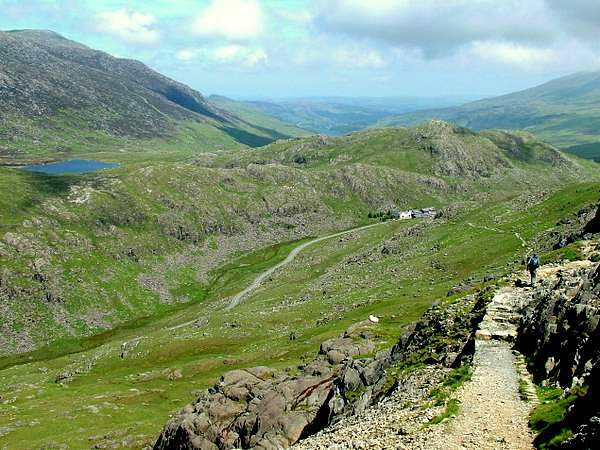
At the Storey Arms (once a pub, but now an outdoor centre), I set off up the hillside towards Ystradfellte. There was a considerable section of undefined route, so I entered a couple of waymarks into my GPS to ensure that I kept on the right track. I stayed on footpaths as long as they were heading in vaguely the right direction, but when it was obvious that they were leading away, I made my way across the open moor, following my GPS. This worked very well and I picked up a footpath to the west side of the valley. There are a whole series of footpaths, mostly sheep tracks, at various levels up the hillside. It is, however, a mistake to go for the lowest ones, as there are lots of little streams running down the side of the valley and the lower down the hillside, the deeper are the valleys that they have carved, and the more awkward they are to negotiate. This is not the easiest area for walking, but I managed to keep up a fairly good pace, arriving in the village at 6.10pm.
My B&B was just down the road from the pub, the New Inn. The only problem was that the pub now only opens on Fridays and Saturdays and even then they don't serve meals. My B&B used to rely upon the pub to serve evening meals for their guests, but when they stopped doing meals, the B&B were faced with the decision of either making meals themselves, which they didn't really want to do, or provide transport to somewhere else. This does not just apply to walkers, but also to people who have driven there but want to have a drink with their meals. They had agreed to make a meal for me, and I had a casserole followed by rhubarb crumble. The village were also suffering with their telephone network, which had been giving problems for months, and there was no mobile reception, so this just added to the problems they were suffering. When I rang to try to book, the phone line was diverted to the mother's phone and she had to pass on messages whenever they could contact her. The public phone box was now out of action and it was suspected that this line had been used to replace someone else's faulty one. There was a desperate need for extra capacity, but BT were not prepared to invest the money to upgrade the lines to the village. I was just about to ask if I could make a call home from the B&B's phone, which was at least now working, when my wife rang through there to check that I was OK.
The telephone and pub problems were just a couple of things causing concern, another thing was the usual problem of rising property prices, putting property out of reach of locals and into the hands of people who wanted them as second homes. As such they were left empty for much of the time, and contributed to the decline of traditional village life. This is all too common in areas of natural beauty, and is the cause of great concern to many rural communities like this one.
After a chat, I went off to explore the Porth yr Ogof caves down the road from the youth hostel, which had recently been closed and sold, presumably to pay for the refurbishment of some other hostel. The river disappears under a large natural stone bridge, reappearing from a large chasm a few hundred yards further downstream. At various places in between there are caves going down to meet the stream, which splits into two or more sections underground. Exploring these caves can be dangerous, with fast flowing currents, and a number of deaths have occurred, so there are notices everywhere warning of the perils.
Day 8 - Friday 10th June 2005 - Ystradfellte to Llanddeusant via Carmarthen Fans
Distance: 15.6 miles - 3,540 ft ascent
Accommodation:
I arose for a good breakfast at 8.00 - the forecast was for a cloudy day, but there was glorious sunshine outside with a clear blue sky. There was no need for a packed lunch, as I would be passing a pub around lunchtime and I also still had a few things left from before. As I started out at 9.00, I entered the grid reference of the river crossing at Blaen Nedd Isaf into my GPS, as I had found route finding through this area of undulating common and fields a bit difficult last time. Even with my GPS, it was still a little tricky, as I was tempted to follow tracks that led off the route until I decided to go in the direction that the GPS was pointing. By this time, though, I had already drifted off course, so just by heading towards my destination didn't put me onto the right footpath, and I had to detour around a little to find the right stiles and gates to get me to Blaen Nedd Isaf (checkpoint 13B at 10.05). This made me realise that putting in a fairly distant grid reference was not as helpful as I thought, because it was still possible to get some distance off course whilst still appearing to be heading in roughly the right direction. It is better to waymark points at shorter intervals so that any deviation from the route is more easily noticed and corrected.
River Neath (Afon Nedd) from Bridge at Blaen-nedd-isaf
After crossing the river, the route was easy to find and well signposted over towards Penwyllt, as it climbed gradually up over the moorland along a grassy track. I stopped for a rest and a drink of water at 10.30 and it was still warm and sunny with quite a bit of light cloud and a refreshing breeze. Here, there were distant views over the moorland and rolling hills north of Ystradfellte. A steady walk took me to the top of the pass, where Pen y Fan and Corn Du had come into sight again. As I made my way further over, the base of Fan Brycheiniog, the highest mountain of the day, came into view, with cloud covering the summit. However, by the time I had reached the other side of the plateau, where I again caught sight of Fan Brycheiniog, the cloud had already dispersed. I had a little problem finding the right path from the quarry at Penwyllt to Glyntawe and this resulted in me going too far down the hill and having to climb back up again to regain the right route. By now, most of the clouds had cleared from the sky and there were some fine views down into the valley and of the mountains ahead.
Fan Hir from above Penwyllt
Cribarth from Penwyllt
Llyn y Fan Fawr from Fan Brycheiniog
I noticed some signposts for the Beacons Way around here, signposting a trail set out by the National Park Authority. I had heard that they had refused to sell Tony Drake's Cambrian Way guide in any of their shops because they didn't want to encourage any more walks over the already overwalked Brecon Beacons, but here they were setting out their own trail to do just that. I can only assume that they had come to realise that it is impossible to discourage people from walking where they want to walk, so they had decided to promote the area themselves and live with the consequences. (I later discovered that this came in response to the damage to the local economy caused by the foot and mouth outbreak in 2001). The only effective way of dealing with the footpath erosion problem is to invest in the building of stone pathways and steps in the busiest places, as has been done in other popular walking areas. This way, a large number of walkers can visit the area with the minimum of damage.
I had been looking forward to my lunch stop at the Tafarn y Garreg pub, which was right on my route, by the side of the A4067. It was 12.30 when I reached there and I decided to have a pint of lager shandy, which would be refreshing on this hot sunny day, without having too much alcohol to sap my willpower when it came to the climb ahead. The first pint went down very quickly, so I had another with my ploughman's lunch, sitting in the beer garden. In this lovely weather, it was tempting to stay for longer, but I urged myself up at 1.30, after a good rest, to head off up into the mountains. There was a steep climb to start with up out of the valley onto the ridge, which was hard work on a hot day, so I just plodded slowly upwards with frequent short stops of 20 to 30 seconds just to allow my heartbeat to slow down a little and to allow more blood to circulate into my leg muscles. It was a relief to eventually reach the ridge, where the ascent was much more gentle and where I was able to progress at more than the snail's pace that I had just been doing, without too much effort. Higher up, there was also the advantage of a refreshing breeze again to make climbing easier.
Looking back across the valley, I could see the rounded mass of Fan Gyhirych and, eventually, the distinctive shapes of Pen y Fan and Corn Du came into view over to the left, now looking more distant. The ridge of Fan Hir (meaning long peak) is just as its name suggests and is a grassy slope at first until the craggy edge that characterises the Fans is reached some way further along. Here, the bright blue lake of Llyn Fan Fawr came into view below. At the end of the ridge there was a small dip before the final ascent onto Fan Brycheiniog and this made a very good place to have a rest at 15.00, with some clouds to the east but clear blue sky everywhere else, giving some marvellous views all around. There was a steep climb at first, but this levelled off towards the summit (checkpoint 14 at 15.40), where an even wider range of views greeted me. Further along, Fan Foel gave me an excellent view of Llyn Fan Fach with Picws Du overlooking it on the left. It is a fabulous walk along the ridge, although there is another steep climb up to Picws Du, but the stunning views all the way along more than compensated for any effort involved.
Llyn y Fan Fach and Picws Du from Fan Foel
Llyn y Fan Fach from Picws Du
Looking back at Llyn y Fan Fach, Cwar-du-mawr and Picws Du
The route I was taking for the youth hostel variant goes right round the end of the lake, whereas the main route drops down into the valley from Picws Du. On a day like this it would have been a great pity to miss this magnificent stretch of ridge walking and, had I been following the main route, I would have been tempted to take this route despite the extra distance involved. After looping round Llyn y Fan Fach, the route drops down to the waterworks track near the lake and follows the stream down past the filter beds where lots of fish were leaping up out of the water. Eventually the track joins a minor road for the rest of the way to the hostel, which is on top of a ridge, so there was a little more uphill walking to do before the day was finished.
The hostel is self catering and is run by volunteer wardens, so does not have a shop. It does, however, have a drying room, so I decided to wash all the dirty things I had been accumulating up to now. The only problem with the drying room was that the only heating was from an electric heater on a fairly short timer, so it required regular trips back into there to keep it going for long enough to get anything dry. My next problem was food - I had planned on going to the Cross Inn at Talsarn, which was about a mile away, but the warden said that it had been closed when he passed there at lunch time. However, there wasn't really much option but to go there and see, as it was quite a way further to anywhere else that might serve food. It is not an easy walk to Talsarn, as the road drops steeply down into the valley and then back up the other side, but without a pack to carry it was so much easier and I made it there in 15 minutes. Fortunately, the pub was open and they were serving food, so all was well and I had a very good lasagne and chips sitting outside on this lovely evening with views across to hills I had been walking. The amazing thing about the walk today was that, even though it was a fabulous day for weather and the scenery around the Carmarthen Fans is magnificent, I saw not one other walker out on the hills, not even across on a distant hillside - I had the whole place to myself. When I think of the masses of people on the Brecon Beacons yesterday when the weather was not as good, it is even more surprising. It just shows how much the majority of people miss because they only ever head for the highest mountain in any particular area and ignore all the rest.
The midges eventually got the better of me outside, so I retired to the bar and had another pint of Wye Valley bitter inside. The pub were selling tickets to the red kite feeding station, as this is the area where they have managed to protect and increase some of the population to the point where they are a fairly common sight. From the information around the pub, I gathered that they were quite actively involved in the red kite programme. As I set off back to the hostel, I was joined by a cyclist (on foot), who was staying at the hostel for the weekend. There was another steep climb back up to the hostel, but not quite as much as the climb on the way there. Back at the hostel, I found that the warden had kindly been pressing the button on the heater in the drying room for me, so I gave it one last press for the night and went to bed.
Day 9 - Saturday 11th June 2005 - Llanddeusant to Rhandirmwyn
Distance: 17 miles - 2,390 ft ascent
Accommodation:
I got up at 7.45 although it was a bit of an effort to force myself out of bed. My washing had dried quite a bit but several things were still quite damp, which is always a problem, as it takes a very good drying room to get everything dry overnight. Much of this is because it is very difficult to squeeze out a lot of the water when washing by hand, and it would be a great help if hostels had a spin drier or even an old fashioned mangle. Some hostels now have a full washer/drier, but often it is not worthwhile when only a small amount of washing needs to be done.
My breakfast consisted of a few oddments I had left - a couple of Welsh cakes, a yoghurt, a piece of fruit cake and water to drink. This is where the lack of a shop in a remote hostel is a letdown. I still had some crisps and some chocolate left for my walk, but there was no problem, as I would be passing through Llandovery by early afternoon. The weather had turned overcast and grey, and was quite cool, but nevertheless I put on some of my damp things so that they would dry as I walked along, and packed the rest away, thinking that I may be able to dry them later by hanging them out around my rucksack.
It was 8.50 as I set off, taking care to find the right path that skirted round the hillside rather than dropping down into the valley, but even then I managed to take a wrong path further on, ending up down by the river and having to climb back up the hillside again to find the correct path. The scenery was now much less mountainous with rolling hills and valleys and not too many steep ascents on today's walk, which would be a bit of a relief. It was very peaceful walking, with only the sound of the birds and sheep until the silence was broken by some loud shouting in the distance, but this was only a farmer calling his sheep dog as they rounded up the sheep.
Route towards Myddfai less mountainous but still attractive
As my breakfast had not been very substantial, I stopped for a rest and a snack at 10.30. I had been rather weary when I set off, but after a while I got back into the swing of things, though I was glad that there would not be too much strenuous walking today. The route to Myddfai follows a meandering path along the hillside, with good views across the valley and to the distant hills. I had to check that I was on the right route from time to time, but it was not too difficult to find the right way. The last mile or so to Myddfai was along a minor road, as was the route up to Myrtle Hill, where I had to check carefully where the footpath went. Around this area I was having great difficulty finding my way, so I was making good use of my GPS to double check my position. I passed through a meadow that had obviously been left to revert to its natural state. It was thigh high in buttercups and long grass, with clover and other wild flowers growing in between. It was very good to see this, but it would have been a problem in the wet, as the path was completely overgrown with all of this vegetation.
All was going well, helped by recent waymarking signs put up by the council, but when I came to a lane that was marked in the guide book as the route and on the OS map as a right of way, the waymarks indicated a parallel path along the side of a field. I followed this for a short way until it turned off sharp left up the hillside, at which point I decided that I must have taken the wrong route and reverted back to the lane. A little further on, I met an old farmer in his Landrover coming towards me and he told me that I was on a private road and that I should have taken the other route up the hill. I was positive that I was on the right route from my position on the OS map, but can only assume that there had been a footpath diversion, perhaps after some right-of-way argument between the landowner and the council. It may well be that the alternative route is a better one but, as I was nearly at the end of the section in dispute, I continued along with the farmer's blessing.
Llandovery
Near the end of the lane, I missed where the track doubled back and had to turn back a little way to find it, at the same time noticing the signs erected by the farmer to say that the lane I had walked along was private. From there on, it was only a matter of looking for the footpath going over the hill into Llandovery. I arrived at 13.15, just in time to catch a fish and chip shop before it closed, but I then had to walk a long way through town, almost out of the other side, before there was anywhere to sit down to eat them. At last, I found a seat opposite the fire station and sat down there. However, I discovered that I had made a mistake with the fish and chips as, rather than being a nice, hot meal to make up for my limited breakfast, they were unappetising, soggy and greasy and I had to throw a lot of them away in the bin. As I rested there, dozens of vintage cars came by, turning down the road to Rhandirmwyn, obviously taking part in a rally. The sun had been shining for a while, but then dark clouds drifted across, so I wasn't sure which way the weather would turn. After a good rest, I was just about to venture on my way when a cyclist came by and said "hello" - he was the one I had met in the hostel last night. He had cycled for about 33 miles and was now returning to the hostel. We chatted for a while before setting off at 14.30 on our respective ways, mine being along the main A483 for a while before going off along a minor road winding its way up Pen y Gaer.
My left ankle had been aching at times, particularly over uneven ground where my foot was twisting from side to side. Despite the fact that I dislike road walking, it did have the advantage that the even surface was less of a strain on my ankle. It was a steady incline up to the top and provided a number of viewpoints over the surrounding countryside which, though not spectacular, was still pleasant with gently rolling hills and valleys, much of the area covered by forestry plantations. After reaching the highest point of the road at 833 ft, close to the summit of Pen y Gaer, there was a steady descent, at first along the road but then following a track for about a mile over undulating ground. At this point, the path was completely missing from my 1:50,000 map though, had I looked on the next map, which overlapped this one, it was clearly marked. However, the route was easy to follow, so its absence from the map was not a problem. Although I had not been pressing on very quickly, I had still made good time, so I stopped for another rest at 16.10 with less than three miles to go. Last time I was around here, I got completely lost and now I could see where I had gone wrong. The guide book shows the route going left at an angle, but the actual path takes a very distinct sharp left, whilst another track runs on ahead, and I had taken the latter.
Pen y Darren, above Nantybai, from across River Tywi
It was not exactly easy finding the right footpaths around here as there had been a lot of temporary footpath signs erected to point out the way, but this assumed that there was only one footpath, which was not the case. I was trying to find the riverside path, but ended up just following the signs for a path some way from the river. It didn't much matter, as I reached the bridge that way by a slightly longer route. At this point I had to decide which way I should go, as I needed to phone home and there was no reception on my mobile phone. I could either stay on the west of the river, going through Rhandirmwyn where there was a phone box on the way to my B&B at Nant-y-Bai, or I could cross to the east side of the river following the guide book route, where there was another phone box near the Towy Bridge Inn, then cross Towy Bridge back over to my B&B from the opposite direction. I decided on the latter, thinking that it would be a better walk by the riverside and would keep more to the route, even though it was a little further. This backfired somewhat, as I was lured away from the river bank by another path which led me back to the road too soon (I missed the note in the guide book saying to keep close to the river). I reached Towy Bridge (checkpoint 15 at 17.50), phoned home, then went up to Nant-y-Bai, where I had a refreshing pot of tea and a shower before returning to the Towy Bridge Inn for a meal. It had turned into a lovely evening; the best part of the day, so I sat outside to have my steak pie and chips until the midges eventually got the better of me and I was driven inside. I returned to the B&B for an early night and was in bed by 9pm, not so much because I was tired, but to rest my legs. Amongst the books in my room was one entitled 500 Mile Walkies, about a man and a dog walking the South West Coast Path, which I read with amusement until I was ready to go to sleep.
Day 10 - Sunday 12th June 2005 - Rhandirmwyn to Pontrhydfendigaid via Doethe Valley and Garn Gron
Distance: 16.4 miles - 2,685 ft ascent
Accommodation:
There were a few others in for breakfast when I went down at 8.00. One couple had done a 22 mile run yesterday and were planning on doing a 10 mile walk today, but the others looked as if they were there for more leisurely activities. After another good breakfast, I set off at 9.15 together with a large packed lunch costing only �3.
The weather was cool and overcast, as I made my away along by the River Towy, partly by road and partly along a track. The large number of trees in the valley obscure the river somewhat, but stretches of it were visible from time to time, as were the waterfalls where it came down from the Llyn Brianne Reservoir, though I couldn't quite find a position to get a good photograph because of the trees. Eventually, the road became a farm track, then a footpath along the hillside overlooking the Doethe Valley. At first there were lots of trees in the valley, but higher up the trees thin out and the river meanders through a craggy, steep sided valley which is spectacular on a clear, sunny day. However, a fine misty drizzle had set in and this took the edge off the beauty of the scenery. My left ankle was giving me a little trouble, but not enough to stop me walking at a reasonable pace - it was mostly over uneven ground and on steep ascents that I noticed it, but I was more concerned about trying to be gentle with it to stop it getting any worse.
After two hours' walking, I stopped for a rest and put on my fleece to keep warm. My plan had been to hang some of my damp washing on the back of my rucksack as I had done yesterday, but there didn't seem much point even though the drizzle had almost stopped. The midges were out in force again, making it rather uncomfortable whilst I was not moving, so I didn't stop for too long. Further up the valley there was a choice of two routes; the main route, which climbs steeply out of the valley to the east, and the hostel alternative, which continues to follow the river up to Tyn-y-cornel Youth Hostel, meeting up with the main route a few miles further on. There is little difference in distance, but the main route has a long, tedious stretch of road walking with not very good scenery, whilst the hostel route avoids the road and stays with the lovely Doethe Valley. If there is any chance to avoid road walking, then I am inclined to take it, so that plus the better scenery quickly decided the matter.
Lower part of Doethie Valley looking South
Doethie Valley looking North from start of hostel alternative route
Doethie Valley on alternative route, with hostel just in view near trees in far distance
The path was rather boggy in places, despite the lack of rain for about a week, but the walk passed easily and pleasantly. Higher up the valley, the scenery is less dramatic, but is still very good, and I eventually passed by the hostel and started to look for a place to stop for lunch with shelter from the cold northerly wind that was blowing. I managed to find a place and there was even the odd ray of sunshine as the cloud started to break up a little. This was altogether much better, but as soon as I continued on from my sheltered spot, I was hit straight in the face by the cold wind, though it was occasionally relieved with some warmth from the sun when it came out. After a mile or so, the track I was following turned to a path, but it was not long before this deteriorated and it was then a matter of following odd sections of indistinct path or sheep tracks across open moorland, with a lot of uneven, tufty grass to contend with. Earlier on, I had thought this route to be far better than the main route, but now I was not so sure. Basically, the main route is better for speed whereas this one is better for scenery, so it depends whether time is of an essence as to which way to take. The best option appeared to be to follow the ridge of small hills where the ground was not so rough, but it still wasn't easy and progress was slow. As I was walking over there I saw a red kite quite close by. In the past when I have thought I could see a red kite, I was never too sure, because they were always silhouetted and in the far distance. This time, however, there was no mistake as it swooped and dived around near enough for me to see its full colouring and markings as well as its general shape.
Ty'n-y-cornel Youth Hostel (just passing by)
Nant-y-maen road junction where hostel alternative route rejoins main route
The weather took a turn for the worse as I at last reached the Nant-y-maen road junction, so I changed into my waterproofs as I set off up the track for the next leg of the route. After a while, I checked with my GPS to see if I had reached the point where I should turn left, but it looked as if I still had a way to go. Further up the hill I took the next left turning and started to look for the path I should take. There were a couple of posts, which looked as if they could be markers, but then there was nothing, so I checked my GPS again and found that I was about half a mile off route - I should have taken the earlier turning. I don't know why I had got the wrong reading before, but I was probably too hasty in taking a reading before it had finished tracking the satellites. I was only looking at a few of the digits to see how far north I was, so didn't notice that it was an old reading I was looking at. At this point, rather than backtrack, I decided to cut across to pick up the correct route. This was a very definite mistake, as I came through some of the worst walking conditions imaginable, with boggy ground and thick clumps of tall grass. If I put my foot on a tuft of grass, I didn't know whether it would bend over one way or the other, and if I put my foot between tufts it may well sink down into a boggy hole. Consequently, I struggled and stumbled along, being tripped up several times by the long grass. After what seemed like an age, I found my way to the path I should have been on. Even then, it was not straightforward, as it was very easy to pick up a wrong path at times, following it until it became apparent that it was going off route, then having to cut across difficult terrain to regain the correct route.
Summit of Garn Gron
The route up to the summit of Garn Gron was equally difficult, with little or no footpath and difficult ground underfoot. I eventually managed to reach the summit (checkpoint 16 at 17.30), with its trig point and large cairn. The weather was still overcast, but there were some reasonably good views from there, though, after the struggle I had to reach there, I wasn't in much of a mood to appreciate them. It had taken me longer than anticipated to get this far, and I still had over three miles to go, so I set the grid reference of my destination at Pontrhydfendigaid into my GPS and was quickly off again over more rough ground from the summit to reach the path leading down. After a while, it became less obvious which path to take and the one I followed seemed to always be heading in roughly the right direction according to my GPS, but I still ended up too far east. This is where I again found that I should not just rely on following the pointer, but should have kept checking the map coordinates to make sure I had not drifted off to one side. Instead of reaching the Afon Fflur river at a footbridge, I reached it further upstream, but managed to get across and onto a track which led to where I should have been. All was well for about a mile when I then had to find the path across to a caravan site near to the road. Again, I had difficulty finding the right path, even by taking careful references from my GPS, and I had to keep cutting across to try to pick up the route again. It appears that, either the path didn't follow the right of way on the map, or it didn't exist, though I may have fared better with the more detailed 1:25,000 map instead of my 1:50,000 one. The guide book does show a more detailed section of the route here, but doesn't show grid lines, so is of little use with a GPS, though it may have been of more use for conventional route finding. In these situations, I am generally inclined to follow the O.S. map but, particularly around this part of Wales, it can be very misleading, as footpaths often do not coincide with the rights of way that are marked on the maps.
All of this trouble with route finding had cost me a lot of time and the rough walking when straying off track had been bad for my feet and for my sore ankle. It was with great relief that I managed to reach the caravan park, half a mile from town and was able to walk on even ground. I was supposed to ring the Red Lion to say what time I would be arriving, as they don't serve meals on Sunday, but had offered to make one for me. I tried to ring on the way down from Garn Gron, but the number was engaged and then I lost reception altogether further down. It was eventually 7.15 pm when I staggered through the door and upstairs to have a welcome shower, followed by some Reverend James back down in the bar, with gammon, egg and chips. I was very tired, so went up to my room to lie down and rest my legs ready for a long day's walk in the morning. It was not long before the good Reverend James rocked me off to sleep.
The big problem with walking in a large area of Mid Wales is that there are not many walkers around, so paths are not well trodden and are often faint and difficult to follow, so are easily confused with sheep tracks, which can lead off in any direction. There is little signposting of footpaths, and stiles are often poorly maintained or non-existent with paths often making use of farm gates instead. As there are many more gates than there are footpaths, it is easy to be confused into thinking that a footpath is being followed when it is merely a route trodden by animals through a field, and it is not until it peters out with no other exit from the field that the mistake becomes apparent. This is a Catch 22 situation, as walkers are deterred from the area by the poor state of the footpaths and the footpaths remain poor because they are not well used. The way out of this would be for the local authorities to waymark paths, but they seem to prefer to discourage walkers anyway, so nothing gets done.
To look at the mileage and ascent for today's walk it would appear not to be too difficult, but these figures do not take into account the difficulty of the terrain. Admittedly, I took a more difficult, if slightly shorter route by Tyn-y-cornel Youth Hostel, and I did stray off the route in places, but it felt like a very hard day's walk, whereas some days that appear to be more arduous on paper, turn out not to be too difficult in practice, especially if they are on good footpaths that are easy to follow.
Day 11 - Monday 13th June 2005 - Pontrhydfendigaid to Ponterwyd via Teifi Pools and Devil's Bridge
Distance: 20.2 miles - 3,090 ft ascent
Accommodation:
A good night's sleep left me fully refreshed, and as ready as on any other morning, to start the day - i.e. it would be very nice to carry on lying in bed, but not too much an act of willpower to get up. The weather was looking reasonable for the moment, and I just hoped that it would stay that way. Breakfast was very large with cereals followed by two eggs, 2 pieces of black pudding, sausage, tomato, bacon, hash brown, beans and toast, and it set me up to face the 20 mile walk I had in front of me.
It was 9.00 as I set off and called at the Post Office for some things for lunch. It looked as if they were closing down, as nearly all the shelves were bare, but I managed to get some Welsh cakes and scones to supplement the things I still had left. The route was well signposted along a path near the river to Strata Florida Abbey, then it followed the road for 1.6 miles before following another well marked path up to Teifi Pools. It was a bright and breezy day with patches of sunshine highlighting the craggy hills of this very attractive area. I reached Llyn Egnant Reservoir at 10.35 and stopped for a short break. I could see the problem with my left leg - there was bruising just above my ankle caused by rubbing from my boots, so I tried tying the laces lower down to allow more freedom of movement to my ankle. After a short distance, I found that it made my ankle worse, not better, so reverted back to normal lacing, but not too tight, and would just have to hope for the best.
As I walked along the reservoir access road, I passed a car with a fisherman sorting out his rod. I may well be the only person he would see there all day, but as far as he was concerned, that was one too many and he studiously ignored me as I passed close by. I have noticed this with fishermen before - they just want to get away from everyone and are seldom inclined to pass the time of day with anyone. Further along there were some lovely views back over the lower set of lakes and reservoirs, although the sunshine had now deserted the scene. A path then goes past a bothy, which had been recently renovated and offered "accommodation to considerate users". From there onwards, the path was less well defined, but it was not difficult to find the way, as I just headed for the ridge above, which had landmarks of lakes on either side to show the way, with the small but distinctive peak of Domen Milwyn as the next point to head for. I saw another red kite, but this time it was not so close, and it was difficult to see its markings, but I could still tell that it was one. The path was quite vague in parts, and the uneven walking was not doing my ankle much good, but before long the walking should get easier.
Route up to Teifi Pools from Tyncwm Farm
Llyn Egnant, Llyn Hir & Llyn Teifi from Waun Claerddu
Llyn Fyddon Fawr, above Teifi Pools
Domen Milwyn is checkpoint 17, and it made a convenient place to stop for lunch, as it was 12.30. There was a bitterly cold wind blowing, which made me put on my fleece and find the most sheltered side of the hill to the east. The visibility was good, and I could see for miles and miles over wild, open moorland. To the north was a large wind farm with 30 or more turbines, all of them stopped. It always seems ironical that when there is a strong wind with the potential to generate lots of power, the turbine blades have to be locked for safety reasons, and end up generating no power at all.
At 1.15 I set off again towards Cwmystwyth, with the weather brightening up again and the walking becoming easier as the paths improved. This was a great relief to my ankle, as my boot was no longer twisting from side to side and rubbing against it. The extra sunshine brightened up the scenery and there were some good views down into the valley towards Devil's Bridge, and of the hills round about.
Despite the better walking conditions, my ankle was getting worse, so I stopped for a while to see if I could do anything about it. It had now become quite sore and swollen, so I tried what I had done before, tying the laces lower down, but this time pushing some padding into my sock to hold the offending side of my boot away from my ankle. This was a great improvement, and was only painful if I twisted or jarred my foot on uneven ground. Otherwise, by taking care how I put down my foot, I could walk more or less normally without much of a problem. There was a bit of uneven ground on the way up the hill from Cwmystwyth, but then good tracks for the rest of the way to Devil's Bridge.
The view overlooking Cwmystwyth
The Arch between Cwmystwyth and Devil's Bridge, built in 1810 to commemorate George III's accession
View overlooking Devil's Bridge
At the top of the hill was a forest trail. I don't normally like forest walks, but the route soon climbed up out of the forest for part of the way, giving some splendid views of the surrounding hills. After re-entering the forest, it descended back out, and crossed the road by 'The Arch', a stone structure over the road, built in 1810 to commemorate George III's succession. Then followed a track alongside but above the road into Devil's Bridge. By now the sun was shining a lot more, though there was still a cool wind. However, the wind must have dropped somewhat, as all the wind turbines were now running. I entered Devil's Bridge by a footpath, having crossed the road a little way above the village, but then had to go part of the way back up the road again, so would have been better off keeping to the road, as I had no need of anything in Devil's Bridge itself.
Soon the route descended into Devil's Bridge Gorge, so I had a rest before continuing. I had to cross the Devil's Bridge Railway on the way down the gorge, and found the gate to a railway crossing, although it looked rather dilapidated and little used. The path from the gate at the other side of the track down into the gorge was also not very well used, but I continued anyway. After a while, it became indistinct and very steep in places making me wonder if I had taken the wrong route. Not wishing to climb all the way back up again, I made my way with some difficulty to the bottom, hoping to find a path along by the river, but there was no path nor anywhere to cross the river. The only option was to make my way along the riverside until I met up with the proper path. This was easier said than done, although it was obvious that a few others had done the same thing. After a very difficult time scrambling through undergrowth and around obstacles on the steep sided river bank, I eventually came to a point where I could proceed no further, my way being blocked by steep rocks on the riverside. The only way to go was upwards, which would not be a bad idea anyway, as it might meet up with the proper path, which should have descended quite a way down the gorge by this point. The climb was very steep, but there were many small trees and shrubs to provide handholds in my scramble upwards until, with great relief, I eventually reached the path and was able to make easy progress along to the bridge. It was still quite a way before I reached the river crossing, so I would have had a very hard time had I tried to continue lower down. As it was, I had wasted quite a bit of time and suffered several scratches on the way. This was quite an exciting interlude, but one I could well have done without towards the end of a long day.
Afon Rheidol in Devil's Bridge Gorge
Having crossed the river, and gone a little way back along the other side, there came the small matter of climbing back up the gorge again. There is a path taking a longer way around which, in theory, gives a view across to the Devil's Bridge Falls, though in practice, the view is rather restricted by all the trees, so I opted for a shorter route directly up to the former youth hostel at Ystumtuen, yet another casualty of the YHA axeman. The track goes unrelentingly up the steep hillside through the forest. It was obviously intended for the use of vehicles, but nothing other than a 4 wheel drive vehicle would have a chance. With several short stops to recover strength, I finally made it to the top, where it levelled out somewhat. Further along I passed the old hostel (checkpoint 18 at 18.05), still displaying its YHA sign despite having been disused for several years. On my way, I was able to see across the gorge to a larger, more recently built, railway crossing, which is obviously the one I should have used. Also, there was a note in the guide book saying not to take the first railway crossing, but this is one of the problems of having notes on a different page from the map section, it is a nuisance to keep pulling out the guide book from the map case to turn over pages just in case there are any useful notes.
Just as I was passing by the old youth hostel, I was met by a flock of sheep being driven towards me along the road. I pulled in to the side to let them by, but the leading ones did an about turn, causing a snarl up in the proceedings. A bit of encouragement from the farmer and his dogs at the other end made them turn again, and they very cautiously edged past me, then ran off down the road. Once they were gone, I was able to continue on the last leg of my day's walk. All that remained was a steady climb up the road, past old mines, to the summit, where there was a great view of Plynlimon and, down below, The George Borrow Hotel, my destination for the night. A path cuts the corner off the road route and comes out right by the hotel, where I arrived at 6.35pm. Pausing for a while to wipe the dried blood from the scratches on my legs from my exploits in the gorge, I checked in. After a shower and some washing, I went down to the bar for a few pints of some very good Buckley's Best bitter and a chilli con carne.
Ponterwyd at the foot of Plynlimon
Although today's walk was over 20 miles, and considering I had a few problems along the way, I arrived in quite reasonable time, and felt a lot better than I did yesterday with less distance to cover. This was mainly down to easier route finding and less rough walking, though there was still some. Apart from the Devil's Bridge Gorge fiasco, most of today's route was fairly easy to follow and quite well signposted, which was surprising for this part of Wales, whereas yesterday' s route was just the opposite, at least for the latter part. It is surprising how much time and effort is lost by even small errors in navigation, especially when this happens time and time again.
Day 12 - Tuesday 14th June 2005 - Ponterwyd to Dylife via Plynlimon
Distance: 13.2 miles - 2,838 ft ascent
Accommodation: Star Inn Dylife
I was a bit late getting up this morning, as I had gone back into a deep sleep until 8.00, so it was 8.15 before I went down for a very good breakfast. There were a few things to sort out before I set off - I had two maps to post back home, and the washing I did last night was still pretty wet. The shirt I normally walked in would soon dry once I put it on, but I packed the rest of the things away, hoping to hang them out on my rucksack once I got up into the hills. The weather was overcast as I set off at 9.20, but the cloud was quite high, so the hilltops were at least clear of mist.
The first short stretch of the route followed the busy A44 road with no verges, so it was not very pleasant as heavy vehicles rushed past only inches away when there were vehicles coming the other way. It was not long, however, before the route took a path towards the B4343 minor road, avoiding the A44 for most of the way to Dyffryn Castell. I followed the path up to the road, which it joined at an angle and I carried on in that direction, blissfully daydreaming and thinking of the day ahead. I was a little surprised that the wind had changed direction to the east, but continued down the road until it merged again with the A44, and I expected to soon see the Dyffryn Castell Hotel appear further along, but then I realised that things were not quite as I had expected - I had joined the A44 from the wrong direction. It took a bit of studying of the map to realise what had happened - I had followed a footpath up to the B4343 and this emerged onto the road in a southerly direction, whereas I should have taken a bridleway which merges with the road further along after a bend in an easterly direction. I had been walking in the wrong direction for about three quarters of a mile, happily relying upon my innate sense of direction. However, it was not a major problem, as I had a fairly short day's walk of about 12 miles, so a little extra didn't matter too much.
Back along the road I saw where I had gone wrong and where I should have emerged, then it was back to join the A44 again before escaping the traffic as I turned off by the Dyffryn Castell Hotel onto the footpath towards Plynlimon. After a short, steep ascent, the path rose more gently for a while before climbing again up a steep hillside, where I saw another red kite in the distance. I stopped for a rest and put on my fleece, as the wind felt quite cold as soon as I stopped walking. When I set off again, I made a wise decision to leave on my fleece, as the heat generated by the steep climb was quickly carried away by the strong, damp, cold wind. The path was not very well defined but was not too difficult to follow on a diagonal up the hillside until it levelled out somewhat as it reached the edge of a forestry plantation. I am not a great lover of forestry plantations, but I was quite glad of this one for the shelter it gave me from the wind. In the other direction could be seen the large wind farm up above Devil's Bridge, and the nearby hillsides were white with cotton grass. As I came towards the end of the forestry, there suddenly appeared a wide, unsurfaced road cutting an ugly scar right up the hillside towards the distant summit of Plynlimon. In places it was wide enough for two large vehicles to pass with ease, and I wondered just what traffic was going to use this and why a much narrower road would not suffice. However, it did provide me with a more even surface on which to walk, giving relief to my ankle which was still uncomfortable over uneven ground.
One of many wind farms in far distance looking back on ascent of Plynlimon from ugly track
Nant-y-moch Reservoir from Plynlimon
Source of River Severn from a peaty bog near Carn Fawr
A while later, the ridge appeared a little way up from the road, so I decided to take that route for the views it offered on the Nant-y-moch Reservoir and the hills towards the coast. The wind was in full force on the exposed ridge, but the views made it worthwhile, even though the whole scene was very grey. A long, gradual ascent led to the summit, where the wind was even stronger, but where there was a very good circular stone shelter for me to stop for lunch (checkpoint 19 at 12.55). My peace was invaded by jet fighters skimming over the hilltops, one of them right above me, but this is very commonplace around the mountains of Wales. I was also surprised by a sudden patch of sunshine and a number of breaks in the clouds, with some areas starting to look quite sunny. Even the Nany-y-moch Reservoir, that had looked so grey only a short time before, now had patches of sunlight shining on it. The wind farm over Mynydd y Cemaes, which I would pass through the day after next, was lit by sunshine and all the rotors were turning, which meant that the wind, though strong, was not excessive. As I looked around I could see more and more wind farms - I counted seven and there was possibly another one just visible.
After an hour's break, I set off for the next small peak along the ridge, Pen Pumlumon Arwystli, which was not much of a climb, as there was only a small dip in between the two peaks. As I walked along the long summit ridge, I kept seeing large slate slabs erected vertically like tombstones with "WWW 1865" on one side and "1865" and a vertical arrow on the other. I could not work out what significance they had, whether it was to mark the watershed, to mark the sources of rivers, or to point to something, I couldn't think what, as the arrows didn't all point towards the same thing, and it is still a mystery to me as to why they were put there.
I had hung out my washing on my rucksack as I set off from Plynlimon, and it was starting to dry in the sun and the wind. The summit shelter of Pen Pumlumon Arwystli made a convenient place for another short break, with far ranging views in all directions, though there were not many distinctive landmarks to identify, other than a lot of wind farms. Looking north, however, I realised that I could see the Aran Mountains and further to the west, Cader Idris. Along the ridge, it is tempting to follow a whole series of marker posts veering off to the right, but I resisted the temptation to follow them and stayed higher up by the fence. After a while, a path of stone slabs leads off to the right, where a large post marks the source of the River Severn, as it emerges from a murky peat bog, showing that big things can have humble beginnings. From here on, the way is even more undefined, and it was just a matter of heading down from the hills across rough country towards the track leading to the Bugeilyn Lakes. All this rough walking was not doing my ankle much good, so it was with great relief that I eventually reached the track and was able to walk on an even surface. From the track, there is a good view across the lakes, actually a reservoir, with a narrow stretch of water connecting the two parts and a bridge taking the track over it to Bugeilyn.
Bugeilyn
Looking back to Plynlimon from Bugeilyn
Overlooking Star Inn Dylife (amidst trees), on descent from Glyndwr's Way
For the first time since setting off up the hill from Dyffryn Castell, I felt warm enough to take off my fleece. There was quite a bit of sunshine, and the wind lower down was not so biting, as I crossed over the bridge to the old ruined building of Bugeilyn. The climbing for the day was not yet finished, as the path then went off over rough ground, up the hillside, then down to where some of the old mine workings could be seen. At this point, I had reception on my mobile phone, so took the opportunity to call home as, quite often, lower down there is no signal. Further down, I was quite surprised to find a National Trail acorn sign on a gateway, but then realised that this was Glyndwr's Way, which had been made into a National Trail a few years ago, and with that came the waymarking. There was yet another climb up a hillside, but it gave some good views across the valley further down, the site of more mine workings. It was such a novelty to find a waymarked route in this part of Wales, that I stayed on it, even though it didn't follow quite the same route as the Cambrian Way. Instead of dropping down into the valley towards Dylife, Glyndwr's Way followed a ridge overlooking it, with fine views all around. As I came past my destination for the night, the Star Inn, I dropped down the hillside and arrived there at 6.15 pm (checkpoint 20). Considering the relatively small mileage I had covered, I was quite late arriving, but much of this was down to slow progress across considerable stretches of rough ground.
When I checked in, I discovered that the bathroom actually had a bath, not just a shower, so I had the luxury of a good, hot soak, which gave some relief to my swollen ankle. The bar opened at 7 pm but, unfortunately, the Abbot Ale had gone off, so I was only left with Tetley's keg bitter to drink with the very good steak and kidney cobbler, chips, peas and salad. The landlady didn't like early mornings, so we agreed to 9.00 for breakfast, though she would have been happy with it later still. It was only going to be a short day again, but I didn't want to make too late a start. There was a couple from Shropshire staying for a few nights, as the wife had a badly broken arm and she was coming for a rest. I chatted with them for a while, and then the bar started to fill up with locals.
Day 13 - Wednesday 15th June 2005 - Dylife to Commins Coch
Distance: 10.5 miles - 1,250 ft ascent
Accommodation:
I awoke to a grey morning following some overnight rain. My ankle, which had swollen up quite a bit by yesterday evening, was looking a lot better now, with just a little swelling and bruising. I was sure it would improve a lot if only I could stay on good, even footpaths but, unfortunately, this part of Wales is not walked very much and, as a result, a lot of paths are poorly defined with uneven surfaces.
My breakfast at 9.00 was of very generous proportions, and I also got a packed lunch, as I would not be passing anywhere where I could buy anything throughout the day. The overnight rain meant that there would be wet grass to contend with, so I waxed my boots. So far, I had managed to keep my feet fairly dry, so I hoped that this would help to keep them that way. Despite the overcast conditions, the weather was fairly mild, the wind having dropped quite a bit. The guide book indicates a lot of the route as being ind (indistinct route) or und (undefined route), which could spell problems both of navigation and for my sore ankle. As there was only about 10 miles to cover, I decided that I would try to tread very gently to help my ankle to improve, even if it did mean I would progress more slowly. Constant checks with my GPS prevented me getting too far off course despite the poorly defined footpaths in places.
It was not long before it started raining, causing me to put on my waterproofs then, as soon as I had got them on, it stopped. Not trusting the weather, I left my waterproofs on as, even if it didn't start raining again, my leggings would help keep the wet grass off my socks. I soon reached a section of ind and und, which was not helped by mist descending onto the hilltops, but I managed to find my way to meet a track at the top of the hill, and I soon came back out of the mist as I descended the other side. Despite the poor weather, there were still some good views of the attractive valleys to either side, even though the distant hills and mountains were in the cloud. A heavy burst of rain came along, but as I looked to the west, some patches of blue sky were heading my way. I stopped for a while, hoping for it to clear up, so that I could take off my waterproofs, which I never like wearing for longer than I really have to. The blue patch came and went, but I decided to tempt providence by taking my waterproofs off anyway. Sure enough, as soon as I had got them off, a shower came along. A section of forestry was close by, so I hastened in that direction for shelter rather than going through the tedious procedure of putting my waterproofs back on. The shower was only short lived anyway, so it was just as well that I left my waterproofs off. As I went through the forestry plantation, I took care that I was following the right tracks by careful use of my GPS which, surprisingly, was not put out of action by the tree cover. As I came out from the trees, I took a slightly incorrect route as I climbed up above the forest, but was soon able to cut across to regain the correct one without any difficulty. It does, however, pay to keep a constant navigation check in areas where the paths are not clearly defined. Another downpour made me stop again to don my waterproofs, as there was nowhere to shelter this time, and I then dropped down to Bwlch Glynmynydd to cross the minor road at its summit there.
Looking NW towards Machynlleth from Bwlch Coch
It was now about lunch time, so I decided to take a break in the shelter of the short stretch of forest plantation, as there were still a few showers. With the overcast weather and the thick tree cover, it was very drab and gloomy, but it did at least protect me from the weather. One of the problems of a short day's walk in poor weather is that it is not very comfortable to spend much time sitting around, yet to press on means arriving at the B&B quite early in the afternoon, long before their preferred arrival time. On a good day, there is no problem, as it is possible to spend a lot of time taking in the scenery and having several rest stops in the sunshine. After a short time I was feeling quite cool, but noticed a few rays of sunshine streaming through the trees, so I took a chance by removing my waterproofs again as I set off along the forest track. Before long, the track emerged from the forest to a lovely sunlit view of the valley to the east, with a slight haze rising from the damp ground. Another ten minutes of walking through the rest of the forest brought me out on its northern edge, but my position didn't quite correspond with where I thought I should be, which meant that I must have taken the wrong track through the forest. I wasn't far off course so, with the aid of my GPS, I was able to find my way along the forest boundary to pick up the rather indistinct path round the head of the valley. Fortunately, I was not tempted along the wide track leading down into the valley, as I would then have had to climb back up the other side onto the next ridge. There was some beautiful countryside around here, with lush, green valleys and a backdrop of distant hills and mountains, but few walkers venture around these parts, as every walk becomes a difficult orienteering venture. Paths marked on the map often do not exist, or are obstructed by wire fences without stiles, or have gates tied up with baler twine. I am sure that the local economy could benefit considerably by encouraging more visitors but, in general, the local councils, often run by farmers and landowners, do not want the intrusion of walkers onto their land, so do nothing to help with the footpaths.
NW from near Maesteg
Commins Coch from felled forestry plantation
The weather had taken a brighter turn, although it was still very changeable, so I took the opportunity to pass a little time overlooking a lovely view during one of the brighter spells. After joining up with the road, I nearly missed my turning up a track at Maesteg, but soon realised my mistake and headed through another forestry plantation to Commins Coch. It is in this plantation that the one and only 'Cambrian Way' signpost that I know of was situated, pointing to a footpath from the forest track down the hillside. However, when I reached the point where the path was, the whole hillside had been felled of trees, and the sign had been lost in the process. It wasn't a problem, as the path was now fairly clear to see, but a pity that Tony Drake's bit of handiwork had gone astray. The advantage of the felling was that it revealed a lovely view of Commins Coch in the valley below. I took another break here, again trying to pass some time before making my way to my B&B at Gwalia up the hillside north of Commins Coch. From where I stopped, I could just see the tips of some of the wind turbines on Mynydd y Cemaes near the start of tomorrow's walk.
The weather started to darken, so I set off again at 4 pm, dropping down into Commins Coch and then up the minor road to Gwalia, where I was greeted with a pot of tea. Another couple, Alan and Pam, were staying the night. They worked for a company who operated guided walks of various long distance trails, including the Cambrian Way, but this time they were undertaking a new walk along Glyndwr's Way. They did this by letting members of the party choose their own accommodation of whatever standard they wished in two centres for each half of the eleven day walk, then transport by local taxi firms was arranged to take them to whatever part of the route they were walking. This part of the walk was based in Machynlleth, so transport was arranged from there. As the two of them were vegetarians, they had found Gwalia from their Vegetarian Handbook, so based themselves there rather than in Machynlleth itself, using their own car to meet up with the rest. Although Alan was the guide, this was the first time he had done the walk, as the cost of a trial run would have been excessive. Glyndwr's Way had been made into a National Trail and officially opened three years ago in 2002 amidst considerable publicity. However, although most sections had been opened and were well signposted, there were still some parts that were not opened because of right of way issues. This meant that today, when they came across a barbed wire fence across the route with a sign saying "This section not yet completed", they had to divert along five miles of road to get round the obstructed part.
We had a very interesting evening putting the world to rights regarding footpaths and walking issues, and were served a very good meal of vegetarian spaghetti bolognese with home grown vegetables, followed by apple crumble. The two of them very kindly shared their bottle of wine with me. Although they had been attracted here because of the vegetarian cuisine, I was here merely because it is a very nice B&B which is very close to the route, and avoids a considerable diversion to any other accommodation. Although Alan prides himself on being very good at orienteering, he had considerable difficulty in these parts, as the paths marked on the map just do not correspond to what is on the ground. Harry Chandler, who holds office in the Ramblers' Association, was out this evening doing some work on his daughter's house (sounds familiar!), but he would have added his vociferous comments about the state of footpaths had he been here. As it got cooler, we kept warm round the nice log fire until it was time to retire to bed.
Day 14 - Thursday 16th June 2005 - Commins Coch to Dinas Mawddwy via Mynydd y Cemaes
Distnace: 11.6 miles - 1,970 ft ascent
Accommodation:
The weather forecast proved to be correct, and I awoke to steady rainfall. My vegetarian breakfast consisted of muesli, boiled eggs and lovely home-made bread, jams and marmalade. For packed lunch I had sandwiches made from the same bread with cheese and pickle. The other two set off at 8.45 to get down to Machynlleth for 9.00 to meet their taxi, but I was in no rush, as I had less than 12 miles to go and I was hoping that the rain might pass over. Instead of the weather improving, the cloud drifted further down the hillside, so I decided that I would just have to pack everything carefully and set off into the rain.
The route started off along Glyndwr's Way until that continued round the bottom of the hillside whereas the Cambrian Way headed up for Mynydd y Cemaes. I got onto a good track which was not quite the right route, as it headed up the mountain at a different angle, but I stayed on it for some way instead of trying to follow some indistinct and uneven footpath. Further up, I took a smaller path, which led to the summit and from there I picked up the wind farm access road. The proper route bypasses the summit and follows the edge of the mountain ridge for some way, presumably with better views from there on a good day but, as the visibility was limited to about 50 yards, I found it easier just to walk through the wind farm on the nice even road surface. My ankle had recovered considerably after the easy day yesterday, so the more even walking I could do, the more it might continue to improve.
The walking was easy along the very flat mountain top, but there was little of interest to pass the time other than counting off the wind turbines to check my progress. Even though I went quite close to them, I could hear them better than I could see them, with just a vague shape being visible for a short time through the mist. I also checked my progress with my GPS, until it was time to head back down from the northern end of the ridge. Here the navigation got a little more difficult, as the last few turbines shown on my O.S. map either didn't exist, or were not in the marked position, but my GPS helped me to find my way down by the side of the forest. This was over rough ground, with no visible path on the ground until I came to the place where I turned into the forest. The route was then waymarked for quite a way, though the path itself was uneven and very boggy in parts, to such an extent that I had water lapping over the tops of my boots at times. This ensured that my feet, which were already getting wet, got completely saturated.
The waymarked bridleway then ascended Esgair Ddu at an angle up the hillside with a gradual slope. Although it is uncommon around here to find a waymarked route, there was a typical example of the disregard for rights of way, as there was a padlocked gate across the bridleway. Further along, the waymarking pointed straight up the steep hillside, where there was no path, whilst the bridleway seemed to go on ahead. I was tempted to carry straight on, but my O.S. map also showed the path going the way that the arrow was pointing, so off I went over rough ground, up the steep hillside. At the top it levelled out onto a horribly rough and boggy plateau. I had to keep using my GPS to find my position, as I spent a lot of time meandering around in the mist, trying to avoid the worst of the boggy areas, so I always seemed to be off course. Eventually, I managed to find a route down the hillside in roughly the right place and, dropping down below the mist for the first time, was able to see a footpath not far away, to take me down the rest of the way. I had a strong suspicion that, had I continued along the bridleway instead of climbing up the hill, I would have reached this footpath by a much easier route. Looking at the map, the distance I had covered over the plateau was not very much, but with the horrible walking conditions and the feeling of being lost, it seemed ten times as far. It also threatened to undo all the good that had been done for my ankle.
Now, at last, I was down onto a farm track, which made life a little easier. I would have liked to have stopped for a rest, but there was nowhere offering shelter from the rain, so I just had to keep on going. The track ran round the hillside, part of the way up, and I am sure it would have given some good views on a better day, but today there was little to see other than sheets of rain and mist over the hills. Further along, the track started to climb up the hillside, which worried me a little, as I didn't expect to have to climb back up again, at least not to any great extent. After a short way, there was a junction and it looked as if there should have been a track running alongside a wall, though it was all very overgrown, so the only route seemed to be the one going up the steep incline. A bit of the way up, I could then see that there actually was a route by the wall further along. By the looks of it, other walkers had found the same problem, as there was a path going back down again to meet the track. Eventually, I reached a sheltered spot under some trees by a stream where I could stop for a break. It was not the best place, but I had been walking for four hours and needed a rest. I ate my sandwiches and a few other things with a little shelter from the rain, but with large drops of water dripping from the trees above I was starting to feel very cold. It wasn't one of the highlights of the walk, to say the least.
Soon I came onto a surfaced road, which at least made the walking easier, even though the weather was still bad. The road eventually came out near the Brigands' Inn, which looked like a good place to get some shelter and warmth for a little break. Although there were boards advertising afternoon tea, the lights were off everywhere and it didn't look much like being open. No doubt if I had gone in and asked, I could have got something, but in my bedraggled state, I decided not to bother and pressed on. A road sign said 'Dinas Mawddwy 1M', but the route via the other side of the river is two and a half miles. As I came close to the second river crossing, I passed by a mill shop with a cafe, so I stopped in the entrance to take off my waterproofs and boots, then went inside leaving wet footprints along the floor from my socks, only to find that they had a power cut and were not even able to offer a pot of tea. I set off again without my waterproofs, as it had just about stopped raining, not that it mattered much, as every stitch of my clothing was soaking wet.
When I reached the Red Lion, I rang the door bell, but nobody responded, and I couldn't see any sign of life when I walked around to the back, so I decided the best thing was to telephone. I had no signal on my mobile, so I walked right down to the far end of the village to where a telephone was shown on the map. I got through and the chap who answered said he had not heard the bell because he was in a flat around at the back, but he would look out for me when I returned after the ten or fifteen minute walk. At last I was inside out of the foul weather and able to have a long soak in a hot bath, which was a change from a long soak from a cold shower that I had endured all day! I then washed out all my things that were already soaking wet, as I had nothing to lose, and hung them around my room to dry.
t was about 6pm when I went back down to the bar and asked if they had a payphone, as I needed to ring home, and was told that the nearest one was down the road. I didn't fancy another long trek to the other end of the village, but was informed that there was one much nearer - I had not noticed it earlier, as it was rather hidden by bushes. That seen to, it was back to the bar for some very good Worthington's bitter and a pork casserole with vegetables and new potatoes, which was also very good. The bar was quite lively right from opening time, and it was good to relax and feel warm and dry after such a miserable day. The bar had a huge collection of horse brasses and other brass ornaments and was everything a good village pub should be; warm and friendly with good beer and good food, making it the social centre of the village. This, at least, helped to make up for all my misfortunes through the day.
Day 15 - Friday 17th June 2005 - Dinas Mawddwy to Penmaenpool via Maesglas and Cader Idris
Distance: 15 miles - 5,096 ft ascent
Accommodation:
Breakfast was at 8.30, so I got up at 8.00 and looked at all my washing that was still quite wet. The weather outside was not too good with the cloud still low and some light rain. The forecast, however, was for highs of 23 degrees after a wet start. I was the only resident and sat at a table in the large dining room looking out at the rain whilst eating a good breakfast. It was obvious that I would have to pack everything well against the rain again, and there was no point in putting on dry things, as they would only get wet, so I donned my damp walking gear with damp socks in my wet boots and put on my waterproofs as well.
It was 9.35 as I set off up the road to where the waymarked path runs up through the forestry plantation. The climb was steep in parts, and it was well worth having on my waterproofs because of the wet undergrowth that I kept brushing against. Although it was wet, it was not cold, so I soon started to sweat with the climb, which meant that by the time I emerged from the forest and embarked upon the more level path round the hillside, I was glad to remove my waterproofs and let the air get to my body.
The path more or less follows a contour round the steeply sloping hillside, and is not very wide, so it was a bit like walking a tightrope trying to keep both feet within the path at the same time. There would have been some good views across the valley were it not for the mist, though the rain had just about stopped leaving only the drizzly dampness from the mist. After a mile or so, and a few awkward bits of path, it started to ascend steeply. I could hear the waterfall nearby but could not see it as the route went onwards and upwards. By now my boots were starting to get very wet from brushing against wet grass and I was accompanied by a squelching noise at every footstep. Further along the path crossed a stream that fed one of the waterfalls, and I could see the water cascading down the steep hillside into the mist below. Route finding was not difficult, as a reasonably defined path made its way alongside the steep cliff side to the right, all the way round the edge of mountain. From then on it was just a matter of following the path, with occasional checks of GPS and map to make sure I was still on track. I kept expecting the mist to lift at any time and was heartened when, occasionally, weak sunshine filtered through and added a touch of warmth. It was not cold, which is why I had left off my waterproofs even though I was getting rather wet from the mist.
After about three hours' walking, I was getting tired and in need of a break, so I stopped for lunch sitting on a stile, which was about the only place other than the wet ground on which to sit. Further on, I eventually got to the point where I had to turn off to drop steeply down towards the A487 road on the way to Cader Idris. So far today I had passed over various mountain peaks and never had a view of more than about 50 yards, but I was still hopeful that the mist would clear before this final, and highest, peak of the day. The path I was on seemed to be taking me somewhat off route, so I headed across rough ground for a way until I met up with a minor road. As I squelched down the road, I could see splashes of water coming out of the tops of my boots at every step - it was a sort of pumping action that was emptying my boots of water, and it continued until my feet were not quite so saturated. This road led me a little way off route again, as I was near a fold on the map and didn't want to get the map wet by opening it out, so I hadn't seen properly where I should have been going. I was dropping down to meet up with the more major road further down the hill, rather than at the top of the pass. Once I realised this, it didn't take long, using my trusty GPS, to head over to where I should have been, though it did mean I had to regain some of the height I had lost.
This route up Cader Idris consists of a few very steep climbs interspersed with long stretches of fairly level, easy walking. The steep parts were very wearing, as I was getting tired and had not had much rest, so progress was very slow, though I could make up for it a bit on the more level stretches. Needless to say, the mist never cleared and the better weather never arrived. The only concession to better weather was that the drizzly rain was not very cold, even high up the mountain. By now my clothing was completely saturated, but I still didn't feel the need for anything more than my polo shirt and shorts, even at the summit of Cader Idris, nearly 3,000 ft above sea level (checkpoint 23 at 4.50pm). From the summit shelter, I had reasonable reception on my mobile phone, so I called home and found that there had been beautiful weather all day along the North Wales coast.
The descent was fairly easy, except for having to take care to avoid slipping on wet stones. The mist remained for quite a way down the mountain side, and even below that it was very overcast with drizzly rain. Probably the best part of the day's walk was the path down to King's Youth Hostel, following the river, where there was at least something to see. I arrived at 6.30pm and was at last able to have a shower and change into dry clothing, having been saturated for most of the day. The hostel did, at least, have quite a good drying room, so I was able to rinse out my wet things and put them to dry with more chance of success than recently.
My next problem was what to eat. Fortunately King's has quite a good shop (and was hoping to start providing meals from 2006), so I was able to get a frozen ready meal of sausages, beans and chips to put in the microwave oven, as well as a couple of cans of Worthington Creamflow. It was not the most appetising nor filling meal I have had, but it sufficed.
This had been quite a taxing day, though not as unpleasant as yesterday, mainly because the route had not been difficult to find, and the paths were quite good for most of the way. Also, my ankle, which I had thought would give me more trouble, was improving and proved to be not too much of a problem. However, it is always harder going in the wet - boots and clothing get heavier, the waterlogged paths are more difficult, rests are short and uncomfortable, route finding is more of a problem because of limited visibility, and more care is needed to avoid slipping on wet ground, particularly downhill. Psychologically, pleasant walking conditions with fine views lift the spirits, and the miles seem to melt away, but when the view is limited to 50 yards and everything is uncomfortable and wet, the miles drag out and seem like twice the distance.
Day 16 - Saturday 18th June 2005 - Penmaenpool to Barmouth via Cregennen Lakes
Distance: 5.6 miles - 700 ft ascent
Accommodation:
There were several hostellers in the main hostel, plus a party of 11 year olds who were sleeping in the annexe but using the self catering facilities in the main hostel. The children were very well behaved and not too noisy, which made a pleasant change. Breakfast was at 8.30 and not up to the standard of a B&B breakfast - the bacon had been frozen and the servings were not very large, but it was adequate. I sat with three chaps who worked for the same company and who were heading up Cader Idris. The forecast was not good for the mountains, with cloud expected over the tops all day, although it didn't matter too much for me, as I was only walking down into Barmouth. There was also another chap there with mobility problems, and he was going to some event in Barmouth.
There had been the odd glint of sunshine earlier but, as I set off to a leisurely start at 9.45, it was overcast with cloud half way up the mountain side. I had gone through the familiar ritual of changing into wet walking gear that had only partially dried overnight. Rain wasn't forecast, so my expectation was that the clothes would get drier rather than wetter as the day progressed. Although I had felt very weary last night, I felt fully recovered again by this morning, but was still glad that I was not facing another hard day. On my previous walk of the Cambrian Way, I had walked from King's Youth Hostel to Cwm Nantcol in one day, and had found it hard going after the previous rather strenuous day. This time I could not get accommodation at the head of Cwm Nantcol, so had over two miles further to walk to my B&B, a static caravan, on the road to Llanbedr. I had, therefore, decided to have a short day of less than 6 miles walking down into Barmouth today, then walking to Llanbedr tomorrow.
There was a steady climb from the hostel, which is tucked deep in the valley, up towards the Cregennen Lakes, which lie on a plateau in the foothills of Cader Idris, and are owned by the National Trust. It was an easy walk on good paths and, for the first time in two days, there was something of a view, even though the mountains were in the cloud. It was very calm and quite humid, and it was such a relief not to be squelching along getting soaking wet. I was even able to take a few photographs, which again I had not been able to do over the last two days. I stopped by the lakes and climbed a little way up the hillside to a rock where I rested, with a view over the lakes and across to the coast at Barmouth. The area around the car park was quite busy, and a number of people were out walking around by the lakes and up on the hills, so it was not as tranquil as it might have been, but still a beautiful place for a break.
Heading towards Cregennen Lakes from Kings Youth Hostel
Cregennen Lakes with cloud still low over Cader Idris and its foothills
Mawddach Estuary and Barmouth from near Cregennen Lakes
I progressed steadily onwards, along the well marked footpaths with views over the Mawddach estuary, to a lovely little bridge over the stream above the Arthog waterfalls, then down a path which follows the stream as it cascades down the steep hillside. Quite a bit of the valley is obscured by trees, but there are still a lot of the cascades and waterfalls that can be seen. Down near sea level at Arthog, a path leads off round near to the estuary, heading for Barmouth Bridge, the rail and footbridge across to Barmouth. The sun was just starting to come through, which enhanced the lovely views, but it did make it hot and sticky with the high humidity and lack of a breeze, so I was glad I was only walking on the flat. I passed through a field with displays of large foxgloves and lilies, before reaching the bank of the estuary, where I found a little hillock to have my lunch break, with a backdrop of the mountains of tomorrow's walk.
Pack Horse Bridge crossing river above Arthog Waterfalls
One section of the many Arthog Waterfalls
Foxgloves and Irises lining path on banks of Mawddach
Although it had been forecast for the cloud to stay low over Cader Idris all day, it had already cleared by 1.30pm, by which time the sun was out fully and I was able to do some sunbathing and to lay out all my wet washing to dry. From my vantage point, I could look across the estuary and watch the seabirds come and go. Some oystercatchers were demonstrating their low flying capabilities over the water, presumably on the lookout for fish, but they never seemed to find anything and resorted to grubbing about in the sand instead. After a few hours of this decadent luxury, lazing in the sun, enjoying the view and relaxing, I decided it was time to continue on my way. All my clothes were now dry, and even my boots were nearly dry, so I took the opportunity to wax them and pack them in my rucksack, as trainers were more appropriate for the walk into a seaside town on a hot summer's day.
Barmouth Rail and Footbridge across Mawddach
Coes-faen from Barmouth Bridge with Diffwys in distance on right
Barmouth overlooked by Cader Idris
The old wooden bridge that takes the railway line across the estuary has a footbridge alongside - cars have to go the long way round via Dolgellau. At the toll booth, where I paid my 60p, I was given a ticket and told I could use it on my way back, but I declared that I was definitely using it one way only - there was no turning back! My B&B was very close to the end of the bridge, and I was given a warm welcome and shown to my very nice en-suite room. My first priority was to do a bit of shopping in town and to top up with cash from a cash machine. I bought some things for tomorrow's lunch, but when I found the Barclay's cash machine it had run out of money, presumably because of all the holidaymakers taking advantage of the good weather. There were other machines in town, though, so I was able to get enough cash to last me for the rest of the walk.
After a shower and a change at the B&B, I went back into town for a meal and had an oriental buffet - as much as I wanted to eat - for �8.95 along with a couple of pints of Old Speckled Hen. Although you might imagine that most people in a busy holiday resort would be strangers, the people sitting outside the pub seemed to know each other and quite a few of the passers by as well. It was one of those perfect summer evenings where the sun was still warm at 9 pm, and everyone was enjoying themselves in a good hearted way. Barmouth is a pleasant town, with a good, sandy beach and the majestic backdrop of Cader Idris though, like most seaside towns, some bits are rather tacky. Days like this are what summer is all about, but unfortunately they are few and far between in Britain. It was still very pleasant as I made my way back to the B&B, having spent some time sitting on a bench near the harbour. There was one price I had to pay for my sunbathing earlier in the day - I had taken off my boots and socks, and my feet and ankles, which had not had much previous exposure to the sun, had got rather sunburnt. This was not a good omen for tomorrow's walk, just when I was getting over the problems with my ankle.
Day 17 - Sunday 19th June - Barmouth to Llanbedr via Diffwys, Y Llethr and Rhinog Fach
Distance: 14.8 miles - 4,118 ft ascent
Accommodation:
I was up at 7.45 for breakfast at 8.00. It was very good with a wide choice of things, and I chatted over breakfast to an elderly couple who were also staying there. They had walked up the Roman Steps from Cwm Bychan yesterday, which is where I would be on tomorrow's walk. The couple who run the B&B are keen on walking themselves, and give a good welcome to the Cambrian Way walkers and others who come their way - they even have a drying room downstairs, though for once I didn't need one.
I was ready and off at 9.00, setting off up the very steep steps towards the quarry at the start of the walk. The weather was somewhat overcast, with cloud lingering around the mountain tops and a lot of haze around. When the sun came through from time to time, it was very hot and sticky and not the best for steep ascents. Route finding was a little tricky, as there are several paths up the hillside and I went a bit off route on my way to the next landmark of the radio mast, but I soon got back on course again. There were some fine views across the Mawddach estuary, though visibility was limited in the haze. From there on, the route was more open as I followed the right of way marked on my O.S. map, thinking that it was the route shown in the guide book. Some while later, when I stopped for a rest, I realised that I should have been higher up on the ridge, and that I had been following the 'February 15th' route, for use when the path along the ridge is officially closed. This did not present much of a problem, as I could just rejoin the main route at Bwlch y Rhiwgyr, a little way further on. This is one of the problems of following a rather sketchy map in the guide book with no grid lines, and a 1:50,000 O.S. map, which does not show as much detail of footpaths as the 1:25,000 maps.
Barmouth Bay from the north with low cloud and mist
Looking East along Mawddach Estuary
Ridge towards Diffwys and Y Llethr climbing into the mist
I was glad to find that the sunburn on my feet was not as bad as I expected and, apart from a little tenderness, didn't present me with any major discomfort. With the steady improvement to my ankle over the past few days and none of the problems of sore calf muscles that I had experienced in the early stages of the walk, walking was now much more comfortable and enjoyable.
At 11.00 I was off again, heading up the hillside for about a quarter of a mile to reach the route on top of the ridge. Views from there were rather limited, as there were clouds lower down towards the sea on one side, and a murky haze with patches of drifting mist on the other. Nevertheless, it was good to be up on the ridge, which presented some good views in itself, both ahead and behind. There is a good feeling about ridge walking, even when there isn't a good view, as there is a feeling that the main climb has already been done, and all that remains are the climbs up and down the peaks along the ridge, which are often interspersed with quite long stretches of relatively easy walking. Even on a clear day, I suspect that the views from this ridge are not as good as might be imagined due to the rounded nature of the ridge though, no doubt, there are some good long distance views over to the Lleyn Peninsula, as well as the views inland across to other parts of Snowdonia. The main thing that kept troubling me was the oppressive heat whenever the sun managed to break through, as there was hardly a breath of air, even on the ridge top, and very high humidity. Further along, as I climbed up higher, I started to come into the mist - at first it was just in wisps, which didn't obstruct visibility very much, and at least managed to cool things down a little.
The summit of Diffwys was a little higher, which meant that it was more completely engulfed in the mist, though there was at least a bit more movement of air. This was one of the few occasions when I have actually welcomed the mist, just for the cooling effect it was having, whereas I normally detest it for taking away the view. At 12.50 I stopped for lunch to eat some of the things I had bought in Barmouth. I was very interested to note that the packet of peanuts that I had bought labelled 'Peanuts Roasted and Salted' had a food warning label on it saying 'Contains Nuts'. Having suitably cooled down to a reasonable temperature, and no longer feeling that I was in a Turkish bath, I set off again through the mist towards Y Llethr, the highest point of the day. I reached the summit (checkpoint 25) at 2.25 pm, although it was difficult to tell exactly which bit of the ridge was the summit. On the way I met a few other walkers; four in total in a fairly short space of time. I had become accustomed to meeting hardly anybody whilst out walking for several days, but it was a Sunday, so there were more people about, even though the weather was not very good. Having had difficulty finding the route down from Y Llethr in the mist last time I walked the Cambrian Way, I had taken note of the paths leading down to Llyn Hywel on a recent walk around the Rhinogs. This enabled me to find the gully referred to in the guide book, which was steep and without much of a path, but which brought me down to meet a path leading to Rhinog Fach, which was just as well, as I couldn't see anything much in the mist to help me find my way. I had been running low on water because of the intense heat earlier on, so was glad when I heard the trickle of a little stream running underground. There was a small hole in the ground where I was able to dip in my cup and have a good drink, making me feel a lot better.
A steep scramble took me up to the summit of Rhinog Fach (checkpoint 26 at 3.35pm). On the way up, I was surprised at how warm the rocks felt - by now it was getting cool, but they had retained the heat from earlier. As this is a very craggy mountain, it is suggested that a descent is made back down the same route as the ascent, then skirting round the base of the mountain to Bwlch Drws Ardudwy, where the path down to Cwm Nantcol can be joined. There was a well trodden path, however, leading straight on in the direction I needed to be, so I decided to take my chances with that. This was fine across the top of the mountain, but when it came to the steep descent to the north, the path just petered out. I didn't fancy walking all the way back, so I was faced with a very steep descent of the heather covered slope. The safest way was to scramble down backwards, but I first took the trouble to pack away my camera and map case so that they weren't dangling in front of me and getting in my way. This way it was not too difficult, though progress was rather slow, both through the heather and over the various rocky sections on the way down. Eventually I reached the bottom of the steep slope and picked up a path for the rest of the way. Most of the paths in this area have to be taken very carefully, as there are lots of stones intermingled with heather making it very easy to twist an ankle or trip over. The only consolation is that the stones are rough and gritty, so provide good grip, even in the wet.
I thought that I had plenty of time, but with the difficult going, it took me about an hour to reach the pass, which was less than a mile from the summit of Rhinog Fach. From then on it was plain sailing, with a relatively good path all the way down to the road. My B&B was over four miles from where I met the pass, so I pressed on at quite a good rate, stopping along the way at a phone box to call home as, needless to say, there was no mobile phone reception down in the valley. There had been oppressively hot weather in the sunshine along the North Wales coast, so I was thankful of the mist that had spared me from that, even though it had deprived me of the views for most of the day. I arrived at my accommodation at 6.15 pm only to find a note stuck on the house door telling me to make myself at home in the static caravan and that they would be back at 8.30. I had been promised a lift to the pub in Llanbedr, two miles further along the road, but if I waited until they returned it was unlikely that I would still be able to get a meal so, after a shower, changing, and washing out a few things, I set off on foot for the pub. It was a pleasant evening, still with a bit of mist around, but generally quite clear down in the valley. It took about 25 minutes of brisk walking to reach the Victoria, which was a large, busy pub with a good beer garden, where I had a Chicken Madras curry and some Robinson's Unicorn bitter.
I returned to the caravan by about 9.30 to find that the couple were still not there, but then about 5 minutes later, there was a knock on my door - they had just returned from a holiday in Portugal and had been delayed. Of course, they had no fresh provisions in the house and there was some confusion as to what would happen for breakfast, and whether I could get the packed lunch I had requested for the day ahead. The caravan was very well equipped, and I settled down for a good night's sleep, hoping that things would work out right in the morning.
Day 18 - Monday 20th June 2005 - Llanbedr to Maentwrog via Rhinog Fawr and Moel Ysgyfarnogod
Distance: 16.3 miles - 3,810 ft ascent
Accommodation:
There was a knock on my door just after 7.30 to tell me that I could have scrambled eggs on toast for my breakfast in the house in 10 minutes time, before Mrs Jones had to leave for work. She had also managed to get things together for my packed lunch - quite a lot of things as it turned out. She didn't want me to pay anything at all, being rather embarrassed by the whole situation, but I insisted on paying so, in the end, we settled on a compromise that the two children should have it as pocket money.
By the time I got going, it was 9 o'clock and I decided that, rather than walk all the way back up the road, I would take a track running from beside the farmhouse up onto a ridge, which would take me up to Rhinog Fawr. For the first couple of miles or so, there was a good track with a steady ascent and, though there was still low cloud lurking around, there were some good views across to the Lleyn Peninsula where the mountain tops were still covered by cloud. As I progressed, the weather improved slightly and the cloud lifted quite a bit. The track came to an end a little way short of the final ascent of Rhinog Fawr, so I had to pick my way as best I could through the heather until I found a path that I was able to follow until it headed off in the wrong direction. By this time, the heather had thinned out somewhat, so it was not as difficult to make my way to where I could pick up one of the main paths leading to the summit. With a path to follow the going was easier, despite the steeper slopes, and I reached the summit (checkpoint 26) at 10.45. This was a convenient place to take a break for a snack and the opportunity to take some photographs now that the mist and cloud had cleared. It was turning into quite a good day with the sun coming out more and more, though there was still some hazy cloud around to restrict the distant views a little. This whole area has a rather hostile appearance, even in brighter weather, with a mixture of bare rocks and dark heather, and very little greenery, though this does lend it a character of its own, and is also a reflection of the difficult walking conditions that prevail.
View west from Mynydd Llanbedr to Moelfre on ascent of Rhinog Fawr
Rhinog Fach and Y Llethr from Rhinog Fawr
Clip and Moel Ysgyfarnogod from Rhinog Fawr
From the summit, I retraced my tracks for a way, until it was time to swing northwards round Llyn Du via a stony route along its northern shore. I was quite surprised to meet a couple of chaps out walking, as I had become so used to meeting hardly anyone, except at weekends. After a little chat with them about the Cambrian Way, I headed over towards the Roman Steps, where I met several other walkers. By now it was quite sunny and most of the cloud and haze had cleared. There was also a refreshingly cool breeze blowing making ideal conditions for walking. The Roman Steps, despite the name, is actually a pack horse route of more recent times, which provides a much easier path than is generally found in these parts. Walking on its large stone slabs allowed me to progress at a much better pace than I was able to achieve over the slow and difficult terrain I had encountered for some while. I dropped down to the path leading to Cwm Bychan, meeting several people on the way, then headed up the steep hillside towards Clip and the ridge of peaks of about 2,000 ft. Near the pass of Bwlch Gwylim, with the biggest part of the climb behind me, I stopped for lunch at 1.30 with a fine view looking down over Llyn Cwm Bychan and across to Rhinog Fawr. Mrs Jones had done a fine job with my lunch. There were four small rolls, a scotch egg, kiwi fruit, apple, two packets of crisps and a kit kat - a bit too much for now, but some of it would keep for another time.
Rhinog Fawr Summit
Gloyw Llyn, Llyn Cwm Bychan & Tremadog Bay from Rhinog Fawr
The Roman Steps, a packhorse route to Cwm Bychan
A steady ascent soon took me to the top of the pass, where a steep climb on the left led up to Clip. The summit is a little way to the south and involves a bit of rock climbing to get there, but the scenery was breathtaking, with a magnificent view over Tremadog Bay and the estuary, to the Lleyn Peninsula, and a whole panorama of mountains from the high peaks around Snowdon to Arenig Fawr, the Arans and back down to Cader Idris and the Rhinogs. Clip may not be a very lofty mountain; in fact its height does not qualify it to be a mountain, but it commands views more spectacular than many higher peaks. I then had to retrace my steps and follow the ridge northwards, which was not an easy task. There are numerous rocky ledges to negotiate along the way, so the path meanders to and fro and up and down finding the easiest route over the obstacles, making progress slow and tiring, but every bit of effort was worthwhile. There were marvellous viewpoints all along the ridge and the ridge itself is very beautiful with several small tarns and many craggy outcrops of rock. The highest point is Moel Ysgyfarnogod (checkpoint 28), which I reached at 3.30. Here the scenery changes from the heather covered, dark, forbidding terrain of the Rhinogs to green, sheep cropped grass with a much more welcoming appearance.
Llyn Cwm Bychan
Arenig Fawr from Clip
Tremadog Bay and Lleyn Peninsula from Clip
Moel Ysgyfarnogod and Foel Penolau
Llyn Trawsfynydd with decommissioned nuclear power station, from Moel y Gyrafolen
After a short break at the summit, where I met a small group of walkers, I set off down towards Trawsfynydd Reservoir, parts of which could now be seen. It was not downhill all the way, however, as there were still a few more climbs up and down along the ridge. The first of these up to Foel Penolau looks far more forbidding than it actually is. It is a large rocky outcrop with steep cliff faces, but an old rock slide in the middle makes for an easy ascent and it is not very much of a climb. From a distance, Diffwys looks like a smooth, round topped, rocky hill that should be very easy to walk over, but it is rather deceptive, as the smooth rock is in ridges interspersed with heather, so it is a little harder for walking than at first sight. Because there are large areas of bare rock, there was little sign of a path, so it was just a question of heading in roughly the right direction and picking up the path at the far end. I reached a very steep rock face going down, so I had to follow this along until I found a route down a steep scramble by the wall. Finally, there was Moel y Gryafolen, which was not much of a climb, but had a steep descent to join the path leading to the side of the reservoir. There were some lovely views of the reservoir from the latter parts of the route, though the now disused nuclear power station is a rather ugly blot on the landscape.
After dropping all the way down to the road that runs not far from the reservoir, the route very soon takes a path back up the hillside again on the way to the dam. Towards the end of a rather hard day's walking it is a little cruel, but is dictated by the rights of way in the area. A steady ascent of about 300 ft eventually brought me to the highest point of the path and then I dropped steadily downwards to meet up with a small road leading to the dam. By this point I could see that I was running a bit behind schedule, so I rang my B&B in Maentwrog to tell the landlady that I would be about three quarters of an hour late, to avoid her getting worried. There remained about a mile of walking through a forestry plantation, which was rather boggy in places, before reaching minor roads for the rest of the way into Maentwrog. Along this final stretch I was feeling rather footsore, which is something I often experience on long distance walks, though I had not had much of it on this walk until now. By the time I reached my B&B, I was heartily glad to give my feet a rest. They had become very wrinkled from being wet, though much of the way had been dry, but a few boggy sections towards the end of the day had obviously taken their toll. Also, the terrain of today's walk had involved far more wear and tear to my feet than the distance would suggest. Although this had been a hard day, it had been rewarded by the most superb scenery, which made up for any difficulties involved and compensated for my recent days in the mist and rain.
After freshening up at my B&B with a shower, I went down the road to 'The Grapes' for a meal and a few drinks. My first pint of Wye Valley bitter was not all that good, so I decided to have the Plassey's Dragon's Breath at 6.5% alcohol. Normally, I avoid high alcohol beers, but I only had to stagger a few yards back to my B&B, so I gave it a try and found that it was a very nice drink as well as being good value, as it was only 5p more expensive than beers at 4.2%. I ordered a Cumberland sausage with saute potatoes at �6.95, which was very good, then settled down to another pint of Dragon's Breath before returning for an early night.
Day 19 - Tuesday 21st June 2005 - Maentwrog to Nant Gwynant via Moelwyn Mawr and Cnicht
Distance: 16 miles - 3,700 ft ascent
Accommodation:
I arose for an 8.00 breakfast, which set me up for the day. There was a complete change in the weather, with overnight rain and low cloud, though it did look as if it might improve with a bit of luck. Starting out at 9.00, I made my way along the road to where a path leads through a nature reserve. It was a little overgrown in places on its way steadily upwards to meet up with the Ffestiniog Mountain Railway at Dduallt. Following the railway line for a while, the route leads through Dduallt Station, where the line does a complete loop to gain height. Further along, by the Tanygrisiau Reservoir, the route departs from the railway with a steep climb up to Llyn Stwlan. There were some quite good views lower down but the cloud was still covering the mountains, though it did seem to be lifting a little. At Llyn Stwlan, which is the upper reservoir of the electric pumped storage scheme, the path seemed rather vague, so I headed for the pass between the two Moelwyns, which was just visible beneath the cloud. From there onwards it was into the mist for another steep climb up Moelwyn Mawr. When I thought I was nearly at the summit, I found that the path dipped a little for a few hundred yards before coming to another steep climb to the summit itself, which levels out to a rounded, grassy hilltop (checkpoint 30 at 11.55). The view was much the same as I had experienced in a number of other places - 50 yards in any direction, as I stopped for a break, sheltering from the cool, damp wind by the trig point.
Waterfall near Dduallt
Tanygrisiau Reservoir lower part of pumped electric storage scheme
Llyn Stwlan Dam upper reservoir for pumped storage scheme
There had been a lot of steep climbing on the way up, but then this wouldn't have been chosen as a pumped storage site had it not been for the steep drop from one reservoir to the other. After half an hour at the summit, waiting for the mist to clear, I was shivering with the cold and was just about to set off again, disappointed with the lack of a view, when suddenly the clouds parted for a brief time to reveal a view to the coast, as if by magic. Other views kept coming and going as gaps appeared in the cloud - this is one of the few good things about mist; the sudden transformation of the scene from a grey nothingness to a wonderful view within seconds. I stayed for a while longer, taking in some of the views that appeared before making my way down to the huge complex of old quarries and quarry buildings. From there it was a steady climb back up through an attractive area scattered with small lakes to pick up the northern end of the ridge leading to Cnicht. I managed to find a reasonable path for most of the way, which was just as well, as it is easy to get disorientated with all the ridges and general undulations of the land. Cnicht was still in the cloud, as I made my way along the ridge, following an easy path, with some good views appearing from time to time. However, as I approached the summit, the cloud started to lift and I was able to see several people on the top from one of the earlier 'false summits' that I had reached. Suddenly there was the sound of cheering as, I presumed, the last of the party reached the top. When I reached there myself (checkpoint 31 at 14.20) I discovered that it was a group of children supervised by a couple of adults. The cloud kept coming and going from the summit as I stopped for a bite to eat and a rest.
View east from summit of Moelwyn Mawr with mist just clearing
Looking down tramway to old quarries North of Moelwyn Mawr
Looking back North from summit of Cnicht with Llyn Biswail and Llyn yr Adar
At 14.45 I started my descent down the steep side of Cnicht, which is often known as the 'Welsh Matterhorn' because of its appearance from this side, although it is on a much smaller scale than the real thing. As I descended a rather awkward rock face, I passed by the party of children and also another group who were just about to climb up. I got the impression that I had taken a more difficult route than I might have done and I carried on down the steep descent, rather than making my way round to where the others were. I soon realised that this was the wrong way, as I should have stayed higher up on the ridge but, by making my way down the grassy hillside which, for once, was quite easy, I was able to pick up the route further down. There followed a couple of miles of very easy walking with views down towards the coast and also looking back to Cnicht from its Matterhorn perspective. Then came a stretch of road walking involving a few ups and downs, with views of Moel Hebog and the mountains south of Beddgelert, before reaching the Aberglaslyn Nature Reserve, owned by the National Trust, where the route follows the river up to Beddgelert
Looking back up at Cnicht (The Knight), also known as the Welsh Matterhorn
Afon Glaslyn on way to Beddgelert
Afon Glaslyn above Beddgelert with Moel Siabod in view
Aberglaslyn is a very picturesque stretch of the river with crystal clear water flowing over a series of rapids and small waterfalls, but the path is not very easy at the start, where it has to follow the rocky riverside by Aberglaslyn Pass. Nearer to Beddgelert, the path was much easier, and I was able to progress at a better speed. Beddgelert itself was busy with holidaymakers on, what was now, a sunny afternoon as I passed through to find a phone box to call home. My wife plus a couple of long term residents of our hotel were travelling down later in the evening to take me out for a meal, as I was now within about an hour's drive of home. I confirmed that I was on schedule for them to pick me up at about 7pm, as I expected to arrive at the Bryn Dinas bunkhouse, three miles north of Beddgelert, by about 6.15pm. There is nothing near Bryn Dinas to provide food or drink. The house there is a residential centre for parties, but does not provide meals for others, for whom only self-catering facilities are available. Were I not to be taken out for the evening, I would either have had to eat early in Beddgelert on my way through, or bought things to cook for myself at Bryn Dinas.
The last part of the walk followed the eastern side of the river, first along a road, then a footpath past Llyn Dinas with a backdrop of the foothills of Snowdon (the summit being hidden by the lower slopes), Crib Goch and Moel Siabod in the distance. After a shower, doing some washing, and sorting out things to send back home, I waited by the roadside for my transport to arrive. Soon I was on the way to Beddgelert to the Royal Goat Hotel for a very good meal and an enjoyable evening, until my wife and friends had to set off back. This made a very pleasant change from most of my evenings when I only had myself for company.
When looking at the individual days of a long distance walk, it is not easy to tell just from the distance and ascent, how difficult the walk is going to be. Yesterday's walk and today's walk were of a similar distance and ascent but, without a doubt, yesterday's walk in Rhinog country was far more taxing because of the more difficult walking conditions in many parts.
Day 20 - Wednesday 22nd June 2005 - Nant Gwynant to Idwal Cottage Youth Hostel via Snowdon and the Glyder Mountains
Distance: 11.8 miles - 5,820 ft ascent
Accommodation:
There were quite a lot of clattering footsteps at about 6am, presumably because some people were off to an early start for some challenge walk or other. I got up at 8.00 and found that there was quite a to-do, as someone had broken into a car parked by the roadside in the night, leaving lots of things strewn around nearby. It turned out that it belonged to one of the workmen who were refurbishing the facilities at Bryn Dinas. The rubber seal round the rear passenger window had been slit, allowing the window to be removed, and the intruders had gone through everything in the car. The strange thing was that, although there were a lot of expensive tools and other items in there, nothing had been taken. Later it was discovered that a similar thing had happened to a minibus belonging to a school party who were staying in the house at Bryn Dinas and, once again, nothing had been taken, presumably because the thieves were looking for cash or other valuables.
I made myself some toast and tea, and had a packet of muesli for breakfast, then packed my things ready to be off. Most of the people using the bunkhouse accommodation were workmen, either working on the refurbishment, or working on various projects around Snowdon, although there was an Australian chap and another girl who were off walking. I had sent as many things back home as I could to lighten my load, but found that the food that I had been brought far outweighed anything that I had sent back, so I had an even heavier pack for my strenuous day ahead.
I was off at 9.20 and joined the Watkin Path just along the road, climbing steadily up past a series of waterfalls and old quarry workings before turning over to the left to head for the Allt Maenderyn Ridge. This route is recommended as, on a clear day, it offers better views than the Watkin Path and it also avoids the rather difficult, badly eroded scramble near the summit. Today, however, the cloud was down to the level of the lower part of the ridge, so I was not expecting to see anything for the rest of the way. Just below the cloud, I stopped for a rest at 10.35, sheltering from the cool wind by a wall. I passed three workmen on the way up doing path repairs using tons and tons of stone - they reckoned it would take a few months to complete this relatively small section. Where I stopped was about half way up Snowdon as far as altitude was concerned, and I started off again up the steep ridge path into the mist. After a while the slope eased off to a more gentle gradient as I continued with visibility of about 50 yards that is generally associated with mist. About half an hour later, I checked my progress with my GPS and was quite put out when the altitude reading was only 650 metres, whereas it had been 530 metres where I stopped. However, the reading kept jumping up in large amounts until it finally settled at 815 metres, which was more what I had expected and a lot more satisfying for my efforts. The reason for this is that, in the earlier days of satellite navigation, the military introduced a deliberate wobble into the signals, so that only they could obtain maximum accuracy by compensating for the error. This had an effect, particularly on altitude readings, like being on a roller coaster even when standing still. Some GPS units, therefore, averaged out altitude readings over a period of time in order to give a steadier display value. Even though the wobble has now been removed, the averaging out means that it takes some time for the altitude reading to settle to the correct figure.
Waterfalls beside Watkin Path up Snowdon
Llyn Cwellyn through clouds from Snowdon summit
Snowdon Mountain Railway, Llanberis and Llyn Padarn
I pressed on at a steady rate onwards and upwards for a while, seeing only a few people along the way, when suddenly a patch of blue sky appeared and the summit cafe just ahead was briefly bathed in sunlight. I continued on up to the viewing platform at the summit (checkpoint 33), which I reached at 12.00, almost to the second. From time to time another patch of blue sky would appear overhead and sometimes a brief view opened up below. When this happened, it was like looking out of an aircraft from just above the clouds with glimpses of the valley beneath. I stayed for a while trying to get a photo, but then retired to the warmth of the cafe and a cup of tea. Whilst I was still sitting there after drinking my tea I saw out of the window that the clouds were parting again and giving better views than before, so I dashed outside, camera in hand to try to capture some of this. There followed a period of fantastic scenes as the mist came and went, with clouds racing across the mountain side and fabulous views down between them. It was all changing so rapidly and was far more dramatic than had there been a clear sky. All of this took place on the western side of the mountain; the eastern side having more persistent cloud.
Descent of Snowdon down Pyg Track with Glaslyn and Llyn Llydaw
Llyn LLydaw from Pyg Track
Glyder Fawr and Glyder Fach from Pyg Track as it approaches Pen-y-pass
When I first reached the summit, there had not been very many people around, but now they were coming in droves - not quite as many as on a weekend, but still a lot. I made my way down the Pyg Track, as I didn't want to spent too much time and energy on the Crib Goch route, with the Glyders still to climb before the day was done. The lower route of the Miners' Track is quite a good one, but the last stretch from the lakes to the Llanberis Pass is not as good for scenery as the higher route taken by the Pyg Track, which also gave me a good view of where I was going next, Glyder Fawr and Glyder Fach. By now most of the cloud had cleared with just a little still clinging to some of the higher mountains in places, making it a wonderful afternoon for walking. I reached the Llanberis Pass at 2.25 and decided not to rest there but to make a start on my ascent of Glyder Fawr until I was feeling tired or thirsty or both. Unlike the routes up Snowdon, the path to Glyder Fawr from this side is not so well defined, and I strayed off along a path running too low down to the west. To be more truthful, I kept taking the easiest path as I went along, skirting round the mountainside rather than heading upwards, in the vain hope that an easy path would lead me effortlessly to the summit. This, of course was not to be, and it then necessitated a steep climb up the grassy hillside to rejoin the proper path, which was a hard going at this stage of the day, so I stopped for a well earned rest with Crib Goch towering majestically above me across the valley. Refreshed a little, I continued onwards and soon regained the path where, after a few more steep climbs taken at a steady plod with frequent pauses to regain my strength, I finally came over a ledge where the whole summit ridge came into view. It was farther away than it looked in the clear, sunny conditions but at least the way was now considerably less steep. I reached the summit of Glyder Fawr (checkpoint 34) at 4.20 with a spectacular panoramic view of mountains and valleys.
Pen-y-pass from Pyg Track with Llyn Cwmffynnon
Pass of Llanberis down Nant Peris to Llyn Peris
Llyn Cwmffynnon and Llyn Lockwood from ascent of Glyder Fawr with Moel Siabod to left
<
Crib Goch with Snowdon behind and Y Lliwedd to left
Y Garn from Glyder Fawr with Elidir Fawr behind
Llyn Idwal, Nant Ffrancon and Menai Strait from Glyder Fawr
The Glyder Mountains themselves look more like a huge pile of rocks that some giant has carelessly scattered in untidy heaps. Hardly any vegetation manages to grow, as there is little soil to be found, but some of the views from here are second to none. Glyder Fawr is quite stony, but Glyder Fach is even more so, with huge piles of large rock slabs and boulders which have to be negotiated as well as the pile of boulders that form the summit itself, making it far from easiest summit to climb if the highest point is to be reached. I arrived there (checkpoint 35) at 5.15 and met a chap who was struggling to make his way over the last couple of boulders to the top. I passed him by, so he then followed my route up. There were a few people around, but nothing like the hordes who were swarming over Snowdon, making it far more peaceful. Amongst all the rocks and boulders around Glyder Fach is the famous Cantilever Stone, a large stone slab balanced almost in the middle. I was up here on a previous occasion when a group of five or six people stood on the end of this and jumped up and down in unison, making the huge stone rock on its pivot. So far nobody has managed to get enough people on there to make it overbalance, but it may just happen one day.
Cantilever Stone on Glyder Fach
Tryfan and Carnedd Llewelyn from Glyder Fach with Ffynnon Llugwy Reservoir just visible
I didn't stay long, as time was marching on, so I made my way along to the suggested route for the descent. The more frequently used route is down a badly eroded steep path towards Tryfan, but the route in the guide follows the ridge for a while further, then doubles back down a less steep but still quite badly eroded path leading to Bwlch Tryfan, the pass between Glyder Fach and Tryfan. From the pass, there is a well-used path, paved most of the way down to Idwal Cottage youth hostel near Llyn Ogwen. The weather had been just fantastic for the latter part of the day and, though this had been a physically demanding day because of all the ascent, I had not found it too hard going, though it was 6.45 before I arrived at the hostel.
The hostel is self catering only, but they have a well stocked shop, from which I bought a frozen beef stew with dumplings, some microchips, a large Eccles cake and three cans of Guinness - thank goodness the YHA are no longer TT. After dinner, I took a little stroll by Llyn Ogwen with Tryfan still fully lit by the evening sun. Sunset comes early in the valley in the shadow of the mountains, so by 8.30 the sun had gone and it started to get cool, whereupon I returned to the hostel to have an early night after this tiring but very rewarding day.
Day 21 - Thursday 23rd June 2005 - Idwal Cottage to Rowen Youth Hostel via Carneddau Mountains
Distance: 13.5 miles - 4,388 ft ascent
Accommodation: YHA Rowen
I awoke quite early to sunshine streaming through the window, but lay in bed until 7.30 when I decided to get off to a reasonably early start. By the time I had made my breakfast of muesli, tea, toast and marmalade, sorted out all my things and so on, it was 8.45 before I departed. One good thing about yesterday's walk was that my feet had kept dry on the good paths, and the new pair of walking socks I had put on were still clean and dry. A couple at breakfast had attempted the three peaks - Ben Nevis had its top half in mist (nothing unusual about that), Scafell Pike they climbed by night but gave up half way when they met up with the mountain rescue team bringing down an injured walker, then they climbed Snowdon with the top half in mist. They had seen very little on the whole trip, except that they had some views from Snowdon on the way down, after the mist had cleared, and they hadn't even managed to complete the full challenge walk, so they were rather disillusioned with the whole thing.
It was a brilliantly sunny day and already quite hot down by the lake as I set off. Instead of taking the very steep path directly up Pen yr Ole Wen, the route takes a path round the north side of the lake, which is not all that easy going with a lot of scrambling round rocks, boulders and bogs until the far end of the lake. From there a path waymarked with posts leads up the hillside and this is the location of checkpoint 36 (reached at 9.15) which ensures that Cambrian Wayfarers do not take the steep route. Though fairly steep, this route is not too difficult and I managed to keep plodding on upwards without too many stops. I passed a Scottish couple who were headed in the same direction, albeit at a very slow pace, and also a few other walkers, one of them already coming back down. It was hot work, but gradually a cool breeze came to improve matters, as I climbed up higher. I was looking for a pleasant place to stop for a break and found one overlooking the little tarn of Ffynnon Lloer. When I came to continue my way, I realised that I should have gone up the ridge rather than skirting around the side, so I was faced with a very steep scramble up a gully for several hundred feet to reach the top of the ridge. It was not the easiest ascent, to say the least, but eventually the end was in sight and I regained the easier path onto Pen yr Ole Wen, where I stopped to chat with an elderly chap out for a few days' walking. He had just bought a GPS similar to mine, except that it was the more expensive model which allows maps to be downloaded. For what he wanted - i.e. grid references - the cheaper model would have been just as good for half the price, but he thought he was buying the best, even though he had no intention of using the extra facilities.
Idwal Cottage and Y Garn from Llyn Ogwen
Ffynnon Lloer on ascent of Pen yr Ole Wen
Llyn Bochlwyd & Glyder Fach from Pen yr Ole Wen mountain rescue helicopter is dot above
There was a lovely clear view of all the high mountains, but many of the lower mountains in the distance had cloud hanging around them, as had most of Anglesey, which was the opposite of what is normally encountered. After a while I made my way over to Carnedd Dafydd (checkpoint 37 at 12.05) and then on to Carnedd Llewelyn (checkpoint 38 at 12.55). The going along the ridge was quite quick and easy for most of the way, the only difficulty arising from a few areas where scattered stones and boulders have to be traversed with a great deal of care. There were a few people about today, but it was still very peaceful. Between Carnedd Dafydd and Carnedd Llewelyn there is one of my favourite views down the valley to the north west. There is a steep craggy drop down to a stream that meanders its way down the huge round bottomed valley. As is the case with many fine views, it is very difficult to capture the full impact on a photograph - there is nothing quite like being there, but then, if it were possible to experience the full beauty of the mountains from an armchair, it would detract from the pleasure of actually being up there.
Nant Ffrancon and Y Garn with Snowdon behind
Afon Llafar and Bethesda from Cefn Ysgolion Duon, between Carnedd Dafydd and Carnedd Llewelyn
Me on summit of Carnedd Llewelyn, with Carnedd Dafydd and Elidir Fawr behind I don't like selfies very much but have allowed myself a couple! (At the time this was written, I didn't even know what a selfie was!)
I stopped on Carnedd Llewelyn for lunch, still eating things that my wife had brought on Tuesday, and probably still having things left by the end of the walk. A few walkers came by the summit but, for a long time, I had it all to myself. After about 35 minutes I decided to press on, as I still had quite a long way to go. The whole landscape now changed from the stony mountains, often with steep cliff faces in parts, to a series of rounded green hills and valleys leading away to the coast. Even though the ridge was still at about 3,000 ft above sea level, it no longer gave that impression, although each summit along the ridge had its obligatory pile of stones at the top; the piles getting less and less at each one. The high ridge culminated at Foel Fras, a very level topped mountain beyond which was a fine viewpoint for the North Wales coast, from Anglesey and Puffin Island to the Great Orme and Llandudno, and around to Rhyl in the hazy distance. I could see the wind farm a few miles out to sea near Prestatyn, though it looked nearer to Colwyn Bay from this angle. I checked with my guidebook to see how far I had to go and was surprised to find it was only five and a half miles - I had been thinking that it was further than it was.
With time to spare, it seemed like an ideal opportunity to do a spot of sunbathing. The trouble was that the moment I took off my shirt, I was surrounded by swarms of small flies. Just then I noticed that the spot I had near my waist had something black in it. On closer inspection I found that it was a tick with its head and claws firmly digging into my flesh. The ideal treatment is strong alcohol, which kills them off at the same time as relaxing their muscles enabling them to be removed easily. Attempts just to pull them out often result in bits being left behind which can turn septic. Not having any strong alcohol with me, I decided to dig it out using the pointed blade on my pocket toolbox. This appeared to do the trick and I could not see anything left behind, so I put on some Savlon cream and hoped that would be the end of the matter.
Llyn Anafon and coast from descent of Foel Fras, with Anglesey and Puffin Island in view
Conwy and its Castle from Tal y Fan
As soon as I put my shirt back on, most of the flies disappeared - you just can't win! From here on it was goodbye to the 3,000 ft mountains as I dropped down to Drum, still a mountain at over 2,500 ft, but looking quite lowly from above. An easy path led down over a series of lower peaks to Bwlch y Ddeufaen, the pass between Drum and Tal y Fan. At the end of the day, Tal y Fan is a rather cruel hill. Firstly, it has a very steep ascent up to Foel Lwyd, the first peak along the ridge, followed by a series of ups and downs over crags for a mile before the summit of Tal y Fan itself reached. There were some good views from there (checkpoint 37 at 17.30) down to the coast and over the Conwy Valley, with Conwy Castle, the end of the way, in sight. From the summit it is again not easy, as the ridge continues a roller coaster route before dropping down at the end.
I was a bit too busy ringing home to check properly on the detour from the main path to Rowan Youth Hostel, so when I eventually did so as I reached the old mine workings, I found that I had overshot and needed to cut back across sharp right. Unfortunately, this also involved climbing back up somewhat over the ridge. The final insult was, having found the footpath leading directly to the hostel and with the hostel in my sights only about 50 yards away, there was a barbed wire fence blocking the path with waymarks pointing both up and down the steep hillside. As I was on a level with the hostel, I was not sure which way would be easiest. I tried uphill, but with no route to the hostel in sight, I went back downhill until I met a track which joined up with the steep road to the hostel. It was not very far back up, but it felt like it at the time, so I was glad when I had finally managed to stagger up the road to reach the hostel at 6.30. There were notices all around warning not to drink the water, but there was a plentiful supply of free mineral water in the fridges, which I availed myself of in large quantities to quench my thirst.
The hostel was being run by volunteer wardens; the couple at the time being there for just a week. This is one way of keeping remote hostels open, as it saves money on wage bills, but hostels do lose quite a bit by not having a regular warden. This hostel did, at least, have a limited shop but, as I scanned the cans of beans and soup on the shelf, it made me wonder if there was anything there from which I could make a reasonable meal. My other option was to walk about a mile to the nearest pub. Now this may sound nothing excessive, except that it is a mile down a very steep hill, dropping over 600 ft in the process, which is easy enough going down, but is a hard slog coming back up after a meal and a few pints. After a hot day's hard walking, the option of a decent meal won me over; I would just have to put up with the climb back up when it came. A good shower freshened me up after the hot day's walk, and I then rinsed out my walking shirt, which was saturated with perspiration.
The road down was indeed very steep in places, as I made my way to the first pub I could find, the Ty Gwyn Hotel, where I had some very good Lee's bitter and a chicken and cider casserole with mash. It was warm outside in the evening sunshine, so I sat on a bench in front of the pub and felt as if I could happily fall asleep there. There was also a very pleasant beer garden across the road by the river, so I went over, only to be repelled by the midges in a very short time, making me return to the bench.
There is a lot to be said for psychology. I had been building myself up to a very long and hard walk back up to the hostel, but when I came to do it, it was a lot easier than I expected. It was still a hard slog, but without my pack and in the cooler air of the evening, I just kept up a steady pace and, far sooner than I expected, the hostel was in sight. There is a lovely view across the Conwy valley from outside the hostel, so I sat outside for a while until the dreaded midges got the better of me again. This had been a wonderful day's walk, and a marvellous finish to the Cambrian Way. I say that having not quite finished but, whatever the weather tomorrow, it is less than half a day's walk down to Conwy Castle, and no high mountains to contend with, so I now had the feeling that the walk was virtually over.
Day 22 - Friday 24th June 2005 - Rowen Youth Hostel to Conwy (End of Walk) via Conwy Mountain
Distance: 6.4 miles - 909 ft ascent
Although I had only a short way to go, I made a fairly early start by getting up at 7.15, as I wanted to be in good time for my daughter Jen to pick me up from Conwy Castle at 11.15. I didn't have much for breakfast, but I made some tea and ate up some fruit cake from my packed lunch leftovers. There were a couple of Australian ladies staying at the hostel, touring the area by car, and a few others including one chap from my dormitory who was still in bed. As I was packing up my things at 8.00, the fire alarm went off - one of the Australians had set it off whilst making toast, so anyone still asleep got a rude awakening.
Craig Hafodwen and Foel Lus (hills bordering coast) from North Wales Path near Maen Esgob
Conwy Castle from descent of Conwy Mountain
I managed to get off at 8.15, more or less retracing my route back to the standing stone near the old mine workings. It was rather grey and overcast but not cold, and I got quite hot climbing up the steep hillside until it levelled out a little and the walking became easier. Once I had rejoined the main route there was some very quick and easy walking along the common on a soft green track giving a constant view of Conwy and its castle gradually getting nearer and nearer. It all looked quite drab in the dull weather conditions and not a bit like it did in yesterday's sunshine. After a while, the route swung away to the west side of the common, giving views of the hills that line the coast, and joining up with the North Wales Path, which is well signposted. I stopped for a break at Pen y Sychnant, overlooking Conwy Mountain with about three miles left to go. From there was a drop down to the Sychnant Pass itself, part of the road built by Thomas Telford, and then on to the last climb of the walk, up Conwy Mountain, an old hill fort commanding fine views over Conwy and across to Llandudno, though a couple of large static caravan sites mar the view in places. Despite the 'mountain' in its name, this was hardly a climb at all compared with those along the way, and I reached the summit (checkpoint 40) at 10.45.
Conwy Town Walls - Almost There!
Finish of Walk at Conwy Castle
At the finish of the walk by Conwy Castle, ready then for home�
An easy, grassy path led me down into the town, with good views overlooking the town and castle along the way. I was soon entering the town through its well preserved town walls, then to the finishing point at the castle (checkpoint 41 at 11.05). My daughter Jen soon arrived to collect me and take me back home where a welcoming party of family, people from the hospice and other friends, who were gathering for drinks and a buffet lunch. As everyone eventually drifted away, it was back to reality and back to work again, catching up on outstanding jobs.
Thoughts at the End of the Walk
All in all, this had been an excellent walk, although I did have a few days in the mist and rain, which is only to be expected from a mountain walk lasting for three weeks. In contrast, I had had some spectacularly good weather on quite a few days, which showed the magnificent scenery at its best, more than compensating for the bad days, and confirming to me that this is the best long distance walk that I know of in Britain for scenery. I was particularly glad that I had managed to have good weather in some of the places where I had missed the scenery last time I did the walk, especially the latter part of the Black Mountains, which was a great pity to have missed before. Some parts that I missed this time because of bad weather, I had seen on other occasions, but there were still a few parts where the weather was bad on both walks. One of these was on Blorenge, another on Mynydd y Cemaes, and another from Barmouth to Rhinog Fach, so I will have to make another visit to these some other time to see what I missed.
I did manage to fare considerably better with my navigation on this occasion, partly because I had done the walk before and could remember some of the places where I had lost my way, and partly because I had a GPS to help me this time. However, this is still a walk which requires constant vigilance to keep on the right route, particularly through mid Wales. There were places where I had found my way last time but went off the track this time - it is not easy to remember the whole route from some years ago, though it does help quite a bit. The problem that sometimes can occur is that a route is taken because it looks familiar, but it was actually one that was taken in error before. Considering the length and complexity of the task, I did manage to follow the route faithfully for most of the way, not that this mattered too much, as the walk is still considered to be completed so long as all the checkpoints have been reached, and there has been a continuous route from start to finish on foot. However, I prefer to keep to the route as much as possible, as I don't like to miss any good views by straying off course. On some occasions, however, I opt for a slightly different route if I think it is going to give me a better view.
One of the things I was concerned about, that my age would start working against me, proved not to be true. In general, I fared better this time than I did five years ago, which was heartening and gives hope for future walks, even if they are strenuous ones. I found that the schedule I worked to was not too difficult, and there was nowhere that I thought I had taken on too much. The only thing I would change if I were to do the walk again is the estimated times of arrival at my daily destinations. The difficult walking in many parts meant that I was often left rushing towards the end of the day so that I didn't have people worrying about my non-arrival. By adding an hour to most of my estimated arrival times I would have avoided this and would have managed to end each day in a more leisurely way.
Photography and Technology
Over the years that I have been doing long distance walks, camera technology, Internet technology and display technology have developed by giant leaps from 35mm colour slides that had to be scanned to produce low quality digital images for the website up to the present day with high quality digital photography, almost unlimited memory and super fast broadband,
The article in the 'Other Items' section chronacles all of this throughout my walks.