Price comparison - multiply by 2.81 for 2023 equivalent
Wainwright's Coast to Coast walk is a 190 mile route following existing rights of way from St Bees Head, through the Lake District, the Yorkshire Dales and the North Yorkshire Moors National Parks, to Robin Hood's Bay. It is not an "official" long distance path, but has almost become one by its popularity. There are a number of places where there are optional routes to cater for the weather and/or the relative fitness of the walker. There are many alternatives for overnight accommodation and daily mileage, but most people do the walk in about 13 or 14 days.
The popularity of the walk has made it possible for a "Pack Horse" service to be provided to ferry luggage from one night's stop to the next and many walkers, particularly the older ones take advantage of this facility.
Most of the route follows good paths, tracks and roads, with few of the peat bogs which are so prevalent on some sections of the Pennine Way. In most parts the walking is relatively easy, especially for those who omit the high route alternatives. In some parts the route is well signposted with "Coast to Coast" signs, but in others there is no mention of this and the only indicators are normal footpath or bridleway signposts.
Preparation
In contrast to my Pennine Way walk of the previous year, where I embarked on a zealous training programme and seemed to end up doing more harm than good, I set out on this walk having done no actual training. For the last year I had kept reasonably fit by doing a good long walk every few weeks for pleasure, but had not set about slogging around at full speed carrying a full pack purely for training. In fact, as I set off, I was carrying my new rucksack for the first time ever, and my boots had not been worn for about five weeks. I had done some coastal walking during that time, but that was done wearing trainers.
Planning and organising this walk was not as easy as it was for the Pennine Way, as there was no YHA booking service, so all hostels and B&Bs had to be booked individually. The hostels presented no problem, but the gaps in the hostel chain presented a number of problems in attempting to find accommodation which was close to the route and with convenient daily mileage, particularly across the North Yorkshire Moors. However, once I found out about the Coast to Coast Accommodation Guide produced by Mrs. Whitehead in Keld it all became easy, with a good selection of reasonably priced B&Bs on, or close to, the route.
The main considerations in planning each day's walk were to keep the distance to less than 20 miles unless walking over easy terrain, and to have shorter mileage in the Lake District to allow plenty of time for the high route alternatives to be taken plus any other detours to enjoy the scenery. The intention was also to use as many Youth Hostels as possible, both to minimise cost and because the hostels are better equipped for walkers, with drying rooms etc. This resulted in a walk of 13 days using 9 Youth Hostels and 5 B&Bs covering about 200 miles with options and detours.
Equipment for the walk was based largely on the same list as I had for the Pennine Way but with a few reductions to save weight. The new rucksack that I had bought saved about 2 lbs compared with the old one with its external frame. The other advantage of the new rucksack was the waist strap which allowed much of the weight to be taken on my hips, thus reducing the weight on my shoulders, which had tended to give me problems in the past. I also decided to do all the walking in shorts to avoid having to carry an extra pair of trousers for walking. The total weight of the rucksack finally came to 15 lbs plus food and drink for each day of up to 7 lbs.
For route finding I decided that I could manage with Wainwright's Guide plus an old 1" map of the Lake District to cover any detours in that area. The cost and extra weight of the maps for the rest of the route, I considered were not justified, provided I took care not to wander far off the route in the Guide. Before setting off, I checked on the locations of the B&B accommodation and marked them on Wainwright's Guide, where necessary. This proved perfectly adequate for the walk, the only difficulty in route finding being the rather confused maps and mass of closely written text in Wainwright's Guide. If I had gone over this with a highlighter beforehand to pick out all the important bits of route finding information it would have made it much easier and quicker to follow.
Day 0 - Saturday 6th June 1992 - Travelling to St Bees
Accommodation - Fairladies Barn Guest House B&B �10.
I had a lift to Newcastle from my daughter Amanda, who was travelling back to university, and caught the 14.24 train to St Bees changing at Carlisle, at a cost of �11. There is a regular train service round the coast to Whitehaven but only a limited number of trains go beyond there, the last one being the 16.54 from Carlisle arriving at St Bees about 18.10. I had about an hour to wait in Carlisle, so I looked around the town which has a castle and Abbey and even had a brass band playing in the town centre in the lovely afternoon sunshine. The train to St Bees consisted of a single carriage which was bursting at the seams with shoppers returning home, and people with luggage and bicycles were having difficulty in getting on. However, quite a few people got off within the first few stops so it soon became more comfortable with seats available. I expected that I might see several people with rucksacks, but saw very few and wondered whether there would be many doing the walk. When I got off the train at St Bees, none of the other people getting off looked at all like Coast to Coast walkers.
St Bees Church and School
The Guest House that I had booked was at the top end of the town and easy to find, but there was nobody there when I arrived. I had written to say that I would arrive at about 7pm, so I phoned home and looked around for places to eat (a few pubs doing bar meals) before returning to the B&B where the owner had just returned from the beach. As I was the only person in that night he put me into a twin bedded room instead of the bunk house accommodation that I had booked, so I got a �15 B&B for only �10.
I walked down to the sea and up to St Bees Head to look at the start of the walk. The Lake District mountains were visible with good views of High Stile and Scafell Pike etc. The Sellafield nuclear plant can also be clearly seen a few miles further down the coast. St Bees itself is a pleasant little town with its church and school built of the local red sandstone. I called at the Queen's Hotel for a bar meal of steak & kidney pie at �4.25 and Theakstons bitter. So far I had only seen one or two people who looked like walkers, the place being mainly occupied by families enjoying a sunny day at the seaside. On the way I passed a field full of entirely black sheep and lambs, presumably a local breed.
Day 1 - Sunday 7th June 1992 - St Bees to Ennerdale
Distance: 19 miles
Accommodation - YHA Low Gillerthwaite �13.65 with full meals + packed lunch.
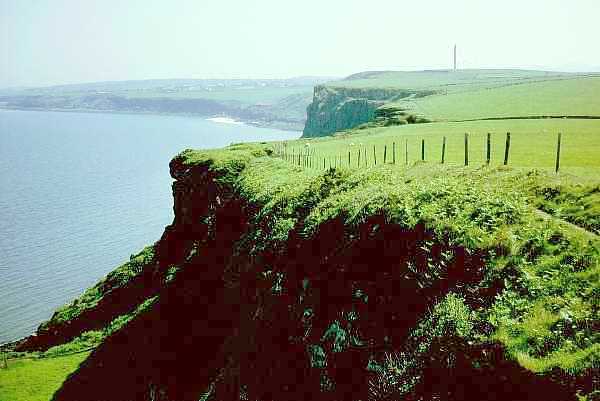
I started out from the B&B at 8.45 arriving at the starting point at 9.00 where I met the first group of 5 Coast to Coast walkers consisting of one couple and two female friends who were doing the whole walk, plus a boyfriend who was only doing the first few days. They all appeared to be in their twenties and were a little less friendly than most walkers, later earning them the nickname of `The Yuppies'. Dipping the boots in the sea is the customary start to the walk, so I duly walked out to the sea at low tide - the walk from the B&B and to the sea and back added about a mile and a half to the 19 mile walk.
Start at St Bees Head
Fleswick Bay
Saltom Bay and Whitehaven
The day was beautifully sunny and, as I made way along the first few miles of pleasant cliff scenery, I started to meet several other groups of Coast to Coast walkers. The initial walk along the coast is followed by a less interesting walk heading inland, passing by a few industrial areas. I stopped for lunch just before Cleator and then, as it was very hot, called for a pint of nondescript, pressurised beer in a dump of a pub on the main road in Cleator. The only place to drink the beer was standing on the narrow pavement by the busy main road next to a rowdy group of youths - I didn't stay long.
After the coast, the first place of any merit is Dent hill which, after a steady climb, reveals good views of the Lake District mountains and back towards the coast. The weather started to cloud over a little, but was still very warm - I had been walking most of the way without my T shirt. I met up with a group of three who were in the process of revising Wainwright's guide book with recent changes to footpaths. There have been some off-road routes negotiated near Orton and some route changes to avoid erosion near Nine Standards Rigg.
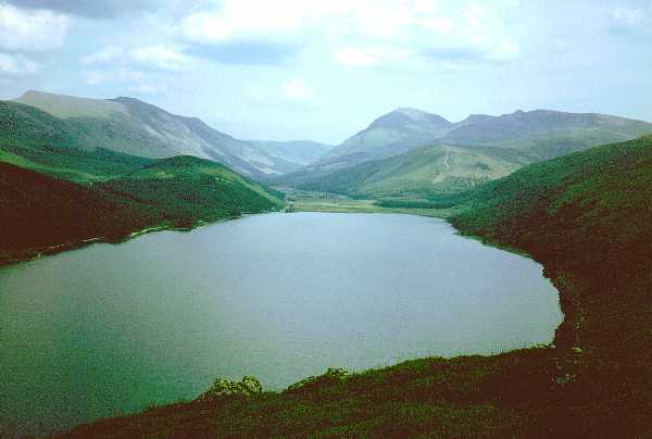
Ennerdale Water
From Dent the route drops down to the very pleasant valley of Nannycatch before joining the long road walk to Ennerdale Water, where there were diversions to the route due to work on the dam. I climbed up over Angler's Crag, partly by mistake, but it was well worth it for the view of the lake. By this time my feet were starting to get sore with one or two blisters starting, possibly contributed to by the hot weather and the hard surfaces under foot. My shoulders were also a bit painful from carrying the rucksack, but were greatly helped by the fact that the waistband on this new rucksack took quite a lot of the weight away from my shoulders. After attending to the blisters, I set off again at 5pm. with two and a half miles to go along the very stony path by the lake and along the forest road to the Youth Hostel, where I arrived at 6.20pm. There were a few other groups of walkers including a group of three Londoners from a running club. They were great characters and nicknamed themselves GBH (Graham, Brian and Henry). They were following a very similar schedule to mine, so I was to see quite a lot of them during the rest of the walk. The `Yuppies' did not arrive until half way through the evening meal and seemed to expect waiter service from everyone else, rather than doing their bit. The three girls never seemed to smile and I was not sure whether it was because they were finding the walk an ordeal, or whether they were always like that. As several people had ordered vegetarian meals, dinner was curry soup, vegetarian goulash and treacle sponge.
It was a beautiful evening but, being in the forest, we were plagued by midges so, after a while I returned indoors. The hostel, being so remote, has no electricity so the lighting was from mantles supplied by bottled gas. I didn't get a very good night's sleep as it was so hot with the hostel heating still on despite the hot weather.
Day 2 - Monday 8th June 1992 - Ennerdale to Longthwaite via High Stile
Distance: 10 miles + 4 miles off route to Great Gable
Accommodation - YHA Longthwaite - �14.05 with full meals and packed lunch
I woke up to a beautiful morning but by the time breakfast was over it had started to cloud over. I started out at 9.20 and set off up the steep climb to the high level alternative route via Red Pike which I reached with a lot of sweat at 10.25. The clouds had thickened quite a lot but were just high enough to allow glimpses through the haze and patches of cloud, of the fabulous views over Crummock water and Buttermere, as I progressed along the ridge of mountains. A few heavy showers came along and the weather over the mountains to the south looked decidedly dubious, but there were a few brighter spells in between, so I decided to climb Great Gable, which is about 2 miles off route. Its summit was in and out of the cloud, so I was not sure what weather to expect when I got there. To save effort, as I would have to retrace my steps, I left my rucksack neatly propped against a large rock and set off, taking only my waterproofs, camera and wallet with me. Over Green Gable the mist descended and I took the wrong route over the very steep edge of Green Gable thinking that I was dropping down to Windy Gap but then saw, as the mist lifted, that I had dropped a few hundred feet below the ridge and had to scramble back up again to resume my ascent of Great Gable. At 3.10 I reached the summit which was covered in mist which almost lifted but not quite enough to provide a view. Twenty years and a couple of weeks ago I proposed to Jean on this spot - It was the first and probably the last time she would ever climb a mountain!
Red Pike from High Stile
Buttermere from High Crag
Jean on Great Gable 20 Years Earlier
Returning back via Green Gable the cloud lifted a bit more and, by the time I had returned to where I had left my rucksack, it had lifted right off Great Gable so it was a pity that I hadn't enough spare time to have stayed at the summit longer. I found the rock where I had left my pack an hour or so before only to find that it was no longer there. I scouted around the area in case I had mistaken the spot, but that was the only place it could have been. Thinking that it must have been stolen, I looked around to see if any of the contents had been dumped but saw nothing. The only option left was to make my way to the Youth Hostel and start phoning from there. In the meantime my head was spinning trying to work out what I could do to get emergency replacements of things to allow me to continue the walk.
Seatoller and Borrowdale
Just as I was approaching Longthwaite Youth Hostel I noticed a few walkers eyeing me oddly and then one couple asked if I were the one who owned a blue rucksack. They had met up with another couple at Honister and the other couple had found my rucksack, thought that I may have been in difficulty somewhere, so started to call my name, which they had found from my YHA card. On getting no reply they decided that the best thing to do was to take the rucksack to Honister Youth Hostel, but the warden knew nothing about me, as I wasn't booked in there. When I entered Longthwaite Youth Hostel I found that the warden there had already found out about my plight. However, on making further enquiries it ensued that the couple had insisted on taking the rucksack to Keswick police station. By this time it was too late to catch the last bus to Keswick. The warden rang the police for me and they said that they had nobody free at the time but would see if they could drop it off later in the evening. It was delivered, much to my relief, by a police van at 8.30pm.
The only positive point to the whole escapade was that the walk down to the hostel was much easier without anything to carry, although I would have been more than happy to forego this to avoid all the anxiety that I went through. News of this incident quickly spread through the grapevine to most of the other Coast to Coast walkers and I soon became a celebrity, with people pointing me out from afar!
Dinner in the hostel, which I had to have unwashed and unchanged, was soup, sausage casserole and scone in the company of over eighty schoolchildren. They were quite well behaved but the dining room was very cramped making serving of the food very difficult and the volume of noise in such confined conditions was bound to be excessive. Fortunately my dormitory was a small one and not the one containing any of the children, so there was at least the prospect of a reasonable night's sleep.
The earlier part of the evening brought torrential rain with heavy thunder but this gradually cleared up making a walk to the pub in Rosthwaite feasible. This valley has the dubious honour of having the highest rainfall in England at 150 inches a year. In the pub the Theakstons bitter was a bit off. I met up with Graham, Brian and Henry in there, drank with them and later walked back with them, arriving back at the hostel just before they locked up for the night.
Day 3 - Tuesday 9th June 1992 - Longthwaite to Grasmere
Distance: 9.5 miles + 1 mile detour to High Raise
Accommodation - YHA, Thorney Howe - �14.55 with full meals and packed lunch
Had a rather hectic breakfast at 8am with all the children, and set off in fine but humid and hazy weather. There was a pleasant walk along the Stonethwaite valley, then a steady climb getting steeper up to Lining Crag with good views and waterfalls along the way. By 12am I had reached Greenup Edge, so decided to go off route to High Raise which gave some fine views of the western mountains. This time, when I left the rucksack, I left a big note on it saying "Gone to Summit - Returning Shortly" to avoid a repetition of yesterday's fiasco.
Eel Crags from Longthwaite
Stonethwaite Beck
Grasmere from Helm Crag
After lunch back at Greenup Edge, I set off along the crags feeling rather weary. At first I thought that I might be dehydrated so I drank a litre of water from a mountain stream - one advantage of the Lake District is that there are plenty of streams and sometimes they have the bonus of a dead sheep in them for added protein! After the drink I felt worse so I was glad that I had plenty of time to amble along and stop for rests as and when I felt like it. The problem turned out to be just a bit of a stomach upset which passed away by the next day. The walk along the crags towards Grasmere gave some good views of Helvellyn, Fairfield etc. and then overlooked Grasmere lake. The last bit of the walk was accompanied by rumbles of thunder, but I reached the hostel in good time before the heavy downpour that followed.
The hostel was quite small and cosy compared to the previous one - there was also another, larger hostel closer to Grasmere. Although the evening meal was quite basic, consisting of soup, Cumberland sausage with roast potatoes and green beans, and apple crumble, it was cooked to perfection and far better than in most hostels. The previous day's thunderstorm had brought water flooding in through the hostel door and into the dormitory in which I was sleeping. The carpet was still soaking wet, so it was a nuisance trying to find a dry place when putting anything on the floor. It also meant getting wet feet when getting in and out of bed, and having to put up with a stagnant water smell all night from the carpet.
I walked into Grasmere village after dinner midst threatening rumblings of thunder, but there were only a few small showers. After walking down to Wordsworth's cottage and museum complex, I returned to the village and happened upon the pub where Graham, Brian and Henry and some others were having a drink. A Dutch chap who was doing the Coast to Coast in the opposite direction and who was in the same hostel as me (the others were in the big hostel), came in shortly afterwards and joined us, so I walked back to the hostel with him later.
Day 4 - Wednesday 10th June 1992 - Grasmere to Patterdale via Helvellyn
Distance: 10 miles
Accommodation - YHA, Patterdale �15.25 with full meals and packed lunch
The weariness from the previous day's stomach upset had now gone and the blisters on my feet, after some doctoring, were starting to improve. The only problem with blisters is actually getting started again after each stop. After hobbling along for about half a mile or so the pain goes away and then they are hardly noticeable until the next stop. It pays to prick the ones which have puffed up otherwise they just spread outwards but, apart from that, they seem to stop hurting after about three days as the skin underneath ceases to be tender.
I set off at 9.30am with the weather rather overcast and spotting with rain, but with the cloud level above the mountain tops, which were reasonably clear. There was a steady climb, quite steep in places, up by Great Tongue to Grisedale Tarn. This was followed by a steep climb up Dollywagon Pike to follow the high level alternative route over Helvellyn, otherwise the main route runs steadily down the valley to Patterdale. There was a very cold wind at the top of Helvellyn and I put on my pullover and waterproofs to keep warm. After lunch near the summit the weather gradually started to improve and the wind dropped considerably. Helvellyn is very central to the Lake District and nearly every major peak can be seen from the summit as well as sections of the Pennines.
Swirral Edge & Catstye Cam
Striding Edge from Helvellyn
Ullswater and Place Fell
As I started my descent to Striding Edge, after spending some time around the summit, I saw a large group of people sporting pin stripe suits, ties, bowler hats and rolled up umbrellas coming the other way. It turns out that they were from Austin Reed and were involved in a charity Telethon. As the afternoon progressed the weather gradually improved ending in beautiful sunshine giving marvellous views down onto Glenridding and Ullswater as well as views of the route of the next day's walk up towards High Street. Further north it was just possible to make out the 'golf ball' of the radar station on Great Dun Fell. I stopped several times to sit and admire the view as there was plenty of time to spare.
On the road through Patterdale towards the Youth Hostel I passed the hotel where Graham, Brian and Henry were having a drink on the lawn outside in the warm sunshine, so I stopped for a pint of very good Marston's with them before booking in to the hostel. The hostel is a very large one and had another big school party staying. However, because the dining room was large and had an extra extension to it, the school party were not any problem at all. Dinner was soup, chicken casserole and rice pudding.
It was a very fine evening, so I went for a stroll to the end of Ullswater and into Glenridding before calling back into the hotel for a pint. The others had said they would be going there but it ensued that they had gone to the other pub in Patterdale. I went back to the hostel and was just about asleep when I heard a lot of crashing about, which turned out to be Brian and Henry climbing in through the dormitory window having returned after the hostel door had been locked.
Day 5 - Thursday 11th June 1992 - Patterdale to Shap
Distance: 16 miles + 2 miles to High Street summit
Accommodation - New Ing Farm B&B, Shap �13.50
The day started off fine and clear with a pleasant breeze, although a few clouds appeared before lunch time but cleared away in the afternoon. The blisters on my feet were getting better - the big blister on my right heel from the first day was virtually healed and the smaller ones from the second day were greatly improved. After a few days of walking the balls of my feet were beginning to ache, but they were worse than that before I even set off on the Pennine Way.
Brother's Water & Kirkstone Pass
Angle Tarn
Blea Tarn & Harter Fell
There were some very good views of Brother's Water on the way up to Angle Tarn, and more fine views from the Straits of Riggindale looking over towards Hawes Water. I decided to take a walk to the summit of High Street as the weather was so fine, so left the rucksack with note attached whilst making the detour. The extra walk was well worthwhile as it gave a lovely bird's eye view of Blea Tarn and Riggindale from one side and Hayes Water from the other. After lunch at 1pm on Kidsty Pike I set off again at 1.30pm. The packed lunch from some hostels leaves a lot to be desired - this one consisted of 1 cheese roll, 1 packet of crisps, 1 United bar and 1 apple - not very good value for �1.90.
Hayes Water from High Street
Hawes Water from Riggindale
Ruins of Shap Abbey
The walk down to Hawes water was fairly steep and the route along the lake was fairly pleasant to start with, but became rather a long drag after a while. At the end of the lake was a house with a lady doing a roaring trade selling mugs of tea to walkers. The route then followed streams and went across meadows to eventually arrive at Shap Abbey and from there along the road to Shap, where my B&B was right at the entrance to the village. At Shap Abbey I caught up with a young couple who I had met several times before. The chap was limping, having had a problem with his knee. Fortunately, though, he managed to continue and complete the walk with a bandage without having too much trouble.
Market Cross, Shap
The lady at the B&B gave me a very welcome pint glass of cool orange drink when I arrived, as it was so hot. Having showered and changed, I set off down the village in search of a meal. There was a fish and chip cafe and inside were Graham, Brian and Henry, so I joined them and had fish, chips, peas, tea, bread and butter with ice cream to follow for �3.65. Later I went down to the pub where a large number of Coast to Coast walkers were gathered.
Day 6 - Friday 12th June 1992 - Shap to Kirkby Stephen
Distance: 22 miles
Accommodation - YHA, Kirkby Stephen - �12.10 with meals (no packed lunch)
I had breakfast at 8am. There were no other walkers at the B&B, only a couple of chaps on their way to Scotland. After calling at the shops to buy things for lunch I set off at 9.10am. It was very easy and pleasant walking country with beautiful weather. There were not a lot of features to the landscape but there were views of the Pennines to the east (Cross Fell, Great Dun Fell etc.) and the Howgill Fells to the south. Much of the walk was over a velvet carpet of grass which was very easy on the feet. With 22 miles to walk it was necessary to press on at a reasonable rate, so the first stop was after 5.5 miles at 11.15 with a quarter of the distance done. After a snack and half hour rest I set off again towards Orton. I managed to find the first bit of off-road alternative leading down through meadows with masses of wild flowers and then following a stream into the village. I only wish I could identify some of the flowers - there seem to be a greater variety than around home, possibly because the meadows have not been treated with herbicides for some years.
After Orton came a long stretch of road walking. This part of the route was hastily put in as an amendment to Wainwright's original route because the path over Orton Scar was not a right of way. A couple of footpaths have recently been defined and avoid much of the road walking, but I didn't see these until I had passed the points where I could easily join either of them, so ended up walking along the road. At least the road was quiet and there were pleasant verges, with a host of wild flowers to look at, but it was still a bit tedious. I stopped for half an hour for lunch and a 'boots off' rest at 1.30pm just past the day's half way point and sunbathed. There was not a cloud in the sky and it was starting to get quite hot.
After another 1.5 miles of road walking I reached Sunbiggin Tarn which was threshing with wild fowl all making a heck of a din. The area around there is also noted for rare plants and there were ladies searching for a particularly rare species of fern which had been sighted nearby. The route then, at least, was off the road and pleasant, but became a bit of a drag with so many miles to go and not many interesting features to break up the walk. I stopped again at the three quarter way point at 3.45pm and aired off my feet again. By this time the full heat of the day had built up so I even resorted to resting in the shade. I had a drink of hot orange from the flask that had been on the sunny side of my rucksack and a drink of warm orange from the flask on the other side. As for my chocolate biscuits, they were just a molten sticky mess. I set off again at 4pm and the scenery soon became much more interesting as I entered Smardale with its pack horse bridge, old lime kilns, ancient settlements and railway viaduct. I arrived in Kirkby Stephen at 6pm and went into church for the night! - the Youth Hostel there is a converted church, there being something of an excess of churches in the town. The evening meal was good with 4 choices of main course - I had soup, cornish pasty and rhubarb pie with ice cream.
Smardale Bridge
Smardale Gill
Graham, Brian and Henry had been shopping around town and two of them had bought ex East German army shirts for �1 each. Graham soon started to realise that, much as it may have been a bargain, it was also extra weight to carry for over 100 miles, so he started trying to sell it again for 50 pence. When this didn't work he ended up by giving it away to a New Zealander in the hostel. Brian, however, carried his all the way to Robin Hood's Bay without once wearing it. The irony of this being that the three of them were returning to Kirkby Stephen at the end of the walk to catch their train back to London, having used the Coast to Coast transport service to get them from there to the start, and back from the finish. The three of them were always joking about having got all the "High Tech, Super Lightweight, Carbon Fibre......." gear to cut down on weight, with Brian saying that he had been so paranoid about weight that if a fly landed on the rucksack he had to brush it off straight away, so this made the situation even more amusing. In shopping for his equipment beforehand, Brian, who had recently been made redundant, bought a waterproof jacket for �180 and made the mistake of leaving the receipt around for his wife to find. Not surprisingly, she was not amused. It rained very little on the walk so they reckoned that it had cost about �10 a minute for the use he got out of it.
Later in the evening I met Graham, Brian and Henry again, plus others, in one of the many pubs in town. Graham kept telling the tale of his wife having given up after 40 miles of the 46 miles of the Peddars' Way because she got a blister, and in some of the banter about Northerners vs Southerners, Brian remarked "I suppose that, if you Northerners get blisters, you just sew some pieces of Brillo pads into your socks!".
Day 7 - Saturday 13th June 1992 - Kirkby Stephen to Keld - via Nine Standards Rigg
Distance: 12.5 miles
Accommodation - YHA Keld - �13.65 with full meals and packed lunch
Market Square, Kirkby Stephen
Nine Standards Rigg
Waterfall near Raven Seat
Started off the walk at 9.45am on what looked like another scorching hot day, although there was, at least, a bit of a breeze on higher ground. I met up with a group of about 10 policemen who were walking the Coast to Coast, but they were not as friendly as most other people. Some of them seemed to be struggling a bit in the heat despite the fact that they were not carrying packs, but had had their gear sent ahead. There was a steady climb up to the summit of Nine Standards Rigg at 2171 ft above sea level, which I reached at 11.45am. There was a large crowd at the summit and I spent about an hour there, as there was not a lot of distance to walk that day and the weather was very pleasant. The view was slightly hazy, but Great Dun Fell, Great Shunner Fell, Tan Hill Inn, Sleightholme Moor, Bowes Moor etc. on the Pennine Way could be clearly seen, although it was not quite possible to see back to the Lakeland Fells. Again, because I had plenty of time, I spent about an hour on the descent sunbathing. I had to put my T shirt back on, though, because my shoulders were starting to get a bit sore where the rucksack straps were rubbing against the sunburn. The scenery was a complete contrast to the steep and rugged crags of the Lake District with miles and miles of open moorland. There were a number of picturesque little valleys with streams and waterfalls to break up the monotony of the moorland scenery, however.
After a leisurely walk with more stops in the sunshine, I arrived at Keld Youth Hostel at 5.10pm I was glad to see that the rather creaking bunk beds of the previous year had been replaced or repaired. What seems to have happened in most hostels is that the old bed springs and wire supports underneath the mattresses, half of which tended to be broken, have been replaced by wooden boards. This avoids all the sagging and creaking, but leaves only the fairly thin mattress to provide any degree of softness. Still, you can't win them all!
It appears that the group of policemen, who had been intending to walk right on to Reeth, had found the going and the heat too much for them and dropped out at Keld. They had sent all their packs ahead to Reeth, so had to phone up a friend with a minibus to collect them. So much for the calibre of the modern police officer! They had also been seen earlier by some of the others outside a cafe, where some of the younger ones were kicking a football about and generally making a nuisance of themselves until they were told off by their sergeant.
Keld is the crossing point of the Pennine Way and the Coast to Coast walk and roughly the halfway point of each, so it seemed strange that there were no Pennine Way walkers in the hostel that evening. Brian, being confronted with a potential disaster situation of having no pub in the village, was busily trying to eye up anyone who might provide a lift to the nearest pub, 3 miles away in Muker. He met with no success, so he, Henry and I decided to walk there immediately after dinner. An American young lady staying at the hostel was totally incredulous that we were prepared to walk over six miles just to get a drink! However, neither the present day's walk nor the next day's were very long, and it was a pleasant midsummer evening with daylight lasting until well after 10pm. Also, the route to the pub was along a valley of outstanding natural beauty, so it was well worthwhile doing apart from the prospect of a few well-earned pints of beer.
Dinner was soup, cottage pie and sponge pudding and was finished in fairly good time so we were able to set off for Muker at about 7.45. I took them along the Pennine Way route, which gives a fine view across upper Swaledale, but which runs fairly high up the side of the valley and was rather rocky under foot and, therefore, not a good route for the return journey in the fading light of day. They both swore that they wanted nothing to do with the Pennine Way after that. We reached the pub in just one hour, so set off back at 10pm having been advised to take the better footpath on the other side of the valley. This meant first finding the footbridge across the river Swale and, as our first attempt was along the wrong route, we wasted about 10 minutes retracing our steps. Having then found the right path and walked at a very brisk pace we arrived back at 11.15pm as the route, though easier, was about half a mile longer. The last traces of twilight had all but disappeared by the time we got back and we had to resort to torchlight for the last part of the way. Brian had been told that warden wouldn't lock up until 11.30pm, but the door was already locked when we arrived (the official locking-up time being 11pm). However, the warden let us in with a rebuke so we did not have to bring into action the contingency plan of using the fire escape to the second floor.
Day 8 - Sunday 14th June 1992 - Keld to Grinton
Distance: 12.5 miles
Accommodation - YHA Grinton Lodge �13.65 including full meals and packed lunch
Old Gang Smelt Mill
Set off at 9.15 with the weather rather overcast and with a cool wind, which made a pleasant change from the heat of the past few days. The route goes past the ruins of many of the old lead mines and smelt mills in the area. In parts the landscape has been completely devastated with spoil heaps and there are still large areas completely devoid of vegetation after all these years. This is because of the poisonous effects of the lead on the flora, which prevents nature from covering up some of the scars on the landscape, though it does give an interesting insight into the industrial history of the region. One can imagine what the working conditions must have been like high up on the moors in the middle of winter, matched only by those underground. Some of the mills are now being preserved, not before time, as part of our national heritage.
After the old mining areas, the route leads back to a track on the hillside overlooking the river Swale with good views along the dale. Some people took the alternative route, which omits the mines and follows the banks of the Swale down to Reeth. This is undoubtedly easier and, probably more picturesque, but it would have been a pity to miss out this part of the walk. For all of the ugliness of the scars on the landscape, there is also a beauty in some of the ruins of the mills in these steep moorland valleys.
Reeth was very busy with Sunday tourists, so I made my way straight up to the Youth Hostel. Grinton Lodge is about three quarters of a mile off route, up a steep road out of Grinton, and is built in the style of an old fort, commanding fine views over the Swale. I was a bit early and the hostel hadn't opened so I waited outside where I soon met up with Graham, Brian and Henry who were just coming up the hill. There was a school party in the hostel, so the male and female accommodation had been swapped around to allow them to be better catered for. I had dinner of soup, quiche and apple pie and later joined the others in the pub in Grinton, this time managing to get back to the hostel before closing time.
Day 9 - Monday 15th June 1992 - Grinton to Bolton-on-Swale
Distance: 18 miles - 1200 ft ascent
Accommodation - Bunk House, Leylands Farm - B&B �10 without dinner or lunch
Started out at 9.45am with the weather overcast with low cloud but, as there was no high level walking to do, the low cloud didn't matter so much. My shoulder started giving a bit of pain, having not given much trouble for quite a while, so I stopped for a few rests to help it along and it improved again after a few miles. The walk was pleasant, though not spectacular, through undulating countryside, with the walking easy and the temperature pleasantly cool. The tranquillity of Whitcliffe wood and the nearby hillside was disturbed by the pipe laying operations of Yorkshire Water and I was glad to get away from the tractors and other heavy vehicles which were busy in the area.
Richmond soon came into sight over the hill and the weather started to brighten up. At 1.45pm, I was just in time to catch a fish and chip shop before it closed, as my plan was to have a hot lunch, saving my packed lunch to eat later on in the evening. After a wander around the castle walls, I called at the bank to replenish my supply of cash, called for a pint of Bass, and called at the shops to get a few things for the next day's lunch. Not having a meal booked at the B&B I took my time and went down to the river where I cooled off my feet for a while before setting out on the rest of the walk at 3.30pm. It was well worthwhile spending some time in Richmond as it is a very historic town with its castle overlooking the river and its many interesting old buildings.
Richmond Bridge from Castle
Field of Poppies, Bolton-on-Swale
The terrain beyond Richmond was now much flatter although the walking was easy and pleasant, through farmland, more or less following the river. The route in these parts is extremely well signposted, so there is no difficulty finding the way. One particular bit through the woods was extremely muddy despite there having been little or no rain for ages and everywhere else being bone dry. At 7pm I reached the B&B, which had quite a few people staying there. Some were in bed and breakfast accommodation inside the farmhouse, some like myself in bunkhouse accommodation in outbuildings, and some were camping on the lawn, which led down to a duck pond in a lovely setting, surrounded by flowers and trees.
My feet were aching quite a bit when I arrived. This seems to happen for about an hour or so after stopping when all the nerves come back to life again. On the Pennine Way the aching often lasted all evening and sometimes through the night, but my feet must have been getting more used to the walking as it did not tend to last so long on this walk.
There is no pub in Bolton-on-Swale, so some of the others had persuaded the farmer to give them a lift into Scorton where there are three pubs. Against my better judgement, as it goes against the general principle of a walking holiday, I was persuaded to go along with them, as there was a seat going spare (the farmer was doing a double run).
Day 10 - Tuesday 16th June 1992 - Bolton-on-Swale to Osmotherley
Distance: 17 miles - 925 ft ascent
Accommodation - YHA Osmotherley �14.05 including full meals and packed lunch
Started out at 9am after breakfast at 8am to tackle the longest continuous road section of the walk (about 8 miles). At least the roads were very quiet country lanes with very few cars, and there were wide verges and hedgerows abounding in wild flowers to break the monotony. There is no real alternative to road walking in this sort of country, as any rights of way through fields have usually been ploughed up and are growing crops three feet high. The weather was good for walking, being fairly cool, but the general feeling about this day's walk was that it was just a matter of getting it over with to reach the more interesting scenery of the North Yorkshire Moors. The hills could be seen in the distance from time to time and very, very gradually began to look nearer.
My first stop was at 10.50 at Danby Wiske, which has a pub by the village green. It was a bit early in the day for drinking, so I had a rest and elevenses on a seat by the village green. 10 minutes later Graham, Brian and Henry arrived and headed straight into the pub. At 11.10 I set off again to stop next at the 10 mile point of the day at 12.30. Here the Cleveland Hills looked distinctly nearer, although still about 5 miles distant, and the road walking had given way largely to farm roads and paths. I met up with Graham, Brian and Henry again and made some comment about whether they were headed for the pub before closing time. Brian was not aware of the Blue Bell Inn 4 miles further on, at Ingleby Cross so his ears pricked up. A little while later I saw him marching off at a cracking pace whilst the others were having a rest. It seems that the mention of beer was too much for him to resist.
Towards Cleveland Hills
Blue Bell Inn, Ingleby Cross
As I reached Ingleby Cross, I stopped to take a photograph and suddenly saw Brian in the viewfinder, waving from the door of the Blue Bell. He was doing his bit, keeping the bar open and waiting for the other two to arrive. I joined him for a pint of Magnet and left him still waiting for the others who came along shortly afterwards. I made my way up the hill through the forest and then about a mile off route to Osmotherley Youth Hostel, arriving at 4.15pm. Three other lads, who were doing the Cleveland Way, came along and sat waiting for the hostel to open. My feet did not ache as much this time even though I had walked a similar distance to that on the previous day.
There was a party of young schoolchildren in the hostel and dinner was planned accordingly with no choice and only fruit juice as a starter, a child sized plate of chicken with about a dozen chips and a few vegetables, and fruit and ice cream for desert. We did manage to get a few extra chips and vegetables for seconds, but not many. The warden was miserable and unfriendly and some of the other walkers were complaining about the way he treated them. The teachers with the school party said that he had given them no co-operation at all and they would be glad when they left.
Henry was suffering from a problem with his thigh muscle, which had swollen up, and was very painful. He resorted to a trick, which he had used as a runner, and bought a pack of frozen peas to strap round his leg as an ice pack. He got the peas re-frozen each night and it kept his leg cool for about half of the next day.
I met up with many of the walkers again later in a pub in Osmotherley. Some of them went to buy fish and chips to supplement the skimpy meal in the hostel.
We heard later, that a woman in her 50s from Luton, who was walking with her husband and her boss, had a slight mishap at Ingleby Cross. They had stayed the previous night in Richmond, so it had been a long day's walk of 23 miles to Ingleby Cross, with the weather getting quite hot in the afternoon. The woman sat in the bar after the walk, had a drink and then passed out and fell off the stool. Fortunately, there was no lasting harm done, and she was alright afterwards.
Day 11 - Wednesday 17th June 1992 - Osmotherley to Farndale
Distance: 18 miles + 2 miles from/to accommodation - 3340 ft ascent + 170 ft from YHA
Accommodation - B&B Head House Farm, Farndale �10 + �1.50 packed lunch
Breakfast at the Youth Hostel was not bad, as we were able to get extra toast and tea, partly by having them provided and partly by taking the left-overs from the children's tables. I set off at 9.05am on what was probably the toughest day of the whole walk with 20 miles and a lot of climbing, the route going up and down over several moors before levelling out along the track of the old railway. It was a glorious day for walking the wide, open moors with fine views all around, restricted only by a little distant haze. The path was wide and easy, initially being part of the Lyke Wake Walk and the Cleveland Way as well as the Coast to Coast walk, and lent itself to good walking speeds whilst still enabling the views to be appreciated.
Cold Moor
Hasty Bank from Cold Moor
Wain Stones on Hasty Bank
After about 6 miles I stopped for a break at 11am. The beauty of the scenery around here is not so much in the hills themselves, as in the fact that you walk along the edges of them with a bird's eye view of the plains below. I stopped again at the half-way point of the day for lunch in the warm sun on Cold Moor at 1.10pm and then laid down sunbathing having done the hardest part of the walk involving 5 of the 7 climbs. Graham, Brian and Henry came along and stopped for a while at 2pm and I eventually set off again at 2.20. I had mentioned to them that I had met up with the two 'Australians' on the way, which puzzled them. When I had described them they then informed me that they were not Australians, but came from Newmarket. I said that I could identify most accents from around the U.K. and that they definitely sounded Australian. This caused great amusement later when they told the two of them, and I got ribbed about it later. After the last two climbs it was easy to maintain a good walking speed and I reached the old railway at 4.15pm, where I had another rest in the scorching heat. Graham, Brian and Henry came along again and, as they had booked into the same B&B as me, I walked the rest of the way with them. The route along the railway is not very interesting, but is very easy for walking and fairly kind on the feet.
The path down to the farm was rather awkward, as it is not used much with signs saying "No footpath". However, as we were going to the farm, we thought it would be alright to ignore these. We arrived at the farm, which was a smallholding of 20 acres run by an elderly couple, at about 6.30pm and had a cup of tea. We tossed coins for who should go first in the bath, on the assumption that the hot water would not last very long. Graham went first and hit the first problem - the cold water came at a trickle whilst the hot water gushed out until the header tank emptied. He had a bath full of scalding hot water and had to run half of it away so it didn't take too long to cool down with cold water. Brian went next and found that both hot and cold were running at a trickle so, after a long delay, he managed only a couple of inches of water. Henry then decided to use the same water, rather than wait even longer, but then ran it off because it was getting very dirty. Finally I went in and managed, very slowly, to get a few inches of water. This is one of the disadvantages of a bath rather than a shower when there are a few people who want to use it.
We went down to the pub in Church Houses for a meal where I had Cumberland sausage for �3.50. The portions were very large and Graham could not eat all of his Pizza, so I finished off that for him as well, to make up for the previous night's poor dinner. I had already earned the reputation of being a human dustbin, as I had eaten 3 sausages that Graham didn't want for breakfast on a previous occasion, but despite all this I still lost a few pounds in weight on the walk. I tried to telephone home from the village phone box, but it was out of order.
Day 12 - Thursday 18th June 1992 - Farndale to Grosmont
Distance: 14.7 miles on C2C + 0.8 miles from B&B - 870 ft ascent on C2C + 650 ft from B&B
Accommodation - B&B, Fairhead Farm, Grosmont �15 including evening meal
After a huge breakfast we set off at about 10am into a very cool northerly wind with overcast skies and the odd shower of rain. The wind was even stronger once we got back onto the top of the moors. Brian looked longingly at the Lion Inn, Blakey, but it was only 10.45 with not much sign of life in there, so he resisted the temptation to go in. At Trough House, a refuge shelter, I stopped for lunch and a welcome respite from the wind whilst the others headed on to Glaisdale for a pub meal. In contrast to the YHA packed lunches, the one I got from Head House Farm for �1.50 lasted me for two days.
Fat Betty
Steam Train, Grosmont
After dropping down from the moors into Glaisdale there was more shelter from the wind and the sky got brighter, although there was still the odd shower of rain. Having had a bar meal and found their B&B in Glaisdale, Graham, Brian and Henry took the train to Grosmont hoping to catch the steam train from there to Pickering, but they didn't manage it as they would not have been able to get a train back again.
There followed a pleasant walk along a wooded valley towards Egton Bridge. On the way from Egton Bridge to Grosmont I met up with a couple in their 50s who I had met up with several times previously. They had been mainly camping along the way and had been sending part of their equipment on using the "Pack Horse" service, although they had managed to get their pack weights down to only a stone each, which is less than most Youth Hostellers managed. The wife had hurt her foot and was limping along badly, although she managed to struggle on bravely to the end of the walk.
At Grosmont there was a steam train waiting at the Station, so I had a look at that and waited for it to set off. The B&B involved a climb of about 500 ft up the hill on the way out of Grosmont, so I was debating whether I should wait until 6pm and ring home from Grosmont but possibly be a little late arriving for dinner, or head straight there and walk back down later. As the weather was rather cool, I decided on the latter. However, I was spared the walk as Jean rang the B&B because she had to go out. There were very good views across the valley from the farm and the room and meals were good.
Day 13 - Friday 19th June 1992 - Grosmont (Fairhead Farm) to Robin Hood's Bay -
Distance: 15 miles - 1450 ft ascent
Accommodation - YHA Boggle Hole �12.60 with full meals but no packed lunch
The weather was rather cold and windy again but, after walking over the moor, there was a pleasant sheltered walk along Little Beck and May Beck. Through the woods there are a few interesting features such as the Hermitage, which is a dome shaped shelter hollowed out of a large solid boulder of rock, and Falling Foss waterfall. There followed another few miles of walk across the moors with no shelter from the wind. Whitby and the North Sea were in sight from many places along the route although somewhat masked by mist and haze. Eventually the path dropped down from the moors and there was enough shelter from the wind to stop for lunch. From there on it was not many miles to Northcliffe and the sea, where the waves were crashing in and spray coming over the cliffs in places.
Falling Foss
North Sea from Ness Point
Robin Hood's Bay
The last 3.5 miles of the walk along the cliffs, despite being buffeted by the wind, was pleasant as the rough sea gave more drama and majesty to the scenery. Eventually the final headland was rounded and Robin Hood's Bay came into sight and was reached at 4pm. The only thing left was the final ceremony of dipping the boots into the sea to complete the linking of the Irish Sea and the North Sea. I didn't bother to go into the Bay Hotel to sign the book or buy a certificate for �2, or buy a Coast to Coast T shirt.
Boggle Hole Youth Hostel is about a half-mile walk along the cliffs in a little hollow. It caters for large school parties and has an annexe as well as the main building. Most people had been unable to book in there, but the main dormitories were almost empty, the school party being in the annexe. I can only assume that they had another party booked in who then cancelled, although they may have had problems catering for many more in the dining room. Dinner was soup, fish fingers and spotted dick.
Later on I went back to Robin Hood's Bay to the Victoria Hotel where Graham, Brian and Henry had arranged to meet some of the others. As I entered the bar a great cheer went up from the host of Coast to Coast walkers in there, and it was a very lively evening until I had to leave to get back to the hostel before it closed.
All that remained the next morning was to find the route back home by public transport, which turned out to be easier than I expected. There was a bus from Robin Hood's Bay to Scarborough, arriving outside the station five minutes before the departure of the train to York and from there I caught the Doncaster bus dropping me off 2 miles from home in Norton. The total cost of the fares was about �11. I was all set to walk the rest of the way, but Jean had managed to get a neighbour to pick me up, so I was back home by 2pm.
Recovery After the Walk
After the Pennine Way the previous year it took me about 3 weeks to feel completely back to normal again. During that time I felt tired and weary and my feet ached from time to time. After this walk I seemed to be better within a few days, although it is hard to tell exactly because the following week brought some oppressively hot weather during which I felt washed out, but I would have probably felt the same even if I had not been on the walk. Certainly I did not suffer as much from sore feet this time as they took very little time to recover.
As for the question of whether training does good or harm, I do not regret having done none this time. The only thing which I would do differently, if I were to do another such walk, would be to make sure that I kept wearing boots for any walking I did beforehand to harden my feet more and, hopefully, reduce the problems I had with blisters. Even so I think that some of the problems were aggravated by the hot weather and possibly by my choice of socks. In terms of fitness for the walk, I still maintain that it is quite enough to keep fit by doing a good walk every two or three weeks and that there is no need for daily slogs carrying a full pack. Training seems to do nothing to help pain in the shoulders; in fact all that seems to happen on a long walk is that the affected area tends to go numb to most of the pain rather than building up any extra strength to support the weight. Certainly the investment in a rucksack with a waistband was well worthwhile, as was the attempt to keep weight to a minimum. On reflection, I could have reduced the weight even further by having less spare clothes, but this would have meant there was less flexibility as to when things had to be washed. The other thing to bear in mind is that different weather could have required extra clothing, particularly if everything got soaked, so it was wise to have a few things in reserve. Again, I never wore my gaiters throughout the entire walk and, even had it been wet, there were very few places where they would have been needed, so they could have been dispensed with.
Unlike the Pennine Way, there are not many sections of the Coast to Coast walk where it is not possible to buy food for lunches. In view of the rather poor packed lunches that the Youth Hostels provide, it would have been better not to have booked any in advance, as they could always be booked on the evening of arrival if it were found that no other facilities were available.
Coast to Coast versus Pennine Way
So - how does this walk compare with the Pennine Way?
They both have good points and bad points and some people would favour one or the other depending on their own walking preferences. Without the Lake District part of the Coast to Coast walk I think the Pennine Way would outshine it by far, but there is no finer scenery in the country, in my opinion, than the Lake District, so this redresses the balance between them. The Coast to Coast walk has, perhaps more picturesque scenery but has the disadvantage of having a lot of road walking, with about a quarter of the walk being on public roads. The Pennine Way, on the other hand, studiously avoids roads except for a few short stretches, but has a lot more rough walking over boggy moors, which does not appeal to some people. Many of the people walking the Coast to Coast were older and more used to gentler walking, taking the options of the easier routes where possible and making use of the "Pack Horse" service for sending ahead rucksacks. For them, the more difficult terrain of the Pennine Way would not be very suitable.
The Coast to Coast walk has gained far more popularity in recent years and one of the drawbacks is that there are so many people doing the walk. In this respect it would be preferable to set off mid-week as the bulk of people set off at the weekend. There would then be much more peace out over the hills and less problems booking accommodation.
Photography and Technology
Over the years that I have been doing long distance walks, camera technology, Internet technology and display technology have developed by giant leaps from 35mm colour slides that had to be scanned to produce low quality digital images for the website up to the present day with high quality digital photography, almost unlimited memory and super fast broadband,
The article in the 'Other Items' section chronacles all of this throughout my walks.