Offa's Dyke Path 2002

Author: George Tod
This walk is illustrated with photographs. Click on small photo to enlarge in situ, or click caption to enlarge into new window.
Offa's Dyke Path 2002 |
||
|
Author: George TodThis walk is illustrated with photographs. Click on small photo to enlarge in situ, or click caption to enlarge into new window. |
|
| Part 1 - Preparation and Sedbury to Monmouth | ||

[Index of Walks]
[Previous]
[Top]
[Next]
Offa's Dyke Path is a walk that I have often considered and rejected on the grounds that, looking at the map of the walk, it does not appear to be quite my type of walk. It does not follow a high level route for much of the way and there are considerable stretches crossing low level farm land and also following minor roads for more distance than I like. However, a number of walkers that I have spoken to regard it as an excellent walk and, as the end of the walk at Prestatyn is only about seven miles from my present home in St. Asaph, it seemed like a walk that just had to be done. In addition, it is always good to walk a path that you have not walked before, even if it does not quite compare with some other walks. In the case of Offa's Dyke Path, apart from having walked some parts of the path from Bodfari to Prestatyn and a few miles over the Black Mountains, all the rest of the path was virgin territory.
The path is a National Trail, opened in 1971, tracing the route of the ancient earthwork from which it takes its name. In places where no trace of the earthwork exist, either because none was constructed or because later urbanisation and farming activity have eradicated most of it, a suitable connecting or alternative route is taken to make the walk complete. The dyke is believed to have been constructed by Offa, king of Mercia in the 8th century, as a defence against the Welsh, and makes use, wherever possible, of natural defensive barriers such as hills and cliffs. These were made more secure by the addition of steep embankments and, where no natural barrier existed, a deep ditch and embankment were constructed to create one.
The route covered by two National Trail Guides published by the Ordnance Survey (ISBN 1-85410-671-6 Offa's Dyke Path South and ISBN 1-85410-771-2 Offa's Dyke Path North) as well as in other guide books. It is a pity that it could not have been combined into one book instead of being padded out with a host of circular walks around and about the trail and lots of other interesting information which is, nevertheless, not of prime importance as a guide to the walk. It would be far better to have a concise guide to the route with only essential information in just one compact volume to carry on the walk, and then a companion volume with wider range of historical and other associated information for background reading.
Although the route does not take in many high mountains, this does not mean that it is an easy walk. This area of the country is very undulating, which means that there are a lot of switchbacks along the way. For all the information that the guide books contain, they are distinctly lacking in information about how much ascent there is in each section of the walk. This is almost as important as the mileage when walkers are planning how much they should take on each day. It could be said that this can be seen from looking at the contours on the map sections, but these are deceptive in that some pages have contours at 5 metre intervals and some at 10 metre intervals, and then the last two sections suddenly switch to feet, just to confuse the issue. Considering that these are published by the Ordnance Survey, one would expect that this information could be easily calculated and included in the guides, saving individuals having to count feint and often obscured contour lines for themselves.
Having gone through the aforementioned tedious process, I worked out that the total ascent is about 30,000 ft, making an average of 2,500 ft per day on a 12 day walk. This is considerably more than the Pennine Way, which involves only about 1,800 ft a day on an 18 day walk. I have included in my diary the calculation of each day's ascent, but bear in mind that these may not be very accurate because of the difficulties involved.
[Index of Walks]
[Previous]
[Top]
[Next]
The walk is well covered by the two guide books, based on sections of 1:25,000 Ordnance Survey maps and I found, for the first time ever, that the sections laid out in the books fitted in quite nicely with the distances I like to cover each day, so I saw no need to modify them. Unlike many walks, Offa's Dyke Path goes through, or close by, several towns, particularly in the southern section, so accommodation is not as difficult to find as is often the case, and there are shops and pubs in many places along the way, with the exception of some of the more remote or high level sections of the path. The option of using Youth Hostels was ruled out, however, as there are now none that are on, or close to the route.
For accommodation, I found the web site of the Offa's Dyke Association to be excellent with up-to-date price information and other useful things such as the OS grid reference, distance from the nearest pub and distance from the route. The same information is published in a pocket-sized booklet for those who like to book as they go along. With the aid of this web site, I found little difficulty in booking all of my accommodation for the walk. The only place causing problems was the area around Chirk Mill, which is not far from Llangollen. I did not realise that I had planned the walk to pass through there right in the middle of the International Eisteddfod, when nearly all accommodation in the area was booked up months in advance. However, at Cloud Hill, the owners offered me a fold-up bed for the night, which seemed like the best offer I was likely to get, so I took them up on it.
I planned the walk to start on Tuesday 2nd July, as my brother was getting married on the previous Saturday, so this allowed me a couple of days to get myself organised after the wedding.
[Index of Walks]
[Previous]
[Top]
[Next]
I took the train from Rhyl to Chepstow changing at Birmingham and found to my surprise that, contrary to all the recent bad publicity about the rail network, the trains ran very well on time and I had a comfortable and easy journey down.
At Chepstow I had a wander around the town centre, round the outside of the castle and by the riverside before making my way towards a farmhouse to the north of Sedbury where I was staying for the night. I had planned on walking to the starting point of the path in the evening to save a bit of walking the next day, but the weather deteriorated badly with heavy rain forecast overnight and I just started to get caught up in this on the way to my B&B. After a heavy downpour, the rain eased off a little, allowing me to walk to the Cross Keys at Tutshill without getting too wet but it I didn't risk walking to the start point, deciding to leave that until the morning. I had some gammon and some very good Abbot Ale in the Cross Keys and, by the time I had finished, the rain had eased off again allowing me to return in only light drizzle.
[Index of Walks]
[Previous]
[Top]
[Next]
As forecast, there had been a lot of rain overnight but, by the morning, it had stopped although everywhere around had been given a good soaking and it was still quite dull and overcast. I started the day with a very good breakfast at 8 a.m. and met another couple of chaps from the London area, a father and son named Colin (I think) and Terry, who were also setting out to do the whole walk but with some different overnight stops from mine along the way. It was already starting to look like a more sociable walk than many I had done in recent years, where I had often met very few people walking the same path. The two of them had already walked to the start the previous day, so they could just take a short cut to the path missing out the first mile or more, whereas I had to walk over a mile to the start before embarking on the full 17.5 mile walk to Monmouth. Also, they were stopping at Redbrook for the night, a few miles before Monmouth, making a more sensible walk for the first day.
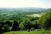
![]()
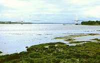 Severn Estuary and Bridge |
I called into Sedbury to buy a few things for lunch as well as a postcard to send home but neither the shop nor the Post Office nor the newsagent sold any postcards of the area at all. The way to the start was mainly along the road, then down a footpath running parallel to Offa's Dyke Path to the banks of the Severn Estuary with a fine view of the Severn Bridge. The official start is not on the estuary itself, but up some cliffs just above, so I made my way up there to the marker stone. The map shows a viewpoint from near there but I found that the view was almost completely screened off by the trees for as far as the path ran up the cliff. By the time I started off from the marker stone, it was already 9.40 a.m. and somewhat later than I had anticipated, so I set off at a good walking pace over the easy terrain.
Although the route on the map looks as if it should offer over the river Wye and Chepstow, it actually offers very little view at all and there are only brief glimpses of the river here and there. There are good views of housing estates, large houses, high walls, fences and trees but not much else to speak of. I accepted this around the urban areas, as it is often not easy to find a path with a view, but was disappointed when there were no open views most of the way along the cliffs above the River Wye. What I had to keep reminding myself, of course, was that this footpath does not set out to follow the most scenic route through the Welsh Borders, but it attempts to follow the route of a 1,200 year old earthwork built by King Offa to keep out the marauding Welshmen and not so that he could take a pleasant Sunday afternoon stroll admiring the view. The fact that good defensive positions often command a good view of the surrounding land is merely fortuitous but it is also possible that the tree covering could have increased since Offa's time as the amount of building definitely had.
![]()
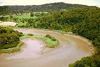 Bend in River Wye at Broadrock |
The road near Tutshill Lookout Tower offered a good view back across to the Severn Bridge in the distance and I also found a point near Broadrock where there was access to the cliff top with a rather spectacular view over a bend in the Wye, so I took the opportunity to stop there for a break and a snack. By now the grey skies had cleared and there was quite a lot of sunshine. Any illusion the Offa's Dyke Path was a well maintained path was quickly dispelled, as I had already had to fight my way through soaking undergrowth in several places. It may be alright in the dry, but the heavy downpour overnight weighed down any adjacent nettles, ferns and long grass so that they fell across the path and soaked my legs and shorts as well as giving me a few stings. Waymarking, however, is very good, although there are a few places where signs are missing or hidden by undergrowth, so it still needs some checking with the map from time to time when in doubt. As the general standard of waymarking is very good, though, it very quickly becomes apparent by the absence of waymarking, that you have strayed off the route and it doesn't take long to get back onto the path.
After negotiating a couple of road sections with no footpath, the path follows a ridge above the Wye Valley and extensive stretches of earthworks can be seen. It is an impressive feat of engineering and, to dyke enthusiasts, is probably one of the highlights of the walk. However, I have only a moderate interest in the historical aspects of the dyke and there is a limit to how much appreciation I can summon up for an embankment of earth and stones. The annoying thing from my perspective was that the whole section was covered in dense woodland so that there was virtually no view of the beautiful Wye Valley below. The most I managed to see were a few brief glimpses through the trees but these were few and far between. I had hoped to get a good view of Tintern Abbey like the one in the guidebook, but I can only assume that the chap who took it either climbed a tree or used a helicopter, as all I saw was a distant view partly obscured by trees.
To my great relief, I came out of the trees as I started to drop down to Brockweir, and made this gave a pleasant view of the village and the river. Colin and Terry were headed for the Brockweir Inn, which is just off the main Offa's Dyke Path along the Wye Valley Walk, an alternative riverside route which is a mile longer than the direct route over the St. Brevial's Common along the dyke. Having sampled the dyke route so far and seeing lots of trees over the hill, I decided to take the valley route and call in for a pint. Unfortunately, the other two had just left when I got there at 1.30 p.m. having arrived just before noon and stayed for lunch, so they must have been walking at a good speed.
![]()
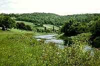 Wye Valley Walk |
It was so much nicer walking along the valley. I had the sun shining on me, a cool breeze in my face and a beautiful scene of green pastures, wild flowers and the river to look at - what a change from the gloomy tunnel through the trees earlier, and well worth the extra mile of extra walking.
After rejoining the main path a few miles further on, the route again went up through woodland. This time it was not so dense and there were shafts of sunlight filtering through, so it was not so gloomy, but it still blocked off the view. Even further along where the path emerged from the woods there was still not much of a view because of the woods lower down the hillside. Don't get me wrong: trees are things of great beauty but they are best appreciated either individually or in small clumps where they can spread their branches to full effect, enhancing the beauty of the countryside in the process. I am also quite happy walking through patches of ancient woodland for a while, but tire of them if they go on for too long. However, my main dislike of trees is when they cover the hilltops blocking out what would be a pleasant view. In this respect, high level walks are, in general, far better in that much of the land lies above the tree line and does not suffer the same problem.
On the way, I met an American couple who were headed for Redbrook. They were walking for seven days and just going as far as they could comfortably get in that time, which would be a little over half way. They were travelling light, as were Colin and Terry, making use of the luggage transfer service, which is available along this path.
Through Highbury Wood, there were more sections of the earthwork for a considerable distance providing an impressively steep defence. The original dyke, of course, would have been steep along its entire length, but the ravages of time have levelled off many sections to a greater or lesser extent.
Dropping down towards Redbrook, I was rewarded with one of the rare treats of the day; a view with an old iron railway bridge crossing the river, Lower Redbrook nearby and a view along the river to Monmouth. I kept my eye open through Redbrook for any sign of the others, but they were nowhere to be seen and probably enjoying a pint in the local pub. I didn't have time for such a luxury, as I still had a few more miles to go to Monmouth.
![]()
 Redbrook from Highbury |
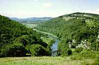
 Black Mountains from Kymin |
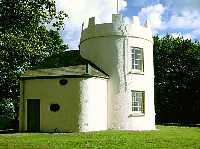 The Round House |
The next section into Monmouth climbs steadily up a track followed by a path to Kymin Tower with widening views opening up as the ascent progressed. Part way up I stopped for a rest and was passed by a lone walker carrying camping gear. He was doing the whole walk but had no definite schedule as he had three weeks holiday. I didn't realise at the time that I would meet up with Alan more than anyone else throughout the rest of the walk. At the summit of Kymin Tower, which is about 700ft above the river, I was treated to a superb view westwards overlooking Monmouth towards Skirrid, Sugar Loaf and the Black Mountains. There are a couple of interesting buildings on top; the Round House built in 1794 and the Naval Temple added in 1800 to commemorate victorious admirals of that era.
After a short while admiring the views, I made my way down the steep path towards Monmouth. I had been advised to take the disused railway bridge across the river to avoid walking through the town centre, but I thought it would be just as well to take a look at the town whilst I was passing. It is a pleasant town dominated by a large private school and it has a castle as well as the well preserved 13th century Monnow Bridge with fortifications in the middle. By the time I reached my B&B for the night at 6.40 p.m., I was quite footsore having walked over 20 miles, which is never a good thing on the first day.
![]()
 Monnow Bridge, Monmouth |
I was given a friendly greeting and a cup of tea, which was very refreshing and then I had a bath, which was even more refreshing, before going into town for a steak pie and chips in the Green Dragon. I had a pint of London Pride, which was quite good but then decided to try the Young's Special but found that it had turned to vinegar and was virtually undrinkable. Experience has told me that it is generally unwise to complain about the beer in a pub as it is usually taken as meaning that you are a trouble maker, so I sat there for a while taking only a few sips from the glass. In the meantime, a jazz group had started playing rather badly at first but improving a little as they warmed up. However, when they took a break I took the opportunity to leave and had another couple of pints in the Gatehouse before retiring for an early night.
[Index of Walks]
[Previous]
[Top]
[Next]